We found 109182 price guide item(s) matching your search
There are 109182 lots that match your search criteria. Subscribe now to get instant access to the full price guide service.
Click here to subscribe- List
- Grid
-
109182 item(s)/page


Lot 86
A second edition of 'A true account and declaration of the horrid conspiracy against the late King His Present Majesty and the government', 'As it was order'd to be published by His late Majesty', printed by Thomas Newcomb 1685, providing an account of the Rye House plot to kill James II, including 'Copies of the Informations' and a fold out map of Rye House by Oliver Sculp, bound in leather with the name to the spine


Lot 830
FOUR FRAMED MAPS, to include 'A Map of the Great Levell, representing it as it lay drowned' possibly by Jonas Moore depicting the Fens during a flood, Robert Mordon map of Northamptonshire, map of Shropshire by J Carey and a map titled 'The Old World Showing British Possessions and Trade Routes' largest size approximately 37cm x 45cm

Lot 132
FIVE VINTAGE COMPACTS, to include three Statton compacts, one with engine turned detail, one with foliate detail to the lid, one with coloured flowers and green background to the lid, together with a rectangular compact with 'Pitt 1941 Military Ball' printed to the lid and a circular compact with California map to the lid


Lot 418
An interesting album of photographs of Australia, 1945, with approx 140 snapshots, postcards and a few whole and half plate photos, some commercially produced and titled, compiled by a nurse, Bessie Beatson, with her studio portrait and Certificate of War Service, a copy of the "Pacific Post", 20th July 1945, with details of current strikes against Japan, the resumption of Test cricket, etc; in a leather album, 11" x 15", the front cover impressed with map of Australia and Aboriginal figures. GC


Lot 431
Irene Sinclair, Landscape Watercolour titled ' From the Red Rocks ', 36cms x 51cms, framed and glazed together with Impressionist Landscape Watercolour indistinctly signed, 17cms x 18cms, framed and glazed and Ordnance Survey Coloured Geological Survey Map of North Wales, reprinted 3rd impression 1968, 52cms x 75cms, framed and glazed

Lot 6101
(Hunting, Shooting, Fishing, collection of 12 titles from the library of Sir John Ruggles Brise (1908-2007), 2nd Baronet, Lord Ltnt. of Essex 1958-78, of Spains Hall, Finchingfield, Essex), including Wheeldon: 'Angling Resorts Near London, the Thames and the Lea', London, 1878, 1st edition, original pictorial brown cloth gilt (worn); Arthur Walker: 'The Rifle; Its Theory and Practice', 1864, 2nd edition, illustrations in text as called for, original pictorial cloth gilt, fontis with small part excised at top corner (removing oval blindstamp), no other markings, pages 195-206 loose; James Wilson: 'The Rod and the Gun Being Two Treatises on Angling and Shooting', Edinburgh, A & C Black, 1841, engraved frontis + 8 plates and ills. in text as called for, contemporary blindstamped cloth gilt, rebacked, original backstrip retained; Frederick Henry Bright: 'Epitome of the Game Laws', Maldon, Gowers Ltd, for Essex Poaching Prevention Society, 8pp + index, contemporary red cloth gilt, armorial bookplate to front paste down; Sydney Buxton: Fishing and Shooting', 1903, 3rd edition, signed and inscribed "with all thanks and good wishes, Buxton, April 1915" to first blank, plus relevant cutting and m/s pen & ink note on Tilbury Hall, Essex headed paper dated Nov 9 1951, original pictorial cloth gilt, top edge gilt; Robin Chute: 'Shooting Flying - A Bibliography of Shooting Books 1598-1950', 2001, ltd edn (238/500), signed and numbered, 16 coloured and black and white plates as called for, folio, original cloth gilt; Charles Alington: 'Partridge Driving', London, 1904, folding map + folding table as called for, ownership signature EA Ruggles Brise, original pictorial cloth gilt, plus 5 others similar (12)

Lot 6026
Revd. A.P. Purey-Cust: 'The Heraldry of York Minster', Leeds, Richard Jackson, 1890-96, limited edition (136/300), numbered, two volumes, 22 coloured plates + coloured map + 6 black and white plates as called for, large 4to, original pictorial cloth gilt, ex library, backstrip reference marks and labels from front pastedowns removed, plus Platt & Morkill: 'Records of the Parish of Whitkirk', Leeds, Richard Jackson, 1892, ltd edn (135/200), numbered, black and white plates and ills. as called for, large 4to, original cloth gilt (3)
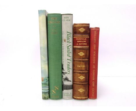
Lot 6081
George Christopher Davies, two titles: 'Norfolk Broads and Rivers or The Water-ways, Lagoons, and Decoys of East Anglia', 1883, first edition, twelve photogravure plates as called for, internally VGC, contemporary half calf, later rebacked leather, spine gilt in compartments, morocco gilt title label to spine, 'The Handbook to the Rivers and Broads of Norfolk & Suffolk', c.1890, 18th edition, lacks folding map in pocket at rear, original pictorial cloth gilt + Ted Ellis: 'The Broads', 1965, first edition, original cloth gilt + Roy Clark: 'Black Sailed Traders', 1972, 2nd impression, original cloth, dust wrapper + one other similar (5)
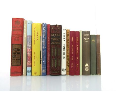
Lot 6037
(Essex Topography & History, collection of 16 titles from the library of Sir John Ruggles Brise (1908-2007), 2nd Baronet, Lord Ltnt. of Essex 1958-78, of Spains Hall, Finchingfield, Essex), including Moncrieff & Burleigh Bruhl: 'Essex', A & C Black, 1909, first edition, grangerized copy, 75 coloured plates, folding map and extra illustrated with additional tipped in black and white prints etc, 16 Essex crests and monograms mounted verso FFEP & half title, original pictorial cloth gilt, top edge gilt, plus 'Kelly's Directory of Essex 1937', folding coloured map. original cloth gilt, plus Neale: 'An Essex Tribute', 1987, first edition, Ruggles Brise armorial bookplate, plus Eliza Vaughan: 'The Essex Village in Days Gone By', Colchester, Benham, 1928, first edition, original cloth gilt, Ruggles Brise armorial bookplate, plus 12 others similar (16)
!['Picture Story of Old Chinese Farming', [Shanghai?], circa 1924, 10 mounted watercolour illustrations on silk depicting tradi](https://cdn.globalauctionplatform.com/dcea242e-23e8-4d91-9ce1-aaa000ae9cfe/bfadaf86-6bb6-45ed-90a3-aab2010daba2/468x382.jpg)
Lot 6004
'Picture Story of Old Chinese Farming', [Shanghai?], circa 1924, 10 mounted watercolour illustrations on silk depicting traditional rice farming, English and Chinese printed text, folding concertina album, original silk covered boards + 'Complete Pictures of the Eight Noble Steeds', circa 1920, 10 mounted watercolour illustrations on silk depicting ancient Chinese Emperors and their horses, English and Chinese printed text, folding concertina album, original wooden boards + Peter FLeming: 'News from Tartary: A Journey from Peking to Kashmir', 1936, first edition, folding map and illustration as called for, original cloth gilt (3)
![[William Smith. 1727-1803]: 'An Historical Account of the Expedition against the Ohio Indians, in the year MDCCLXIV. Under th](https://cdn.globalauctionplatform.com/dcea242e-23e8-4d91-9ce1-aaa000ae9cfe/3da6727e-2e02-43a7-a7d1-aab2010df19a/468x382.jpg)
Lot 6110
[William Smith. 1727-1803]: 'An Historical Account of the Expedition against the Ohio Indians, in the year MDCCLXIV. Under the Command of Henry Bouquet, Esq. Colonel of Foot, and now Brigadier General in America. Including his Transactions with the Indians, Relative to the Delivery of their Prisoners, And the Preliminaries of Peace. With an introductory account of the preceding Campaign, and Battle of Bushy-Run', London, T. Jefferies, 1766, first English edition, (a/f), a defective copy, lacking the folding frontispiece map of the Ohio region, but with the two engraved plans after Thomas Hutchins, and the two engraved plates after Benjamin West by Grignion and Canot. 'Plan of the Battle near Bushy Run' with marginal loss of paper top right corner, small closed tear just within plate impression not affecting engraving, and area of soiling at top margin just affecting inside plate impression, but not effecting engraving, else VGC. The other battle plan with similar marginal loss of paper top right corner, area of soiling at top margin, and general toning/browning of paper. The plate titled 'The Indians giving a Talk to Colonel Bouquet in a Conference at a Council Fire...Octr. 1764' trimmed close to plate impression at tope edge, marginal losses, chipping, toning of paper, closed tear at fore edge affecting approx 4cm of engraving. The plate titled 'The Indians delivering up the English Captives to Colonel Bouquet...Novr. 1764' depicting a white boy recoiling from a British soldier, seeking refuge in the arms of his adopted Indian mother and father, in a pitiful scene, with marginal creases and losses of paper and loss of small part of top left corner of engraving. The body of text complete, [2],xiii,[1 blank],71 pp., but with losses of paper at top edge and spine edge of leaves towards top corner throughout, title page only loss of text the initial 'An', some losses affecting printed text throughout, mainly the last twenty pages, but vast majority of text unaffected, soiling/staining at top edge of leaves throughout, and generally toning, marginal chipping and creasing, marginal closed tears and some marginal losses throughout. Quarto, disbound, a serious conservation/restoration project, but a scarce and important work
![[John Chambers]: 'A General History of the County of Norfolk, intended to convey all the information of a Norfolk tour, with](https://cdn.globalauctionplatform.com/dcea242e-23e8-4d91-9ce1-aaa000ae9cfe/66f0508a-a63b-49b7-ab2f-aab2010dcc49/468x382.jpg)
Lot 6054
[John Chambers]: 'A General History of the County of Norfolk, intended to convey all the information of a Norfolk tour, with the more extended details of antiquarian, statistical, pictorial, architectural, and miscellaneous information; including biographical notices, original and selected', Norwich, John Stacy, 1829, first edition, two volumes, vol 1 engraved hand coloured folding county map frontis, vol 2 engraved frontis depicting Norwich Cathedral, as called for, rebound uniform quarter calf gilt, leather gilt title labels to spines, new EP's

Lot 6039
(Essex Topography & History, collection of 16 titles from the library of Sir John Ruggles Brise (1908-2007), 2nd Baronet, Lord Ltnt. of Essex 1958-78, of Spains Hall, Finchingfield, Essex), including Eliza Vaughan: 'Stephen Marshall, A Forgotten Essex Puritan', 1907, 1st edition, 6 plates as called for, original cloth gilt; Bruhl & Moncrieff: 'Essex', A & C Black, 1909, 1st edition, 75 coloured plates + folding map as called for, original pictorial cloth gilt, top edge gilt; plus 3 titles Braintree & Bocking; others Essex Parish Records; Cavendish; Audley End etc etc (12)


Lot 6015
G.F. Cruchley (published): 'Cruchley's New Map of The World on Mercator's Projection Showing the Discoveries at the North Pole and the New Settlements in Australia, New Zealand &c', London, G.F. Cruchley, circa 1853, engraved hand coloured map, two separate folding sheets backed onto linen, the entire printed area of map across the two sheets approx size 95 x 168cm, worn, generally toned, some grubby areas, one or two stains and very small puncture holes, contemporary half morocco gilt, morocco gilt label to upper cover
Lot 6098
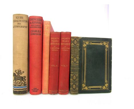
(Hunting and Sporting interest, collection of 7 volumes from the library of Sir John Ruggles Brise (1908-2007), 2nd Baronet, Lord Ltnt. of Essex 1958-78, of Spains Hall, Finchingfield, Essex), including Colonel Anstruther Thomson: 'Eighty Years' Reminiscences', London, 1904, 1st edition, 2 volumes, plates and plans as called for, original cloth gilt; Nimrod [i.e. CJ Apperley]: 'The Chace, the Turf, and the Road', illustrated Henry Alken, London, 1837, 1st edition, engraved portrait frontis + 13 engraved plates as called for, contemporary green morocco (worn), gilt tooled decoration to boards, spine gilt in compartments, all edges gilt; Lionel Edwards (illustrated): 'Hunting By Scent', 1933, reprint, 12 plates as called for, 4to, original cloth gilt; Charles Simpson: 'Trencher & Kennel', 1927, 1st edition, 24 coloured + 68 black and white plates as called for, large 4to, original cloth (VGC), leaves uncut; E.D. Cuming: 'Squire Osbaldeston: His Autobiography', 1926, 1st edition, 16 coloured + 75 black and white plates + folding map as called for, large 4to, original buckram (6)

Lot 6075
Peter Henry Emerson: 'Birds Beasts and Fishes of the Norfolk Broads', London, 1895, first edition, first issue, 68 illustrations from black and white photographs as called for (of which 18 full page plates), original pictorial cloth gilt (a VGC copy) + Arthur Henry Patterson: 'A Norfolk Naturalist: Observations on Birds, Mammals and Fishes', 1930, first edition, frontis + 35 illustration in text as called for, rebound quarter green morocco gilt, marbled paper covered boards + Suffling: 'The Land of the Broads', c.1895, new and revised edition, lacks map, original pictorial cloth gilt + Annie Berlyn: 'Sunrise-Land. Rambles in Eastern England', illustrated Arthur Rackham, 1894, first edition, original pictorial cloth (slightly soiled) (4)
Lot 6053
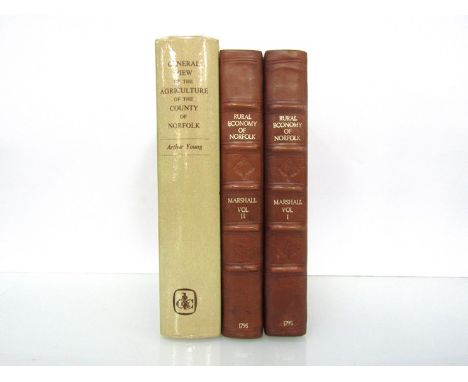
William Marshall: 'The Rural Economy of Norfolk: Comprising the Management of Landed Estates, and the Present Practice of Husbandry in that County', 1795, second edition, two volumes, engraved folding map as called for ("East Norfolk" & "Sketch of the County" on one single folding sheet), two neat repairs verso, contemporary tree calf, later rebacked calf, gilt titling to spines, new EP's + Arthur Young: 'General View of the Agriculture of the County of Norfolk', 1969 facsimile reprint of the 1804 first edition, folding map and folding table as called for, original cloth, dust wrapper (laminated) (3)

Lot 6062
'Norfolk Record Society', thirteen assorted volumes 1947-1998, each original cloth gilt, including 'Faden's Map of Norfolk', 1975, vol XLII, text booklet + 6 folding maps as called for, original slipcase, plus 'Norfolk Genealogy', 1969-1993, 26 volumes (25 volume consecutive run plus duplicate of vol 5), each original cloth gilt, plus 'Norfolk Domesday Book', Phillimore, 1984, two volumes, original cloth, dust wrappers & 'The Place Names of Norfolk', 1989-1996, parts one and two, two volumes, original cloth, dust wrappers (43)

Lot 6220
An 18th Century engraved, hand coloured road strip map, 'King's Lynn to Norwich and Yarmouth in Norfolk', circa 1759, based on the John Senex strip map from 'An Actual Joining of all the Principal Roads of England and Wales', 1719, from St George's French edition 1759, approx. 16.5 x 21cm, framed and glazed, the whole approx. 29 x 34cm

Lot 6058
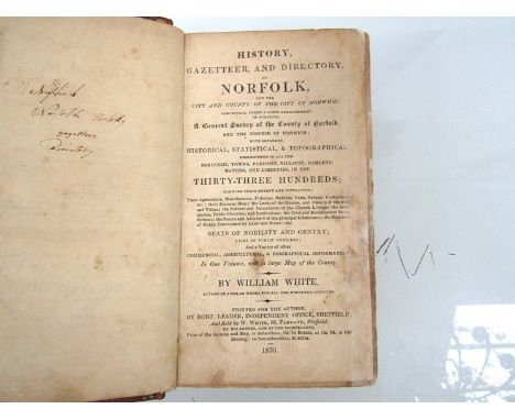
Francis Blomefield and Charles Parkin: 'An Essay Towards a Topographical History of the County of Norfolk...', Fersfield and Lynn, 1739-1775, first edition, five volumes, 42 engraved plates/plans/folding genealogical tables + numerous engravings in the text, a handsomely bound excellent set from the library of Rev. John Hare Beevor (1861-1914), son of Sir Thomas Beevor 4th bt. and Sophia Chevallier, widow of Isaac Jermy of Stanfield Hall, Thomas Beevor of Hethel is listed in the subscribers. Volume 1. Without the list of subscribers (stated as "scarce" by Lowndes and rare according to Ron Fiske, late of Morningthorpe Hall, authority on Norfolk History and Heraldry) otherwise as Upcott including the "scarce" Blomefield pedigree.Volume 2. Without the dedication to John Nuthall ("scarce" Lowndes) and without the separate sheet of map references ("scarce" Lowndes). Otherwise as Upcott including the "scarce" two sheet plan of Norwich.Volumes 3, 4 and 5. as Upcott. Finely bound in contemporary speckled calf, sympathetically later rebacked retaining contemporary spines gilt in compartments, morocco gilt title labels, armorial bookplates of Rev. John Hare Beevor to front pastedowns, together with the very scarce specimen pamphlet 'Specimen of the Edition of Blomefield's History of Norfolk, In Ten Volumes Royal Octavo, now in the press.', [nd], circa 1805, 16pp pamphlet, engraved vignette of Diss church, and a wood engraving, original brown wrappers with original printed label to top wrap, housed in custom made green cloth protective folder with green leather gilt title label to spine (6)

Lot 6014
Ten titles on Victorian continental spa and health resorts including A.B. Granville: 'The Spas of Germany', London, Henry Colburn, 1843, second edition, 5 maps + 13 plates as called for, rebound half blue morocco gilt, new EP's/pastedowns, plus Edwin Lee: 'The Principal Baths of Germany, France and Switzerland...First Volume. Baths of Germany.', London, Churchill, 1863, 4th edition revised, viii,308pp, rebound papered boards, printed label to spine, plus Derwent Conway [i.e. David Henry Inglis]: 'Switzerland, the South of France, and the Pyrenees, in M.DCCC.XXX', Edinburgh, Constable, 1831, 1st edition, 2 volumes, 2 added engraved vignette title pages + engraved folding map as called for, contemporary blindstamped cloth gilt, plus Hermann Weber: 'The Mineral Waters and Health Resorts of Europe;, London, Smith Elder, 1898, large folding map in rear pocket as called for, original cloth gilt, plus Sidney Light: Medical Climatology', New Haven, CT., 1964, signed and inscribed, rebound black and navy morocco gilt, plus 4 others similar (10)
Lot 6007
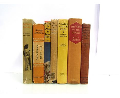
Collection of 7 titles Middle East interest, including G. Wyman Bury: 'Arabia Infelix, or The Turks in Yamen', London, Macmillan, 1915, 1st edition, black and white frontis + 17 full page black and white plates + 3 coloured maps as called for, original cloth; H.R.P. Dickson: 'The Arab of The Desert - A Glimpse into Badawin Life in Kuwait and Sau'di Arabia', London, George Allen, 1951, 2nd edition, black and white frontis + 48 full page black and white illustrations on 28 full page plates, + 4 leaves with coloured plates on each side + 6 folding pedigree charts + 5 folding maps in sleeve at rear (as issued? some bibliographies call for 5 folding maps, others 8, 'Sketch Map Showing Motor Road from Riyadh to Kuwait No.1 - 2 - 3' not present as often the case), original cloth gilt; Harold Ingrams: 'Arabia and the Isles', London, 1966, 3rd edition enlarged, folding map + illustrations as called for, original cloth gilt, dust wrapper; Alfred Guillaume: 'The Traditions of Islam', Oxford, 1924, 1st edition, armorial bookplate of John Ernest Buttery Hotson (1877-1944), administrator in India during the British Raj, original cloth gilt, dust wrapper, plus 3 others similar (7)

Lot 6063
Rev. William Hudson and John Cottingham Tingey: 'The Records of the City of Norwich', Norwich and London, 1906, first edition, two volumes, folding frontis map as called for, original cloth gilt, plus A.D. Bayne: 'A Comprehensive History of Norwich', 1869, original blindstamped cloth gilt (spine edges worn and rubbed), book plate of James Reeve (1833-1920) curator Norwich Castle Museum, plus Peter Eade: 'The Norfolk and Norwich Hospital 1770-1900', 1900, first edition, inscribed by the author, original cloth gilt, plus Basil Cozens-Hardy and Ernest A. Kent: 'The Mayors of Norwich 1403 to 1835', 1938, first edition, signed and inscribed by Cozens-Hardy and signed by Kent, original cloth gilt, plus J. Evans & J. Britton: 'The Beauties of England and Wales', 1810, volume XI (Norfolk), two engraved plates (Norwich Market and Castle Acre Priory) only, rebound cloth gilt, plus Walter Rye: 'Monographs of Norwich Hamlets. History of the Parish of Eaton... - Earlham... - Hellesdon... - Heigham... - Catton...', Norwich, Roberts & Co, [1917]-1919, first edition, five parts in one, numerous folding maps, 286pp, contemporary cloth gilt, plus G.B. Jay: 'The First Parish Register of St. George of Tombland...', 1891, limited edition (98), out of series, quarto, original cloth gilt, plus three others Norwich interest (11)
Lot 6008
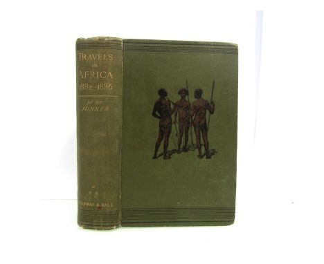
Wilhelm Junker: 'Travels in Africa during the years 1882-1886', London, Chapman & Hall, 1892, first English edition, portrait frontispiece, large folding map, plus numerous black and white plates and illustrations in text as called for, original pictorial cloth gilt. The third of three works describing the author's travels in Africa, for which Junker was awarded a gold medal from the British Royal Geographical Society


Lot 6060
Six Norfolk and Suffolk directories, including 'White's Directory of Norfolk', 1864, third edition, rebound two tone cloth gilt + 'Kelly's Directory of Norfolk 1896', folding map as called for, original cloth gilt (VGC) + 'Kelly's Directory of Norfolk 1933', folding map as called for, recased retaining original cloth (worn) + 'Kelly's Directory of Suffolk 1937', lacks map, rebound cloth gilt + two others (6)

Lot 6069
Louis H. Dahl: 'The Roman Camp and the Irish Saint at Burgh Castle..with Local History', 1913, first edition, folding map frontispiece + 49 illustrations and plans as called for, original cloth gilt, plus F.J. Gardiner: 'History of Wisbech and neighbourhood during the last fifty years 1848-1898, Wisbech & London, 1898, first edition, ex library, original cloth gilt (worn), top edge gilt, plus A.C. Savin: 'Cromer...A Modern History', Holt, 1937, first edition, signed, original cloth gilt, plus Millican: 'A History of Horstead and Stanninghall', 1937, first edition, original cloth gilt + 8 others similar, all first editions in dust wrappers including Sapwell: 'Aylsham..'; Boston and Puddy: 'Dereham...'; Parsons: 'Salle...'; Erroll: 'Sheringham and Beeston Regis...' etc etc (12)
![Owen & Bowen: ''The Road from Ipswich to Norwich [Ipswich-Claydon-Barham-Stonham Aspal-Scole]', engraved hand coloured ro](https://cdn.globalauctionplatform.com/dcea242e-23e8-4d91-9ce1-aaa000ae9cfe/0c24e6e1-3044-4777-a209-aab2010f5a59/468x382.jpg)

Lot 6013
'Picturesque Europe. The British Isles', 1880, 2 volumes, plates complete, plus W.H. Bartlett & J.S. Coyne: 'The Scenery and Antiquities of Ireland', volume 1 only, engraved vignette title page, engraved map and 60 engraved plates as called for, original cloth (very worn), lacks backstrip, boards detached, lacks rear end paper (3)


Lot 335
LATE VICTORIAN FRAMED EDUCATIONAL POSTER 'BACON'S CHART OF USEFUL KNOWLEDGE' produced by George Washington Bacon of London and with a world map to the centre surrounded in detail by pictorial and textual information relating to the solar system, transport, famous battles, 'The World's Loftiest ... Buildings' and with time chart ETC, 121 x 95cms (including frame) and two framed portraits

Lot 222
London.- Mylne (R.W.) Geological Map of London and its Environs, identifying the varying surface soils of London and its environs, with a geological cross section from Hendon to East Wickham, with title and reference key in the upper right quadrant, engraving with extensive hand-colouring, 415 x 670 mm. (16 1/4 x 26 1/2 in), dissected and mounted on linen, folding with marbled ends into publishers gilt cloth boards, secondary key pasted onto inside upper cover, 8vo, Edward Stanford, 1858.⁂ Scarce, early edition of this fine geological map.

Lot 96
Middle East and Eastern Mediterranean.- De L'Isle (Guillaume) Carte de la Turquie de L'Arabie et de la Perse, map of the Ottoman Empire stretching from the Balkans through present-day Turkmenistan in the north and including Northeastern Africa and the Arabian Peninsula, engraved map with some hand-colouring on laid paper with large armorial watermark containing a Maltese cross, platemark 470 x 625 mm. (18 1/2 x 24 1/2 in), sheet 505 x 680 mm. (19 7/8 x 26 3/4 in), minor surface dirt, small careful repairs to central vertical fold, unframed, [c. 1720 and later].
-
109182 item(s)/page