We found 109182 price guide item(s) matching your search
There are 109182 lots that match your search criteria. Subscribe now to get instant access to the full price guide service.
Click here to subscribe- List
- Grid
-
109182 item(s)/page


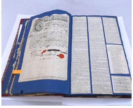
Lot 1317
An album of 18th and 19th Century engravings, prints, cuttings, MS letters, pen, ink and watercolour sketches etc on 55+ pages, much content relating to Wells and Cooke - Yarborough families, Wells family of Devon and later Norfolk including indenture dated 1743 relating to Nathaniel Wells of Malborough, Devon and the appointing of a Nicholas Prettyjohn as his apprentice + quantity assorted cuttings relating to Lieutenant Colonel Henry Lake Wells (1850-1898), Lieutenant Colonel of Royal Engineers, he served in the Afghan campaign of 1878-79, in sole charge of the Public Works Department at Quetta where he built the native cantonments and was later present at the action of Majina and had charge of the positions at the crossing of the Kabul River and was mentioned five times in despatches, being recommended for conspicuous gallantry and bravery displayed on the occasion of the attack on a robber encampment under Lascar Khan by a party from the Chamun Post, he spent many years in Persia surveying and rendered services in the de-limitation of the Afghan Frontier in 1886, Army remount operations for India 1887 in the cholera epidemic and during Shiraz revolution 1893, items including printed obituary from The Royal Engineers' Journal December 1st 1898 etc + several cuttings relating to Zulu and Ashanti Wars circa 1870s + engraving of "The Dutton Sluices; River Weaver navigation Mr Lionel B W Wells, Engineer" dated 1884 + MS pen, ink and wash map of Australia circa 19th Century +etching of Ashby-de-la-Zouch etc, modern album hf cf marb bds
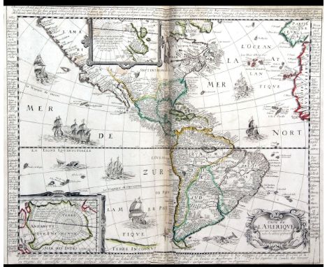
Lot 1427
COMPOSITE ATLAS, circa 1620-1735, containing 53 engrd dbl pge mainly outline col'd/part col'd maps, together with 2 plans and 1 prospect, a qty from Jean Le Clerc's "Theatre Geographique du Royaume France", including A H JAILLOT: L'EUROPE, 1658, J BOISSEAU: NOUVELLE DESCRIPTION DE LA FOREST ROYALLE DE FONTAINEBELLEAU, circa 1650 and DANIA NOVA DESCRIPTO, 1654, P BERTIUS AFTER HONDIUS: CARTE DE L'AMERIQUE, circa 1671, ORTELIUS/JOLLAIN: GRAECIA, 1668 etc, fo, old hf cf worn, Norwich Public Library label on front pastedown, lib reference number verso of 2nd blank, lib stamp verso of 1 map, shelf mark at foot of spine, no other lib markings

![J SPEED: THE COUNTIE OF NOTTINGHAM..., engrd hand col'd map [1676], approx 15" x 20", f/g](https://cdn.globalauctionplatform.com/057972b4-06af-4b2a-b6f8-a4c8009ddd39/8ac96bd6-0328-4b56-ee01-7accd72e2358/468x382.jpg)
![J SPEED: RUTLANDSHIRE, engrvd map [1611], approx 14 3/4" x 19 1/2", f/g](https://cdn.globalauctionplatform.com/057972b4-06af-4b2a-b6f8-a4c8009ddd39/59c1fba6-f204-4e3d-b79d-6316018e1d9c/468x382.jpg)


![J SPEED: THE COUNTIE AND CITIE OF LYNCOLNE DESCRIBED ..., engrd hand col'd map [1611]](https://cdn.globalauctionplatform.com/057972b4-06af-4b2a-b6f8-a4c8009ddd39/27c04bce-8f4d-4c78-b93e-288bf949220b/468x382.jpg)


Lot 397
J M W TURNER: NOTES BY MR RUSKIN ON HIS COLLECTION OF DRAWINGS, L, 1878, 1st edn, engrd frontis + 34 engrd plts + double pge map complete as list, old qtr cf ex-lib + JOHN RUSKIN: MODERN PAINTERS, 1888 1st edn, vol 4, large paper, frontis + 34 plts complete as list, old cl gt + JOHN RUSKIN: LECTURES ON LANDSCAPE DELIVERED AT OXFORD IN LENT TERM 1871, 1897 1st edn, 22 plts complete as list, orig cl gt (3)

Lot 483
HENRY DIRCKS: THE LIFE, TIMES, AND SCIENTIFIC LABOURS OR THE SECOND MARQUIS OF WORCESTER TO WHICH IS ADDED A REPRINT OF HIS CENTURY OF INVENTIONS, 1663, WITH A COMMENTARY THEREON, L, Bernard Quaritch 1865, orig cl gt, rebkd, orig bkstrip retained, new EPs + SAMUEL SMILES: INDUSTRIAL BIOGRAPHY IRONWORKERS AND TOOLMAKERS, Newton Abbot, David & Charles 1967 reprint, orig cl gt, d/w + CHARLES BABBAGE: THE EXPOSITION OF 1851, Farnborough, Gregg International Publishers Limited, 1969 reprint, orig cl gt + G L KERR: ELEMENTARY COAL-MINING ..., L, 1912, 3rd edn rev, orig cl gt worn + ANDREW JAMIESON: ELEMENTARY MANUAL ON STEAM AND THE STEAM ENGINE..., L, 1894, 4th edn, orig cl gt + W P BUCHAN: PLUMBING A TEXTBOOK TO THE PRACTICE OF THE ART OR CRAFT OF THE PLUMBER ..., L, 1900, 8th edn re-written and greatly enlarged, orig cl + WILLIAM TEMPLETON: THE PRACTICAL EXAMINATOR ON STEAM AND THE STEAM ENGINE ..., L, Atchley & Co 1852, orig blind stpd cl gt + J H COLLINS: PRINCIPLES OF COALMINING, [1876], fdg map, orig cl (8)


Lot 606
L S MARSH (ED): ANGLING IN OUSE AND CAM WATERS, circa 1935, orig ptd card wraps, inner jnts split + OGDEN SMITHS LIMITED: "MERMAID" FISHING FLIES, circa 1940, 16 col'd plts, orig card wraps + FRANK HOUSE: HANDBOOK OF COARSE FISHING, 1944, 1st edn, orig pict wraps + [EDWARD ENSOM] "FADDIST": DRY-FLY FISHING FOR CHUB DACE ROACH AND RUDD, 1946, orig wraps + LIEUTENANT COLONEL W KEITH ROLLO: FLY FISHING..., 1947 reprint, orig cl gt + BICKERDYKE: ANGLING FOR COARSE FISH ..., circa 1947, 25th impress, orig wraps + [EDWARD ENSOM] "FADDIST": ROACH FISHING, 1949, 3rd edn, orig cl, d/w + HAMILTON'S ANGLERS GUIDE - THE NORFOLK AND SUFFOLK BROADS, circa 1951, 3 fdg maps in rear pocket + HAMILTON'S TIDE COMPUTER, revolving tide chart disc on cd + 1 other fdg map, orig wraps + THE HOUSE OF HARDY - SUPER BOTTOM FISHING TACKLE CATALOGUE, 1955, 10th edn, orig ptd paper wraps + 13 other asstd angling ttls (22)

![HUDSON STUCK: VOYAGES ON THE YUKON AND ITS TRIBUTARIES, [1917], 1st edn, frontis, 48 plts, 2 maps (both with some damage), or](https://cdn.globalauctionplatform.com/057972b4-06af-4b2a-b6f8-a4c8009ddd39/559ca0e4-d4fa-4afe-cf0d-b4a9210298d6/468x382.jpg)
Lot 666
HUDSON STUCK: VOYAGES ON THE YUKON AND ITS TRIBUTARIES, [1917], 1st edn, frontis, 48 plts, 2 maps (both with some damage), orig cl, gt, ex lib + MAJOR W T BLAKE: FLYING ROUND THE WORLD, 1923, 1st edn, frontis, 11 plts, 1 map compl, orig cl gt, ex lib + MICHAEL TERRY: ACROSS UNKNOWN AUSTRALIA, 1925, 1st edn, frontis, 23 plts, 1 map compl, orig cl, ex lib + LIONEL A D LESLIE: WILDERNESS TRAILS IN THREE CONTINENTS..., foreword for Winston S Churchill, 1931 1st edn, frontis, 23 plts compl, orig cl, ex lib (4)


Lot 690
JOHN RUTTER: DELINEATIONS OF FONTHILL AND ITS ABBEY, L, 1823, 1st edn, engrd hand col'd frontis, added engrd hand col'd ttl pge, engrd vig ttl pge + 1 engrd hand col'd plt, 10 engrd monochrome plts, 15 engrd vigs + lge fdg map and 3 genealogical tables, orig ptd bds, rebkd qtr cf gt, lge 4to

![ALAN PARSONS: A WINTER IN PARADISE, L, A M Philpot [1926], 1st edn, frontis, 13 plts, 1 map compl, orig cl bkd bds gt](https://cdn.globalauctionplatform.com/057972b4-06af-4b2a-b6f8-a4c8009ddd39/0cf592d3-bbda-44e9-b4b4-577cb14d0861/468x382.jpg)


![H T SORTWELL: GEOGRAPHY OF THE COUNTRY OF SUFFOLK ADAPTED TO THE NEW CODE, L, Collins [1872], dbl pge col'd map, mod rebnd qt](https://cdn.globalauctionplatform.com/057972b4-06af-4b2a-b6f8-a4c8009ddd39/25bb3f8d-4ad2-45c2-b8e2-1052335a1361/468x382.jpg)
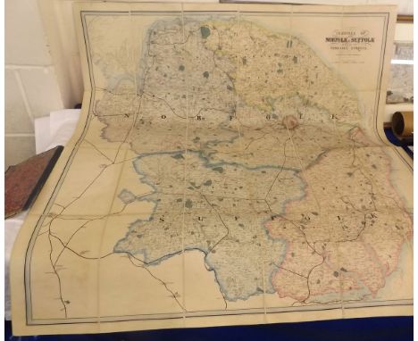
Lot 737
H T SORTWELL: GEOGRAPHY OF THE COUNTRY OF SUFFOLK ADAPTED TO THE NEW CODE, L, Collins [1872], dbl pge col'd map, mod rebnd qtr cf, orig card wraps bnd in + DANIEL DEFOE: TOUR THROUGH THE EASTERN COUNTIES, Ipswich, East Anglian Magazine 1949 reprint, orig cl, d/w + SUFFOLK OLD AND NEW - EAST AND WEST, Printed at The Ancient House Press Ipswich, nd, circa 1910, mod rebnd qtr cf, orig ptd wraps bnd in + CUMING WALTERS (ED): BYGONE SUFFOLK ITS HISTORY, ROMANCE, LEGEND, FOLKLORE ETC, L, A Brown & Sons Ltd, [1900], orig cl gt + A JOBSON: SUFFOLK VILLAGES, 1971 1st edn, orig cl gt, d/w + A O D CLAXTON: THE SUFFOLK DIALECT OF THE TWENTIETH CENTURY, 1960 2nd edn, orig cl gt (6)


Lot 778
P H EMERSON: BIRDS BEASTS AND FISHES OF THE NORFOLK BROADLAND, L, David Nutt 1895, 1st edn, 1st iss, 68 ills compl, orig pict cl + ARTHUR HENRY PATTERSON: ROUGH SKETCHES OF BIRD-LIFE 1910, circa 1986, limited edn (250) numbered, obl, orig hf cf gt + W A DUTT: THE NORFOLK AND SUFFOLK COAST, L, 1909, col'd frontis + 40 black and white plts compl, orig cl gt + JARROLDS' MAP OF THE RIVERS AND BROADS OF NORFOLK AND SUFFOLK, L, 1887, fdg map in linen, scale 1" to a mile, approx 26" x 26", orig bds gt, cover ttl "Rivers and Broads of Norfolk and Suffolk G C Davies" + one other Jarrold map of Rivers and Broads, fdg paper map circa 1930s (A/F) loosely inserted (4)

Lot 780
T HUGH BRYANT: THE CHURCHES OF NORFOLK - HUNDRED OF SHROPHAM - HUNDRED OF BROTHERCROSS, Norwich 1913, 1914, 2 vols, each unif cl gt + PAUL CATERMOLE: THE CHURCH BELLS OF NORFOLK - THE HUNDRED OF DISS, Aylsham 1996, orig ptd wraps + L STILGOE: THE ROUND TOWER CHURCHES OF NORFOLK, Norwich, Canterbury Press 2001, 1st edn, obl, orig pict laminated wraps + H MUNRO COURTLEY: SUFFOLK CHURCHES AND THEIR TREASURES, 1937 1st edn, 3 col'd plts + fdg map compl, orig cl + W J GOODE: ROUND TOWER CHURCHES OF SOUTH EAST ENGLAND, [1994], 1st edn, orig pict laminated wraps + NEIL BATCOCK: THE RUINED AND DISUSED CHURCHES OF NORFOLK, East Anglian Archaeology Report No 51 1991, orig pict laminated wraps (7)

Lot 783
G CHRISTOPHER DAVIES: NORFOLK BROADS AND RIVERS OR THE WATER-WAYS, LAGOONS AND DECOYS OF EAST ANGLIA, 1884 new edn, black and white frontis + six black and white plts compl, old full cf gt + ERNEST R SUFFLING: THE LAND OF THE BROADS..., [1895], 20th thousand, fdg col'd map split at folds, orig pict cl gt + AUGUSTUS J C HARE: THE GURNEYS OF EARLHAM, L, 1895, 2 vols, orig unif cl gt + R W KETTON-CREMER: SIR WILLIAM PASTON, priv ptd 1951, sigd and inscr, orig ptd wraps + HELEN CAROLINE COLMAN: JEREMIAH JAMES COLMAN A MEMOIR, L, priv ptd at The Chiswick Press 1905, orig cl gt, teg + IAN ATHERTON AND OTHERS (EDs): NORWICH CATHEDRAL, CHURCH, CITY AND DIOCESE, 1096-1996, 1996 1st edn, orig cl gt, d/w (7)

Lot 784
P H EMERSON, 3 ttls: MARSH LEAVES FROM THE NORFOLK BROAD-LAND, 1898 trade edn, fdg frontis map, orig pict cl; ON ENGLISH LAGOONS BEING AN ACCOUNT OF THE VOYAGE OF TWO AMATEUR WHERRYMEN ON THE NORFOLK AND SUFFOLK RIVERS AND BROADS, 1893, 1st edn, 2pp advts at end, orig pict cl; BIRDS BEASTS AND FISHES OF THE NORFOLK BROADLAND, L, David Nutt 1895, 1st edn 1st iss, orig pict cl worn + NANCY NEWHALL: P H EMERSON THE FIGHT FOR PHOTOGRAPHY AS A FINE ART, NY, Aperture, circa 1975, orig pict laminated wraps (4)
![[R BEATNIFFE]: THE NORFOLK TOUR OR TRAVELLERS POCKET COMPANION..., 1808 6th edn, engrd fdg frontis map, 12 mo, rebnd (not rec](https://cdn.globalauctionplatform.com/057972b4-06af-4b2a-b6f8-a4c8009ddd39/d864a4c9-1988-4a7d-c9ed-35390bb5af10/468x382.jpg)

![[THOMAS KITSON CROMWELL]: EXCURSIONS IN THE COUNTY OF NORFOLK COMPRISING A BRIEF HISTORICAL AND TOPOGRAPHICAL DELINEATION OF](https://cdn.globalauctionplatform.com/057972b4-06af-4b2a-b6f8-a4c8009ddd39/55dc6381-5a6f-4cb8-d7f1-9817222d8631/468x382.jpg)

Lot 791
ARTHUR HENRY PATTERSON, 3 ttls: NOTES OF AN EAST COAST NATURALIST, 1905 2nd edn, 12 col'd plts compl; NATURE IN EASTERN NORFOLK, 1906 2nd edn, 12 col'd plts + black and white map, inner jnt weak reinforced with tape, orig cl gt; WILD-FOWLERS AND POACHERS FIFTY YEARS ON THE EAST COAST, 1929, 1st edn, 12 black and white ills on 8 full pge plts compl, orig cl gt (3)
Lot 799
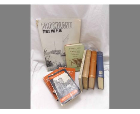
ROBERT FORBY: THE VOCABULARY OF EAST ANGLIA, the 1970 facs reprint edn, 2 vols each orig cl gt, d/ws + E FELCE AND T H BARRY: PICTURESQUE NORFOLK A GUIDE TO THE SOME OF THE CHARACTERISTIC BEAUTY SPOTS OF THE COUNTY 1939 AND 1940, Norwich, A E Soman & Co Ltd [1940], 4 maps of 3 fdg, orig pict ptd wraps + ARTHUR YOUNG: GENERAL VIEW OF THE AGRICULTURE OF THE COUNTY OF NORFOLK, 1969 facs reprint, fdg map, fdg table, orig cl, d/w + H C DARBY: THE DOMESDAY GEOGRAPHY OF EASTERN ENGLAND, 1952, 1st edn, orig cl gt + HISTORICAL MANUSCRIPTS COMMISSION - REPORT ON THE MANUSCRIPTS OF THE MARQUESS OF LOTHIAN PRESERVED AT BLICKLING HALL NORFOLK, L, HMSO 1950, rebnd cl gt, new EPs, orig wraps bnd in + PERCY MILLICAN: A HISTORY OF HORSTEAD AND STANNINGHALL NORFOLK, 1937 1st edn, orig cl gt + J M LAMBERT AND OTHERS: THE MAKING OF THE BROADS A RECONSIDERATION OF THEIR ORIGIN IN THE LIGHT OF NEW EVIDENCE, L, John Murray, 1960, Royal Geographical Society Research Series No 3, orig cl + BROADLAND STUDY AND PLAN - REPORT OF THE BROADS CONSORTIUM COMMITTEE TO THE BROAD CONSORTIUM OCTOBER 1971, 1971, orig pict laminated wraps worn

Lot 803
A PICTORIAL AND DESCRIPTIVE GUIDE TO GREAT YARMOUTH, THE BROADS OF NORFOLK AND SUFFOLK NORWICH LOWESTOFT ETC, L, Ward Lock & Co Ltd, circa 1938, 10th edn rev, fdg col'd map, orig limp cl + F J MEYRICK: ROUND ABOUT NORFOLK AND SUFFOLK, [1926], 1st edn, orig cl + [E J LUPSON]: ST NICHOLAS' CHURCH GREAT YARMOUTH ITS HISTORY, ORGAN, PULPIT, LIBRARY ETC, [1881], 1st edn, orig blind stpd cl rebkd + W R RICHMOND: THE STORY OF GREAT YARMOUTH, L, Jarrold & Sons circa 1910, orig cl + JONATHAN MARDLE: AS I WAS A-SAYIN', 1950 1st edn, orig cl + LOIS A FISON: SPINNING DAYS AND OLDEN WAYS A SUFFOLK STORY, Ipswich 1904 1st edn, orig silk-covered bds gt + YARMOUTH HAVEN, 1981 1st edn, subscribers copy numbered, orig cl gt + A W ECCLESTONE: A YARMOUTH MISCELLANY, 1974 1st edn, 2 fdg maps compl, orig cl gt (8)

Lot 807
A PICTORIAL AND DESCRIPTIVE GUIDE TO THE BROADS AND RIVERS OF NORFOLK AND SUFFOLK INCLUDING A SECTION ON GREAT YARMOUTH ..., L, Ward Lock & Co Ltd, circa 1919, 2nd edn rev, 3 fdg maps, orig limp cl + G CHRISTOPHER DAVIES: THE HANDBOOK TO THE RIVERS AND BROADS OF NORFOLK AND SUFFOLK, [1891], 18th edn, fdg map in pocket at end, orig pict cl + ANNA BOWMAN DODD: ON THE BROADS, ill Joseph Pennell, 1896 1st edn, lacks ffep, orig decor cl gt + PICTURES IN COLOUR OF THE NORFOLK BROADS, Norwich and L, [1905] 1st edn, orig two-tone cl (4)
![G CHRISTOPHER DAVIES, 2ttls: THE HANDBOOK TO THE RIVERS AND BROADS AND NORFOLK AND SUFFOLK, [1883], 3rd edn, 2 leaves loose,](https://cdn.globalauctionplatform.com/057972b4-06af-4b2a-b6f8-a4c8009ddd39/3d2006a0-797a-444d-8d3b-74282dcc01e7/468x382.jpg)
Lot 808
G CHRISTOPHER DAVIES, 2ttls: THE HANDBOOK TO THE RIVERS AND BROADS AND NORFOLK AND SUFFOLK, [1883], 3rd edn, 2 leaves loose, lacks map in pocket at end, orig cl gt worn; NORFOLK BROADS AND RIVERS OR THE WATERWAYS, LAGOONS AND DECOYS OF EAST ANGLIA, 1883, 1st edn, 12 photogravure plts by T & R Annan as list, orig cl gt (2)
![G CHRISTOPHER DAVIES: THE HANDBOOK TO THE RIVERS AND BROADS OF NORFOLK AND SUFFOLK, [1891], 18th edn, rev and enlarge with ma](https://cdn.globalauctionplatform.com/057972b4-06af-4b2a-b6f8-a4c8009ddd39/38b0768f-6409-46a5-d3d0-7bfd279c3a7d/468x382.jpg)
Lot 810
G CHRISTOPHER DAVIES: THE HANDBOOK TO THE RIVERS AND BROADS OF NORFOLK AND SUFFOLK, [1891], 18th edn, rev and enlarge with map in pocket at end, orig pict cl gt + ERNEST R SUFFLING, 2 ttls: HISTORY AND LEGENDS OF THE BROADS DISTRICT ..., [1891] orig pict cl gt; THE LAND OF THE BROADS..., [1892], [2nd edn], fdg frontis map, orig pict cl gt (3)
Lot 15
BILLINGSLEY (John): 'General View of the Agriculture of the County of Somerset with Observations on the Means of its Improvements..'; Bath, R. Cruttwell, 1798; 8vo, period quarter calf, rubbed and scuffed; with folding map; together with a quantity of miscellaneous antiquarian, largely 18th-19th century, to include: a first edition of Carsten Borchgrevink's 'First on the Antarctic Continent', 1901, lacking maps but inscribed from the author to the half title. (Three shelves)

Lot 196
WADSWORTH (Edward) & WINDELER (Bernard): 'Sailing Ships and Barges of the Western Mediteranean and Adriatic Seas..'; London, Etchells & MacDonald, 1926. One of 450 copies, out of series; with map and seventeen plates, some hand-coloured. Small folio, orig. cloth backed boards in slip case, spine and case a little browned and marked, else VG. (1)
Lot 29
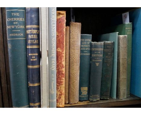
HEDRICK (Ulysses Prentice): 'The Cherries of New York..'; Albany, J. B. Lyon Company, 1915. First edition. 4to, orig. green pub. cloth gilt lettered, a little rubbed and marked, else VG. With frontis & 56 plates. WOODHOUSE (Lionel): 'The Butterfly Fauna of Ceylon..'; Columbo, Ceylon Government Press, 1942. 4to, orig. blue cloth gilt, a little rubbed and scuffed. With 51 plates & one folding colour map; together with eleven other volumes, natural history. (13)

Lot 300
PRIESTLEY (Joseph): 'Historical Account of the Navigable Rivers, Canals and Railways Throughout Great Britain, as a Reference to Nichols, Priestley & Walker's New Map of Inland Navigation..'; London, Longman Rees et al, 1831. First edition; large paper copy. 4to, orig. cloth boards with printed label, binding loose and frayed with the frontis detached and contents shaken and spotted; WEINTHAL (Leo): 'The Story of the Cape to Cairo Railway..'; London, (1923-26), three vols. only, large 4to, orig. half morocco gilt, rubbed and with some damp marking to the boards; together with a quantity of other railway reference and history, 19th and 20th century, various sizes, formats and condition. (Quantity: six shelves)
Lot 316
HOLLINGSHEAD (John, of Chorley) (?): 'A Cursory View of a Proposed Canal: from Kendal to the Duke of Bridgwater's Canal, Leading to the Great Manufacturing Town of Manchester..'; no imprint or date, London (?), 1769, 12mo, period quarter calf, disbound, upper board detached, 56 p.p., with folding frontis map dated 1869. Early manuscript attribution of the work to John Hollingshead at base of title, dated in same hand at head, March 1771. Rare. (1)
Lot 317
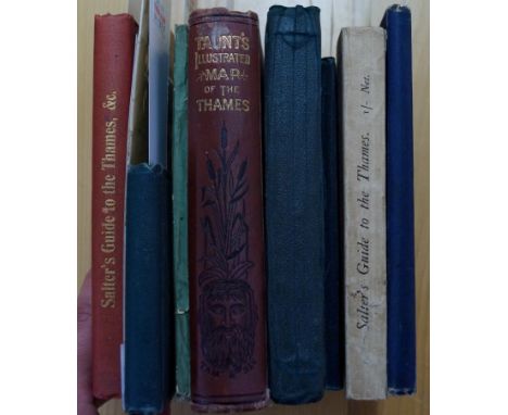
THAMES GUIDES: SALTER (J.H.): 'The River Thames: A Guide to the River and the Principle Places on the Banks, from its Source to Wandsworth..'; Oxford, John Salter, circa 1880, 12mo, orig. blue pub. cloth gilt, a little rubbed, else a good copy; TAUNT (Henry W.): 'A New Map of the River Thames, from Thames Head to London..'; Oxford, printed by the author, circa 1880. Third edition. 12mo, pub. green blind stamped cloth, gilt title to upper; with tipped-in photographic plates, contents shaken with a few leaves loose, covers rubbed and a bit mottled from damp; together with seven other Thames Guides and related 19th, early 20th century, to include: a map of the Thames by Bacon; and two other editions of the second named item. (9)
-
109182 item(s)/page