We found 109182 price guide item(s) matching your search
There are 109182 lots that match your search criteria. Subscribe now to get instant access to the full price guide service.
Click here to subscribe- List
- Grid
-
109182 item(s)/page


Lot 370
LOW COUNTRIES -- "BELGII pars septentrionalis communi nomine vulgo Hollandia nuncupata continens statum potentissimæ Batavorum Reipublicæ seu Provincias Reipublicæ VII Foederatas". Nürnberg, J.B. Homann, (after 1729). Attractive engr. map in cont. handcolouring. 480 x 570 mm. (Small rep. on v°, but in fine condition). NOTE:With large inset maps of the Northeastern US and Southeast Asia and additional vignette views of New Amsterdam (New York) and Batavia (Jakarta). - V.d. Heijden/Blonk, 58 (5th state).

Lot 372
LOW COUNTRIES -- "BRABANTIA DUCATUS/Tabula Ducatus Brabantiae Continens Marchionatum Sacri Imperij et Dominium Mechliniense Magna cura edita a Nicolao Iohannis Visscher". (Amst.), 1657. Cold. engr. map of Brabant, surrounded on all sides by town views, costumed figures, portraits and coats of arms. 470 x 565 mm. (Margins short, several (small) repairs on v°, small irregularities visible on central vertical fold, but an acceptable copy). NOTE:Handsome map with city views in upper and lower border of Louvain, Brussels, Antwerp, 's Hertogenbosch, Tienen, Bergen op Zoom, Lier, Helmond, Breda and Mechelen; left and right borders with costumed figures, together with coats of arms and portraits. - Schilder 6, 58.10.


Lot 1004
GEOGRAPHISCH-TONEEL, Of uitgezochte kaarten, Tot gemak der Officieren, Reisigers en Liefhebbers. Amst., B. v. Gerrevink & Erve Ratelband, 1747. 16 pp. W. 41 fold. (some lge. fold.) maps, all cold. by hand & engr. fold. "Steedewyzer". Tall-8°. Cont. h. goatskin. (Spine a bit rubbed, paper on sides worn/partly gone, 1 map in 2 pieces, some maps split on folds, slightly browned/foxed in places). NOTE:Very rare pocket atlas. Not in Koeman, but similar to Koeman III, p. 99 (Rat 1) of which our atlas is a later edition.
Lot 981
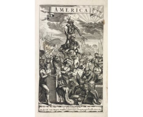
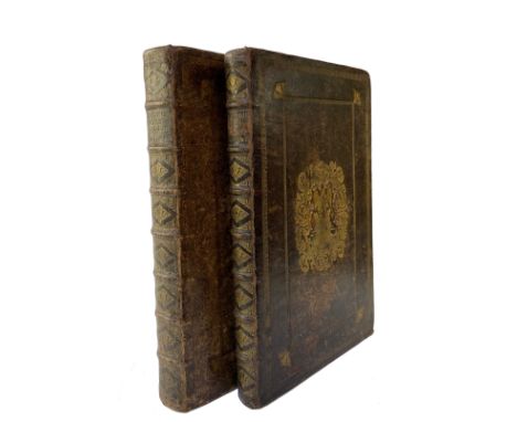
AMERICA -- MONTANUS, A. De Nieuwe en Onbekende Weereld: of Beschryving van America en 't Zuidland, Vervaetende d'Oorsprong der Americaenen en Zuidlanders, gedenkwaerdige togten derwaerds, (…). Amst., J. Meurs, 1671. W. engr. ti., 16 double-p. maps (incl. the fold. map of the Americas), 1 engr. portr. of the dedicatee John Maurice Prince of Nassau-Siegen, 5 (of 6) engr. portraits of the explorers, 30 (of 32) double-p. views and 70 engr. in text. Fol. Cont. cf. w. raised bands, dec. gilt back, gilt floral design on both sides. (Spine rep./reinforced, new endpapers, three plates lacking, last 2 lvs. in photostat, upper outer corner of last 29 lvs. repaired (with small parts of 1 map lacking, part of 1 text-engr. and of 4 text-lvs. in photostat), some (marg.) stains, a bit browned/foxed in places). NOTE:Highly important and scarce work on the Americas divided in three books: the first describing the life and the adventures of the first explorers (Columbus, Vespucci, Magellan, Atahualpa, Montezuma and Pizarro); the second is a description of North America, including many pages on New Netherland, and the third is devoted to South America, including a long chapter on Brazil. First edition, including the famous view on New Amsterdam/New York on p. 124 ("(…) the handsomest, and at the same time the most agreeable view of Dutch New York", Asher, p. 23). Borba de Moraes, 586: "It is incontestably a beautiful book, profusely illustrated, which has become quite scarce in the few last years." The author, Arnoldus Montanus (c.1625–1683) headmaster of the Latin school at Schoonhoven, compiled the book from other sources ("uit veelvoudige schriften bekend") as is mentioned in the dedication by the publisher. - Plates lacking: portait of Montezuma, the God Vitziputzli and view of Potosi. - Tiele 763; Asher 14; Sabin 50086; Palau 177491; Muller 1012; Leclerc 1026. - Sold w.a.f., not subject to return.

Lot 613
SPIES, W. Schönheit & Reichtum des Lebens. Walter Spies (Maler & Musiker auf Bali 1895-1942). Eine Autobiographie in Briefen mit ergänz. Erinnerungen ges. & hrsg. v. H. Rhodius. The Hague, (1964). 601 pp. W. 1 fold. map, 17 tipped in cold.- & 87 plain plates, & some tipped-in or.-photogr. Lge-8°. Ocl. w. dust-j. -- Added: K.D. HÖHN. The Art of Bali. Reflections of Faith. The History of Painting in Batuan, 1834-1994. (Wijk & Aalburg, 1997). 202, (2) pp. Lge-4°. Or. pictorial hcl. -- (2).
Lot 897
BIBLES -- BIBLIA NEERLANDICA -- (MARTIN, D.). Historie des Ouden en Nieuwen Testaments. (Vert. d. W. Séwel). Amst., P. Mortier, 1700. 2 vols. (18), 282, (8); (26), 163, (11) pp. W. 2 variant engr. fronts., lge. engr. vign. on each ti., 32 engr. head- & tailpieces, 5 engr. double-p. maps (incl. a world map & 3 indexes) & 214 engr. plates (141 to the Old & 73 to the NT) w. c. 428 illustrations. Lge-fol. Cont. full cf. w. raised bands, richly dec. gilt backs, large gilt dec. centerpieces (w. angel) on all sides, surrounded by 2 gilt dec. borders. (Binds. a bit rubbed, corners bumped/worn, ti-p. vol. 1 torn (in 2 pieces), a few tears, a few marg. stains, else a fine and clean set with ample margins). NOTE:So-called 'Grote bijbel van Mortier'. One of the finest illustrated bibles produced in the Netherlands with engravings after Luyken, Picart, Goeree, Tideman, Hoet by Baptist, Blois, Mulder a.o. On this luxurious bible cf. Van Eeghen/v.d. Kellen 351; Klaversma/Hannema 180, 187; Poortman II, 98-105.
Lot 443
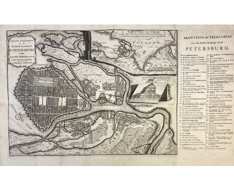
RUSSIA -- GROND-TEKENING van de Russische hoofdstadt St. Petersburg door Czaer Pieter de Eerste In 't Jaer 1703 aengelegt. Utr., J. Broedelet, (1705). Plain, fold. map with inset map of the river Neva. 286 x 390 (=map size). (Some minor foxing). Uncommon. -- KAERT van het geheele Russische Keizerryk Mitsgaders Groot en Klein Tartaryen. Utr., J. Broedelet, 1743. Plain, fold. map. 546 x 495 mm. (Slightly browned/foxed). -- (2).

Lot 1068
GEEST, W. de. Het kabinet der statuen. Amst., J. Lamsveld, 1702. (32), 156 pp. W. engr. ti., 83 engr. on 24 plates (incl. 1 fold. engr.) & 1 fold. map of Rome by J. Lamsveld. Cont. hcf. (Spine ends a bit dam., spine rubbed, paper on sides partly rubbed/affected by humidity, outer margin leaf A2 and fold. map of Rome clumsily rep., tear in fold. engr., faintly waterstained in places). NOTE:Sold w.a.f., not subject to return.
Lot 340
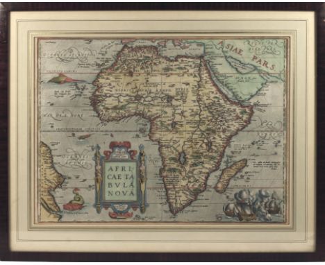
AFRICA -- "AFRICÆ TABULA NOVA". Antwerp, (Ortelius), 1570 (i.e. 1580's/early 1590's). Engr. map by F. Hogenberg, beautifully cold. by a cont. hand. 376 x 507 mm. Framed, glazed and under passepartout. (Uninspected out of frame, but apparently in very good condition). NOTE:Beautiful map decorated with a large cartouche with 2 caryatids, sea monsters and a sea battle in the right lower corner. - Van den Broecke 8; V.d. Krogt 8600:31. To be dated after 1581 and before 1595.


Lot 98
Abraham Ortelius,Descriptio Germaniae Inferioris,hand-coloured map,37x50cm.From Ortelius' Theatrum Orbis Terrarum, the first modern atlas of the world.Condition report:Good condition, not laid down, colours fairly good, mounted very close to the plate mark so unsure of margins, modern frame and under glass.

Lot 99
John Speed,Middle-Sex, described with the most famous cities of London and Westminster,hand-coloured map,38x51cm.Condition report:Good condition, not laid down as glazed to the rear showing text, no holes or tears, colours are quite good, mounted very close to the plate mark so unsure of the margins, framed under glass.

Lot 664
Wales. Ortelius (Abraham) Cambriae Typus Auctore Humfredo Lhyudo Denbigiense Cambrobritano, a double page copper engraving map c/.1600 with hand colouring, strapwork cartouche top left corner, mounted, framedwithin mount 40 x 53 cm., overall 54.5 x 67 cm.Condition: Overall fair. Paper has overall toning,. light creasing

Lot 665
Ulster. Mercator (Gerard) and Hondius (Jacodus) Ultoniae Oritentalis Parsan early 17th century double page copper engraving map, uncoloured, strapwork cartouche bottom right, mounted framedwithin mount 40 x 43 cmCondition: Short tear along fold top margin edge which has been repaired but adhesive has reacted with the paper. Slight creasing, very occasional marginal spotting

Lot 217
FRENCH SCHOOL (CIRCA 1830)SKELETON STUDIESPen and sepia inkExtensively inscribed (lower edge)20 x 15cm (7¾ x 5¾ in.) (5)Together with four other works comprising: English School (circa 1860), Design for bracelet with formed letters, Gouache; English School (circa 1860), Design for a brooch or pin, Gouache; English School (circa 1840), Map of the Ottoman Empire, Watercolour; Pierre La Virgne (circa 1720), Various sizes (5)


Lot 201
Brabner, JHF (edit): The Comprehensive Gazetteer of England and Wales, 6 Vols. W Mackenzie, no date (1892); original pictorial cloth gilt; rubbed; HUGHSON, David [ie PUGH, David & or Edward]: London; being an accurate History and Description of the British Metropolis and its Neighbourhood, to Thirty Miles extent, 6 volumes. V-1 & 2: J Robins & Sons, no date; V-3-6, J Stratford, 1806-1813. WITH ONLY 2 FRONTIS PLATES & A FOLDING MAP IN VOL.5; LACKING ALL THE PLATES; A/F; Luckombe, P: England’s gazetteer in 3 vols. Robinson 1790, with a folding map to vol.1. Later cloth; worn, titles to vols. 2 & 3 taped to the covers; A/F; (15)

Lot 207
1- Philips' handy-volume Atlas of London. Nd, c1928, 9th. Edn. Enlarged. With 72 colour maps (mostly double-page), + index. Original cloth, recased with new epps and special clamshell box.; 2- Robertson: Topographical map of the Great Road from London to Bath and Bristol with the Country three miles wide on each side, 1792. Sheets 1 - 11 (excluding sheets 1 & 9). Loose in a recent clamshell box; 3- Walker: Somersetshire, 1842. (400 x 320). Folding, coloured and linen backed. Recent clamshell box; 4- Pinnock: Country histories: Somersetshire. Whittaker, 1824. With a folding map and 72pp of text, disbound and now in a recent clamshell box. (4)Provenance: From a private Somerset map collection.


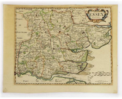
Lot 237
Collection of Maps: Bowen, E: An accurate map of the county of ESSEX divided into its hundreds. R Wilkinson, no date, c1780. Hand-coloured, with an engraved view; CARY: Map of ESSEX, no date. Hand-coloured (400 x 340); & Map of CAMBRIDGESHIRE from the best authority. Stockdale, 1805. Hand-coloured and folded (500 x 400); MORDEN: Map of ESSEX, no date. Hand-coloured (400 x 340); Plus: Greenwood: Map of the county of HERTFORD from an actuarial survey, 1830-31. Engraved by J & C Walker, April 1st 1834. Hand-coloured and with a view of St Albans, (730 x 580) (5)

Lot 238
1- Drayton: Somersetshire and Wiltshire. 1613. (335 x 251), mounted; 2- Smith: New Map of the county of Somerset, Dated Jan. 1801. (503 x 442), hand coloured and mounted; 3- Walker: Somersetshire. 1835-7. (394 x 323), hand coloured and mounted; 4- Wallis: Somersetshire: 1810-2, ( 95 x 133), hand coloured and mounted; PLUS 3 Others (2 coloured), and all mounted (7)Provenance: From a private Somerset map collection.

Lot 242
BRISTOL CHANNEL: 1- Collins: The Severn or Channell of Bristoll. 1693-1792, (560 x 440), hand-coloured and mounted; 2- Halley: A Draught of the Bristol Channel from the Holmes to King Road including the River Avon. Taken from Capt. Holliday's Survey of the said River kept in ye Merchants Hall at Bristol. 1728, (547 x 457), mounted; 3- Fullarton: Bristol Channel. 1875, (235 x 140), hand-coloured and mounted (3)Provenance: From a private Somerset map collection.

Lot 244
1- Tunnicliffe: A New Map of Somersetshire. 1791. (568 x 428), hand coloured & mounted; 2- Reynolds: Dorsetshire, Somersetshire and South Wiltshire. 1904. (253 x 182), hand coloured & mounted; 3- Bickham: A Map of Somersetshire. 1749-54. (145 x 250), mounted; PLUS 2 Others (1 coloured), and all mounted (5)Provenance: From a private Somerset map collection.

Lot 247
CITY OF BATH: 1- Dury: Plan of the City and Suburbs of Bath. 1766 (130 x 110), hand-coloured and mounted; 2- Meijer: Nieuwe Grondteekening van de stad Bath. c.1763. (194 x 125), mounted; 3- Moule: The English Counties delineated: City of Bath, 1834 (195 x 270), hand-coloured and mounted; 4- The Bath and Bristol Magazine: An Accurate plan of the City of Bath. 1776 (167 x 215), hand-coloured and mounted; PLUS 5 Others (2 coloured), and all mounted (9)Provenance: From a private Somerset map collection.
Lot 547
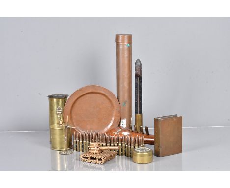
A selection of Trench Art and related items, to include a small shell with additional wooden thermometer, a caddy, a small container with Welsh Dragon to the top, a Souvenir de Arras 1918 plate, with hand engraved message to reverse, a belt of inert rounds, a converted butt of a rifle to a decorative stand, a 1951 map tube and more (parcel)

Lot 586
A collection of military ephemera, to include a 1940 Daily Express, a silk map of France, Public information leaflets, reproduction identity and ration cards and more, plus three reproduction WWII propaganda posters 'Keep Mum She's Not Dumb', 'Let's Go Forward Together', and 'Dig On For Victory' (parcel)


Lot 306
Biblia. Novum Jesu Christi Testamentum, woodcut device to title, early dark red calf, spine gilt, 16mo, Antwerpiae: Ex officina Christophori Plantini 1567,L. Guicciardino - Belgicae sive Inferioris Germaniae Descripto, engraved title, folding map and d.p. town plans, contemporary vellum, Amstelaedami: 1660, The Ladies' Monthly Museum or Polite Reposition, vol IX (only), hand coloured fashion plates, lacks cover, London 1819, A Hand-book for Visitors to Oxford, wood engravings, half calf, by J Kelly, Oxford 1847 and three others (7)
![Americana. An 18th c American-engraved powder horn, inscribed John Smith His horn maed [sic] Sept the 30 1767, with a ma](https://cdn.globalauctionplatform.com/9863aa83-d3b9-4d50-8f3a-ae8600e353fc/ac98859a-e7bc-42a2-abb7-ae860102d87e/468x382.jpg)
Lot 475
Americana. An 18th c American-engraved powder horn, inscribed John Smith His horn maed [sic] Sept the 30 1767, with a map of the route from New York to St John and to Fort Ontario and Niagara, with royal arms, views of London, New York, Quebec, small settlements, forts, hills, a windmill and column of foot soldiers and grenadiers, 39.5cm l measured straight Old dirt and slightly chipped but no substantial damage, no restoration

Lot 644
Trade card related, Whitbread Inn Signs, Whitbread Metal Map, East Kent, a privately commissioned metal map being a copy of Whitbread's original metal version, printed on aluminium & the same size as the original, 82.55cm x 57.15cm. Ideal for display purposes as the originals tend to fade. (vg)

Lot 645
Trade card related, Whitbread Inn Signs, Whitbread Metal Map, West Kent & East Sussex, a privately commissioned metal map being a copy of Whitbread's original metal version, printed on aluminium & the same size as the original, 82.55cm x 57.15cm. Ideal for display purposes as the originals tend to fade. (vg)


Lot 1140
Postcards, a collection of approx. 82 cards of the condominium of Crete in modern album, with map card, stamp card, postal stationary, religious leaders, views of Crete, ethnic, Italian Mission, costume, groups, market, various villages, farming, harbour, Rogdia (village), a few postally used. Sold with 'A Postal History of Cretan Administration 1900-1913' (mainly gd)

Lot 386
Transportation Photographs and Ephemera to include 250+ vintage photographs depicting cars, buses and coaches, trains, motorbikes, bicycles, horse drawn transport, AA, charabancs, 1937 Cowley Works, S.M. Soundy & Son Reading steam lorry etc. together with a quantity of 1930s to 50s driving licences, fuel ration books, Highway Codes, 1920s Dunlop accessories price leaflet, blotters, tickets, menus, club rules booklet, Isle of Man TT and other stickers, Isle of Man TT 1970 programme with map (gen gd) (350+)


Lot 727
A BOX AND LOOSE METALWARES, ETC, including a silver plated oval entree dish and cover, silver plated coffee pot, hot water jug and tea pot, not matching, Indian brass jardiniere, a cased pair of EPNS napkin rings, six Royal Worcester egg coddlers, a small quantity of folded maps including Bacon's New Pocket Map of Birmingham, etc (1 box and loose)


-
109182 item(s)/page