We found 109198 price guide item(s) matching your search
There are 109198 lots that match your search criteria. Subscribe now to get instant access to the full price guide service.
Click here to subscribe- List
- Grid
-
109198 item(s)/page

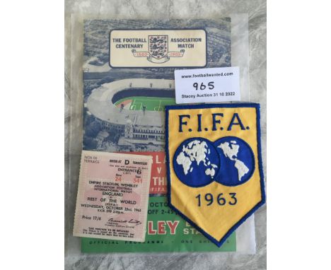
Lot 965
1963 Football Association Centenary FIFA Cloth Badge: Issued to East Germanys Rene Courte who attended the famous England v Rest of the World match. States FIFA 1963 with a map of the world and was the same badge used on the shirts for the Rest of the World team. C/W programme and ticket for match.


Lot 1221
Franz Ackermann (Neumarkt St. Veit/Bayern 1963 – lebt in Berlin). „The Foot Court“. 1998Mischtechnik auf Papier. 12,9 × 19 cm (5 ⅛ × 7 ½ in.). Auf der Rückpappe ein typografisch bedrucktes Etikett mit den Werkangaben: untitled (mental map: the foot court) 1998 mixed media on paper 13 x 19 cm. Sowie ein Stempel der Galerie Neugerriemschneider, Belrin.Ein Blatt der Folge: Mental Map. [3523]Zustandsbericht: Schöner harmonischer Gesamteindruck. Die Blattkanten ohne Einrisse oder Fehlstellen. Das Papier montierungsbedingt leicht gewellt. Unter UV-Licht sind keine Retuschen oder Restaurierungen erkennbar. Rückseitig in den Ecken mit Flüssigkleber auf den Unterkarton montiert.Wir berechnen auf den Hammerpreis 25% Aufgeld und auf Hammerpreis und Aufgeld die zum Auktionszeitpunkt geltende Umsatzsteuer.

Lot 1220
Franz Ackermann (Neumarkt St. Veit/Bayern 1963 – lebt in Berlin). „Anonymous Park“. 1997Gouache, Bleistift und Papierklebestreifen auf Papier. 13 × 19 cm (5 ⅛ × 7 ½ in.). Rückseitig bezeichnet, betitelt und datiert: "Mental Map: anonymous Park" 97.Ein Blatt der Folge: Mental Map. [3523]Zustandsbericht: Schöner harmonischer Gesamteindruck. Die Blattkanten ohne Einrisse oder Fehlstellen. Das Papier leicht gebräunt und mit vereinzelten winzigen Fleckchen. Montierungsbedingt in den Ecken leicht gewellt. Unter UV-Licht sind keine Retuschen oder Restaurierungen erkennbar. Rückseitig in den Ecken mit Papierklebeband auf den Unterkarton montiert.Wir berechnen auf den Hammerpreis 25% Aufgeld und auf Hammerpreis und Aufgeld die zum Auktionszeitpunkt geltende Umsatzsteuer.

Lot 266
Year: 19th CenturySize: 59" x 32" Medium: OilDescription: Large 18th/19th century world map from Vopel's lost world map of 1545 flanked by explorers Columbus and Magellan, tempera on canvas. Excellent detail and colour, would be enhanced with restoration of the small loses. Framed. Measurements: 59" x 32" framed approx


Lot 117
c1910/11 Metropolitan Electric Tramways pocket MAP OF ROUTES and Particulars of Services. Includes the "Middlesex and Hertfordshire Light Railways" in the cover title, these being operated by the MET. Shows the company's services linking to the Underground railways. Opens out to 8.5" x 10" (22cm x 25cm). In very good condition, two small filing punch-holes near one edge. [1]
Lot 134
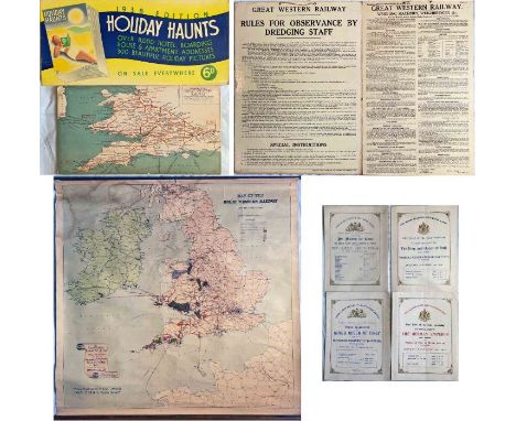
Selection (9 items) of Great Western Railway (GWR) items comprising 2 CARRIAGE PRINTS on thick card: c1920s Diagram Map & 1938 'Holiday Haunts' advert (good, ex-use condition), pair of 1920s/30s laminated card WORKPLACE NOTICES: Rules for Dredging Staff and Weighing Machines/Weighbridges (very good condition), a c1910 office, roll-up WALL MAP of the system showing coal-producing & other mineral areas (some wear & staining) plus a GWR snap-binder containing Royal Train TIMETABLE CARDS dated 1893, 1903, 1903 & 1907 (very good condition). [9]
Lot 137
1911 London Underground POCKET MAP. This edition shows the 3 separate Hammersmith stations, the CLR extension to Liverpool St under construction and the LBSCR lines to Crystal Palace. Ex-guidebook example with scuffs, very small losses and very short tear at the r/h edge and subsequently re-folded. Opens out to 10.5" x 8" (27cm x 20cm). [1]

Lot 139
1893 District Railway MAP "District Railway & Connections". Shows the company's lines in red and all other London railways duly colour-coded with a reference index. Produced by "District Railway, Manager's Office, March 1893" and printed by Waterlow & sons. Presumably produced for company offices and stations etc. Not seen by us before. Opens out to 26" x 21" (66cm x 53cm) and is in very good condition with light wear. [1]

Lot 141
Selection (6) of District Railway ephemera comprising TIMETABLE BOOKLETS dated June 1873 (fragile, loose covers) and May 1906 (electric trains, map on reverse), c1906 small fold-out CARD with pop-up 'Ealing Non-Stop Service' with illustration of new electric car, 1914 BROCHURE 'Pleasure Outings on the District Railway' with cover illustration by Mabel Attwell (wear to partially loose cover), 1915 BOOKLET 'Pleasure Outings' with cover illustrations by Holdsworth (very good cond) and 1921 small card LEAFLET 'First & Last Trains' (very good condition). [6]

Lot 142
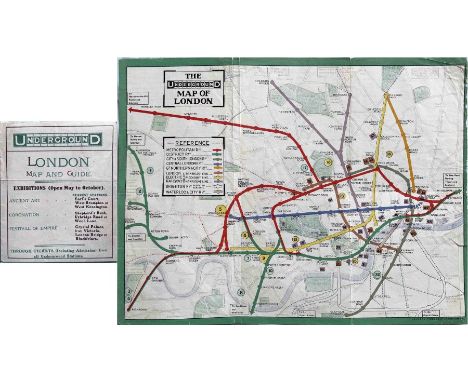
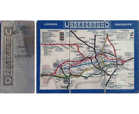
Selection (3) of early London Underground ephemera comprising 1909 STREET & RAILWAY MAP (54pp incl colour map & 'No Need to Ask a P'lceman' cartoon), 1915 BOOKLET 'Alphabet of TOT (Train-Omnibus-Tram)' with lavishly coloured illustrations by Chas Pears, one for each letter, and 1925 BROCHURE 'The Open Gate to the Country - School & Pleasure Parties' with strong cover image of escaping the smoke of the factories for the countryside. The first has some cover wear, otherwise all are in very good condition. [3]

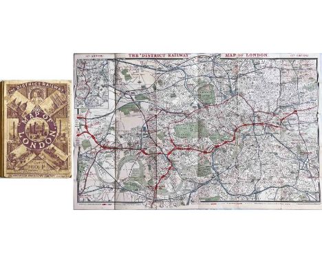
Lot 146
1887 District Railway MAP OF LONDON, Jubilee Edition, produced for Queen Victoria's golden jubilee. An early London Underground map showing the District Railway, the Metropolitan Railway and including the recently-completed Inner Circle line. Lines over which the District ran are shown in red or blue/red, other railways in blue. Paper map inside cloth covers, opens out to 42.5" x 26" (108cm x 66cm). A very reasonable copy with some partial fold partings. [1]
Lot 147
c1911 London Underground linen-card POCKET MAP. Issued by the Metropolitan Railway and promoting the company's "City & St John's Wood Line". This was a standard Underground Group map which, in this case, they also made available to the Met who put their own publicity on the reverse. Features the UndergrounD logo vertically on the cover. Generally, in good condition with light wear, age-darkening to the covers and the first user's signature on the front. [1]

Lot 152
Selection (3) of 1920s Metropolitan Railway MAPS "of Extension Lines into Metro-Land", each backed with a map of central London also showing the District and tube railways. There are detail differences between the three, they are undated but one is from 1924 as it shows the British Empire Exhibition site at Wembley. The maps also show golf courses, new residential estates etc along the railway. Maps are ex-guidebooks and open out to 19" x 15" (48cm x 38cm). All are in lightly-used condition but generally good. [3]


Lot 156
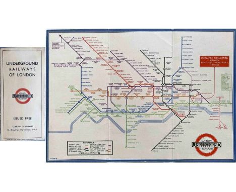
Very large quantity (250+) of London Transport etc 1920s-70s LEAFLETS including Holiday Services (c30), Cheap Fares, Green Line timetables, Red Arrow maps, route changes etc (c70), Night Bus timetables (18), Buses for Trams/Trolleybuses (24) and pocket map Amendment Leaflets (c120).Some are well used but most are good to very good. [250+]

Lot 158
1951 London Underground Metropolitan Line CAR DIAGRAM from compartment stock, mounted and glazed in original-style wooden frame. Size: 25.5" x 9.5" (65cm x 24cm) with frame. Map has vertical creases and some water ingress from the lower edge but is generally in very reasonable, ex-use condition. [1]

Lot 164
1924 Metropolitan Railway small POCKET CARD MAP "How to get to and from the British Empire Exhibition". Illustrated with a new electric locomotive on the cover, this is the Met's version of an Underground pocket map but highlighting its own lines in red with the District Railway and the Tubes in blue. Opens out to 5.75" x 4.5" (15cm x 11cm). This is the orange cover version. In excellent condition. [1]


Lot 175
Selection (3) of early RAILWAY EPHEMERA comprising 1913 Great Northern Railway Timetable "London to North of England & Scotland" (19pp booklet in excellent condition), 1903 Great Southern & Western Railway (Ireland) "Tours in the Sunny South" (17pp illustrated brochure with centre-fold map, in vgc) and 1932 Southern Railway fold-out timetable leaflet "Main Line Electrification - Redhill, Reigate, Horley, Three Bridges" (good condition with some wear). [3]
Lot 2
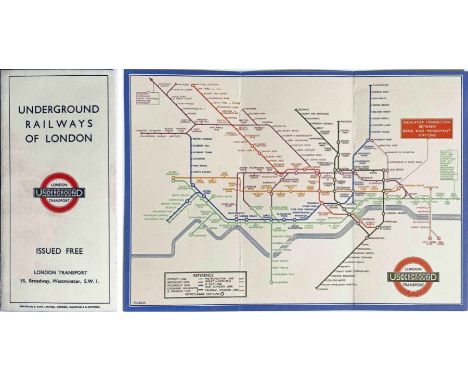
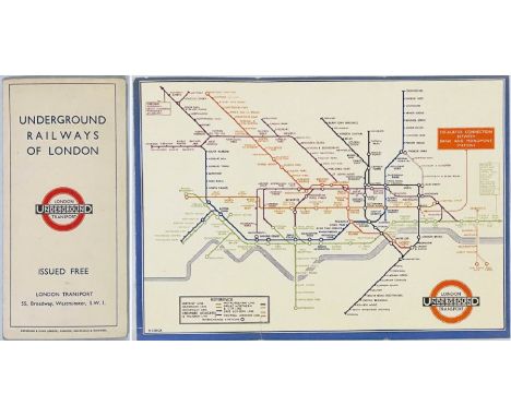
1933 London Underground H C Beck diagrammatic, card POCKET MAP from the first-year series titled 'Underground Railways of London'. Issued c.September 1933 and has print reference 33-2791. Shows the escalator connection between Bank and Monument stations. Generally in very good condition with light wear and a very short fold-parting from lower edge. [1]

Lot 202
c1948-50 London Transport quad-royal POSTER MAP "Central Bus Routes" (undated but just before the merger with the Trolleybus & Tram Dept). These were posted at Underground stations and in bus shelters. Generally in very good condition with very small fold-corner partings, a little age-darkened. Folded. [1]
Lot 204
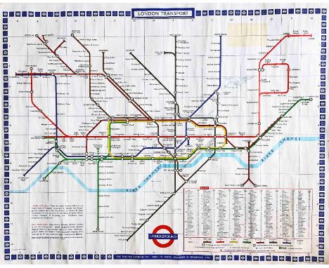
1967 (print-code 11/67) London Underground quad-royal POSTER MAP designed by Paul Garbutt with the classic border of small bullseyes. Interchange stations are in upper case, the remainder in lower. Shows the Victoria Line as 'under construction' from Victoria to Walthamstow, Hoe Street but, otherwise, the network is still in its settled post-war state. Generally in very good condition, a little creasing, some very small edge nicks and a stain where there was once a sticker between Cockfosters and Theydon Bois [1]

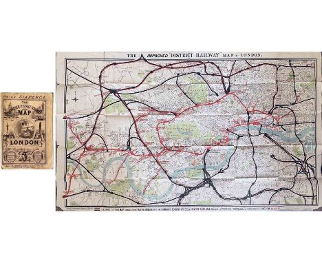
Lot 217
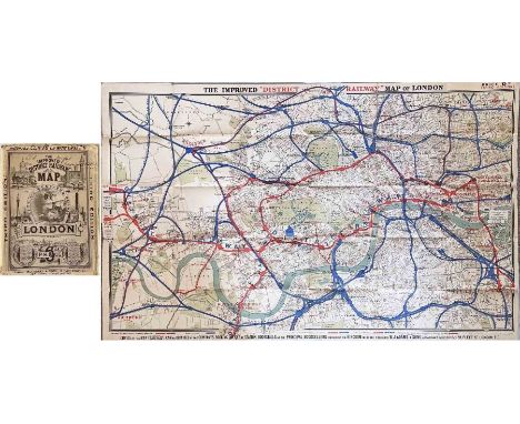
1884 'Improved' District Railway MAP OF LONDON, 3rd edition. A very early Underground map showing the first lines: the District, Metropolitan Railways and the Inner Circle line which was completed that year. Lines over which the District ran are shown in red, other railways in blue. Interesting overprints are the International Health Exhibition at Exhibition Road and, at South Kensington "Authorised South Western Ry West End station". Linen-backed inside cloth covers. Opens out to 42" x 26" (106cm x 66cm). Some wear & annotations on covers, the map is in very good condition. [1]
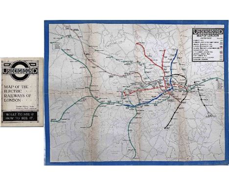
Lot 227
1919 London Underground MAP OF THE ELECTRIC RAILWAYS OF LONDON 'What to See & How to See it' with print-code 209-500M-18-6-19. Has the black bullseye on the cover and opens out in 8 panels to 14" x 11" (35 x 28cm). This is a very good copy, just a trace on the spine where it was once tipped into a guidebook. [1]
Lot 238
1933 London Underground H C Beck diagrammatic, card POCKET MAP from the first-year series titled 'Underground Railways of London'. Issued c.September 1933 and has print reference 33-2791. Shows the escalator connection between Bank and Monument stations. In very good condition with just a little age-darkening to the cover. [1]

Lot 244
1920s Metropolitan Electric Tramways ENAMEL SYSTEM MAP. These would have been displayed in Underground stations. Shows this Underground Group company's network in NW London together with Underground railways, connections to the associate London United Tramways' services and through running over LCC tracks into central London. Measures 29" (73cm) square. Two small, well-executed repairs at the top and a few minor blemishes but in very good condition overall with an excellent shine. Unusual to see in such good condition. [1]
Lot 253
Pair of 1909 London Underground POCKET MAPS 'What to See and How to See it, The Excursionists' Guide with Map'. These are the issue with numbers referring to points of interest listed on the reverse. Open out to 10.5" x 8.5" (27cm x 22cm). Ex-guidebook copies, folded as such, and with edges trimmed by the printer. Lightly used but generally in very good condition. [2]

Lot 254
1949 London Underground Metropolitan Line CAR DIAGRAM from compartment stock, mounted behind acrylic in original-style wooden frame. Size: 25.5" x 9.5" (65cm x 24cm) with frame. Map has vertical creases and some small stains/blemishes but is generally in very reasonable, ex-use condition. [1]
Lot 259
1933 London Underground H C Beck diagrammatic, card POCKET MAP from the first-year series titled 'Underground Railways of London'. This is the edition with no print-code, issued c. August 1933 and has 'LPTB' inside the bullseye logos. Refers to re-naming of Dover St station to Green Park and the merger of Holborn and British Museum stations, all in September that year. An excellent example, crisp, firm and unmarked. [1]

Lot 263
1909 London Underground HANDBILL MAP for the Inner Circle Service 'Metropolitan & District Railways, Inner Circle Line - Connecting link between all the trunk railways'. We think this may well be the first piece of publicity for the service, some 40 years before it was officially named today's Circle Line. Features an early example of the UndergrounD logo. Issued jointly despite the Met not being a part of the Underground Group. Most uncommon. Measures 8" x 6.5" (21cm x 16cm) and is in excellent condition, one light vertical fold. [1]

Lot 264
c1910 Evening News London Tube Map. The cover depicts a tube train inside tube segments bearing the names of all the tube lines (incl the Waterloo & City and Great Northern & City) although the map gives equal prominence to the sub-surface lines. Produced by The London Geographical Institute (George Philip & Son) in a style later adopted by the Underground itself from 1912. The reverse has a map of London's tramways. Inside card covers and opens out to 24" x 20" (61cm x 51cm). The covers are a little worn, the map itself is very good. [1]
Lot 278
1879 'Improved' District Railway MAP OF LONDON, 1st edition, 3rd variant. A very early Underground map showing the first lines: the District and the Metropolitan Railways. The DR is now open to Richmond with the Ealing and Fulham extensions shown as under construction. The Inner Circle completion and the extension to Whitechapel are shown as proposed. Paper inside cloth covers. Opens out to 42.5" x 25.5" (107cm x 65cm). Map is in good condition with a short fold-parting, edge nicks and small corner losses, a little wear to the covers. [1]

Lot 288
1922 London Underground MAP OF THE ELECTRIC RAILWAYS OF LONDON 'What to See & How to Travel' with issue date 1-3-22. Designed by MacDonald Gill with calligraphed station names, the map opens out to 13.5" x 11" (34 x 28cm). Small, light stains on the map-side, otherwise an excellent example. [1]
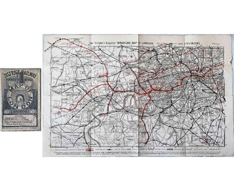
Lot 289
1902 District Railway POCKET MAP 'Pocket Reference Map of London & Environs'. This is a true pocket map rather than a guidebook issue and is double-sided with travel information etc on the reverse. The map itself is the 6th edition of the District Railway Miniature Map of London and Environs. Opens out to 17.5" x 11" (44cm x 28cm) and is generally in very good condition, lightly-used with an edge scuff, cover a little age-darkened. [1]

Lot 327
c1898 London Underground MAP 'The District Railway Map of London', 6th edition, first version. The first tube line, the City & South London, is open from Stockwell to King William St with extensions to Bank and Angel under construction. Also under construction are the Central London, the Euston & Hampstead and the Great Northern & City tubes. The District's extension to Wimbledon is shown by an inset. Linen-backed map in very good condition inside card covers in good condition. Opens out to 42" x 26.5" (106cm x 67cm). [1]

Lot 328
1924 Metropolitan Railway small POCKET CARD MAP "How to get to and from the British Empire Exhibition". Illustrated with a new electric locomotive on the cover, this is the Met's version of an Underground pocket map but highlighting its own lines in red with the District Railway and the Tubes in blue. Opens out to 5.75" x 4.5" (15cm x 11cm). This is the blue cover version. In excellent condition. [1]

Lot 329
c1918/19 London & Suburban Tramways POCKET MAP. Shows the networks of the Underground Group tram companies: LUT, MET & SMET as well as the Underground railways. The tram routes are shown as connecting with the Underground, though other trams - LCC, Croydon etc are ignored! This very scarce survivor is even more unusually linen-backed and folded into card covers, presumably for office or inspectors' use. Opens out to 13.5" x 17" (34cm x 43cm) and is in good condition, a little age-darkened, two punch holes at one edge. [1]
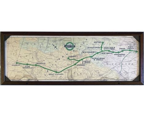
Lot 336
1945 London Underground Metropolitan Line CAR DIAGRAM (map) for compartment stock showing the lines to Watford, Chesham and Aylesbury from North Harrow through the Chiltern Hills. Both the line and the pre-war style LT bullseye are coloured green. Mounted behind acrylic in an original-style frame. Size: 25.5" x 9.5" (65cm x 24cm) with frame. A vertical crease and a little damp ingress at the lower edge but generally in good, ex-use condition. [1]

Lot 337
c1906/07 London Underground POCKET MAP -Great Northern, Piccadilly & Brompton Railway ''Travel to and from the theatres by London's latest tube''. A map of the West End with theatres and tube lines shown. Reverse has theatre and travel information. Only the second example we have seen at auction. In excellent condition with only very minor blemishes. [1]


Lot 375
c1911 London United Tramways pocket MAP OF SYSTEM AND PLACES OF INTEREST ''in connection with the Underground system of London''. The only known LUT public issue. Features the first UndergrounD logo on the map side and lists places of interest, fares, first & last trams etc on the reverse. Opens out to 10.5" x 8.5" (27cm x 22cm). Some light staining on the reverse, but generally in good condition. A rarely-seen map. [1]

Lot 376
c1910/11 Metropolitan Electric Tramways pocket MAP OF ROUTES and Particulars of Services. Includes the "Middlesex and Hertfordshire Light Railways" in the cover title, these being operated by the MET. Shows the company's services linking to the Underground railways. Opens out to 8.5" x 10" (22cm x 25cm). Generally in very good condition, lightly used, some age-darkening on the rear cover. [1]
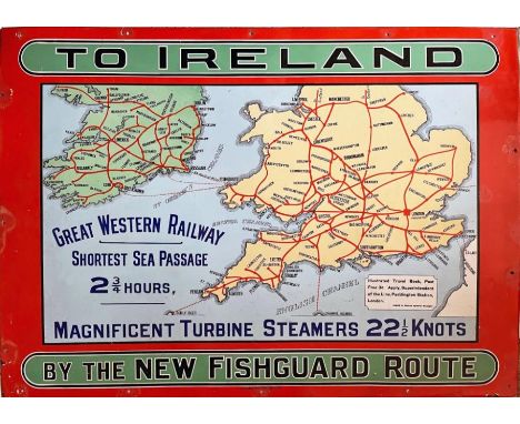
Lot 377
c1906 Great Western Railway (GWR) enamel ADVERTISING POSTER 'To Ireland by the new Fishguard route. Magnificent Turbine Steamers - 22 1/2 knots'. Features a map of the railways in the lower half of England and Ireland with the new sea routes shown from Fishguard to Rosslare, Waterford and Queenstown. Manufactured by Chromo, Wolverhampton and measures 50" x 36" (127cm x 92cm). Generally in very good, ex-use condition with small areas of restoration around the screw-holes. [1]

Lot 38
1910 (September) London General Omnibus Company LIST of Motor & Horse Routes 'including the Sunday Services to the Country, Open Air to Everywhere'. These guides were the predecessor to the London bus map which was introduced the following year. Cover illustration shows an early motor-bus. All routes are listed, divided into horse and motor services. In very reasonable condition, a little fragile, some fold partings repaired with archive tape. [1]
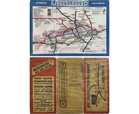
Lot 385
1910 London Underground linen-card POCKET MAP. Issued by the Metropolitan Railway (the 'All Red Route') to promote travel to Wood Lane for the Japan-British Exhibition. This was a standard Underground Group map which, in this case, they also made available to the Met who put their own publicity on the reverse. Features the UndergrounD logo vertically on the cover. We have not seen this particular version before. Generally, in very good condition with some age-darkening & fading to the cover. [1]
-
109198 item(s)/page