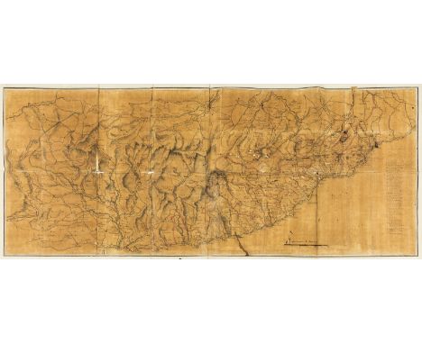

Napoleon.- Anonymous (late 18th century) Manuscript map illustrating Napoleon's campaign across the Apennines, April 1796, showing the coast from Nice to Savona, part of the Piedmontese Apennine Mountains and French Alps, including military positioning and a 33-point key identifying military units and their respective locations, pen and black ink, red ink, wash, on buff laid paper, several sheets joined, with various late 18th century watermarks, neatly pasted onto cream laid paper with double-ruled black ink border, total approx. 450 x 1120 mm. (17 3/4 x 44 in), attached tab that reads 'I.D/ No. 7', and inscribed verso in French 'Huite du positions de l'armée dans la Piedmont', several folds and handling creases, some splitting, small holes and nicks, rough edges, some surface dirt, unframed, circa 1796 and later.⁂ Napoleon's campaign in Italy between 1796-97 established his fame as a military commander. The present map shows in detail how the geography of the Ligurian Apennines was key to Napoleon's early successes, with the commander taking advantage of a gap that ran from Savona west to the southern end of the Bormida valley. Following Napoleon's strategising and several significant battles, General Colli, in command of the Piedmontese army, sued for peace and on 28 April Piedmont withdrew from the war.
We found 109182 price guide item(s) matching your search
There are 109182 lots that match your search criteria. Subscribe now to get instant access to the full price guide service.
Click here to subscribe- List
- Grid
-
109182 item(s)/page

Sardinia.- Jansson (Jan) Insulae Sardiniae Nova Et Accurata Descriptio, detailed map of Sardinia originally published by Jan Jansson, but this impression with the added imprint of Valk and Schenk and additional gridlines, engraving with hand-colouring, platemark 407 x 500 mm. (16 x 19 3/4 in), sheet 485 x 600 mm. (19 x 23 5/8 in), central vertical fold with careful repairs to splitting, otherwise minor surface dirt and light browning, unframed, Valk and Schenk, [Amsterdam, circa 1644-1680].

Spain.- Sanson (Nicolas) & Pierre Mariette. Les Estats de la Couronne de Castille, dans les Parties Plus Meridionales de l'Espagne..., detailed map of southern Spain showing the Strait of Gibraltar and the northern tip of Africa, engraving with some outline hand-colouring, sheet 450 x 595 mm. (17 3/4 x 23 1/2 in), central vertical fold with some minor toning visible, light spotting and browning, unframed, Paris, 1625.

Spain.- Fer (Nicholas de) Les Royaumes de Grenade et d'Andalousie, detailed map of Southern Spain, including the Strait of Gibraltar and part of northern Morocco, engraving with outline hand-colouring, on laid paper with watermark of a rosary, platemark 445 x 480 mm. (17 1/2 x 18 7/8 in), sheet 512 x 600 mm. (20 1/4 x 23 1/2 in), central vertical fold, surface dirt and light browning, unframed, [circa 1707].
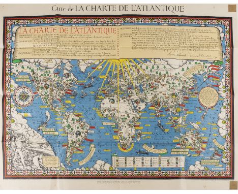
World.- Gill (MacDonald) Carte de la Charte de L'Antique, French edition of Gill's scarce pictorial "Time and Tide" Map of The Atlantic Charter, which was published to celebrate the joint declaration of Churchill and Roosevelt in August 1941, after the Atlantic Conference, colour lithograph on wove paper, sheet 875 x 1140 mm. (34 1/2 x 44 3/4 in), central and vertical folds, some splits with repairs verso, pin holes in the corners from being affixed, the upper and lower right corners with small reinforced areas, some small marginal nicks, surface dirt, unframed, George Philip & Son, 1943.

Spain.- Catalonia.- Homann (Johann Baptist) Principatus Cataloniae nec non Comitatuum Ruscinonensis et Cerretaniae Nova Tabula, map of the Spanish region of Catalonia showing from the Mediterranean coastline to the French border via Barcelona to Tortosa, engraving with original hand-colouring, platemark 490 x 580 mm. (19 1/4 x 22 3/4 in), sheet 515 x 610 mm. (20 1/4 x 24 in), central vertical fold reinforced verso, marginal nicks and tears with repairs verso, printers' crease to lower centre, some surface dirt and browning, unframed, [circa 1720].

West Indies.- Hondius (Jodocus) Mappa Aestivarum Insularum Alias Barmudas..., map of Bermuda from one of the earliest world atlases published by the Blaeu family, the "Atlas Appendix ...", based on the map of Richard Norwood, first published by John Speed in 1627, which proved to be the prototype for other English and Dutch maps throughout the next fifty years, the island is shown beneath a large decorative title cartouche and is divided into 'Tribes' with the landowners listed below, engraving, an excellent impression on laid paper without watermark, platemark 410 x 535 mm. (16 1/8 x 21 in), sheet 495 x 580 mm. (19 1/2 x 22 3/4 in), Latin text verso, two small pin holes in the upper right corner, minor surface dirt and light spotting, unframed, Amsterdam, [circa 1630].

West Indies.- Jefferys (Thomas) St. Lucia Done From Surveys And Observations Made By The English..., map of the island of St. Lucia, from Robert Sayer's "West Indian Atlas", showing the plantations, mountains, rivers, roads anchorages and place names, with an inset chart of "The Carenage", engraving with original hand-colouring, platemark 635 x 480 mm. (25 x 18 7/8 in), sheet 732 x 540 mm. (28 3/4 x 21 1/4 in), central horizontal fold as issued, minor marginal damp-stain in the lower left and centre margins, well outside the map, some light offsetting and surface dirt, unframed, 1775.

British Isles.- Jansson (Jan) Insularum Britannicarum Acurata Delineatio ex Geographicis Conatibus Abrahami Ortelii, map of the British Isles after Ortelius with north oriented to the right, featuring sea monsters, sailing ships, compass roses and rhumb lines, engraving with some hand-colouring, platemark 395 x 510 mm. (15 1/2 x 20 1/8 in), sheet 495 x 590 mm. (19 1/2 x 23 1/4 in), Latin text verso, cental vertical with some repairs, some surface dirty and browning, unframed, [circa 1640].

Great Britain.- Channel Islands.- Blaeu (Willem Jansz.) Sarnia Insula, vulgo Garnsey: et Insula Caesarae, vernacule Jarsey, map showing the islands of Guernsey and Jersey with decorative title and scale cartouches, with sailing ships and a coat of arms, engraving with early outline colouring, platemark 395 x 475 mm. (15 1/2 x 18 3/4 in), sheet 480 x 575 mm. (18 7/8 x 22 3/4 in), French text verso, central vertical fold as issued, some spotting and surface dirt, particularly to lower margin, unframed, [circa 1645].

Great Britain.- Moll (Herman) A New Map of Great Britain according to the newest and most exact observations, large detailed map of Britain, with an inset map of the Shetland Islands, picture frame title cartouche and compass rose in the lower left quadrant, engraving on two sheets joined, outline hand-colouring, sheet 1045 x 650 mm. (41 1/8 x 25 1/2 in), some careful repairs to splits and to marginal loss at extremities of horizontal folds, expertly repaired tear in the lower left quadrant, minor handling creases and browning, unframed, [circa 1717-1732].

England.- River Thames.- Jaillot (Alexis-Hubert) Carte de l'Entree de la Tamise avec les Bancs, Passes, Isles et Costes Comprises Entre Sandwich et Clay, sea chart of the eastern coastline of England with north orientated to the east, including Norfolk, Suffolk, Essex, and Kent, showing the Isle of Thanet to Sheringham, with an inset map of the River Thames from its estuary to London, engraving, a good impression on laid paper, two sheets joined, total platemark approx. 460 x 900 mm. (18 1/8 x 35 1/2 in), wide margins, the upper and lower margins folded, minor surface dirt, unframed, [circa 1693 or slightly later].

England & Wales.- Visscher (Nicolas) A New Mapp of the Kingdome of England, Representing the Princedome of Wales and other Provinces, Cities, Market Towns..., map of England and Wales, with two tables, now detached, presented in one mount, engraving with hand-colouring, total approx. 610 x 820 mm. (24 x 32 1/4 in), some cracking and browning to right edge of the map sheet, with repaired nicks and tears, otherwise light browning and surface dirt, unframed, John Overton, [circa 1695].

Ireland.- Ortelius (Abraham) Eryn. Hibernaie, Britannicae Insuale, Nova Descriptio. Irlandt, the first map of Ireland to include any geographic details, based on Mercator's 1564 wall map of the British Isles and is presented with west oriented to the top, large strapwork cartouche in the upper right corner, engraving with hand-colouring on laid paper with indistinct armorial watermark, platemark 350 x 475 mm. (13 3/4 x 18 3/4 in), sheet 385 x 500 mm. (15 1/4 x 19 3/4 in), margins slightly trimmed, particularly to right edge, some faint damp-stains and surface dirt, small marginal nick to upper and lower corners, unframed, [circa 1590].Literature:VdB 22

Ireland.- Moll (Herman) A New Map of Ireland Divided into its Provinces, Counties and Baronies..., large map of Ireland with inset plans of Dublin, Cork, Kinsale, Limerick, Waterford and Galway, and one of the Giants' Causeway, engraved map with hand-colouring, on two sheets of laid paper conjoined, total sheet 1020 x 625 mm. (4 1/4 x 24 1/2 in), small repairs visible verso, minor nicks to extremities, handling creases and surface dirt, unframed, 1714.

Scotland.- Speed (John) The Kingdome of Scotland, with inset map of the Orkney Islands, four costumed figures to vertical borders, engraving with hand-colouring, platemark 390 x 515 mm. (15 1/2 x 20 1/4 in), under glass, minor off-setting and surface dirt, framed, Bassett & Chiswell, [1676].
![Scotland.- North Sea.- Anonymous. [Chart of the North Sea], sea chart showing the Shetland Islands, Orkney and part of northe](https://cdn.globalauctionplatform.com/297d1490-d58d-47c8-830a-ab12009aeb14/b24e0058-61e0-4ca0-bfc3-ab12009d3732/468x382.jpg)
Scotland.- North Sea.- Anonymous. [Chart of the North Sea], sea chart showing the Shetland Islands, Orkney and part of northern Scotland, with the south west coast of Norway, including an inset map of the Faroe Islands, engraving with hand-colouring on thick laid paper, sheet 715 x 1060 mm. (28 1/4 x 41 3/4 in), blindstamp of Robiquet Hydrographie in the lower right corner, central vertical fold reinforced verso, repaired tear in the upper left edge, other marginal nicks and tears, some surface dirt and light browning, unframed, [circa 1850].

Wales.- Anglesey & Caernarvonshire.- Saxton (Christopher) Mone Insulae modo Anglesey et Caernarvans duorum borialis..., map of north Wales, with decorative strapwork cartouche and mileage scale, with the coat of arms of Elizabeth I and Thomas Seckford, engraving with early hand-colouring on laid paper with watermark of grapes, platemark 355 x 490 mm. (14 x 19 1/4 in), sheet 400 x 520 mm. (15 3/4 x 20 1/2 in), central vertical fold with some careful repairs and slight toning, upper margin with residual paper affixed from [?] previous mount, some surface dirt and handling creases, unframed, [circa 1579].

Wales.- Ortelius (Abraham) Cambriae Typus Auctore Humfredo Lhuydo Denbigiense Cambrobritano, map of Wales, with details of mountain ranges, forests, and towns, strap-work title cartouche, sea monster, and ship off the coast, engraving with hand-colouring, on laid paper with watermark of crossed arrows, platemark 375 x 495 mm. (14 3/4 x 19 1/2 in), under glass, Latin text verso, marginal surface dirt, framed, [Antwerp, circa 1590s].Literature:VdB 21

Africa.- Morocco.- Sanson (Nicolas) & Pierre Marriette. Estats et Royaumes de Fez et Maroc; Darha et Segelmesse; tires de Sanuto de Marmol &c., map of Morocco and most of Algeria, including the southern tip of Spain and the Strait of Gibraltar, engraving with outline hand-colouring, platemark 400 x 520 mm. (15 3/4 x 20 1/2 in), sheet 430 x 580 mm. (17 x 22 7/8 in), central vertical fold as issued, minor marginal nicks and tears, some surface dir, unframed, 1655.

Essex.- Speed (John) Essex, devided into Hundreds, county map with inset plan of Colchester surmounted by Roman coins depicting emperors in the lower right corner, strapwork title cartouche upper right, strapwork panel of coats-of-arms inset left, engraved map by Jodocus Hondius, with hand-colouring, 420 x 545 mm. (16 1/2 x 21 1/2 in), English text verso, central vertical fold with careful repairs to old splitting, marginal repairs, minor handing creases, some surface dirt and light browning, Bassett and Chiswell, [1676].

Hampshire.- Speed (John) Hantshire described and devided, county map with inset town plan of Winchester, the borders decorated with 8 coats of arms, engraved map with hand-colouring on laid paper with watermark of grapes, sheet 425 x 555 mm. (16 3/4 x 21 3/4 in), central vertical fold with some repairs verso, marginal nicks and tears, some browning, rough edges, unframed, Sudbury and Humble, [circa 1611].

Hampshire.- Blaeu (Joan) Hantonia sive Southantonensis comitatus vulgo Hant-Shire, county map with local heraldry, coats of arms, and stapwork title cartouche, engraving with hand-colouring, on laid paper with watermark of grapes, sheet 435 x 545 mm. (17 1/8 x 21 1/2 in), central vertical fold as issued, minor handling creases, brown ink inscription in the lower right blank armorial, unframed, Amsterdam, [circa 1650].


London.- Münster (Sebastian) Londen oder Lunden die Hauptstatt in Engellande, bird's-eye plan/view of Westminster, the City and Southwark for Cosmographia, German title above with Latin title banderole in upper centre of plan, arms in upper corners, large costume figures lower centre, woodcut map with hand-colouring, 300 x 375 mm. (11 3/4 x 14 3/4 in), German text verso, slight surface dirt, mostly marginal, with page numbers in Roman numerals, [Howgego 6 (1)], Basel, [1598].

Africa.- Speed (John) Africae, described the manners of their habits, and buildinge..., the first map of Africa prepared by an English cartographer, filled with fictitious mountains, rivers and lakes, with a panel of eight plans illustrating Tanger, Ceuta, Alger, Tunis, Alexandria, Cairo (Alca), Mozambique and the Canaries, and two panels of five figures along the left and right of the map, engraving with hand-colouring on laid paper with indistinct watermark, 400 x 515 mm. (15 3/4 x 20 1/4 in), under glass, English text verso, central vertical fold with some carefully repaired splitting, some surface dirt, handling creases, framed, Roger Rea, [1665].

London.- Seutter (Matthäus) Londinum celeberrima Metropolis, detailed plan of London with large panorama below, title panel above, in Latin and German, royal arms upper left, engraved map, an excellent impression, with original hand-colouring, panorama uncoloured, 510 x 585 mm. (20 x 23 in), under glass, minor spotting, [Howgego 68], Augsburg, [circa 1730].

Norfolk.- Bryant (Andrew) Map of the County of Norfolk, with vignette view of Norwich Cathedral lower right, and key to map in the lower left corner, large engraved folding map with hand-colouring, in two sections, "North" and "South", each approx. 735 x 2280 mm. (29 x 89 3/4 in), dissected and mounted on linen, decorated with green silk edges, folding with green endpapers, off-setting, some browning and surface dirt, folding into contemporary book-style slipcase, rubbed and very worn, 4to, published by Bryant, 1826.
Oxford.- Speed (John) Oxforshire described with ye Citie and the Armes of the Colledges of ye famous university, first edition, county map with inset town plan of Oxford, decorated with eighteen heraldic shields of university colleges, engraving with hand-colouring on laid paper with armorial watermark, sheet 390 x 540 mm. (15 1/4 x 21 1/4 in), central vertical fold reinforced verso with careful repairs to splitting, left and right border edges restored in facsimile, upper edge re-margined, some rough edges, unframed, Sudbury & Humble, [1611].

Yorkshire.- Speed (John) York Shire, county map, engraving with hand-colouring on laid paper with indistinct watermark, sheet 405 x 530 mm. (16 x 20 3/4 in), central vertical fold with careful repairs to splitting, some surface dirt and light browning, rough edges, some repairs verso, unframed, Bassett and Chiswell, [1676].

Africa.- Sayer (Robert) Africa According to Mr. D'Anville with Several Additions and Improvements, large wall map with inset chart of the Gold Coast in the lower left corner, numerous descriptive texts, and a large title cartouche decorated with local figures, engraving on four sheets conjoined, total sheet 1050 x 1260 mm. (41 1/4 x 49 1/2 in), numerous folds and handling creases, upper right edge carefully re-margined, minor surface dirt and browning, unframed, 1772.

World.- Quad (Matthias) Typus orbis terrarum ad imitationem universalis gerhardi Mercatoris..., early map of the World derived from Mercator's planispheric map of 1569, with the addition of the figure of Christ in the upper left quadrant, and a quote from Cicero along the bottom, engraving with early hand-colouring on laid paper, platemark 230 x 315 mm. (9 x 12 1/2 in), sheet 260 x 340 mm. (10 1/4 x 13 1/2 in), central vertical fold as issued with minor repairs to splitting, small marginal nicks, some surface dirt, unframed, [Cologne, circa 1600] § Lasor a Varea (Alphonse) or Savonarola (Raffaele) Orbis Terrae Compendiosa Descriptio, double-hemisphere map of the world from 'Universus Terrarum Orbis Scriptorum', based on Mercators' monumental map from 1587, engraving on laid paper without watermark, platemark 195 x 265 mm. (7 3/4 x 10 1/2 in), sheet 220 x 295 mm. (8 3/4 x 11 1/2 in), unframed, [circa 1713] (2)Literature:(Quad) Shirley, The Mapping of the World, no. 197(Lasor) Shirley, The Mapping of the World, no. 217

Americas.- Sayer (Robert) A Map of the Whole Continent of America divided into North and South and West Indies with a copious table, large wall map with impressive detail, based on the cartography of D'Anville, with inset map showing "the countries adjoining to Baffins and Hudsons Bay, numerous descriptive text and rococo-style cartocuhe in the lower right corner, engraving with some outline hand-colouring, on four sheets conjoined, total sheet approx. 1050 x 1230 mm. (41 1/4 x 48 1/2 in), several folds and handling creases, minor surface dirt and damp-stains, light offsetting and browning, unframed, 1772.
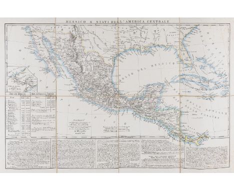
Cental America.- Mexico.- Marzolla (Benedetto) Messico e Stati dell'America Centrale, map of Mexico, covering Guatemala, Nicaragua, and Costa Rica, with inset map of the Panama Canal, lithograph with hand-colouring, sheet 515 x 670 mm. (20 1/4 x 26 3/8 in), dissected and mounted on linen, some scattered spotting, unframed, Naples, 1854.

World.- Genesis flood.- Moxon (Joseph) A Map of all the Earth and how after the flood it was divided among the sons of Noah, map of the World, with Eden located in modern-day Iran, surrounded with decorative border containing 14 vignettes illustrating the Genesis flood narrative, amongst other notable Biblical events, engraving on thin laid paper, platemark 325 x 460 mm. (12 3/4 x 18 1/8 in), sheet 410 x 470 mm. (16 1/8 x 18 1/2 in), central vertical fold as issued, minor surface dirt, small marginal nicks with repairs, unframed, [c. 1710].Literature:Shirley, The Mapping of the World, no. 457

Americas.- Mexico.- Dufour (Auguste-Henri) Mexique Antilles, Etats-Unis, French map depicting the United States, Mexico, Central America, and the Caribbean, with two small inset maps of the Caribbean islands of Guadeloupe and Martinique, engraving with outline hand-colouring, sheet 600 x 830 mm. (23 3/4 x 32 3/4 in), central vertical fold as issued, minor spotting, unframed, [1868].

Asia.- Danet (Guillaume) L'Asie Dressee sur de Nouveaux Memoires Assujetis aux Observations Astronomiq..., map of Asia set within decorative border of coats of arms of Asian nations, and further embellished with a large allegorical title cartouche in the upper right corner, engraving with faint outline hand-colouring on laid paper with watermark of initials 'BR' with crescent, platemark 505 x 710 mm. (19 7/8 x 28 in), sheet 545 x 730 mm. (21 1/2 x 28 3/4 in), central horizontal and further folds, some splitting and toning, surface dirt, spotting and browning, handling creases, unframed, Paris, 1732.

World.- Alexander the Great.- De L'Isle (Guillaume) Alexandri Magni Imperium et Expeditio, large map illustrating Alexander the Great's conquests from his homeland in Macedonia through the Persian Empire and northern Africa, engraving with outline hand-colouring, platemark 470 x 840 mm. (18 1/2 x 33 in), good margins, horizontal folds as issued, some printers' creases and handling creases, minor surface dirt, unframed, Paris, De Zauche, 1731 [or slightly later]; together with a good group of 20 maps of mainly France and Europe, including one by Ortelius of Burgundy, two by Sanson of Brie, and others by Bowen, Chatelain, Johnston, de Vaugondy, and others, engravings, some with outline hand-colouring, various sizes, largest 530 x 600 mm. (20 3/4 x 23 3/4 in), occasional surface dirt and light browning, some spotting and handling creases, unframed, mainly 17th to 19th century (21)

Japan & Korea.- Pinkerton (John) Japan, detailed map of Japan and Korea, from Pinkerton's "Modern Atlas", engraving with original hand-colouring on Edmeades & Pine wove paper with watermark date 1808, sheet 560 x 830 mm. (22 x 32 3/4 in), central vertical fold as issued, with careful repairs to splitting, some minor browning and largely marginal damp-stains, unframed, T. Cadell & W. Davies, 1809.

Australasia & East Indies.- Coronelli (Vincenzo Maria) Nuova Guinea, globe gore showing Northern Australia and the East Indies, with Northern Australia decorated with six vignettes, one with an elephant, Italian text below and verso, engraving on laid paper without watermark, a good impression, map platemark approx. 240 x 290 mm. (9 1/2 x 11 1/2 in), sheet 500 x 355 mm. (19 3/4 x 14 in), minor surface dirt, unframed, [circa 1696].

Australasia.- Discovery of Tasmania and New Zealand.- Valentyn (Francois) Kaart der Reyse van Abel Tasman, map detailing the routes taken by Abel Tasman in Australasia during the two voyages of 1642 and 1644, engraving, on two conjoined sheets of laid paper with watermark of Strasbourg lily, platemark 312 x 480 mm. (12 1/4 x 18 7/8 in), horizontal folds, presumably as issued, some minor spotting and surface dirt, unframed, Dordrecht, J. van Braam, and Amsterdam, G. Onder de Linden, 1726

Australasia.- Capt. James Cook.- Carte de la Nle. Galles Meridle. ou de la Cote Orientale de la Nle. Hollande Decouverte et Visitee par le Lieutenant J. Cook, Commandant de l'Endeavour, Vaisseau de sa Majeste en 1770, map from 'Cartes et Figures des Voyages...', showing the first European discovery of the east coast of Australia, illustrating the routes of the Endeavor, noting locations such as Botany Bay, engraving on laid paper without watermark, sheet 390 x 820 mm. (15 1/4 x 32 1/4 in), central and vertical folds, some handling creases, light off-setting and minor surface dirt, unframed, [1774]; together with 6 further maps of Australia, including maps by the S.D.U.K, Johnson and Ward, and others, engravings and lithographs, some with outline hand-colouring, various sizes, largest 460 x 370 mm. (18 1/8 x 14 1/2 in), occasional surface dirt and browning, handling creases, unframed, 18th and 19th century (7).

Balkans.- Adriatic Sea .- Ruscelli (Girolamo) Tavola Nuova di Schiavonia, map covering the Adriatic coastal region of the Balkans, engraving with early hand-colouring on laid paper with indistinct circular watermark, platemark 200 x 260 mm. (8 x 10 1/4 in), sheet 222 x 290 mm. (8 3/4 x 11 3/8 in), Italian text verso, marginal nicks and tears, some surface dirt, unframed, [circa 1574].

World.- Southern Hemisphere.- Capt. James Cook.- Kaart Van Het Zuider Halfrond, Dutch version of a map recording historic and recent voyages in the Southern hemisphere with particular reference to the Pacific and South Atlantic with the trails of Cook, Tasman and others, engraving by C. van Baarsel, on wove paper with C. & I. Honig watermark, platemark 540 x 540 mm. (21 1/4 x 21 1/4 in), good margins, numerous creases, many as issued, other handling creases and minor surface dirt, unframed, 1795; together with four engraved views of Australia, one of Perth, various sizes, largest 150 x 220 mm. (5 7/8 x 8 3/4 in), unframed, 18th and 19th century (5)

Corsica.- Seutter (Matthäus) Insula Corsica, olim Regni Titulo Insignis..., detailed map of the island of Corsica, engraving with hand-colouring on laid paper, platemark 580 x 495 mm. (22 3/4 x 19 1/2 in), sheet 630 x 540 mm. (24 3/4 x 21 1/4 in), minor handling creases, printers' creases, some spotting and surface dirt, unframed, [circa 1730].
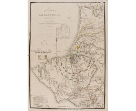
Crimea.- Crimean War.- Wyld (James) The Environs of Sevastopol with the Batteries & Approaches, map and plan of the siege of Sevastopol during the Crimean War, positions of the Allied Armies identified and coloured, lithograph with hand-colouring, sheet 695 x 520 mm. (27 1/4 x 20 1/2 in), central and vertical folds, some careful repairs to old splits, handling creases, minor surface dirt, unframed, 20th October 1854.

Eastern Europe.- Ortelius (Abraham) Romaniae, (quae olim Thracia Dicta) Vicinarumq Regionum, uti Bulgariae, Walachiae, Syrfiae, Etc. Descriptio. Auctore Iacobo Castaldo, map of the classical region of Thrace, covering most of present-day Bulgaria and Romania, engraving on laid paper with indistinct watermark, platemark 360 x 495 mm. (14 1/4 x 19 1/2 in), sheet 420 x 540 mm. (16 1/2 x 21 1/4 in), Spanish text verso, central vertical fold with splitting and small loss to lower section, handling creases, unframed, 1584 [but slightly later]; together with 'Illyricum', a map of the coastal region of Slovenia and Croatia, engraving on laid paper with postal horn watermark, platemark 370 x 480 mm. ( 14 1/2 x 18 7/8 in), some spotting and browning, unframed, [circa 1600] (2)

Europe.- The Rhine.- De L'Isle (Guillaume) The Seat of War on the Rhine being a New Map of the Course of that River from Strasbourg to Bonn with the Adjacent Countries, engraving with some outline hand-colouring, three sheets joined, total approx. 1380 x 630 mm. (54 1/4 x 24 3/4 in), horizontal folds, some minor surface dirt and light damp-stains, unframed, Thomas Bowles, [circa 1710].

Europe.- Sayer (Robert) and Thomas Kitchin. A New and Accurate Map of Europe. Divided into its Empires, Kingdoms, States and Republics &c..., large wall map of Europe, based on the cartography of Robert de Vaugondy, showing from the British Isles and Scandinavia to the Mediterranean, North African coast and the Black Sea, with inset map of Iceland, including tables at sides, and numerous flags of the World along the lower edge, engraving with hand-colouring, on four sheets of laid paper conjoined, total sheet 1020 x 1250 mm. (40 1/4 x 49 1/4 in), numerous handling creases, light surface dirt and minor browning, marginal nicks and tears, unframed, 1772
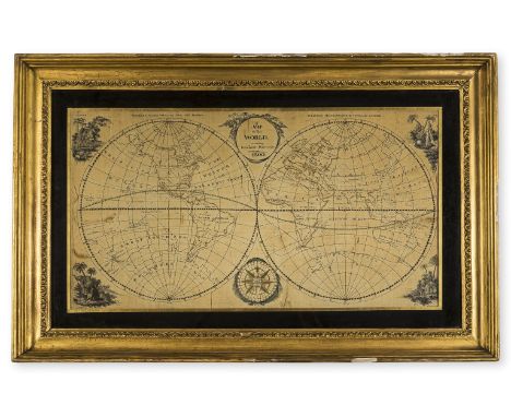
World.- Embroidered Map.- Anonymous (1800) A Map of the World, According to the Latest Discoveries, double-hemisphere world map with vignettes in each corner of Europe, Africa, Asia, and America, with compass rose lower centre, embroidery in several shades of silk thread on a satin ground, with traces of ink, 390 x 720 mm. (15 1/4 x 28 1/4 in), under glass, some splitting in the fabric, light surface dirt, in decorative gilt frame, 1800.⁂ Based on a specially-engraved pattern, with examples of which were known to have been supplied by embroidery shops. Other examples of embroidered maps utilising the same template are known (see Christie's, London, Travel and Natural History, 5th March 2007, and George Glazer Gallery, a Georgian Period Embroidered Sampler by Mary Ann Wood).'Elaborate embroidered maps ... were executed by wealthy girls in formal academic settings using costly materials such as satin and silk. Such projects were designed to combine instruction in both geography and needlework, as sewing skills were essential for the production of clothing and monogramming linens at the time.' [Norman B. Leventhal Map Center Collection]
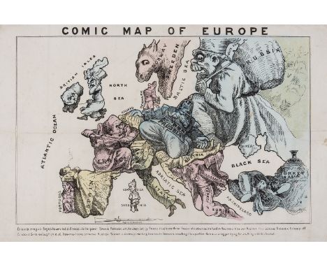
Europe.- Anonymous. Comic Map of Europe, late nineteenth century caricature map of Europe based on Hadol's popular prototype of 1870, caricaturing national leading figures and stereotypes, lithograph with hand-colouring on thin wove paper without watermark, sheet 290 x 445 mm. (11 1/2 x 17 1/2 in), several folds, minor surface dirt and handling creases, unframed, [circa 1880].

France.- Brittany.- Jaillot (Alexis-Hubert) and Joshua Ottens. La Bretagne Divisée en ses Neuf Eveschés, map of the Brittany region of France, engraving with early hand-colouring on laid paper, sheet 525 x 620 mm. (20 3/4 x 22 1/4 in), marginal faint spotting and surface dirt, unframed, Amsterdam, [circa 1705-1710].

France.- Brittany.- Vaugondy (Gilles Robert de) Carte du Gouvernement de Bretagne, engraved map with some outline hand-colouring on laid paper, platemark 525 x 710 mm. (20 3/4 x 28 in), sheet 565 x 785 mm. (22 1/4 x 30 7/8 in), some spotting and surface dirt, faint damp-stain in lower centre, largely marginal, minor marginal nicks and tears, unframed, Paris, 1822.

France.- Normandy.- Ottens (Reiner & Joshua) Le Gouvernement de Normandie..., regional map with fold-out section in the upper right corner, engraving, an excellent impression with early hand-colouring, sheet 590 x 620 mm. (23 1/4 x 24 1/4 in), faint marginal spotting and surface dirt, unframed, Amsterdam, [circa 1720].

World.- Capt. James Cook.- Russell (John) Map of the World Shewing the Tracks & Discoveries of Capt. Cook, double-hemisphere world map, engraving with hand-colouring on wove paper, sheet 410 x 685 mm. (16 x 27 in), several vertical folds as issed, some repairs to splitting, marginal repairs, surface dirt and light browning, Richmond Library stamps verso, unframed, Wilkie & Robinson, and J. Mawman, 1811.

France.- Provence.- Jaillot (Alexis-Hubert) and Joshua Ottens. La Provence Divisée en ses Vigueries, et Terres Adjacentes, regional map of France, from 'Atlas Francois', engraving with early hand-colouring on laid paper, platemark 480 x 610 mm. (18 7/8 x 24 in), sheet 530 x 625 mm. (20 7/8 x 24 1/2 in), faint marginal spotting and surface dirt, unframed, [circa 1705-1710].

France.- French Alps.- Hondius (Jodocus) Sabaudia Ducatus. La Savoié, map of Savoy, engraved map with hand-colouring, on laid paper without watermark, sheet 400 x 515 mm. (15 3/4 x 20 1/4 in), French text verso, central vertical fold with minor repairs to splitting verso, repairs to corners, minor marginal damp-stains, even toning to sheet, some surface dirt, unframed, [circa 1630].


-
109182 item(s)/page