We found 109182 price guide item(s) matching your search
There are 109182 lots that match your search criteria. Subscribe now to get instant access to the full price guide service.
Click here to subscribe- List
- Grid
-
109182 item(s)/page


Lot 664
Squire Osbaldeston: His Autobiography’. London 1926. Autobiography of George Osbaldeston (1786-1866), the renowned huntsman, cricketer and all-round sportsman. Original light brown cloth, folding map etc. Some minor foxing, slight breaking to internal hinges at front and rear otherwise in good condition

Lot 1026
An Early 19th Century English 2 1/2 Inch Terrestrial Pocket Globe, no makers name, inscribed `A Correct Globe with the New Discoveries`, with hand coloured engraved paper gores, together with the original fishskin case containing a hand coloured celestial map to the inside, inscribed `A Correct Globe with New Constelations of Dr Halley & C`,


![David Loggan Collegium Regale [King’s College, Cambridge] double page engraving circa 1690 42 x 55cm (overall); with A](http://lot-images.atgmedia.com/SR/10091/2873198/32-201329102743_468x382.jpg)

![Martin Waldseemuller after Ptolemy Albion Insula Britanica [British Isles] 16th century engraved map in shaped rectangular bo](http://lot-images.atgmedia.com/SR/10091/2873198/34-201329102841_468x382.jpg)


Lot 36
John Seller A Chart of the Sands, Shoals, and Buoys, Beacons, Sea-Marks, upon the Coast of England hand coloured engraved chart showing the coasts of Essex, Kent and Lincolnshire over-printed to title for John Thornton an additional cartouche to the upper left corner titled in pen ‘A New Chart of Ye Kings Chanell.’ 43 x 53.5cm (plate); with a Dutch map of the same area, by Jacob Aertsz Colom 41 x 54cm (2)
![John Speed [Sudbury and Humble] Stafford Countie and Towne uncoloured engraved map after 1610 38 x 50.5cm; with Robert Morden](http://lot-images.atgmedia.com/SR/10091/2873198/40-201329103133_468x382.jpg)
![John Speed [Bassett and Chiswell] Britain as it was devided double page hand coloured engraved map [circa 1676] 39 x 51cm (pl](http://lot-images.atgmedia.com/SR/10091/2873198/43-20132910322_468x382.jpg)


Lot 51
William Heather Chart of the Entrances to the River Thames; Chart of the East Coast of England two uncoloured folding engravings, one dated 1802, both linen backed each 65 x 81cm overall; with Smith’s New Map of England and Wales, 1804 folding linen backed map with hand colouring 58 x 48cm, with original slip case; and one other folding general map (torn) (4)


![John Speed [Sudbury & Humble] The Province Ulster described well coloured engraved map with inset plan of Enis Kelling Fo](http://lot-images.atgmedia.com/SR/10091/2873198/63-201329103258_468x382.jpg)


Lot 68
CARY (John) Traveller’s Companion or a Delineation of the Turnpike Roads of England and Wales, 1810 12mo, map of England and Wales and 42 county maps as required, handcoloured in outline and including folding map of Yorkshire, worn binding detached; AIKIN (John) England Delineated, or a Geographical Description of every county in England and Wales, 4th edition 1800, 8vo, folding uncoloured map and 42 county maps (some age toning), slight ink graffiti at end, chipped and worn calf; with - Geography and History selected by a Lady for the use of her own Children, 8th edition 1811, small 8vo, folding world map frontispiece by Darton and 3 plates as required, 2pp adverts at end, worn and chipped tree calf (3)

Lot 69
Map reference. PIGGOTT (Prof. S) Camden’s Britannia, 1971 facsimile reprint, cloth; YATES (W) Map of the County of Stafford, 1984 reprint, slip case; Kelly’s Directory of Hertfordshire, 1908, folding coloured map, rubbed cloth (faded spine); MASON (O) The Gazetteer of England, 2 vols 1972, slight foxing, in dust jackets; HARVEY (P D A) and H.THORPE. The Printed Maps of Warwickshire 1576-1900, one of 750 copies, 1959, chipped wrapper; TOOLEY (R V) Maps and Map-Makers, 6th edition 1978; Dictionary of Mapmakers, Tring 1979; Tooley’s Catalogue Number One; 6 others


Lot 73
John Chapman and Peter Andre. A Map of the County of Essex from an Actual Survey taken in 1772,1773 and 1774, London 1777, folio, on 26 double page sheets, including title, list of subscribers, and key map, all hand coloured, occasional offsetting, some scattered foxing and staining, rebacked original worn boards


Lot 75
KITCHIN (Thomas) Kitchin’s Post Chaise Companion through England and Wales, London: for John and Carrington Bowles, and Robert Sayer, 1767, small oblong 4to, title, 6pp tables, general map and 103pp road maps, lacking the binding, some brown staining and soiling to title and last leaf, slight vertical centre crease throughout


Lot 229
~ H ~ Norfolk. BRITTON and BRAYLEY. A Topographical and Historical Description of the County of Norfolk, no date, circa 1812, 8vo, folding map, uncut, somewhat age stained, rebacked boards; HUDSON (Rev W) How the City of Norwich Grew into Shape, with 5 maps, 1896, 4to, boards; The Norfolk Tour, 4th edition, 1786, small 8vo, rebacked calf; BROWNE (P) The History of Norwich, circa 1814, 8vo, untrimmed, age toned, modern full calf; with - Jarrold’s County Guide to Norfolk, paper wrapper; and - The Country Gentleman’s Companion, 3rd edition London 1747, small 8vo, extremities stained and foxed, modern full morocco (5)


Lot 236
DEPPING (G-B) L’Angleterre ou Description Historique et Topographique du Royaume Uni de la Grande Bretagne, 2nd edition, 6 volumes, Paris 1828, 12mo, with 59 hand coloured miniature county maps (including Ireland), folding general map and table, and 22 plates, text with some staining/spotting, fine contemporary red half morocco (6)


Lot 292
Various. MOGG (Edward) Paterson’s Roads, 18th edition circa 1829, 8vo, folding general map, 9 other folding maps on fine paper (slight staining), appendix bound at end, rubbed half calf; Mountains and Mountain-Climbing, London 1883, 8vo, illustrated, polished calf gilt; GUILLEMIN (A) The Heavens, 9th edition 1883, 8vo, plates, prize green calf gilt; 6 others leather bound; KIPLING (R) The Irish Guards in the Great War, 2 vols 1997; etc (a box)

Lot 315
Literature, various, including leather bound: Rubaiyat of Omar Khayyam, 1897, half morocco gilt by Sotheran; G.V. Dinners and Dinner-Parties, 2nd edition, 1862, 8vo, cloth gilt; an interesting domestic diary and journal for 1871; Baedeker Guide to London, 1911 (map loose); 3 other Baedeker guides; few others (a box)

Lot 316
Literature, various, including: ROBESON (Paul) Here I Stand, 1958, inscribed by the author to William Griffiths [bookseller in London], without dustjacket; SCOTT (Walter) Lady of the Lake, 1853, with tartan binding painted to the centre with a small oval landscape entitled ‘Ben-A’an’; CLARK (Richard) An Account of the National Anthem entitled God Save the King!, 1822, 8vo, subscribers list, engraved plates and music, later cloth retaining original spine label; Canadian Tour of General his Imperial Highness Prince Fushimi G.C.B., June 1907, worn covers with damaged spine, with separate bound map; etc (a small box)
![TOLKIEN (J R R) The Hobbit, 1942 reprint [third impression], illustrated by the author, 2pp adverts at end stamped ‘5 -](http://lot-images.atgmedia.com/SR/10091/2873198/361-201329102943_468x382.jpg)
Lot 361
TOLKIEN (J R R) The Hobbit, 1942 reprint [third impression], illustrated by the author, 2pp adverts at end stamped ‘5 - 43’ at foot, map endpapers, neat ownership name to a fly leaf otherwise internally clean, publisher’s green cloth, slight wear to spine ends and corners, with trimmed front and back parts of dust jacket only remaining


Lot 371
BRITTON (J) The History and Antiquities of the Abbey and Cathedral Church of Gloucester, 1829, 4to, plates, some typical staining, recased; SHOBERL (F) Suffolk or Original Delineations, London 1818, folding map, plates, some staining and foxing, uncut, modern half calf; POINTER (J) Oxoniensis Academia, 1749, small 8vo, age stained, rebacked calf; one other (4)
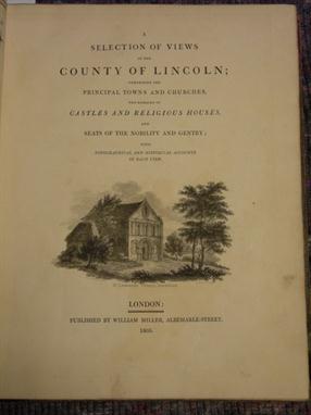
Lot 377
HOWLETT (B) A Selection of Views in the County of Lincoln, 1805, 4to, coloured map frontispiece, engraved plates (some damp staining and spotting), binding worn; DAVY (Henry) Views of the Seats of the Noblemen and Gentlemen in Suffolk, part first, Southwold 1827, small 4to, some foxing and staining, half morocco rubbed; ELMES (James) Metropolitan Improvements or London in the Nineteenth Century, 1829, 4to, numerous engravings, typical spotting and staining, half calf rubbed (3)


-
109182 item(s)/page