We found 109198 price guide item(s) matching your search
There are 109198 lots that match your search criteria. Subscribe now to get instant access to the full price guide service.
Click here to subscribe- List
- Grid
-
109198 item(s)/page


Lot 1
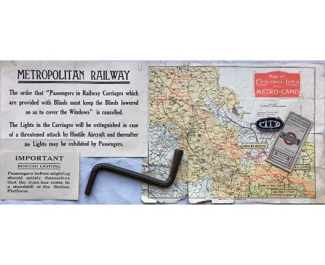
Small collection of transport items comprising 2 x WW1 Metropolitan Railway CARRIAGE NOTICES re blinds and lighting (very good condition), a cast-iron London Tram HANDLE inscribed 'LCCT' (ex-use condition), a cloth UNIFORM BADGE 'City' (some wear), a 1925 London General bus routes POCKET MAP (used) and a c1920 Metropolitan Railway double-sided map (very tatty). [6]

Lot 22
1919 Railway Clearing House 'Official Railway MAP of London & its Environs'. These highly detailed, coloured maps were produced to help the office staff of the RCH to apportion the revenues to the railway companies from the operation of services over each other's tracks. Linen-backed inside hard covers, the map opens out to 51" x 40" (130cm x 102cm). In good, used condition. Plus a well-used c1931 'Stingemore' London Underground linen-card POCKET MAP. [2]

Lot 116
Selection of early London Underground POSTCARDS comprising 1908 map by Waterlow & Sons with promotion of the Franco-British Exhibition on the reverse (French language version, postally used 1909), 1906 Great Northern, Piccadilly & Brompton issue 'Interior Car shed', 1907 'Hampstead Tube' (map on reverse) issued by LUER and 1907 Bakerloo & Piccadilly Tubes (interior of car) issued by W H Smith. The last 3 postally unused. [4]


Lot 214
1973 London Underground quad-royal POSTER MAP designed by Paul Garbutt. Shows both the Piccadilly extension to Heathrow and first stage of the "Fleet" Line from Baker Street to Strand as 'under construction'. Strand Station is shown crossed out with a notice at the foot of the map that it is closed from June 1973 - 1976. In excellent condition with minor blemishes only. [1]

Lot 382
1919 edition of "Metro-Land' BOOKLET, published by the Metropolitan Railway. 80pp with some colour illustrations. Includes the original fold-out map of 'Extension Lines into Metro-Land' on one side and the central section of the Metropolitan Railway, rest of the Underground and other railways on the reverse. Some wear and small stains to the covers, the contents and map are good to very good. [1]


Lot 44
1907 MAP of North Eastern Railway and Connections. Linen-backed inside hard covers, opens out to 35" x 44" (89cm x 112cm), colour-coded to show NER and other companies as well as natural resources (aggregates etc). Plus 1920s LEP Transport & Depository Ltd PLAN of the County of London. Stamped 'LM&S Rly Supt's Office 18 Jan 1926'. Linen backed inside soft covers, opens out to 36" x 26.5" (92cm x 67cm), shows the company's offices and depôts. Both maps in very good condition, some wear to covers. [2]


Lot 2305
A First World War period memorial plaque detailed Leonard Haworth, with the forwarding slip and memorial scroll, detailed L.SERJT. LEONARD. HAWORTH. LOYAL N.LANCASHIRE REGTand a postage tube, a 1914-19 Victory Medal to 22705 PTE.T.HITCHINGS. K.R.RIF.C.(wth attempted erasure of the naming), a ribbon bar, a quantity of artillery style costume buttons, a Services Sports watch, the dial detailed Services Army, a book marker, a silk map of part of France, a commemorative scarf and a khaki side cap, (10).


Lot 564
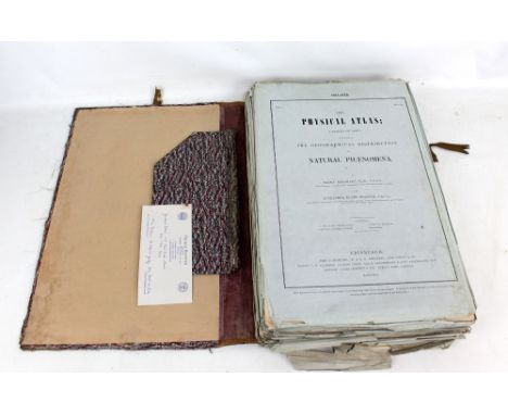
H. BERGHAUS & A. KEITH JOHNSTONE; 'The Physical Atlas; A Series of Maps Illustrating the Geographical Distribution of Natural Phenomena', parts I-X, pub. J. Johnstone, W & A. K. Johnstone and Cowan & Co, Edinburgh 1845.Additional InformationTears, fraying, discolouration, general wear and tear to the outer sleeves, map page edges frayed and discoloured, the outer boards in which the maps are housed is very worn, taped, should be considered af.


Lot 311
Belgium & Holland. Speed (John), A new Mape of ye XVII Provinces of Low Germanie, Mended a New in Manie Places, pub. Thomas Bassett & Richard Chiswell, c.1676, uncoloured ‘carte a figures’ map, ten costumed vignettes to vertical margins and eight oval engraved views of cities to upper margin, 42 x 53.5cm, English text on verso, framed and double glazed CONDITION REPORT: foxing and discolouration, the bottom is trimmed,
Lot 1
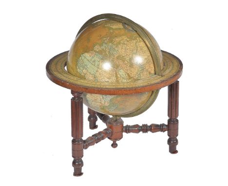
A late Victorian 12 inch library table globe, Malby’s published by George Philip and Son, London 1898.The sphere applied with twelve coloured printed gores incorporating trade label MALBY’S, TERRESTRIAL GLOBE, Completed from the latest, & MOST AUTHENTIC SOURCES, including all the recent, Geographical Discoveries, AGENTS, GEORGE PHILIP & SON, MAP & ATLAS PUBLISHERS, 32 Fleet Street, LONDON and dated 1898 to North Pacific and extensively annotated with principal cities, towns, rivers, lakes, mountains and other significant topographical features, the oceans with all significant islands labelled, the West Pacific with AN ANALEMMA of the equation of time, and the Equator and Eliptic lines graduated in minutes, each pole with brass hour ring and pivots for mounting within the brass meridian circle divided for degrees, resting in wooden stand with hand coloured paper horizon ring graduated in degrees in two directions, days-of-the-month and houses of the Zodiac with names and symbols and also displaying compass directions, with explanatory note between March and April including the text Engraved by Cha’s Malby, raised on three reeded turned supports with triform baluster stretcher to support the meridian ring at the base, 46cm, (18ins) high approx. Thomas Malby and Company are recorded in Gloria, Clifton Directory of British Scientific Instrument Makers 1550-1851 as working 1843-50. First as Thomas Malby alone at 22 Houghton Street, Clare Market, London in 1839, then from 3 Houghton Street, Newcastle Street, Strand 1845-48 and finally at 37 Parker Street where the firm became Thomas Malby and Son in 1851. Thomas Malby is perhaps most remembered for producing an impressive 36 inch diameter terrestrial globe based on Addison's 1825 model. Latterly the firm of Thomas Malby and Son aligned themselves as geographical publisher for The Society for the Diffusion of Useful Knowledge (S.D.U.K) and innovated the inclusion of 'magnetic lines of variation' within their terrestrial globes. By 1898 Thomas Malby and Son were trading as ‘Globe and Map Sellers to the Admirality’ from 37 Tithe Queens Street Holborn, London. The Engraver’s signature to the horizon paper relates to Thomas’s brother, Charles Isaac Malby (1816, post 1868), who worked as one of the principal engravers within the firm.

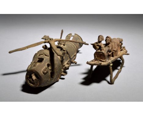
Lot 1076
An Akan helicopter with figures Ghana brass, with applied lettering UNITY STAR JET, the body lifting to reveal a seated pilot and co-pilot, reading a map, a further seat and an engine, 11cm high, 22cm long. Provenance Made for Timothy Garrard (1943 -2007) State attorney in Ghana, scholar and leading expert on Akan goldweights.


-
109198 item(s)/page