We found 109198 price guide item(s) matching your search
There are 109198 lots that match your search criteria. Subscribe now to get instant access to the full price guide service.
Click here to subscribe- List
- Grid
-
109198 item(s)/page


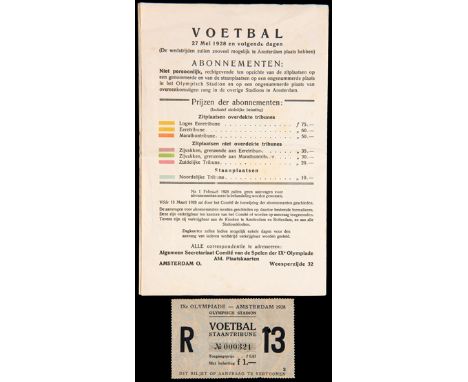
Lot 1245
A ticket for the Italy v Uruguay semi-final match in the football competition at the Amsterdam 1928 Olympic Games, a standing ticket, numbered 13, for the match at the Olympic Stadium 7th June; plus a very rare ticket price brochure for the Games with a key to the ticket colour relating to the type of ticket and map of the Olympic Stadium (2)

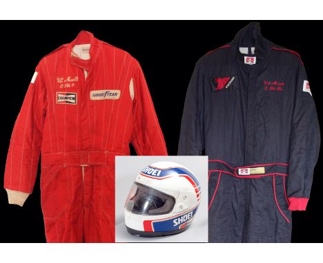
Lot 490
Val Musetti 1989 race-worn Shoei helmet with two racesuits and accessories, a white Shoei helmet with replica Wayne Gardner design in blue, gold and red, FISA/ ACU approved, with visor and helmet bag; two Nomex racesuits by 'Formula One', each bearing his embroidered name and blood group, one in plain red with Champion and Goodyear logo patches, the other in black with red trimming, a Yokohama logo patch on the right breast, the belt with FIA approval patch, a pair of 'Monza' driving boots from Adidas, two pairs of gauntlet gloves from Kiwi and Nomex, also a Nomex balaclava and vest; sold with a digital image of the red suit in use and a 1987 Spa circuit map with personal notation (qty.). In the 1980s Val Musetti raced sportscars internationally, including a Porsche 962 in the FIA World Sportscars Championship, and competed at Le Mans. He was Christopher Reeve's stunt double in Superman I & II and appeared in many other Hollywood films, including Batman and James Bond.
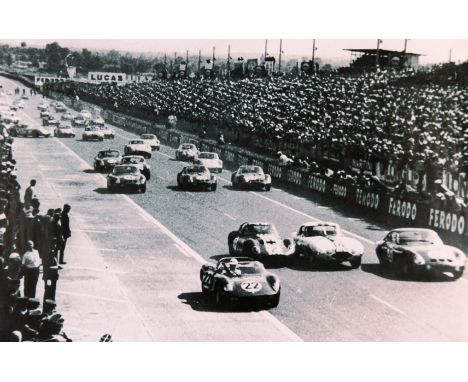
Lot 471
1963 Le Mans 24-Hour race and 1995 Jean Alesi-Michael Schumacher photographic posters, the first a large black & white photographic print of the start, 44 by 68cm., 17 by 27in., the second a similar sized colour photographic print of Jean Alesi accepting a lift from Michael Schumacher after winning the 1995 Canadian GP, plus a folded 1986 British GP double-sided promotional poster.; 50 by 72cm., 20 by 28in.; sold with a 1948 Luton Hoo Easter Monday Speed Trials programme complete with course map and supplementary regulations inserts, some results notation (4)

Lot 177
A World War II commemorative copper plated souvenir cigar/cigarette box, the hinged lid depicting a map of the Middle Eastern and Mediterranean battlefields, the sides listing key dates and battlefields, the base stamped "Brass used in the manufacture of this box was salvaged from the battle fields of World War II" "Granger, Made in Egypt" height 5cm, width 16cm, depth 16cm,


Lot 700
JAMES BOND 1:8 SCALE ASTON MARTIN; One of the best diecast models of a James Bond car in existence. A large heavy quality 1:8 scale Eaglemoss diecast precision model of James Bond's Aston Martin DB5. Highly detailed, the original spec for the model includes; working rear and front lights, working horn, ejector seat, accelerator sound effects, brake lights, light up map to interior, machine guns in lights, movable bullet proof rear screen, key ignition, rubber tyres etc. This particular model is well made. Just one or two of the features are not working (horn, one headlight), but on the whole this set is in fantastic condition. Comes with a custom made glass display case and plinth, and original magazines (not photographed) 56cm long, approx 8.5kg.


Lot 1251
'The Story of the 55th (West Lancashire Division)' by The Rev. J.O.Coop, printed by Liverpool 'Daily post', 1919 together with 'History of the 359 (4th West Lancs) Medium Regiment R.A 1859 - 1959 and 'W.M Briggs & Co. Badges of H.M Services' together with an autographed copy of 'An Act of Treachery' by Ann Widdecombe, Weidenfeld & Nicolson and 'Philips Tape Indicator Map of London' by George Philip & Son Ltd and a rare and useful reference book 'The Common Moths of England'.


Lot 279
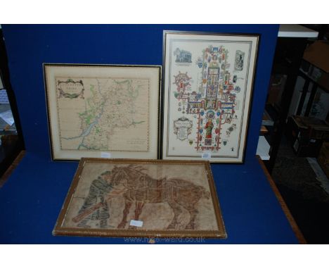
An 18th Century French map of China by Le SR D’Anville Geographe Ord Du Roi, 1732. 50 x 79cm. Another entitled ‘Carte Nouvelle De La Grande Tartarie Ou De L’ Empire Du Grand Cham. 40 x 50cm a Dutch map entitled Magne Tartarie Magni Mogolis Imperll Iaponie et China. By Frederick de Wit Veer. 44 x 53cm (3).


Lot 436
A Thomas Jefferys map, The East Indies, with hand colouring, and two others of Devon (3) Condition report Report by RB Maps of Devon: T Kitchin - Devonshire Drawn from the best Surveys, Maps, Charts and Regulated by Astrony Observatories, tinted, some browning. A Map of Devon Shire, West from London, published 1742, tinted, some fading and browning.
Lot 355
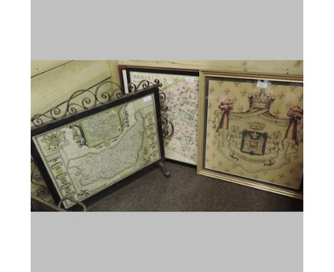
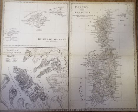
A collection of eleven Cities Of Italy maps, drawn by W V Clarke, various engravers, including Corsica and Sardinia, with Malta and the Balearic Islands, Florence, and Genoa, in a slip case Condition report Report by GH Many of the maps in the lot are indeed published by SDUK, however several are published by Baldwin & Cradock, including Florence, Naples and Pompeii. The maps published by SDUK include Modern Rome, Ancient City of Rome, Ancient Syracuse, Turin and Venice. There are various condition faults, including light foxing, discolouration to edges and cropping. All of the maps are linen backed and in four sections, with the exception of one larger map which is in eight sections. The linen backing was clearly applied a long time ago. The maps have been cropped. taking away part of the margin, and in some cases the publisher information has been partially cut off. The maps generally present reasonably well.

Lot 517
A group of four WWII German maps for Operation Sealion planned invasion of Great Britain and Ireland, including map of power plants and major power lines in England and Scotland, map of the railway lines of Great Britain and Ireland, map of the waters and rivers of Great Britain, and a map of Ireland showing roads, canals, railways etc, all housed in wallet marked Military Geographical Indications about Ireland, 1940. Maps dated 1940 and 1941.


Lot 95
Fishing - A Fox Match case together with a coarse fishing suite consisting of a Carbonative 14' float rod, a Map 17' float trotting rod, a Matchtec 13' feeder rod with three tips, an Okuma Epix Pro EPB30 coarse reel in pouch with two spare bobbins and a Shakespeare Polycast OPF 30M coarse reel by Okuma in pouch with two spare bobbins (6)


-
109198 item(s)/page