We found 108737 price guide item(s) matching your search
There are 108737 lots that match your search criteria. Subscribe now to get instant access to the full price guide service.
Click here to subscribe- List
- Grid
-
108737 item(s)/page


Lot 1811
A GOLD AND EMERALD BROOCH AND THREE PENDANTS (4)The emerald brooch designed as a map of South America, with Columbia mounted with a rectangular cut emerald, a circular gold pendant with a winged animal motif, detailed 750, weight 3.8 gms, a gold pendant with floral decoration, probably Asian, detailed 750, weight 4 gms and a gold and varicoloured and colourless gem set pendant, designed as a basket of flowers having a mother-of-pearl backing, indistinct gold mark, gross weight 4.1 gms
Lot 3067
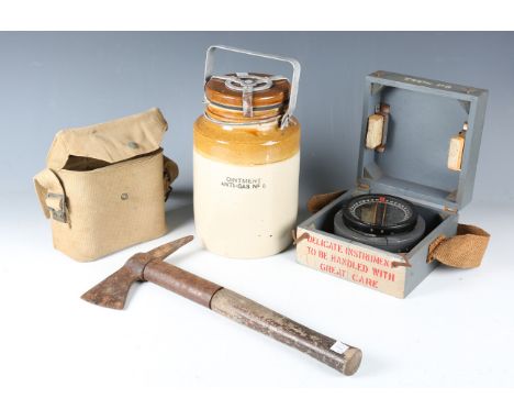
A small group of military-related items, comprising a salt glazed 'Ointment Anti-Gas No. 5' jar, a Defiant air raid warden's axe, dated '1940', an Air Ministry compass, cased, and a canvas map or binocular case.Buyer’s Premium 29.4% (including VAT @ 20%) of the hammer price. Lots purchased online via the-saleroom.com will attract an additional premium of 6% (including VAT @ 20%) of the hammer price.

Lot 39
A GROUP OF THREE MAPS OF EUROPE INTEREST PUBLISHED BY HOMANN HEIRS, NUREMBURGComprising; a General Map of Great Britain and Europe... By the Heirs of late Mr. Homann, at Nuremberg 1749 Priviledged by Emperours Majesty, 49 x 57cm, Scandinavia, 48 x 56cm, and Normannia (Normandy), 48 x 58cmAll mounted and in later stained wood frames, 82 x 72cm overall and smallerTogether with After J Payne, Sovereign (Soveraigne) of The Seas, built 1637, coloured engraving, 79 x 103cmCondition Report: The map of Normandy has broken glass and this will need to be replacedCondition Report Disclaimer

Lot 511
A SET OF SEVEN MAPS OF PARIS FROM NICOLAS DE FER'S ATLAS CURIEUXPublished by Nicolas de Fer 1646-1720, 1717. Plans de la ville de ParisAll mounted and gilt framed, 34 x 44cm overall, the visible map 22 x 33Condition Report: As updated to the cataloguing these are all framed, all in presentable order overall, with impression marksUnexamined out of the framesPlease see additional images of each map for referenceCondition Report Disclaimer

Lot 209
Two bottles of Château Cantemerle 1996, Haut Medoc Bordeaux, France.Category: Red wine.75 cl.Level: A-B.Château Cantemerle is a winery in the Haut-Médoc appellation of the Bordeaux wine region of France, in the commune of Macau. The wine produced here was the final property to be classified as one of the eighteen Cinquièmes Crus (Fifth Growths) in the Official Bordeaux Wine Classification of 1855. Its absence from the classification map presented at the 1855 Paris Exposition Universelle generated some controversy, although it has been included on all maps published after 1855. Some sources will include an asterisk next to the listing of Château Cantemerle in reference to this controversy. The estate has a long history in the Haut-Médoc with records detailing its existence since at least the 12th century and wine production since at least the 14th century. In the 19th century, the estate was severely affected by the phylloxera epidemic and mildew vine attacks, after which production was reduced by almost 50%. Towards the end of the 20th century, the estate was sold to the French insurance group Les Mutuelles d'Assurance du Bâtiment et des Travaux Public, which has contributed significant investment in the estate's vineyards and winemaking facilities.

Lot 362
Pigot & Co. Maps of the Counties of Derby, Hereford, Lincoln...Warwick and Worcester with a General Map of Wales, nine whole page engraved maps on wove in contemporary colour, folio, original wrapper with engraved title, c.1820 The collection of C. W. Briggs (1906-1971) (lots 1-429) somewhat soiled and grubby many of the maps clean, the larger map of Wales good but for one or two spots of foxing
Lot 263
including a Tunbridgeware box with a map of Somerset, a sovereign balance in wood box, a spectacles case with a view of the Bourse, Paris, two composition snuff boxes, with views of the Place Vendome and Le Madeleine Paris and seven other items (12). ** Please contact Connor for further information connor.swanwick@lawrences.co.uk.


![[TRAVEL]. ELEVEN BAEDEKER'S GUIDE BOOKS comprising Belgium and Holland, fourteenth (revised) edition, 1905; Northern Italy,](https://cdn.globalauctionplatform.com/5f59ade4-556b-4113-a5a3-af3c00bde274/c0518c76-fa00-4633-9dd2-af7300da0007/468x382.jpg)
Lot 106
[TRAVEL]. ELEVEN BAEDEKER'S GUIDE BOOKS comprising Belgium and Holland, fourteenth (revised) edition, 1905; Northern Italy, fourteenth (rev.) edition, 1913; Austria, ninth (rev.) edition, 1900; Southern Italy, seventh (rev.) edition, 1880; Eastern Alps, seventh (rev.) edition, 1891; Paris and its Environs, sixteenth (rev.) edition, 1907; Southern France, fifth edition, 1907; Switzerland, nineteenth edition, 1901; Rhine, twelfth (rev.) edition, 1892; Great Britain, seventh (rev.) edition, 1910; and Central Italy, fourteenth (rev.) edition, 1904, all original red cloth, maps, octavo. Condition Report : Great Britain lacking map frontispiece; Eastern Alps with weak upper hinge; Austria with detached map frontispiece and weak lower hinge; N. Italy with short tear at base of upper joint. Condition reports are offered as a guide only and we highly recommend inspecting (where possible) any lot to satisfy yourself as to its condition.


Lot 324
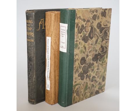
Fussell, L.A. - Journey Round the Coast of Kent, 8vo, rebound, facsimile folding map, Baldwin, Craddock and Joy, London 1818 and Shindler; Rev. R - Mission Work among The Hop-Pickers in the Weald of Kent, London [circa 1895]; Oulton, W.C - Picture of Margate, and its Vicinity, 8vo, rebacked, lacking early text and some plates, other plates trimmed, remounted and bound in, London 1820 (3)


Lot 252
A hand coloured engraved map with of Part of Suffolk and Kent. By Morden and Speede, probably late 17th century, 'Described by John Morden, Augmented by J. Speede and to be Solde by Thomas Bassett in Fleet Street and Ric Chiswell in St Pauls Church Yard' dated 1662, with the coats of arms of the Earles of Essex, the reverse with The Description of Essex, 53cm x42cm exc. frame


Lot 273
A hand coloured engraved map of Somersetshire by Robert Morden, circa 1695 or later. In ebonised and parcel gilt frame, 42cm x 36.5cm exc. frame Condition Report: Cut through mid section and joined, some minor discolouration and crinkled surface, some chipping and flaking to edge of frame, unexamined outside of frame.


Lot 354
Various gilt framed and glazed hand-coloured engravings including: a map engraving of Warwickshire, an early map engraving 'The South-West view of Egremont Castle, Cumberland' views of Birmingham, views of Trinity Chapel, Bordesley, Free Grammar School, Birmingham a monochrome engraving of University of Birmingham by Wilfred C. Applebey and other similar (7)


Lot 133
Limited edition The Library Shakespeare, no 2298/4000, illustrated by Sir John Gilbert, George Cruikshank and R. Dudley, pub. Midpoint Press, Really Useful Map Company Limited 2007, green cloth hardback with gilt titles and decoration and silvered edges, together with other Shakespeare related books comprising Keate's Shakespeare pub. Oxford University Press 1929, set of three Olive Classics and The Histories, pub. Collins 1966 (6)


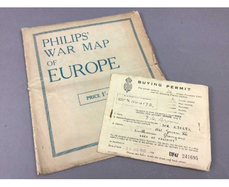
Lot 702
LOT OF MILITARY ITEMS,to include a Buying Permit with vouchers, June 1945, to JC Brown, a Philips War Map of Europe, 1945, showing all the army locations, a Royal Navy metal tobacco box, a collection of military coins, a quantity of 'Recordacao De Lisboa post cards and a framed portrait of a military personnel member
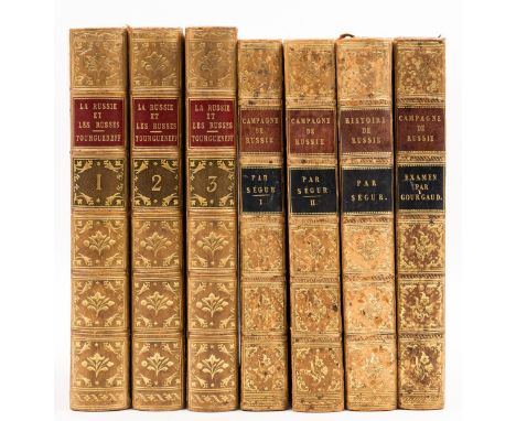
Lot 149
Russia.- Tourgueneff (Nikolai Ivanovitch) La Russie et les Russes, 3 vol., first edition in French, half titles, some light foxing, contemporary mottled calf, gilt, with armorial device to upper covers, spines with red and green morocco labels, Paris, Au Comptoir des Imprimeurs-Unis, 1847 § Ségur (Comte de) Histoire de Napoleon et de la grande armée pendant l'année 1812, 2 vol., third edition, half-titles, 6 lithograph plates, folding map (a few small tears at edges), off-setting, contemporary mottled calf, spines gilt with red and black morocco labels, Paris, Baudouin Frères, 1825; Histoire de Russie, light foxing, contemporary mottled calf, spines gilt with red and black morocco labels, Paris, Baudouin Frères, 1829; and another, 8vo (7)

Lot 31
Britain.- Jansson (Jan) Britannia prout divisa suit temporibus Anglo-Saxonum, praesertim durante illorum Heptarchia, map of the British Isles, margins decorated with 14 scenes of Saxon figures and events to side panels, engraving with full early hand-colouring, on laid paper without watermark, sheet 420 x 528 mm (16 1/2 x 20 3/4 in), trimmed to borderline and mounted on paper old paper support, a few repaired small perforations within the map, scattered spotting and minor surface dirt, unframed, [Amsterdam, 1646]
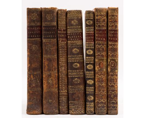
Lot 30
Britain.- Gilpin (William) Observations, Relative Chiefly to Picturesque Beauty ... on Several Parts of Great Britain; Particularly the High-Lands of Scotland, 2 vol., first edition, 40 aquatint plates and maps, offsetting, occasional foxing, lacking half-titles, contemporary tree calf, spines gilt with red and green morocco labels, [Abbey Scenery 487], 1789; Remarks on Forest Scenery and other Woodland Views, Illustrated by the Scenes of New-Forest, 2 vol. first edition, folding map, partially hand-coloured, 31 plates, most tinted aquatints, lacking half-titles, some light offsetting, armorial bookplate of Sir John Eden to front pastedowns, contemporary speckled calf, rubbed, some loss to spine labels, [cf. Abbey Scenery 149], 1791; and 3 others, Gilpin, 8vo (7)

Lot 58
NO RESERVE South Africa.- Faden (William) The Dutch Colony of the Cape of Good Hope, second edition, showing from Klipping Island and St. Helen's Bay in the north to to False Bay in the south, engraved map by Louis de la Rochette, on thick wove paper, platemark 520 x 355 mm (20 1/2 x 14 in), wide margins, some exposure lines, stamped number '48' in the upper right margin, scattered spotting, unframed, 1795; together with Bellin's 'Le Pays des Hottentots aux Environs du Cap de Bonne Espérance', unframed, 18th century (2)

Lot 32
Britain.- Jansson (Jan) Essexiae Descriptio. The Description of Essex, county map, engraving with hand-colouring, sheet 440 x 530 mm (17 1/4 x 20 3/4 in), central vertical fold with some splitting, old folds, minor surface dirt, unframed, [circa 1646]; together with Robert Morden's 'Norfolk', Thomas Malton's etching and aquatint London view 'The Bank', a wood-engraving with hand-colouring of the interior of the Stock Exchange from The Graphic, an original political cartoon by 'Mac' satirising Princess Diana's marriage, and a miscellaneous quantity of small engravings and cuttings, including Vanity Fair prints, fashion plates, some ephemeral engravings and others, all unframed, 18th and 18th century (Sm. qty.)
Lot 23
Yorkshire.- Thoresby (Ralph) Ducatus Leodiensis: or, the Topography of the Ancient and Populous Town and Parish of Leedes ..., first edition, engraved portrait frontispiece, 11 engraved plates, 8 folding, 1 folding map, illustrations, list of subscribers, early ownership inscription of J. Godfrey of Norton Court with his marginal annotations throughout, 7D2 with short tear to top edge not affecting text, occasional spotting, contemporary panelled calf, red morocco spine label, richly gilt spine, folio, for Maurice Atkins, and sold by Edward Nutt, 1715.
![Oxfordshire.- [Plot (Robert)] The Natural History of Oxford-shire, being an Essay toward the Natural History of England, firs](https://cdn.globalauctionplatform.com/236ad2e0-d9e7-4fcd-87c5-af6600f51829/13f5192b-3785-4814-813a-af660105bcb2/468x382.jpg)
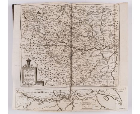
Lot 21
Oxfordshire.- [Plot (Robert)] The Natural History of Oxford-shire, being an Essay toward the Natural History of England, first edition, imprimatur ff., engraved title vignette, 16 engraved plates, 2 with short marginal tears and old repairs, engraved folding map at end, large tear repaired and laid down, engraved head-piece and initial to dedication, imprimatur and title strengthened at gutter, one or two marginal pencil notes, plate list in manuscript to errata verso, 2M2 with short marginal tear, modern panelled calf, red morocco spine label, richly gilt spine, [Wing P2585], folio, Oxford, at the Theater ..., 1677.
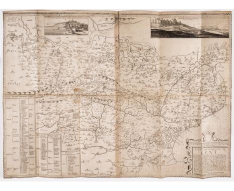
Lot 36
Kent.- Philipott (Thomas) Villare Cantianum: or Kent Surveyed and Illustrated, first edition, large engraved folding map detached and linen backed with a few repaired tears, engraved illustrations, occasional light damp-staining or browning, the odd short marginal tear, contemporary calf, rebacked, rubbed, some wear to extremities, new endpapers, [Wing P1989], small folio, by William Godbid, 1659.
-
108737 item(s)/page