We found 108737 price guide item(s) matching your search
There are 108737 lots that match your search criteria. Subscribe now to get instant access to the full price guide service.
Click here to subscribe- List
- Grid
-
108737 item(s)/page


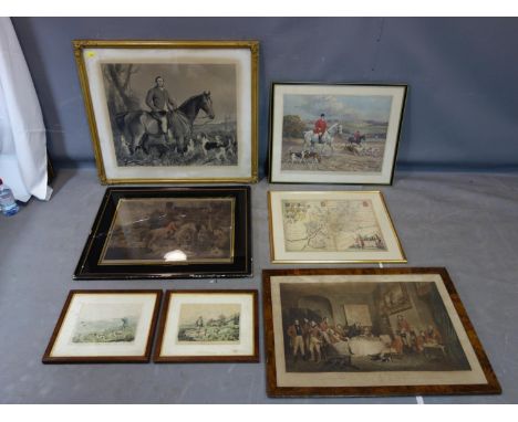
Lot 421
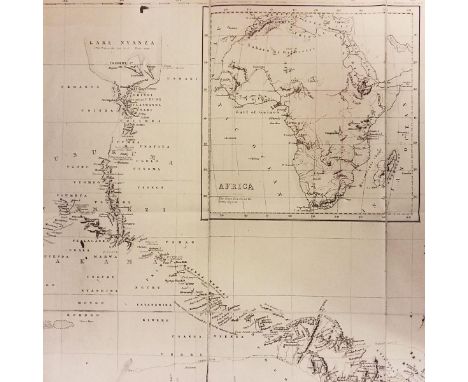
After Emmanuel Bowen 'A NEW AND ACCURATE MAP OF THE ISLAND OF JAMAICA...' Published 1752, image 34 x 42cm T Jeffrerys 'PLAN OF THE HARBOUR OF CARTHEGENA' plate 22 x 33cm J Rapkin 'JAMAICA' with coloured highlights 26 x 34cm J Faber, after S Hudson 'THE HONOURABLE CHARLES KNOWLES, ESQ... GOVERNOR OF HIS MAJESTY'S ISLAND OF JAMAICA' Mezzotint 36 x 26cm (4)


Lot 165
A British Military Escape Map 1944.South-East Asia Sheets 44 F And E. Two Back-To-Back Escape Maps On One Folding Silk Map. Size Approx 95 By 60 cm. Scale 1;100,000. Folds To Pocket Handkerchief Size Or Smaller. Side 44F Is Titled Siam (Thailand) (Extreme South), Malaya (FMS), Sumatra (Central). Side 44E Is Titled Siam (Thailand) (Part Of), Sumatra (North). Maps Are In Colour With A Colour-Coded Key To Heights And A Conventional Key To Features Such As Mountains, Islands, Railways, Stations, Ruins, Post Offices, Roads etc. Heights Also Shown By Contours. Overprinted In Red With Geographical Features Such As Flat Swampy Jungle, Rubber, Undulating Jungle Etc. Includes Singapore And Penang.


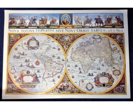
Lot 538
World Map Print 27x38 approx Nova Totvis Terrarom Sive Novi Orbis Tabvla by G.Blaeu. Good Condition. All autographs are genuine hand signed and come with a Certificate of Authenticity. We combine postage on multiple winning lots and can ship worldwide. UK postage from £4.99, EU from £6.99, Rest of World from £8.99.


Lot 1
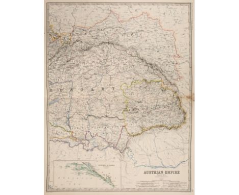
Atlases. Johnston (W. & A. K. Ltd. publishers), Johnston's Royal Atlas of Modern Geography, 1910, title page with old library stamp, numerous colour printed maps, including many double page, partially disbound with contents shaken and loose, slight spotting throughout, all edges gilt, boards and spine covered in later velvet, heavily worn and frayed, folio, together with an earlier edition of 1861, with Bartholomew (John). The Imperial Map of |England & Wales According to the Ordnance Survey..., published A. Fullarton & Co., circa 1870, sixteen (only) colour printed double page maps, some staining and spotting, text block detached, contemporary half calf gilt, heavily worn and frayed, spine crudely repaired, folio (Qty: 3)NOTESSold as a collection of maps, not subject to return.
Lot 27
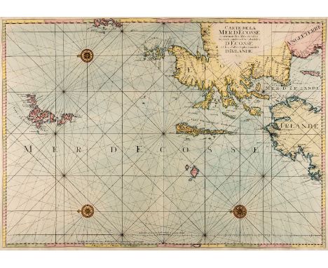
Scotland. Jaillot (Alexis Hubert), Carte de la mer D'Ecosse contenant les Isles et Costes septentrionales et occidentales D'Ecosse et les costes septentrionales D'Irlande, [1693 - 1753], large hand coloured engraved sea chart orientated to the west, old manuscript numbers in upper margin, one repaired closed tear affecting image in upper left corner, 600 x 850 mm (Qty: 1)NOTESThe map was originally published in the "Neptune Francois" in Paris in 1693 by Alexis Hubert Jaillot and soon pirated by Pierre Mortier in Amsterdam and published the same year. This example is from a later publication of the "Neptune Francois" by J.N.Bellin.
Lot 3
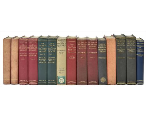
Gordon (Charles). The Journals of Major-Gen. C. G. Gordon at Kartoum, printed from the Original MSS. Introduction and Notes by A. Egmont Hake, 2 volumes, 1st edition, Kegan Paul, Trench, & Co., 1885, etched portrait frontispiece, folding map, map in text, together with: Dickson (Wiliam Kirk), The Life of Major-General Sir Robert Murdoch Smith, 1st edition, Edinburgh: William Blackwood and Sons, 1901, photogravure portrait frontispiece, Glover (Elizabeth Rosetta), Life of Sir John Hawley Glover, 1st edition, Smith, Elder, & Co., 1897, 2 photogravure plates, 3 folding maps, Moore (John), The Diary of Sir John Moore, edited by J. F. Maurice, 2 volumes, 1st edition, Edward Arnold, 1904, photogravure frontispiece, 7 folding maps, errata slips, Atkins (John Black), The Life of Sir William Howard Russell, the First Special Correspondent, 2 volumes, 1st edition, John Murray, 1911, photogravure frontispieces, lending library labels removed from rear pastedowns, Funston (Frederick), Memories of Two Wars, Cuban and Philippine Experiences, 2 volumes, 1st UK edition, Constable & Co., Limited, 1912, photogravure frontispiece, 32 plates, Ogston (Alexander), Reminiscences of Three Campaigns, 1st edition, Hodder and Stoughton [circa 1920], frontispiece, folding plate , Melville (Charles Henderson), Life of General the Right Ho. Sir Redvers Buller, 2 volumes, 1st edition, Edward Arnold, 1923, photogravure frontispieces, 2 plates, 2 folding maps, 1 text map, Rodd (James Rennell), Social and Diplomatic Memories (Second Series) 1894-1901, Egypt and Abyssinia, 1st edition, Edward Arnold & Co., 1923, photogravure portrait frontispiece, and 1 other work, all titles in original cloth, Gordon's with faded spines, Rodd's with dust jacket, very good condition, 8vo (Qty: 15)
Lot 7
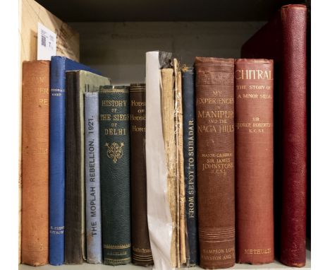
Younghusband (G.J.) Indian Frontier Warfare (Wolseley Series), 1st edition, 1898, 7 maps, including 5 folding (of which 2 are contained in pocket at rear), single-page of the Chitral Expedition 1895 printed in colour, original red cloth gilt, some marks and spine slightly faded, 8vo, together with other similar military history of India interest, 19th and early 20th century, including [W.W. Ireland], History of the Siege of Delhi, Edinburgh, 1861, George H. Hodson, editor, Hodson of Hodson's Horse or Twelve Years of a Soldier's Life in India, 4th edition, 1883, Sir James Johnstone, My Experiences in Manipur and the Maga Hills, 1896, Sir George Robertson, Chitral, The Story of a Minor Siege, 1898, D.C. Phillott, editor, From Sepoy to Subadar: being the life and adventures of a native officer of the Bengal Army, 3rd edition, Calcutta, 1911, Diwan Bahadur C. Gopalan Mair, The Moplah Rebellion, 1921, Calicut, Norman Printing Bureau, 1923 (1,000 copies printed), The Tourist's Guide to Lucknow, 1905, Johnstons' New Map of India with the Roads, Railways and Military Stations Noticed in the Insurrectionary Movements, Edinburgh, 1857, etc., mostly cloth bound, mainly 8vo (Qty: 12)

Lot 21
* Maps. A mixed collection of sixteen maps, 17th - 19th century, eleven maps of British counties and regions and three overseas, including three county maps by Robert Morden (Gloucestershire, Cumberland & Hampshire), Gloucestershire and Hampshire torn with loss, an uncoloured engraved map of Holderness by J. Tuke, a plan of 'Twelve Miles round Southampton with the Isle of Wight', sectionalised and laid on linen, a coloured map of the West Indies by J & C Walker, a map of North America by Keith Johnston, a map of Ireland by Tirion, a Mercator/Hondius of South West England and Wales and a Blaeu of Durham, framed and glazed, with others similar, various sizes and condition (Qty: 14)

Lot 10
Izacke (Richard). Remarkable Antiquities of the City of Exeter: Giving an Account of the Laws and Customs of the Place ... , now very much enlarged, and continued to the year 1724, by Samuel Izacke, 3rd edition, London: for the author, 1734, folding engraved map (repaired on verso), folding engraved plate, woodcut letterpress illustrations, some toning, a few leaves dampstained, all edges gilt, contemporary red morocco gilt, worn, joints cracked, 8vo together with: Risdon (Tristram) , The Chorographical Description, or, Survey of the County of Devon, with the city and county of Exeter ... , London: for E. Curll, 1714, defective (lacking all after leaf Q4), but with 'Some account of the family of the Spicers' at rear (as usual), some spotting, mainly at front and rear, modern quarter calf, 8vo, plus two others: An interesting narrative of the travels of James Bruce into Abyssinia to discover the source of the Nile, by Samuel Shaw, 4th edition, 1800; The letters of Junius complete in one volume, new edition, 1788 (Qty: 4)
Lot 127
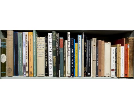
Desborough (V. R. d'A) . Protogeometric Pottery, 1st edition, 1952, Oxford, 38 monochrome plates plus folding map to rear, bookplate & period inscription to front endpaper, some minor toning, original blue cloth in dust jacket, covers slightly toned, large 4to, together with: Nairn (Ian) , Outrage, Counter-Attack Against Subtopia, both circa 1956, The Architectural Press, numerous monochrome illustrations, some minor toning, both in original illustrated boards, lightly toned & rubbed to head & foot, large 4to, and Mortlock (D. P.) , Holkham Library a history and description, 2006, Roxburghe Club, numerous colour & monochrome illustrations, original gilt decorated green cloth, large 8vo, limited edition of 100 copies, plus other miscellaneous art, architecture, antique, sculpture & photography reference, mostly original cloth in dust jackets, some paperbacks, G/VG, 8vo/4to (Qty: 53)
Lot 12
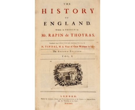
Rapin de Thoyras (Paul). The History of England ..., translated into English with additional notes by N. Tindal ..., 2 volumes, 2nd edition, London: for James, John and Paul Knapton, 1732-1733, vignette titles printed in red & black, lacking both portrait frontispieces, engraved maps, charts and tables (some folding), 1 folding map lacking lower portion (torn away), 1 folding table very creased and torn, large engraved vignette headpieces, rear of volume 2 with some dampstaining in gutters, some free endpapers detached, contemporary calf gilt, worn, joints cracked, folio, together with: Ecton (John) , Thesaurus Rerum Ecclesiasticarum, being an account of the valuations of all the ecclesiastical benefices in the several dioceses in England and Wales ..., 2nd edition, London: for J. and P. Knapton [et al], 1754, occasional ink manuscript annotations, title with ink ownership stamp (Rev M. P. F. R. Sparrow) at head, final printed leaf (nearly detached) with old repair at foot, some spotting at front and rear, front free endpaper (detached) with ink presentation inscription (to Montagu Pennington Sparrow) dated 1839, armorial bookplates of: Montagu Pennington Sparrow AM (at rear); Tho's Pennington AM of Bledlow, Bucks; and Cresswell Naesmyth of Posso, contemporary speckled calf, worn, front cover detached, 4to, plus: Bacon (John) , Liber Regis, vel Thesaurus Rerum Ecclesiasticarum, London: for the author by John Nichols, 1786, decorative tail pieces, variable spotting, free endpapers detached, front free endpaper with ink ownership inscription, armorial bookplate of Cresswell Naesmyth of Posso, contemporary calf, worn, both covers detached, thick 4to (Qty: 4)

Lot 17
Dugdale (Thomas). Curiosities of Great Britain. England & Wales Delineated, Historical Entertaining & Commercial, Alphabetically arranged, 11 volumes, L. Tallis, circa 1860, numerous uncoloured double-page maps by J. Archer and engraved views throughout, slight spotting, some hinges and joints cracked and weak, publishers green cloth gilt, faded and worn at extremities, 8vo, together with Bell (James). A New and Comprehensive Gazetteer of England and Wales, 2 volumes (only), A. Fullarton & Co., 1834, folding engraved map of England and Wales, several uncoloured double-page engraved maps by A. Fullarton , slight spotting and off-setting, publisher's green cloth, faded and worn at extremities, 8vo, with two volumes of 'Winkles Cathedrals' plus another five volumes of atlases and gazetteers including examples by Blackie, Landman, Stukeley/Moll and Baldwin & Thomas, all defective, various sizes and condition (Qty: 20)NOTESSold as a collection of maps and plates, not subject to return.

Lot 25
* Saxton (Christopher & Kip William). Northamtonia Comitatus Descriptio in quo Coritani olim in Sederunt, Notingamiae Comitatus olim pars Coritanorum [and] Cumbria sive Cumberlandia quae olim pars Brigantum, [1637], together three hand coloured engraved maps, Northamptonshire trimmed to neat line along vertical margins, each approximately 265 x 315 mm, framed and glazed, together with, Owen (Thomas & Bowen Emanuel), A Map of Middlesex [1720 or later], hand coloured engraved maps (three copies), each approximately 180 x 120 mm, framed and glazed, with Gardner (Thomas). The Roads from York to Whitby and Scarborough in Yorkshire..., [1719], hand coloured engraved strip road map, 175 x 270 mm, framed and glazed . (Qty: 7)NOTESNot examined out of frames.

Lot 208
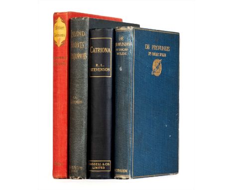
Wilde (Oscar). De Profundis, 1st edition, London: Methuen and Co., 1905, half-title, 40 pp. advertisements dated February 1905, contemporary ownership inscription (?Bertram Christian, Feb 1905' and adhesive staining from compliments slip 'from Mr. Robert Ross' to front free endpaper (slip loose), original cloth, 8vo, together with: Stevenson (Robert Louis), Island Nights' Entertainment, 1st edition, London: Cassel & Company Limited, 1893, frontispiece, sketch map, text illustrations, 16 pp. advertisements with date code '7 G 93', manuscript correction to price on list of works facing half-title, contemporary git inscription to front free endpaper, original cloth, 8vo, and 2 others (Qty: 4)
Lot 170
Folio Society . London Characters and Crooks, by Henry Mayhew, 1996, History of The Conquest of Mexico,..., by William H. Prescott, 1994, The Source of The Nile,..., by Richard F. Burton, 1993, includes facsimile folding map, William Russell Special Correspondent of The Times, by Roger Hudson, 1995, Meta Morphoses, by Ovid, 1995, together with 59 further volumes of Folio Society publications, some duplicate copies, all original cloth, 42 in slipcases, VG, 8vo (Qty: 64)


-
108737 item(s)/page