We found 109182 price guide item(s) matching your search

Refine your search

Year

Filter by Price Range
  • List
  • Grid
  • 109182 item(s)
    /page

Lot 90

West Indies.- Speed (John) A Map of Jamaica [on sheet with] Barbados, 2 maps on 1 sheet, each with decorative title cartouches, compass roses, ships and sea monsters, engravings with hand-colouring, 425 x 530 mm (16 3/4 x 20 7/8 in), English text verso, central vertical fold with minor browning, parallel printers' crease, small nicks and tears to extremities, two small worm holes in each of the lower corners, unframed, Bassett and Chiswell, [1676]

Lot 92

Ireland.- Malton (James) [A Picturesque and Descriptive View of the City of Dublin], engraved title, 2 aquatint plans, full-page aquatint vignette of the Arms of the City of Dublin, folding map of Dublin by William Faden dated 1797, and some text leaves only, lacking lacking dedication and without any of the 25 views of Dublin, the map sheet 530 x 780 mm (20 7/8 x 30 3/4 in), laid on linen and mounted in stub, some small loss to centre left restored, other repaired tears and surface dirt to map, otherwise damp-stains to title, plans and throughout, repaired tears and loss, surface dirt and scuffs throughout, largely disbound, lacking covers and spine, oblong folio, [circa 1792 and slightly later]; and another copy of the same, containing engraved title, 2 aquatint plans and text only, oblong folio (2)

Lot 93

Ireland.- A collection of 7 folding maps, extracted from Parliamentary Reports, together with some of the text reports, including three maps on developments to Phoenix Park, Dublin, and its environs, one of King's Island, Limerick, and others including one of Scottish interest showing River Tay, Dundee, lithographs, some hand-colouring, various sizes, some handling creases, minor off-setting, surface dirt, unframed, [circa 1844-1853]; together with Edward Stanford's Map of Ireland, lithograph printed in colours, 1020 x 805 mm (40 1/8 x 31 3/4 in), dissected and mounted on linen, some surface dirt and minor browning, folding with publisher's labels to ends, with original green slip-case with publisher's yellow label to upper cover, 8vo, [circa 1890s] (8)

Lot 94

Wales.- Ortelius (Abraham) Cambriae Typus Auctore Humfredo Lhuydo Denbigiense Cambrobritano, map of Wales, with details of mountain ranges, forests, and towns, strap-work title cartouche, sea monster, and ship off the coast, engraving with early hand-colouring, on laid paper with indistinct armorial watermark, platemark 375 x 495 mm (14 3/4 x 19 1/2 in), small margins, Latin text verso, some expert repairs to splitting and perforations, minor surface dirt, unframed, [Antwerp, circa 1590s].Literature:VdB 21

Lot 96

British Isles.- Blaeu (Johannes) Britannia prout divisa suit temporibis Anglo-Saxonum praesertim durante illorum Heptarchia, map of the British Isles, margins decorated with 14 scenes of Saxon figures and events, engraving with hand-colouring on laid paper with large armorial watermark, platemark 415 x 530 mm (16 1/4 x 20 7/8 in), under glass, minor spotting and surface dirt, framed, [circa 1645]

Lot 97

British Isles.- Blaeu (Johannes) Insulae Albion et Hibernia, Ptolemeaic map of the British Isles, engraving with hand-colouring, platemark 380 x 440 mm (15 x 17 1/4 in), central vertical fold with splitting to edge, marginal nicks and tears, some browning, off-setting, and surface dirt, unframed, [circa 1645].

Lot 98

British Isles.- Speed (John) The Kingdome of Great Britaine and Ireland, map with strapwork title cartouche, inset views of London and Edinburgh, small map of the Orkneys, and decorated with ships and sea-monsters, engraving by Joducus Hondius, with hand-colouring, 415 x 525 mm (16 1/8 x 20 3/4 in), English text verso, central vertical fold reinforced verso with careful repairs to splitting, some handling creases and minor restoration to extremities, unframed, William Humble, 1653.

Lot 99

British Isles.- Ortelius (Abraham) Britannicarum Insularum Typus, map of Roman Britain based on information from Mercator's 1564 map of the British Isles, oriented with north to the right, three decorative strapwork cartouches, numerous sailing ships, engraving with hand-colouring on laid paper with crossed arrows watermark, platemark 370 x 510 mm. (14 1/2 x 20 in), sheet 435 x 550 mm. (17 1/8 x 21 5/8 in), Latin text verso, central vertical fold as issued, minor marginal nicks, some surface dirt and light browning, unframed, [circa 1595 or slightly later].

Lot 37

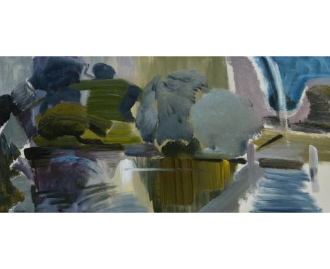
λ Ivon Hitchens (British 1893-1979)Wittenham Clumps from Day's LockOil on canvasSigned (lower left); further signed, titled and dated 1956 (on artist's label to stretcher)41 x 87cm (16 x 34¼ in.)Provenance:Acquired directly from the artist in 1957Thence by descent to present ownerSynonymous for his panoramic depictions of the English countryside, Ivon Hitchens learnt his trade at the Royal Academy Schools before setting up a studio in north London in 1919. The subsequent two decades saw the evolution of Hitchens' style from an accomplished but essentially traditional representational approach to a much more personal and emotive pictorial language. The influence of contemporary French painters such as Paul Cezanne, Georges Braque and Andre Lhote, as well as friendships with confirmed modernists like Claude Flight exposed Hitchens to new and exciting ways of seeing. An invitation to stay with Ben and Winifred Nicholson at their house in Cumberland in 1925 led to a productive exchange of ideas at a time when all three were at a critical juncture in their artistic development. The paintings that Hitchens completed during this time have often been seen as the first in which his personal style begins to manifest itself. These years were, however, a financial struggle for Hitchens who, lacking any significant patronage, had to be content with only selling a handful of works each year. The one constant was his membership of the Seven and Five Society. With its first exhibition in 1920, the group was initially made up of a haphazard variety of artists, but Hitchens' suggestion that Ben Nicholson join the group in 1925, galvanised it into a more single-minded movement with a nascent modernist aesthetic. Over the coming years the group attracted many of the most innovative artists of the period including Christopher Wood, David Jones, Frances Hodgkins and Barbara Hepworth; and Hitchens' circle in north London grew to include further likeminded artists and intellectuals such as Henry Moore, Paul Nash, Adrian Stokes, David Bomberg, Walter Gropius and Herbert Read.In 1940, the Hitchens family which now consisted of his wife Mollie whom he had married in 1935 and their young son, John, born in April of the same year, were forced to retreat from London after his Hampstead studio and home was bombed. The couple had been spending increasing time in Sussex and the previous year had acquired an area of woodland near Lavington Common, along with a large caravan purchased from a Miss Williams of Heyshott for £20. This move to Sussex transformed Hitchens' painting and he spent the next forty years depicting the surrounding landscape.By the time of the present work, Wittenham Clumps from Day's Lock, executed in 1956, Hitchens had established himself as one of the foremost painters of the day, with financial security from a now longstanding relationship with Leicester Galleries and critical acclaim from several museum exhibitions. In the same year, he was chosen to represent Britain at the XXVII Venice Biennale. Whilst his work had been exhibited abroad, the Biennale offered an unrivalled opportunity for twenty canvasses to be shown, showcasing his work to a much wider international audience. The works were well received and, following the show, the British Council was invited by several European galleries, to send them on tour, garnering yet more exposure for Hitchens' work. Wittenham Clumps from Day's Lock is a superb example of Hitchens' use of colour to create form. The typical sage green interspersed with greys, whites and violets draw the viewer over the water to the landscape beyond. The intersecting lines of the foreground contrasting with the curve of the hills in the distance creating a sense of balance and harmony. The work was acquired in 1957 as a wedding present directly from Hitchens' studio and has remained in the same family ever since. The family have retained not only the original correspondence with Ivon Hitchens setting up the studio visit and subsequent purchase of the work but also a brilliant recollection of the visit by the original owner. These documents reveal him to be a solicitous and kindly man who was more than happy to devote the whole day to showing paintings to his prospectus buyers and discussing them at length. Although the letters deal mainly with the practicalities - including a hand drawn map of how to find the studio - they also reveal humour and sensitivity. Hitchens first letter, dated January 25th 1957, worries "Hadn't you better count your pennies after your honeymoon?".The timing of the visit coincided with the opening of Hitchens' exhibition at the Musée National d'Art Moderne in Paris and he remarks:"...it's odd how you can travel thousands of miles, do and see so much and find time for it all - while if one stays at home, things crowd in so thick and there is so much to attend to that I am usually behind with the delivery of paintings. Our Paris trip which did materialise in the end, leaves a hazy memory of floods of taxis (petrol rationing a myth), crowds of people, champagne adlib(?) and miles of stone floor galleries. The show looks well and everyone seemed pleased including the museum authorities who talk of buying one."The owner's memoir reveals more about the visit and includes a great many insights into Hitchens' working process."He seemed in no hurry, and curiously objective about his own work as though he were an outsider seeing it for the first time. Many canvasses were unfinished. He explained that he always knew what he was going to try to achieve but never how he was going to get there. He always started from nature (or from an interior or model). The first rendering was often relatively representational, the verticals and horizontals, light and shade, re-producing what was in front of him - up to a point.Each succeeding state - and he sometimes did 6 or more - would be more abstract, until the final one might, if he were 'lucky' express something of what the original meant to him, though, to the viewer, it might seem to be totally 'abstract' unless he knew how it had evolved."It was only after some considerable time that they came close to making a decision on a painting and, remarkably, the day ended with them agreeing on not just one painting but two:"We spent the whole afternoon, looking at and discussing painting after painting. Eventually the choice was narrowed to two; one I liked, one Hitchens liked and wanted us to have. The one I liked was not, Hitchens said, finished - or satisfactory. The one Hitchens preferred had just been completed - 'Wood Landscape no. 2', of 1956. He looked again at the one I preferred - 'Day's Lock, Wittenham Clumps' - and agreed there was something missing on the right-hand side. Picking up a large brush dripping with a characteristic mixture of grey, light blue and purple, he swirled in a sort of arching rainbow against the deep blue of the sky on the right. "There", he exclaimed, "That does it, I think". I wanted the picture more than ever, but he still wanted us to have the other. We explained that we were broke and could not possibly afford both. After long discussion, "I'll tell you what", he said, "why don't you take both - for the price of one". And, despite our protests, that is what eventually happened." 

Lot 111

COLLECTION OF VINTAGE RAILWAY BOOKS AND MAGAZINES INCLUDES UNDERGROUND RAILWAY MAP, TALES OF THE OLD RAILWAY MEN AND LOCOMOTIVES OF THE GREAT WESTERN RAILWAY, ALSO TO INCLUDE A MALLARD 4468 LNER MODEL FIGURE ETC

Lot 577

BRAUN & HOGENBERG; 'Cestria (Vulgo) Chester, Angliae Civitas', a circa 1575 hand coloured map of Chester, with text titled 'Cestria' verso, 31.5 x 42.5cm, framed and glazed.Additional InformationBrowning, slight waviness to paper, some pinprick holes, central fold, slight separation lower centre of fold, general wear to frame, crack to glass reverse lower right. Staining and discolouration throughout the image. There is an old rip to the centre right of the image. Measurements including frame 42 x 54.5cm. As catalogued, this is an original map.

Lot 1084

A late 18th/early 19th century map of Kent by Cary, 21.5cm x 27cm.

Lot 680

A selection of militaria objects to include a WW2 period saw, a war period document/map tube and a US vehicle stirrup air pump with battlefield handle

Lot 708

A WW2 cloth backed technical diagram for the lubrication of an armoured car A.E.C together with a French military map for Camp Sissonne in Nord de Guerre

Lot 731

Some vintage pamphlets and maps to inc. Burnets Ideas for Historical Costumes, Paris et ses Monuments, Pictorial Plan of London and a map of Lake Lucerne

Lot 769

A Bacon's 'New Chart of The World' linen backed folding map

Lot 796

A plan map of the Siege of Corfu by Jean Baptiste Homann, Nuremberg 1716 - unglazed, 49 x 57cm

Lot 166

A John Speede coloured map of Shropshyre, dated 1403, framed and glazed front and back, having an mahogany frame with integral handles to use as a tray, 15ins x 20ins

Lot 169

An Antique hand coloured road map, The Road From Oxford to Bristol, 6.5ins x 8.75ins

Lot 172

John Speede, The Bishoprick and Citie of Durham, dated 1346, glazed front and back, 15ins x 20ins, together with Robert Morden, a hand coloured map of Scotland, 16.75ins x 13.5ins, 

Lot 173

J Blaeu, Darbiensis Comitatvs vernacule Darbie Shire, a hand coloured map of Derbyshire, 20ins x 23.75ins

Lot 413

Flight Officer D W McBride, RAF 1939 Burma Star, 1939-45 War Medal together with escape map, peace flag, cigarette case and ampoules tin, all in a chocolate box

Lot 279

An original Welsh Valley and Cardiff lines Railway Network map. The framed map showing all local train routes departing from Cardiff with station stops translated into both Welsh and English. Measures approx 63x45cm

Lot 400

A WWII Second World War interest medal group and archive of related effects, to one 158222 Captain (later Major) William Gordon Tollworthy of the Royal Engineers who served in Burma from 1942-45 and was head of Military Intelligence in Perak (and took part in Operations Juno and Jetsam) as part of The Malayan Emergency in 1956-58. The medal group comprising; Military Cross, 1939-45 STar, The Burma Star, Defence Medal, War Medal (with oak leaf for a mention in despatches), QEII General Service Medal (with Malaya clasp and impressed Capt WG Tollworthy MC RE), George VI Territorial Efficiency Medal (impressed ditto) and Pangkuan Negara medal (Order Of The Defender Of The Realm). All with ribbons, and mounted on bar, and with their original set of miniature medals. The Military Cross comes with its original citation which, in part, reads; 'During the operations of 51 Indian Infantry Brigade at KANGAW from 27th January for a period of fourteen days, constantly under fire of every nature, he worked with unfailing energy and determination, both by day and by night with little rest. He frequently visited all areas from the beach to the forward troops, supervising the landing of heavy equipment, the development of water points, the construction of bridges and tracks and the demolition of enemy bunkers and ammunition dumps.' The medal group comes with a wealth of paperwork, effects and history - all related to Tollworthy, and includes;  - Tollworthy's Perak Combined Operations Room Pass - A box of Tollworthy's cap badges, uniform patches and other such items - A small silver white metal presentation statue engraved 'Presented To Major W.G. Tollworthy 63 Ind. Fd. Coy. Burma 1944-1945' - a post-war presentation Kundo mantel clock engraved to the top ' Presented To Major WG Tollworthy MCRE by 39 FD SQN RE, 8th Sep, 1960' - a typed copy of ' The Military Memoirs Of Major WG Tollworthy ' - based on tape recordings made by his family in 1996. The memoirs detailing his entire life and military career in great and personal detail. Also included are several copied drafts of the memoirs. - an original captured C96 'Broomhandle' Mauser detachable wooden stock / pistol case (no pistol present) - Five folders of period-written (mostly handwritten) documents written by Tollworthy during Operation Junto (some marked 'Top Secret') - includes some letters written by those arrested, various official documents, orders, notes, letters etc. As well as copious handwritten notes, encounters and other such entries.  - a 'Confidential' marked map showing the District Boundaries in Perak Police Contingent Operational Area with hand-drawn additions by Tollworthy - an original edition of 'In Defence Of Singapore - A Series Of Drawings With Brief Notes' - an envelope of photographs of Malayan soldiers / civilians - each with code numbers present to the images (presumably for identification purposes) - Various handwritten lists of ' Jetsam Surrenders ' - which appears to detail the individual details of those who surrendered during Operation Jetsam (some marked 'Surrendered To SAS'), - Photocopies of 1930s / Wartime sketches that Tollworthy drew in a friend's autograph book (with accompanying letter) - Tollworthy's 1919 dated hallmarked silver miniature tankard (likely a Christening tankard) - A large box-file of maps, documents and other items relating to the Policing of Perak and other such items including details of communist terrorist captures, interrogations, and captured CT hand-drawn maps of jungle routes, camps etc. - a quantity of intricately drawn jungle maps confiscated from terrorists during Junto - various paperwork relating to his MC including the official letter from King George An interesting piece of history within the collection is perhaps a copy of an original Japanese diary that Tollworthy once discovered when on service in the Burmese jungle during WW2. Tollworthy kept hold of the diary for many years, and in the 1990s - with the help of The Daily Telegraph - Major Tollworthy was able to reunite the diary with the family of its original owner. Lots of documents relating to the diary are included, as well as a photocopy of the entire diary itself, and a photograph of Tollworthy with the Japanese family who came over to visit him. Newspaper cuttings and related letters are also present. The entire archive makes fascinating reading, and is perhaps the most poignant factor in the collection. (more can be read about the diary here: www.olioo-me.medium.com/never-forget-that-of-250-only-20-survived-diary-of-emon-tochio-9ccfe41780f4) The entire collection - which must be considered as Tollworthy's complete military career archive from 1942-1965 - is one of the most interesting, and most important collections we have ever seen. A truly unique archive, with well over 500 individual documents and supporting items of great historical importance. 

Lot 617

The Dam Busters (1955) - collection of memorabilia relating to the film, and the real-life Operation Chastise. The collection comprising: an original autographed photograph of Richard Todd (framed with Dam Buster related cuttings), an original advertisement for the movie, and an original 1940 War Revision issue paper map showing Lincoln, including RAF Scampton. Interesting collection. 

Lot 65

WWIl Interest - an unusual RAF type ' Secret Map Domino ' comprising of a secret map hidden within a period domino. The top faux ivory-section removes to reveal a small section of a map showing Germany and Poland. A fascinating display piece.

Lot 659

A collection of WWII Second World War (and other periods) related ephemera, to include; a ' Meet The US Army ' pamphlet, photograph of a soldier, an original ' Join The New Regular Army ' recruitment poster, Fifth Army Commendation, map, a 1950s handwritten diary and other items. Interesting assortment. 

Lot 680

A WWII Second World War related silk ' escape ' map of France and Germany. Double sided. 1:2,350,000. Shows all main roads, canals and railways during the period, as well as various Prisoner Of War camps, escape routes etc. Undated, but appears to show c1943. Measures approx; 45cm x 63cm. 

Lot 692

Of WWII Second World War Interest - an 'escape and evade' British SOE type 1930s Rajar No.6 folding bellows camera, with hidden escape items in the rear compartment, to include; a miniature brass 'escape' compass, various French coins, and a folded tissue paper map. Likely once on display. Such items were known to be smuggled by the British Government to stranded RAF Airmen or soldiers in German occupied territory / POW camps. 

Lot 746

Two original WWI First World War period British Army issued maps of France, both named and owned by one Captain R. M. Huntrods of Durham Light Infantry. One 20,000 foot scale map and a second larger scale map: St. Pol area. France Sheet 36B SW, edition 6, published by the Ordnance Survey 1916. Coded in the bottom l/h corner GS GS 2742. On folding linen on a scale of 1:20,000. Size 90 by 68 cm. A key includes roads, railways, footpaths, churches, chimneys, windmills etc. The map does not show trenches but an area just to the west of Arras. An unusually clear and crisp map. Original owner’s name and rank to front of map. The owner served in the Durham Light Infantry and the Northumberland Fusiliers., and was wounded in France. The second map of part of France: Senleques-Lottinghem area. France Sheet 36D Western Half. Published by the Printing Section, Depot FSC., RE. GHQ (1701). No date. Information in the bottom l/h corner states: This map is an enlargement from the French 1:80,000 its accuracy cannot be guaranteed. Scale 1:40,000. Size 58 by 51 cm. On folding linen. Includes villages to the west of Arras including Bourthes and Zoteux. Original owner’s name in ink to front cover. The owner served in the Durham Light Infantry and the Northumberland Fusiliers and was wounded in France. Rare named maps. 

Lot 852

A collection of x3 original WWI First World War period British Army used maps of France and Belgium. Comprising:First World War British Officer’s map of part of France. France Sheet 11, Lens edition 2. Published by the Ordnance Survey in 1916. Coded in the bottom l/h corner GS GS 2364. On folding linen size 85 by 65 cm. Scale 1:100,000. A key includes details of roads, railways, mines, ruins, canals, churches, forts etc. In colour. Original owner’s name to the front cover. The owner served in the Durham Light Infantry and the Northumberland Fusiliers., and was wounded in France Area covered includes Arras and Bapaume.British Army map of Hazebrouck, published by the Ordnance Survey, Southampton for the Geographical Section General Staff  1915. Code 2364 to bottom left corner. On folding linen size 88 by 66 cm. Scale 1.100,000. Key gives information on many geographical features and has an explanation of French names for them. A very detailed map. VG condition.World War One Map British Army Map Belgium sheet 12: Valenciennes with Cambrai. Published for the British General Staff Geographical Section by the Ordnance Survey, Southampton May 1915. Scale 1:100,000. On folding linen. Name and stamp of the RE 73rd Field Company to the front of the map. Some annotations to the margins including details of the advance of the 21st Division from August to November 1918 and of the enemy captured. Good to VG condition.

Lot 879

A WWII Second World War British RAF / Military silk escape Map, 1944. South-east Asia sheets 44 J and K. Two back-to-back escape maps on one folding silk map. Size 95 by 60 cm. Scale 1:000,000. Folds to pocket handkerchief size or smaller. Side J covers French Indo-China (central), Siam (Thailand east) and side K covers an area of French Indo-China (south), Siam (Thailand- part). Maps are in colour with a colour-coded key to heights and a conventional key to features such as mountains, islands, railways, stations, ruins, post offices, roads etc.

Lot 252

Pete Conrad Two lunar views:1) View to southwest from the Lunar Module (from a panorama sequence)19 November 1969 EVA 1Vintage chromogenic print on fibre-based Kodak paper, 20.3 x 25.4 cm (8 x 10 in), [NASA AS12-46-6772] with A KODAK PAPER watermarks on the verso (NASA / North American Rockwell)2) Large mound near ALSEP19 November 1969 EVA 1Vintage chromogenic print on fibre-based GAF paper, 20.3 x 25.4 cm (8 x 10 in), numbered with NASA number AS12-46-6795 in margin (NASA / USGS)Footnotes:'The craters are hard to see. They look great on a map, but they don't look worth a damn when you're running along next to them. You can't judge distance, and you can't tell how far you've run, because you've never run on the moon. So not only can't you guess the distance, if you've been running for fifteen seconds, you don't know if you've covered fifty yards or fifty feet.' Alan Bean Condition Report: 1) Photo AS12-46-6772: a narrow stain along the left edge, otherwise good; 2) Photo AS12-46-6795: age toning and some dump stains to upper and lower margins (can be mounted out)Condition Report Disclaimer

Lot 212

ROYALTY, Coronation selection, George VI (7+1) & Elizabeth II, inc. programmes, Dorothy Wilding silk, Gideon bookmark, map etc., G to EX, 16

Lot 249

CHURCHMANS, odds, inc. Footballers, Fish & Bait, Flags & Funnels, Boys Scouts, Dogs & Fowls, Sectional Cycling Map, Birds & Eggs, Tour Round the World etc., FR to generally G, 92*

Lot 73

TRANSPORT, first Macdonald Gill London underground map, dated 1920, small split to two folds, G

Lot 507

TRAY OF COPPER PRINTING PLATE, VINTAGE ADVERTISING TINS, 19TH CENTURY SNUFF BOX , SHEAFFER PEN SET, AND A PRACTICAL MOTORIST MAP MEASURER (TRAY NOT INCLUDED)

Lot 536

SMALL OIL ON CANVAS OF COTTAGE BY RIVER, PAIR OF JAPANESE PRINTS, PRINT AND FACSIMILE MAP OF WARWICKSHIRE

Lot 415

Pair: Private W. J. Sandford, Tank Corps, who was killed in action on the Western Front on 25 August 1918, during an act of heroic self-sacrifice as he succeeded, at the cost of his own life, in rescuing four of his comrades from a burning tank, for which act of gallantry he was strongly commended British War and Victory Medals (109780 Pte W. J. Sandford. Tank Corps); Memorial Plaque (William Joseph Sandford) in card envelope, with Buckingham Palace enclosure, extremely fine (3) £240-£280 --- William Joseph Sandford was born in Worcester and attested there initially for the Royal Army Service Corps, before transferring to the Tank Corps. He served with the 11th Battalion during the Great War on the Western Front, and was killed in action on 25 August 1918, whilst performing an heroic act of self-sacrifice in an attempt to rescue wounded comrades. An Appendix to the Battalion War Diary for 25 August 1918 states: ‘From:- Lieutenant F. A. Burton, No. 5 Section, “B” Company, 11th Tank Battalion. To:- Officer Commanding, 11th Tank Battalion. Sir, I have the honour to submit the following report in connection with the action at Boyelles on 23 August, 1918, in which I was wounded and taken prisoner. Orders were received from Battalion Headquarters for “B” Company to leave Blairville Wood about 10:30 p.m. on 22 August, and proceed to the front line, distant about 6 kilometres. I was in command of Tank No. 9659. The first driver and the first gunner were taken to the line by car in order that they might rest before going into action. On arrival within 2km of the line the Company had to pass under enemy shrapnel fire and all ranks were ordered to remain in their tanks until the shelled area was passed. The Company arrived in the vicinity of the “Jumping off” place about 6:15 a.m. when an enemy aeroplane was sighted and orders were received to shut down engines and camouflage tanks at once. The action was to commence at 7:00 a.m. Owing to the time taken in camouflaging, greasing, filling up, etc., the reconnaissance of the battle area had to be limited to a rather hurried discussion over a map. There was no time for Tank commanders to examine the ground over which they had to travel. The first driver and first gunner arrived just as our barrage was opened. All tanks were immediately uncovered and started into action. The Orders received by me were as follows:- Tank (9659) was to be the right hand tank of the section. On the crest of the hill about 1,000 yards distant was our front line, and on top of the next crest was the enemy front line (about 700 yards from ours). The tanks were to start after the infantry, overtake them, then cross the enemy front line and patrol it until the arrival of the infantry, after which all tanks would proceed as quickly as possible to the rallying point. The crew of the tank with the exception of the first driver and the first gunner, having been on the move all night, were more or less fatigued, and the tank was very hot. As the action proceeded the heat inside the tank became intense. On crossing the enemy front line my first driver (Corporal Hammond) and first gunner (Lance-Corporal Watkins) were killed by A.P. bullets, and whilst they were being replaced the tank received a direct hit through the front which stopped the engine and set the tank on fire. I remember nothing more until I found myself lying in a shell hole alongside the tank, and discovered that I was wounded in the right leg. The tank was burning furiously and continuous explosions of the 6 pdr. and S.A. ammunition occurring With me in the shell hole were three other survivors, Gunners Hurd, Goozee and Clark, all wounded. Gunner Clark informed me that he had been carried from the burning tank by Gunner W. Sandford, who, up to that time, was unwounded. This gallant action was performed under the heavy machine-gun fire which was being concentrated on the tank. On entering the tank again to see if he could effect further rescue Gunner Sandford was killed, presumably by the explosion of the ammunition in the tank. This statement is corroborated by the other survivors. I strongly commend to your notice the gallant conduct of Gunner W. Sandford.’ There were many cases of gallantry that, for whatever reason, went un-rewarded during the Great War, and Sandford ultimately received no medallic recognition for this gallant act. He has no known grave and is commemorated on the Vis-en-Artois Memorial, France. Sold with copied research

Lot 460

North West Canada 1885, no clasp (Pte. Samuel Taber, Alberta Field Force.) contemporarily engraved naming, extremely fine £300-£400 --- Samuel Taber served with the North West Mounted Police from 1873-79, and was an original Mounty on the march west, being mentioned twice in Steele’s Book of Reminiscences. Discharged from the North West Mounted Police, he was an original member and builder of Fort Saskatchewan, and the 1883 map of Fort Saskatchewan shows him as the owner of Lot 3 on the south side of the river. Taber served with the Alberta Field Force during the Riel Rebellion, and his medal was sent to the Deputy Minister, 10 February 1899. Sold with a fair copy memo regarding to the recipient’s discharge from the North West Mounted Police.

Lot 474

Queen’s South Africa 1899-1902, 3 clasps, Natal, Orange Free State, Transvaal (3833. Pte. J. Knight, Glouc: Regt.) minor edge bruise, toned, very fine £300-£400 --- J. Knight attested for the Gloucestershire Regiment and served with the 1st Battalion in South Africa during the Boer War. He was taken Prisoner of War at Farquhar’s Farm on 30 October 1899, when his Battalion got ahead of the main relief body of the relief of Ladysmith. He spent ten months as a Prisoner of War before being released., during which he suffered from bad or little food. In England various charities were set up to raise money to purchase food parcels for British Troops and British Prisoners of War in South Africa. One such charity, ‘The Absent-Minded Beggar Fund’, raised money by the sale of memorabilia, one of the more iconic items being the Boer War handkerchief, depicting the Boer War on a map of South Africa, which was priced at 1 shilling sixpence. Sold together with two framed ‘The Absent-Minded Beggar Fund’ handkerchiefs, each showing words by Rudyard Kipling and music by Sir Arthur Sullivan, together with a map of South Africa showing the principle settlements, and portraits of Queen Victoria and Field Marshal Lord Roberts, both mounted in glazed display frames, each measuring 500mm x 500mm; and copied research.

Lot 3025

Guicciardini map from 1612 of the city ‘S HERTOGENBOSCH, published by W.J. Blaeu. Sold with two engravings of cityplans and a modern aquatinto. The first: With the coat of arms of Brabant in the upper left corner, and the city’s coat of arms in the upper right corner with the title in between. A scroll cartouche in the bottom right corner with Latin text. Copper engraving, published in 1612 in Amsterdam by Willem Jansz. (= Blaeu) in "Beschryvinghe van alle de Nederlanden; (.)", Lodovico Guicciardini. Estimate: € 30 - € 50.

Lot 2

An interesting Knight Bachelor’s group of three awarded to Lieutenant Sir Sydney C. T. Littlewood, Royal Flying Corps, later Chairman of the Legal Aid Committee of the Law Society, who, tasked with delivering a brand new F.E. 2D aircraft to the Western Front on 1 June 1916 on what was his first operational flight, lost his way and inadvertently landed at a German aerodrome, where he was captured and taken Prisoner of War- an episode that was raised and debated in the House of Lords Knight Bachelor’s Badge, 2nd type breast badge, silver-gilt and enamel; British War and Victory Medals (Lieut. S. C. T. Littlewood. R.A.F.) mounted for display purposes in a display frame, together with a Royal Flying Corps silver and enamel sweetheart’s brooch, good very fine (3) £600-£800 --- Knight Bachelor London Gazette 7 June 1951: Sydney Charles Thomas Littlewood, Esq., Chairman, Legal Aid Committee of the Law Society. Sir Sydney Charles Thomas Littlewood was born at Bournemouth, Hampshire, on 15 December 1895 and following schooling embarked upon legal training. A keen pilot, he gained his Royal Aero Club Certificate (no. 1755) at Hendon on 16 September 1915, and was commissioned Second Lieutenant in the Royal Flying Corps on 17 May 1916. Whilst waiting for a Squadron posting, the War Office sent a message that two FE pilots were required to ferry planes to Squadrons already in France. There was a misunderstanding somewhere, and the planes to be ferried were not ordinary F.E.’s, but the brand new F.E. 2D. When Littlewood discovered this he pointed this out, explained that he was an inexperienced pilot, and that he was unsure of the way to France, never having been there before. Told that there were no spare pilots available, he was given a map and told to get going. On 31 May 1916 Littlewood and his observer, Lieutenant D. L. Grant, left Farnborough for France. They were reported flying over the Allied lines at Armentieres, before disappearing in the direction of Lille. The plane and the crew were posted missing, but on the evening of 1 June 1916 a German wireless communiqué stated, somewhat sarcastically, that an FE had crossed German lines and had descended undamaged at a German aerodrome near Lille after the pilot had lost his way, and that both the pilot and observer were in the hands of the Germans. The enemy further thanked the British for the aircraft, which they said would be ‘most useful’. Imprisoned as a prisoner of War in Holziminden for the remainder of the War, Littlewood was finally repatriated on 3 January 1919. The whole episode surrounding the loss of Britain’s newest aircraft, in enemy hands barely three hours after it had left the factory, was subsequently debated in the House of Lords. Resuming his legal training on the cessation of hostilities, Littlewood was admitted as a Solicitor in 1922, and served as Senior Partner in the firm of Wilkinson, Howlett & Moorhouse. He was a member of the Council of Law Society from 1940, and served as Chairman of the Legal Aid Committee from 1946 to 1952, receiving a Knighthood for his services in 1951. He was appointed vice President of the Law Society in 1958, and died on 9 September 1967. Sold with a large quantity of copied research, and various photographic images of the recipient.

Lot 594

After Hondius. Map of Lincolnshire, showing various coats of arms, etc., 39cm x 51cm.

Lot 615

A collection of maps, relating to Norfolk, road from Norfolk and Suffolk, a map of Norfolk drawn by Creighton, and a similar map of Suffolk (3).

Lot 616

After Dugdales. A map of Nottinghamshire. and a map of Lincolnshire (2).

Lot 1473

A Victorian watercolour of a hillside cottage, together with a sampler, a map, an engraving by Basil Bradley and other works

Lot 1500

Benjamin Rees DAVIES (1789-1872)CORNWALL With Cheese Wring, Scilly and compass rose. Larger Version. Cornwall Illustrated In A Series of Views (Fisher and Son)40 x 49cm together with a Cary map of Cornwall (reprint) (2).

Lot 1501

Map, handcolouredEman. BOWEN (1694-1767)Shrop Shire 51.5 x 70.8cm

Lot 1502

Map, handcolouredEmanuel BOWEN (1694-1767)An Accurate Map of Bedford divided into its Hundreds c.1749 70 x 52.3cm

Lot 150A

A VINTAGE MAP MEASURER WITH ORIGINAL BOX

Lot 2156

An early 19th Century black and white engraved map of Wiltshire by Fullarton & Co, gilt frame

Lot 2192

An early 19th Century engraved map of South Wales by J & C Walker, in oak frame, gilt mount

Lot 2428

A framed map - Calais to Dover, circa 1900

Lot 2432

An early 19th Century hand coloured map of the US, showing the open railways

Lot 2433

An early 20th Century map of Leeds by J. Bartholomew

Lot 1005

John Speed, an engraved and hand tinted map of Cumberland inset with a plan of Carlile, 42cm by 54cm, together with Johannes Blaeu, an engraved and hand tinted map of Westmorland, 45cm by 57cm (2)

Lot 1010

Robert Morden, an engraved and hand tinted map of Cumberland, 39.5cm by 45.5cm, John Cary map of Westmorland and a further two printed maps (4)

Lot 1012

Robert Morden, an engraved and hand tinted map of Somerset (shire), 37cm by 43cm, the Kingdom of Ireland, 42cm by 36cm and another a correct map of Buckinghamshire, 15cm by 17cm (3)

Loading...Loading...
  • 109182 item(s)
    /page

Recently Viewed Lots