
Wheler (George). Voyage de Dalmatie, de Grèce, et du Levant ... traduit de l'anglois, 1st edition in French, Amsterdam: Jean Wolters, 1689, additional engraved title-page (counted in register), 8 double-page numismatic plates, 5 plates of inscriptions (of which 4 folding), folding map, 72 further plates, small hole from quire Y to end (quire 2D) and intervening plates, repaired closed tear to folding plate of inscriptions facing p. 483, plate at p. 491 chipped along fore edge, contemporary ownership inscription 'J. D. Boudrit' to front free endpaper, contemporary vellum, dust-soiled, 12mo (14.6 x 8.8 cm), together with: Clüver (Philipp), Introductionis in universam geographiam ... accessi P. Bertii Breviarum orbis terrarum, Utrecht: Willem Broedelet, 1701, signatures *6 A-S12 T4 (-T4), engraved title-page, 39 engraved folding maps (of 41), spotting to quires * and T, leaves of quire * slightly brittle and chipped, light spotting along blank margins of maps and occasionally to text-leaves, map of Italy at p. 131 partially separated along one fold, map of Africa at p. 269 with a few holes along fold, contemporary calf, rebacked and recornered, 12mo (13.2 x 7 cm), [Loredano, Giovanni Francesco], Historie de' re Lusignani, publicate da Henrico Giblet, Venice: Guerigli, 1679, additional engraved title (laid down with section of loss to margin), damp-staining, contemporary vellum, 12mo (15 x 7.8 cm), Vero (Giovanni Battista), Rerum Venetarum libri sex. Quarta impression, Padua: Typis seminarii, 1684, [14] 870 pp., front free endpaper excised, contemporary ownership inscription 'Ex libris Balthasaris Hippolito de Paradiso' to front pastedown, contemporary vellum, dust-soiled, 12mo (14.3 x 7 cm) (Qty: 4)NOTESBlackmer 1787 (Wheler); Cobham-Jeffery p. 23 (Loredano). Wheler's work was first published in 1682 as A Journey Into Greece and 'remained the standard book on Greece for many years' (Blackmer). Loredano's work first appeared in 1647; OCLC traces two copies for this edition world-wide. The first quire in Vero's work is irregularly signed but the 14 preliminary pages correspond to other copies we have located.
We found 109182 price guide item(s) matching your search
There are 109182 lots that match your search criteria. Subscribe now to get instant access to the full price guide service.
Click here to subscribe- List
- Grid
-
109182 item(s)/page
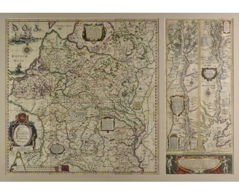
* Poland & Lithuania. Blaeu (Willem Janszoon), Magni Ducatus Lithuaniae Caeterarumque Regionum illi Adiacentium Exacta Descriptio..., [in set with] (Dnieper River), Amsterdam, 1613 - 1635, wall map, engraved by Hessel Gerritsz from drafts prepared by Prince Nicolas Radziwill, contemporary outline colouring, on four conjoined sheets, showing Lithuania and parts of Poland, Russia, Ukraine and Latvia, extending to Cracow, Kiev, Warsaw, Riga, Konigsberg, Dantzig and Leopolis, 750 x 740 mm, mounted with its companion sheet showing the course of the River Dnieper, this map on two conjoined sheets with contemporary outline colouring, old folds, 750 x 325 mm, double aperture mount, framed and glazed (Qty: 1)NOTESThe first map provides a great deal of information on cities and towns of all sizes, political boundaries, and the extensive system of rivers in the region. Also included are a number of historical notations and two vignettes illustrating important battles west of Smolensk and between Braclaw (Bratslav) and Cherkasy (at bottom right). The map is decorated with several cartouches, three galleons and a sea monster in the Baltic Sea, a large compass rose, and a distance scale. The map detailing the course of the Dnieper River extends from Cherkasy to the estuary on the Black Sea. The map is in two vertical strips which follow the course of the river. It is decorated with cartouches and compass roses and includes descriptions of cataracts, cities, salt mines, fortresses, and the historical traditions of the Kozaks. The large cartouche at the base of the map is flanked by putti. It is rare to find the two maps together and extant.

British Isles. Blaeu (Johannes), Insulae Albion et Hibernia cum minoribus adjacentibus, circa 1645, engraved map with contemporary outline colouring, old ink stain affecting image, slight creasing, old blind-stamp just affecting image, old library stamp to verso, 380 x 445 mm, Latin text to verso, together with Anglia Regnum, [1645 or later], hand coloured engraved map, slight creasing largely confined to margins, some marginal staining, 385 x 500 mm, no text on verso, with Mercator (Gerard). Anglia Regnum, circa 1613, engraved map with contemporary outline colouring, toned overall, one wormhole in margin, one small rust stain affecting image, 350 x 460 mm, French text on verso (Qty: 3)
Pardoe (Julia). The Beauties of the Bosphorus, circa 1840, 2 additional engraved titles, two portraits, 3 engraved maps, 162 steel-engraved plates after W. H. Bartlett, some light spotting and marginal toning, bound in 8 divisions in original red blindstamped cloth gilt, a few spines with tears and losses, 4to, together with: Carne (John), Syria, the Holy Land, Asia Minor, Illustrated, 3 volumes in 2, [1836-38], 3 additional engraved titles, engraved map, 117 steel-engraved plates after W. H. Bartlett, William Purser and others, some light toning, spotting and soiling, contemporary half morocco and diced calf, first volume covers detached and defective spine, rubbed, 4to, and others, including duplicate volumes of The Beauties of the Bosphorus & Danube (Qty: 31)NOTESSold as a collection of plates not subject to return.


* Holy Land. De Wit (Frederick), Terra Sancta sive Promissionis olim Palestina recens delineata et in lucem edita per, Amsterdam, circa 1680, engraved map with contemporary outline colouring, inset plan of the camp of the Israelites flanked by the figures of Moses and Aaron, trimmed to neatline, slight toning, 455 x 550 mm, mounted, framed and glazed (Qty: 1)

Brion de la Tour (Louis). Atlas General, Civil, Ecclesiastique et Militaire, Méthodique et elementaire pour l'etude de la geographie et de l'histoire..., 3rd edition, published Paris, 1772, decorative double page engraved title, index in contemporary manuscript on endpapers. long closed tear to front endpaper, seven engraved plates of globes, spheres and celestial diagrams, 45 (of 46, lacking the map of Europe) double-page engraved maps and 2 larger folding maps of France, all with contemporary outline colouring, maps re-guarded, map of the world with some marginal staining, occasional spotting, slight marginal dust soiling and finger staining, contemporary calf, heavily worn and frayed, 4to (Qty: 1)

A large map of India; the inscription reads "From all the latest authorities and intended more particularly to facilitate a reference to The Civil and Military Stations. Dedicated to Sir James Rivett Carnac Bart, Chairman of the Court of Directors of the Honourable the East India Company". Arranged under the direction of Captain R.M. Grindlay. The name "WYLD 1881 £200" written in pencil lower right. Published in London by James Wyld, Geographer to the Queen, 11 & 12 Charing Cross, S.W., pink mount with no glass, framed, approx 66 x 97 cms.

Three maps of India; the first entitled "India Proper or the Empire of the Great Mogul" by H. Moll,Geographer, approx 18 x 26 cms (io), glazed and framed, together with a map showing "A New and Accurate Map of the Southern Provinces of Hindoostan shewing The Territories ceded by Tippoo Saib, to the different powers", approx 23 x 28 cms (io) and a map depicting "Madras, Hyderabad, Mysore, Coorg and Ceylon, approx 16.5 x 19 cms, glazed and framed. (3)

AFTER MV DONLON "The Yorkshire Coal Field Memories", coloured print limited edition numbered 127 from 8,000 signed in pencil middle right together with AFTER EMANUEL BOWEN "An Accurate Map of the County of York Divided into its Ridings and Sub-Divided into its Wapontakes drawn from surveys with various improvements...", black and white engraving later coloured


A 19th Century folding map of England and Wales "Geological Map of England and Wales Reduced by Permission from the Map in Six Sheets" published by the Geological Society together with AFTER J. ARROWSMITH "The Inland Navigation Railroads Geology and Minerals of England and Wales", black and white engraved map later coloured circa 1834


A framed and glazed topographical study of Honsdon House inscribed "Matthew Bluck of Honsdon House Esq this draft is humbly presented by John Drapentier?", hand coloured engraving together with a 19th Century strip map "Kneesworth to Huntingdon", bearing the arms of Huntingdon and Script and AFTER EMMANUEL BOWEN for "Britannia Depicta", "The Road from Bristol to Worcester" copper engraving later hand-coloured, bears Margaret Edwards Maps & Prints label verso

AFTER EMANUEL BOWEN "An Accurate Map of the West Riding of Yorkshire Divided into its Wapontakes", black and white engraved folding map and later coloured together with AFTER EMANUEL BOWEN "The County of York Divided into its Ridings and Sub-Divided into Wapontakes", black and white engraved folding map and later coloured


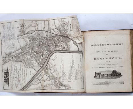
Williams (David) The History of Monmouthshire, 1796. 4to., cont. half black roan. Engraved map, and 36 hand coloured aquatints - Barber (JT) A Tour Throughout South Wales and Monmouthshire, 1803. 8vo., cont. tree calf. Map and sepia aquatint frontispiece (2)/Provenance: Spetchley Park/see illustration CONDITION REPORT: 275:Map lightly offset onto title. Plates clean. Barber, plates and map clean
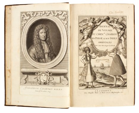
Chardin (Sir John) Journal du Voyage…en Perse et Aux Indes Orientales. Premiere Partie (all published). First Edition, 1686. Folio, cont calf. Engraved title, portrait, folding map and 14 folding plates (one torn)/Provenance: Spetchley Park/see illustration CONDITION REPORT: 280:Clean internally, good.
![[Chanlaire Pierre-Gregoire] Geographie Precis Elementaire de la France. Paris 1791. Oblong 4to., cont. half calf (worn, cover](https://cdn.globalauctionplatform.com/9b8fb99b-e665-4f6a-b5b7-ab3600b3ff48/7018d7af-6558-4df0-b614-ab3c00cf17d9/468x382.jpg)


![[Young Arthur] The Farmer's Tour Through the East of England, 4 vols., 1771. 8vo., cont. calf (wear to sides, lacks 3 labels)](https://cdn.globalauctionplatform.com/9b8fb99b-e665-4f6a-b5b7-ab3600b3ff48/5dd16cd3-5cec-402a-be6a-ab3c00cf483a/468x382.jpg)
[Young Arthur] The Farmer's Tour Through the East of England, 4 vols., 1771. 8vo., cont. calf (wear to sides, lacks 3 labels); A Six Months Tour Through the North of England, Second Edition, 4 vols., 1771. Both with engraved plates (8) (some plates lacking, sold not subject to return)/Provenance: Spetchley Park CONDITION REPORT: 310:Contents as follows:East of England. Plates 1, 4 & 5 and folding table. Vol.2 plates 6-20, vol.3 plates 21-26, vol.4 2 plates.North on England. Vol.1 7 plates, vol.2 9 plates, vol.3 12 plates and folding map, vol.4 6 folding tables.Note: some plates lacking, sold not subject to return.

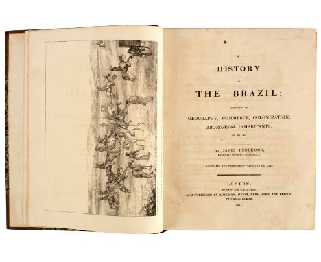
Henderson (James) A History of the Brazil, 1821. 4to., cont. half mottled calf. 2 maps, 28 lithographic plates/Provenance: Spetchley Park/see illustration CONDITION REPORT: Bindings a little scuffed here and there but pretty sound. Some foxing and light staining within. Small tear to margin of large map. Overall a decent copy.


Drake (Edward Cavendish) A New Universal Collection…Voyages and Travels, 1770. Folio, cont. calf. Engraved frontispiece, folding map and 8 single page maps, 54 plates/Provenance: Spetchley Park/see illustration CONDITION REPORT: 367:Binding rubbed. Head of spine chipped. Text, plates and maps generally clean.

An album containing a quantity of early 20th century onwards British and worldwide topographical postcards including a number from Australia, a tin containing further postcards, an album containing family portraits, a late 19th century Ordnance Survey map of Bristol and the mouth of the river Severn, various autographs including Kevin Keegan, etc (4)


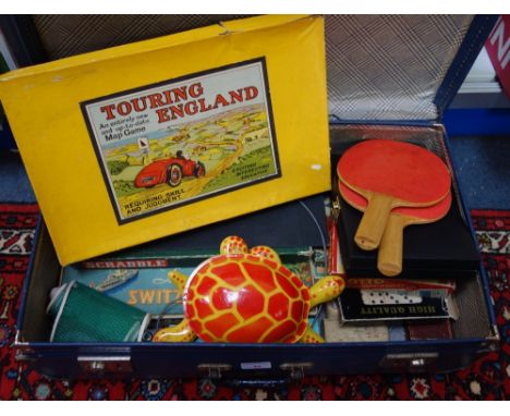
Air Cadets and Air Training ephemera, cloth patches, military badge and diary, dates 1940's with reference to Sunderland Cadets, includes Gliding and Flying log, 1948 personal diary of the cadet 'Left home for Pembroke Dock....', notebook, framed RAF Squadron patch, Sergeants stripes, chevron patches, Sunderland Squadron cloth patch and others, Meteorology, Principles of Flight, Mathematics, Safety etc notes, certificates, plotting series map, manuals, etc.


A COLLECTION OF TRANSPORT EPHEMERA containing postcards, photographs and maps of predominantly Railway and Shipping interest including two albums of photographs featuring events on the Lynton and Barnstable Railway between 1898-1935, a 'Railway Magazine' map of London from the early 1920's and an album of Warships and Merchant Vessels from the late 1800's to the present day


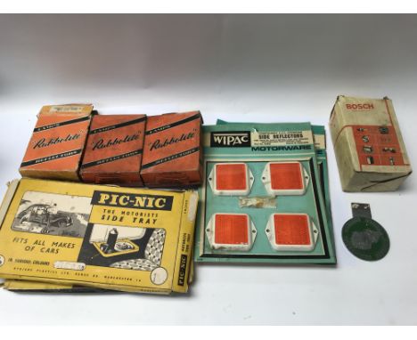
A collection of automobile interest items including accessories such as reflectors and a Bosch lamp, two vintage car door picnic trays, a High Performance Cortina Lotus workshop manual and brochure and an interesting "Automapic" Great Britain road map with sliding mechanism to expand the map, somewhat like an early sat nav design.


Gibson (Edmund), Chronicon Saxonicum ex MSS Codicibus & Lambard (William), Archaionomia..., the former with later cloth binding, previous owners' ink annotations on flyleaves, Sheldonian Theatre engraving to t.p. and double-page engraved map, pp. 7-8 of the Nominum Lorcorum & Virorum, Oxonii e Theatro Sheldoniano A. D. MDCXCII [1692]; the latter speckled tan calf, ex-libris G W F Gregor & S M Lee, 'Cantabrigiae, ex Officina Rogeri Daniel...MDCXLIIII [1644] (2)
-
109182 item(s)/page