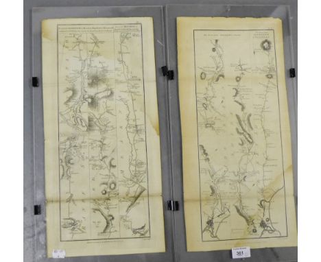
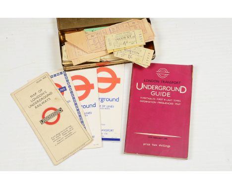
We found 109182 price guide item(s) matching your search

Refine your search

Year

Filter by Price Range
  • List
  • Grid
  • 109182 item(s)
    /page

Lot 485

London Transport Underground Maps and Tickets, four examples of the iconic map including a rare 1st edition (January 1933), F, some marks to front and tearing where folded, with 1969, 1973 and 1975 editions, a 1970 issue Underground Guide book together with a quantity of LT tickets, the majority pre-decimal currency (ie pre-1971), mostly G (4 maps, book + qty tickets in tin)

Lot 466

An early framed political map of Essex, 56 x 49cm.

Lot 392

An 18th Century hand-coloured etching, Dutch genre scene, in gilt frame, and a well reproduced map, in strip frame

Lot 405

A 19th Century hand-coloured map of the boundary changes in 1834 Great Marlow, High Wycombe and Buckingham, in strip frame, and two black and white engravings, genre scenes, in strip frames

Lot 406

Pierer van der Keere: a 17th Century coloured map of England, 3" x 5", and three small frames

Lot 164

AN ETCHED SILVER MAP OF GREAT BRITAIN, 54CM X 36CM, LONDON 1978, FRAMED

Lot 240A

The African Review - Map of Witwatersrand

Lot 575

CRAGGANMORE 12 YEAR OLDHighland Single Malt Scotch Whisky. 70cl, 40% volume. In carton.GLENKINCHIE 10 YEAR OLDLowland Single Malt Scotch Whisky. 70cl, 43% volume. In carton.TALISKER 10 YEAR OLDHighland Single Malt Scotch Whisky. Old style label with map. 70cl, 45.8% volume. In carton.3 bottles. CONDITION REPORT: All very good.

Lot 567

TALISKER FRIENDS OF THE CLASSIC MALTS 1989Highland Single Malt Scotch Whisky. Distilled 1989, bottled 1999. Bottle no. 2100. 70cl, 59.3% volume.TALISKER 10 YEAR OLDHighland Single Malt Scotch Whisky. Old style label with map. 70cl, 45.8% volume. In carton.2 bottles. CONDITION REPORT: Both very good.

Lot 832

A collection of 1st Gulf War Iraq souvenirs and trophies comprising items brought back by a member of The Royal Tank Regiment of the British Army including a printed Iraqi flag (62 x 100cm), a map of Operation Granby in green nylon map case, a tank logbook circa 1985, Iraqi officers' epaulettes and a Saddam Hussain propaganda picture

Lot 888

A military plotting board with attachments secured to rear including curves, map pins etc. marked Board Arty No3 Mk1 1951

Lot 1363

PICTURES AND PRINTS, to include Grand canyon paste, 3D map, countryside watercolour, etc

Lot 513

RAILWAY INTEREST PICTURES AND PRINTS, to include Lambert & Butler cigarette cards, Great Western Railway map, trains etc

Lot 338

A 1930s sheet map, no 99 of St Katherine Docks, copyright 1993 Chas E Goad Ltd, 63 x 53cm

Lot 1204

MIXED MAPS. Box of maps, mainly Michelin and Barts including Ordnance Survey linen map of North East Wales

Lot 208

Four antique unframed maps, including Jan Jansson (1588-1664) - Coloured engraving - 'Suffolk', 38cm x 50cm and a 19th Century coloured map of Pennsylvania Mostly in poor condition

Lot 205

Jan Jansson (1588-1664) - Coloured engraving - Map of Virginia and Florida, 34cm x 48cm, in Hogarth style frame and glazed Overall staining/sun damage, label verso for Benet Gallery, Cambridge

Lot 202

Johannes Blaeu - Coloured engraving - Westmoria Comitatus; Anglice Westmorland, c1648, later frame 39cm x 51cm, Robert Morden - Coloured engraving - Map of Cumberland, c1695, 40cm x 43.5cm & Westmoreland c1695 37cm x 42cm and a map of Westmoreland by Thomas Kitchen c1769 18cm x 23cm (4) Some fading and creases present, small tear to Bleau, otherwise good condition.

Lot 209

A late 18th Century coloured engraving - 'Tartaria', map of part of Russia and China, 38cm x 51cm (unframed) With small repair and slight foxing

Lot 203

Willem Blaeu (1571-1638) - Coloured engraving - Map of Palestine, 40cm x 50cm, published in Amsterdam, 1629, in double sided frame and glazed Good overall condition

Lot 206

18th Century French coloured engraving - 'Carte des Voyages des Sethos', map of Africa, 19cm x 27cm, in later gilt frame and glazed With creasing and staining

Lot 207

17th Century coloured engraving, thought to be after Gerardus Mercator (1512-1594) - Map of Ireland, 34cm x 47cm (unframed) Note: not the strongest impression, but good overall condition, thought to be from the Mercator-Hondius Atlas, French edition of 1633

Lot 552

Group of unframed and framed sporting prints together with a map of South Wales after Cary. (7)

Lot 264

After Gillray, a coloured Cupid, New Pantheon 4, engraving, together with an 18th century Morden map of Surrey, an engraving after Bartolozzi 'Market of Love', three other engravings

Lot 265

A 17th Century map of Devonshire after John Speed, a 19th Century map of Sussex after Moule and three reproduction maps.

Lot 69

JOHN SPEEDE SEVENTEENTH CENTURY HAND PAINTED COUNTY MAP 'Denbighshire' with plan of the town of Denbigh Dated 1610 15" x 20" (38.1 x 50.8cm)

Lot 267

EMANUEL BOWEN: 'Monmouthshire Divided into Hundreds', a hand coloured map, 13" x 9" and two similar smaller maps (3)

Lot 1210

RUSHWORTH (JOHN). "Historical Collections of Private Passages of State ... Beginning the Sixteenhth Year of King James, Anno 1618. And ending the Fifth Year of King Charls Anno 1629." 1st edn 2 engr ports and double page folding map, 18 prelims, 691 pp and 57 pp appendix all comp, cont, calf, recased, folio, Newcomb, 1659 good copy Condition report: Complete and in good condition

Lot 1239

CARY MAP. 5 sheet map of Cornwall, engr hand col, each sheet 21 x 26 inches some tears, pub G. & J. Cary, July 1, 1820 (comp set has 8 sheets)

Lot 1247

ENGRAVED MAP. "Herefordiae. Comitatus qui olim pars fuit Silurum delineatio." by Chr. Saxton, hand col engr map with cartouche, compass, coat of arms etc, 12.5 x 13.5 inches, f & g, c1640's good.

Lot 1293

ENGRAVED MAP. "The Road from Exeter to Truro in Cornwall." by em. Bowen, hand col, 7 1/4 x 4 3/4 inches, f & g, c1720 good

Lot 1294

ENGRAVED MAP. "Cornubia sive Cornwallia." by Jan Blaeu, hand col with cartouche, heraldry, shipping etc, 17 x 20 inches, f & g, c1645

Lot 1332

GILSON (CAPT. CHARLES). "The Race Round the World ... life of Mr. Wang." 1st edn, map & 6 col plts comp by Cyrus Cuneo, orig pict cl, 8vo 1914 g

Lot 1338

CRIMEAN WAR FOLDING POCKET MAP. "Wyld's Map of the Baltic or East Sea ... Embracing the Present Seat & War." fine hand col map with inset of Cronstadt & St Petersburg, linen-backed 20 x 28 inches, orig cl, d & t, James Wyld, March 1854

Lot 1377

SELOUS (FREDERICK COURTNEY). "A Hunter's Wanderings in Africa." 4th edn, folding map, plts & illus comp, orig cl gt, 8vo, Bently 1895 good

Lot 1378

WILLOUGHBY (CAPT. SIR JOHN C.). "East Africa & its Big Game." 1st edn, folding col map (paper repairs) & 18 plts comp, orig cl gt, 8vo 1889 good

Lot 1379

LYON (CAPT G.F.) " A Narrative of Travels in Northern Africa in the Years 1818, 19 & 20." 1st edn, title page, map & col plts supplied in facsimile mod leather binding showing routes taken, 4to, 1821

Lot 1384

DOLCOATH MINE LTD. col section of Main Lode 1917; other ephemera relating to the mine; Tehidy Minerals Ltd col surface map; other various ephemera

Lot 221

A WWII iron cross with pin back, a pocket watch a/f, and a part paper map of England and mainland Europe, circa 1940's

Lot 5

Robert Morden - A Map of Northumberland, engraving with hand-colouring, 42 x 35cms; 16 1/2 x 13 3/4in.

Lot 7

Thomas Kitchin - "A new improved Map of Northumberland divided into Wards", engraving with hand-colouring, printed for R. Sayer, 69 x 51cms; 27 x 20 1/4in.

Lot 6

**** Sudlow after **** Haywood - "A Map of Northumberland", engraving with hand-colouring, c.1789, 46 x 33cms; 18 x 13in., unframed.

Lot 122

BOWMORE 15YO - SESTANTE A great and rare Sestante bottling of Bowmore 15 Year Old single malt scotch whisky with a map label of Scotland. 75cl. 40% abv. Level low neck. Small tear and scuff to bottom of label. Otherwise very good condition. 1 bottle.

Lot 206

3 ISLE OF JURA A selection of Isle of Jura Single Malt Scotch Whiskies. ISLE OF JURA 10 YEAR OLD. 70cl. 40% abv. With old map label. In original carton. Level bottom neck/ top shoulder. Very good condition. ISLE OF JURA 10 YEAR OLD. 70cl. 40% abv. Old-style label & packaging. In original carton. Level bottom neck/ top shoulder. Excellent condition. 2 bottles. ISLE OF JURA SUPERSTITION. 70cl. 43% abv. The smoky version of the Jura Malt. In original carton. The ankh on the bottle is damaged. Good condition otherwise. 3 bottles.

Lot 294

*SMALL OBLONG TRAY WITH GLAZED NEEDLEWORK CENTRE, REPRODUCTION 'DOOMESDAY' MAP OF LANCASHIRE 1086, WATERCOLOUR DRAWING BY D. BUDGE 'FIGHTING DOGS OF ANCIENT BRITAIN' ETC......

Lot 613

AN OLD MAP of Oxfordshire 30cm x 40cm, a map of Hertfordshire, a 19th Century panoramic print and two further prints (5)

Lot 200

A MAP OF DEVONSHIRE divided into its hundreds by Eman Bowen, 52cm x 68cm, a 19th century map of Oxfordshire by T. Kitchin, 20cm x 17cm, a map of Somerset and a 19th century map of Oxfordshire (4)

Lot 172

A coloured map, Westmorland, Alfred Wainwright, signed by various Westmorland Dignataries

Lot 240

A selection of prints and pictures including Hanging game birds, Cumberland and Westmorland Map, Derbyshire map

Lot 357

Spencer and Co Map Reader Compass in glazed wooden case

Lot 269

Framed scale map 'The Fox Hunts of England, Wales & Scotland'

Lot 551

Emanuel Bowen (British, 1694-1767): A map of Lincolnshire, printed by 'Rob Sayers and John Bennett, no 53 Fleet St, et John Bowles, no 13 Cornhill and Barrington Bowles, No 69 St Paul's Church Yard', dated 1777, with title 'An Accurate Map of Lincoln Shire divided into Wapontakes', 51 by 41cm.

Lot 208

Large framed map depicting 'Map Of The West Riding County Of York' from an actual survey by C. & J. Greenwood

Lot 216

Large framed map depicting 'Map Of The North Riding County Of York' from an actual survey by C. & J. Greenwood

Lot 217

Large framed map depicting 'Map Of The East Riding County Of York' from an actual survey by C. Greenwood

Lot 138

Trow cartoon postcard, Royal Order of Buffaloes 1965 journal, Iniation booklet, Bartholomew's cloth map, OS map & assorted early 20th century family photographs some mounted as postcards and straw work box etc.

Lot 185

A companion pair of engravings depicting Ancient Alexandria, together with a framed map of the city (3)

Lot 339

Bacon's New Survey Map of South Scotland

Lot 357

Scarborough's Map of Scotland showing the Railroads and Steam Ship Lines with distances between stations and landings, in a glazed frame, 102 x 103cm

Lot 361

Two 18th century framed map panels to include the Road from Aberdeen to Fraserburgh and the road from Brechin to Aberdeen, Banf and Invernesshire etc. in clip frames (2), 55 x 28cm

Loading...Loading...
  • 109182 item(s)
    /page

Recently Viewed Lots