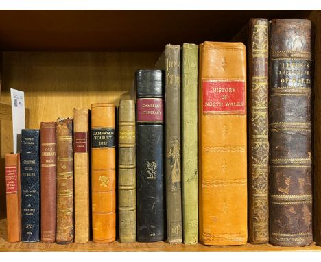
Gregson (Matthew). Portfolio ... of Fragments, relative to the history and antiquities of the county of Palatine and Duchy of Lancaster, 2nd edition, with additions, Liverpool: Printed by C. A. Worrall, 1824, lithograph portrait frontispiece, folding county map and plan, numerous engraved plates, woodcut illustrations and armorials to text, occasional light dust-soiling, modern half calf, folio, together with:Mortimer (William Williams), The History of the Hundred of Wirral, with a sketch of the city and county of Chester, compiled from the earliest authentic records, London: Whittaker & Co., 1847, half-title, folding lithograph map frontispiece, upper margin of title inscribed by the author, eight lithograph plates and folding table, some browning and light scattered spotting, endpapers renewed, original cloth-backed boards, recent gilt title to spine, 4to,Currie (William Wallace), Memoir of the life, writings, and correspondence of James Currie, M.D. F.R.S. of Liverpool, 2 volumes, London: Longman, Rees, Orme, Brown, and Green, 1831, engraved portrait frontispiece to first volume (spotted and offset to title), armorial bookplate of Edward Henry Roscoe to upper pastedowns, contemporary quarter straight-grain brown sheep, spine and extremities lightly rubbed, 8vo, plus other Liverpool related including, Gibson (T. Ellison), Crosby Records, Blundell's Diary of Nicholas Blundell, ESQ., from 1722 to 1728, Liverpool, 1895, Moore (Edward), Liverpool in King Charles the Second's time, 1899, Muir (Ramsay), Bygone Liverpool, 1913, Muir (Ramsay & Platt, Edith), A History of Municipal Government in Liverpool, 1906, Marillier (H.C.), The Liverpool School of Painters, 1904, and five Liverpool ephemeral items including a Theatre Royal broadside for Henry V, Saturday August 18, 1838, an issue of the Liverpool Mercury, August 30th, 1811, and a cancelled share certificate for the Liverpool Overhead Railway Company, September 28, 1897QTY: (14)


![Black's Road and Railway Travelling Map of England [and Wales], folding linen-backed coloured map, original cloth covers.The](https://cdn.globalauctionplatform.com/8a90754a-3776-402d-ba48-af9d00aed0fa/88522cb0-ff8e-43fc-bd1e-afdb00d2fe5b/468x382.jpg)


![* Gloucestershire. Saxton (C. & Hole G.), Glocestriae Comitatus olim sedes Dobunorum, [1610], hand-coloured engraved map,](https://cdn.globalauctionplatform.com/b3fbe50d-aae6-4645-8127-afcd00d44353/e3fd115e-b4b8-4b0b-a121-afcf00c98dc7/468x382.jpg)
![[Albrizzi, Giovanni Battista]. Forestiero illuminato intorno le cose piu' rare, e curiose antiche, e moderne, della citta di](https://cdn.globalauctionplatform.com/b3fbe50d-aae6-4645-8127-afcd00d44353/096845ff-c843-4e8a-bc2c-afcf00c8deb2/468x382.jpg)


![British Isles. Hole (G.), Britannia [1637], hand-coloured engraved map displayed in an oval cartouche with decorative margins](https://cdn.globalauctionplatform.com/b3fbe50d-aae6-4645-8127-afcd00d44353/9cf502b3-3966-4620-acb0-afcf00c9825b/468x382.jpg)


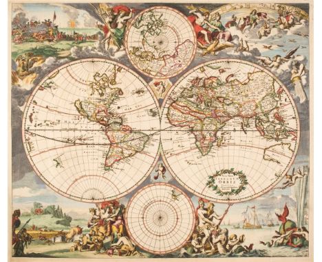
![World. Ortelius (Abraham), Typus Orbis Terrarum, 1587 but [1592 - 1612], hand-coloured engraved map, ornate strapwork border](https://cdn.globalauctionplatform.com/b3fbe50d-aae6-4645-8127-afcd00d44353/fd64e1fa-5a88-4a6c-aa5f-afcf00c9a342/468x382.jpg)
![China. Speed (John), The Kingdome of China newly augmented, Roger Rea [1662], hand-coloured 'carte-a-figure' map, with eight](https://cdn.globalauctionplatform.com/b3fbe50d-aae6-4645-8127-afcd00d44353/974f6f78-5fe0-499b-a842-afcf00c98899/468x382.jpg)
![East Indies. Ortelius (Abraham), Indiae Orientalis Insularumque Adiacientium Typus, Antwerp [1595 or later], hand-coloured en](https://cdn.globalauctionplatform.com/b3fbe50d-aae6-4645-8127-afcd00d44353/008c3a77-5932-4200-8d67-afcf00c98965/468x382.jpg)