We found 109198 price guide item(s) matching your search
There are 109198 lots that match your search criteria. Subscribe now to get instant access to the full price guide service.
Click here to subscribe- List
- Grid
-
109198 item(s)/page


Lot 235
Map Reference. A collection of approximately 75 volumes, 20th century, map reference and facsimile atlases, including examples by Manasek, Lister, Swift, Blake, Potter and Baynton-Williams, including Wallis (Helen, editor). The Maps and Text of the Boke of Idrography presented by Jean Rotz to Henry VIII, facsimile edition, published Oxford for Presentation to the Members of the Roxburghe Club, 1981, numerous colour plates, publisher's half morocco gilt, slight wear to extremities, large folio, together with two cartons of map related periodicals including broken runs of The Map Collector, The Imcos Journal, Imago Mundi and Mercators World, various sizes and conditionQty: (approx. 75 and 2 cartons)

Lot 237
* Maps. A mixed collection of eight maps, 17th - 19th century, including Saxton (Christopher & Kip William). Sussexia sive Southsex olim pars Regnorum, [1637], hand coloured engraved map, strapwork cartouche and mileage scale, trimmed to the image along vertical margins, 225 x 385 mm, mounted, framed and glazed. together with Saxton (Christopher & Hole G.). Frugiferi ac ameni Herefordiae comitatus qui olim pars suit Silurum delineatio, [1637], hand coloured engraved map, strapwork cartouche and mileage scale, 290 x 310 mm, mounted, framed and glazed, with Morden (Robert). Essex [1695 or later], hand coloured engraved map, slight offsetting, 345 x 420 mm, mounted, framed and glazed, plus Van den Keere (Pieter). Midle-sex [and] Wight island, [1627 or later], two hand coloured engraved maps, each approximately 80 x 120 mm, mounted, framed and glazed, and Moule (Thomas). Buckinghamshire [and] Berkshire, circa 1848, two hand coloured engraved maps, each approximately 260 x 195 mm, mounted, framed and glazed, with Rocque (John). Herefordshire, circa 1753, uncoloured engraved map, 160 x 205 mm, mounted, framed and glazed, together with three map reference books, comprising of Yasha Beresiner's 'British County Maps Reference and Price Guide, Nigel Nicholson's The Counties of Britain A Tudor Atlas by John Speed and a facsimile atlas of Christopher Saxton's 16th-century maps with an introduction by William Ravenhill, various sizes, condition G/VGQty: (11)
Lot 240
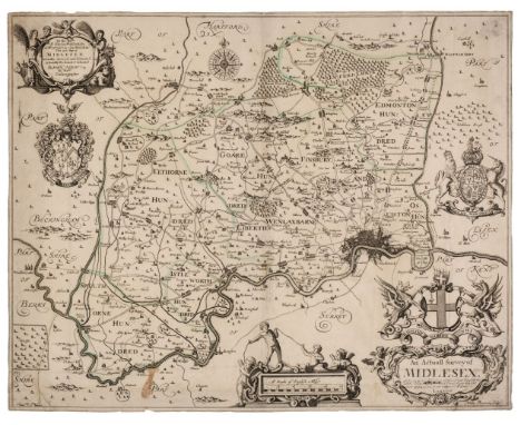
Middlesex. Ogilby (John), An Actuall Survey of Midlesex, George Willdey, circa 1732, engraved map by Walter Binnerman with sparse outline colouring, large title cartouche and dedication, compass rose and two armorial coats of arms, trimmed to neatline, slight staining, old folds with some strengthening on verso, small abraided hole in mileage scale, slight marginal fraying, slight adhesion scaring to verso, 415 x 525 mm, together with Norden (John, after). Middlesex olima Trinoban Tibus habitata, [1637], uncoloured engraved map, large strapwork cartouche and table of explanation, some staining to central fold, 270 x 335 mmQty: (2)

Lot 241
Middlesex. Smith (Joseph), The County of Middlesex Actually Survey'd and Delineated and Newly Corrected & Amended with many Additions..., 1714, large map with contemporary outline colouring engraved by John Oliver, trimmed to neatline, small repaired closed tears affecting image, old folds partially strengthened on verso, slight staining, 585 x 905 mmQty: (1)NOTESA scarce map engraved for a never-completed atlas. Only six counties were ever finished:- Middlesex, Surrey, Hertfordshire, Kent, Buckinghamshire and Oxfordshire, the project presumably failing due to financial problems.
Lot 246
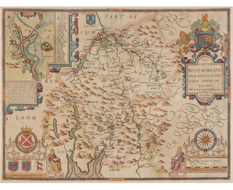
Northern Counties. Speed (John), The Countie of Westmorland and Kendale the cheif towne described, Henry Overton, circa 1743, hand coloured engraved map, an inset town plan of Kendal, large strapwork cartouche, mileage scale and compass rose, trimmed to neatline with margins extended, 380 x 505 mm, no text on verso, together with The Bishoprick and Citie of Durham, 1st edition, [1611], uncoloured engraved map, an inset town plan of Durham, torn with very slight loss to strapwork margin at the lower right corner, long repaired closed tear affecting image, slight thinning to paper but with no loss, 380 x 505 mm, English text on verso, with The North and East Ridins of Yorkshire, published John Sudbury & George Humble, circa 1627, hand coloured engraved map, inset town plans of Richmond and Hull, some marginal fraying with slight loss to strapwork margin, slight staining, slight abrasion to the printed surface, small margins, 390 x 515 mm, English text on versoQty: (3)
Lot 247
Northern Europe. Lange (Johann Elias), Neue Karte den gegenwartigen Kriegs-Schauplatze zwischen den Russisch. Kayserl: und Königl: Schwedischen Armeen und Flotten,welche vorzu?gl. ganz Finland, Liefland, Estland, Ingermanland, ein Theil von Pohlen und Rusland, Ost- und West-Preussen,die Ost See, Dännemark, Schweden, Norwegen, und ein Theil von Deutschland, nebst denen bisherigen Stellungen gedachter Armeen enthält, Leipzig,1788, engraved map with contemporary outline colouring, three inset maps of the eastern Gulf of Finland, Savonlinna (Plan von Nyslot) and Vyborg (Wyborg), inset text describing the Russo-Swedish war (1788 - 1790), slight overall toning, very slight creasing, 415 x 480 mmQty: (1)NOTESA rare historical-military map published during the Russo-Swedish War (1788 - 1790) giving detailed information concerning the war.

Lot 249
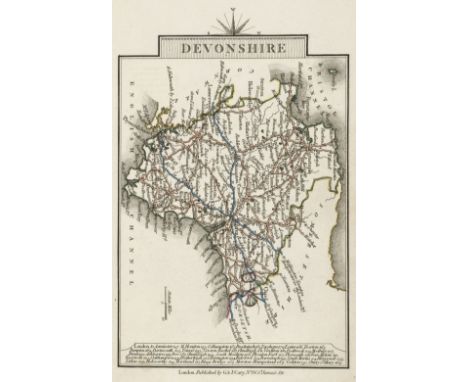
* Ogilby (John). The Continuation of the Road from London to the Lands End, Plate 2d, commencing at Andover com. Hants & extending to Crookhorn com. Somerset..., circa 1675, uncoloured engraved strip road map, 325 x 445 mm, framed and glazedQty: (1)NOTESThe road commences at Andover and runs through Winchester, Salisbury, Shaftesbury, Sherborne and Yeovil and ends at Crewkerne. Sheet number 26.
![Ogilby (John). The Road from Bristol co. Glouc. to Banbury com Oxo. [1675 or later], uncoloured engraved strip road map, slig](https://cdn.globalauctionplatform.com/27556d06-14f1-4e11-85a7-ac1e00d5ce41/b7db74a1-f430-4eb0-9653-ac1e010549ed/468x382.jpg)
Lot 250
Ogilby (John). The Road from Bristol co. Glouc. to Banbury com Oxo. [1675 or later], uncoloured engraved strip road map, slight mount staining, 335 x 445 mm, supplied with the contemporary sheet of descriptive textQty: (2)NOTESThe road commences at Bristol and runs through Chipping Sodbury, Tetbury, Cirencester, Bibury, Burford, Shipton-under-Wychwood and Bloxham and ends at Banbury. Sheet number 55.
![* Ogilby (John). The Road from London to Barstable in Devonshire, [1676 or later], hand coloured engraved strip road map, 'fo](https://cdn.globalauctionplatform.com/27556d06-14f1-4e11-85a7-ac1e00d5ce41/29c4b65f-bcf7-42ce-a476-ac1e01054a95/468x382.jpg)
Lot 251
* Ogilby (John). The Road from London to Barstable in Devonshire, [1676 or later], hand coloured engraved strip road map, 'fox-hunting cartouche', 365 x 445 mm, framed and glazed, together with a hand coloured engraved smaller version of the same map by John Senex with another road map (The Continuation of the Road from London to Barnstable in Devonshire) printed on the verso, 165 x 210 mm, mounted framed and double glazed, with Owen (John & Bowen Emanuel). Untitled road map, [1720 or later], hand-coloured engraved strip road map running from Chippenham to Wells and on the verso from Marlborough to Wells, 185 x 120 mm, mounted, framed and double glazed, below the map inset into the mount is a brass 'Bath Token', dated 1811 and decorated with 'the golden fleece' of a lamb hanging from a ribbon and on the verso the legend ' A pound note for every 240 tokens given by S. T. Whitchurch and W. Dore', 35 mm in diameterQty: (3)NOTESThe first described item is Sheet 32. The road commences at Andover and runs through Market Lavington, Warminster and Bruton and ends at Bridgewater

![Ogilby (John). The Road from London to St Davids in com Pembroke, [1676 or later], hand coloured engraved strip road map, lai](https://cdn.globalauctionplatform.com/27556d06-14f1-4e11-85a7-ac1e00d5ce41/59ae5495-32c2-43a1-acac-ac1e01054bd4/468x382.jpg)
Lot 253
Ogilby (John). The Road from London to St Davids in com Pembroke, [1676 or later], hand coloured engraved strip road map, laid on card, toned overall,300 x 450 mmQty: (1)NOTESThe road commences in London and passes through Brentford, Hounslow, Stowe, Maidenhead, Henley, Nettlebed and Dorchester and ends at Abingdon. Sheet number 14.

Lot 255
Ogilby (John). The Road from Oxford to Cambridge, circa 1675, hand coloured engraved strip road map, decorative cartouche showing a surveyor using a waywiser, one small repaired hole affecting image, laid on later paper, 340 x 420 mmQty: (1)NOTESThe road commences at Oxford and runs through Bicester, Buckingham, Newport Pagball, Bedford and Gamlingay and ends at Cambridge.

Lot 259
* Oxfordshire. Blaeu (Johannes), Oxonium comitatus vulgo Oxford Shire, circa 1645, engraved map with bright contemporary hand colouring, large decorative cartouche and mileage scale and the vertical margins decorated with sixteen heraldic shields of Oxford colleges, 380 x 500 mm, French text and a hand coloured engraved view of the Rollright Stones on the verso, framed and double glazed, together with Blome (Richard). A Generall Mapp of the County of Oxford with its Hundreds, [1673], hand coloured engraved map, one wormhole affecting image, 335 x 295 mm, framed and glazedQty: (1)NOTESA clean example in very good condition.

Lot 260
Oxfordshire. Blaeu (Johannes), Oxonium Comitatus vulgo Oxford Shire, Amsterdam, circa 1648, engraved map with contemporary hand colouring, heightened in gold, some overall toning, several wormholes repaired on verso, central fold strengthened on verso, the whole backed with archival tissue, 380 x 505 mm, Latin text on verso, together with Jansson (Jan). Oxonium Comitatus vulgo Oxfordshire, Amsterdam, circa 1655, engraved map with contemporary hand colouring, slight overall toning, margins stained but not affecting image, 380 x 485 mm, no text on verso, with Morden (Robert). Oxford Shire, [1695 or later], uncoloured engraved map, slight creasing and spotting, some fraying to margins, 420 x 360 mm with three other uncoloured engraved maps of Oxfordshire by Skelton, Cary and Harrison, various sizes and conditionQty: (6)

Lot 261
Oxfordshire. Speed (John), Oxfordshire described with ye Citie and the Armes of the Colledges of ye famous University, Thomas Bassett & Richard Chiswell [1676], u ncoloured engraved map, inset town plan of Oxford, the vertical margins decorated with 18 heraldic shields,390 x 525 mm, English text on verso, together with Saxton (Christopher & Hole G.), Oxoniensis comitatus vulgo Oxfordshyre qui pars olim Dubunorum, [1610], uncoloured engraved map, large strapwork cartouche, 275 x 290 mm, with Skelton (J., publisher). A Map of Oxfordshire to accompany Skelton's Engraved Illustrations of the Antiquities in the County, Oxford, 1827, uncoloured engraved map on India wove, slight spotting to margins, 300 x 225 mm, with another copy similarQty: (4)

Lot 262
Oxfordshire. Speed (John), Oxfordshire described with ye Citie and the Amres of the Colledges of yt famous University, John Sudbury & George Humble, circa 1627, hand coloured engraved map, an inset town plan of Oxford, the vertical margins decorated with eighteen heraldic shields, central fold strengthened on verso, 390 x 520 mm, English text on verso, mountedQty: (1)

Lot 263
Pembroke. Saxton (Christopher), Penbrok Comitat qui inter Meridionales Cambriae ... Ano. Dni. 1578, circa 1579, hand coloured engraved map, large strapwork cartouche surmounted by the royal coat of arms with a separate heraldic shield of Thomas Seckford, good margins, slight overall toning, 355 x 465 mmQty: (1)

Lot 266
* Poland. Blaeu ( Willem Janszoon), Polonia Regnum et Silesia Ducatus, circa 1635, engraved map with contemporary outline colouring, decorative cartouche and mileage scale, slight overall toning, with another uncoloured example with slight toning to central fold, each 415 x 510 mm, double aperture mount, framed and glazedQty: (1)

Lot 267
Poland. Blaeu (Johannes), Palatinatus Posnaniensis, in Maiori Polonia Primarii nova delineatio. per G. F. M. Amsterdam, circa 1670, engraved map with contemporary hand colouring, large floriate cartouche and mileage scale, 420 x 530 mm, Spanish text on verso, together with Ducatus Silesiae Giogani vera delineatio, Amsterdam circa 1640, engraved map with contemporary outline colouring, decorative strapwork cartouche and table of explanation, 425 x 510 mm, Latin text on versoQty: (2)

Lot 268
Poland. Danckerts (Justus), Regni Poloniae et Ducatus Lithuaniae, Voliniae, Podoliae, Ucraniae, Prussiae et Curlandiae..., Amsterdam circa 1700, engraved map with contemporary outline colouring, with additional contemporary underlining of regions and towns, some marginal worming but not affecting image, small margins, 505 x 585 mm, together with Homann (Johann Baptist). Regni Poloniae Magnique ducatus Lithuaniae nova et exacta tabula..., Nuremberg, 1739, engraved map with contemporary hand colouring 485 x 545 mm, with De L'Isle (Guillaume). La Pologne dres ée sur ce qu'en ont donn é Starovolsk , Beauplan , Hartnoch et autres autour ..., Paris, 1796, engraved map with contemporary outline colouring and some later enhancement to the cartouche, 485 x 625 mmQty: (3)

Lot 269
Poland. De L'Isle (Guillaume), La Pologne Dressée sur ce qu'en ont donné Starovolsk, Beauplan, Hartnoch et autres Auteurs..., J. Covens & C. Mortier, Amsterdam, circa 1730, engraved map with contemporary outline colouring, large uncoloured engraved cartouche and mileage scale, narrow margin at base, 495 x 620 mm, together with Thomson (John). Poland, circa 1820, engraved map with contemporary hand colouring and some later enhancement, 510 x 605 mmQty: (2)

Lot 27
Ashmole (Elias). The Antiquities of Berkshire, 3 volumes, London: E, Curll, 1719, folding engraved frontispiece to volume 1, folding engraved map 'Ye South Side of Windsor Castle' (published by John Overton, close trimmed to left, right & lower decorative borders, sheet size 37.8 x 50 cm), volume 3 also with additional folding engraved county map by John Speed 'Barkshire Described ... sold by Henry Overton, [1743]' with hand-colouring in outline (close trimmed to left, right & lower decorative borders, blank verso, sheet size 39.6 x 51 cm), 11 folding pedigrees, volume 1 with some worm holes to lower blank margins throughout majority of volume, some browning and scattered spotting, contemporary calf gilt, maroon morocco title label to spines, light wear to extremities, 8voQty: (3)

Lot 270
Poland. Mercator (Gerard & Hondius H.), Polonia, circa 1640, hand coloured engraved map, strapwork cartouche, central fold strengthened on verso, repaired wormholes in margin but not affecting image,340 x 455 mm, French text on versoQty: (1)NOTESThe map depicts most of present-day Poland and a portion of the Czech Republic. Clearly shown are cities, towns, villages, rivers, and mountains. Among the major cities to appear are Warsaw ( Warzonia ), Krakow ( Craconia , and Wroclaw ( Breslaw ). Silesia is clearly outlined and labelled. Mercator's name has been erased and a new title cartouche was added for this edition.

Lot 271
Poland. Visscher (Nicholas), Haec Tabula nova Poloniae et Silesiae, Amsterdam, 1630, hand-coloured 'carte des figures' map engraved by A. Goos, with 2 oval panoramas of Krakow and Danzig (Gdansk) along the upper margin, 8 costumed figures to the vertical margins, portraits of Kings in each corner and a further 4 oval vignettes of principal cities to the lower horizontal margins, trimmed to neat line and laid on later paper, old folds, 465 x 530 mmQty: (1)NOTESSchilder, Monumenta VI, 98.

Lot 272
* Poland. Von Reilly (Franz Johann Joseph), Karte von dem Konigreiche Preussen ..., Vienna, circa 1796, map engraved by Anton Benedieti with contemporary hand colouring, decorative cartouche, mileage scales and table of explanation, slight creasing, additional vertical central fold, 600 x 745 mm, mounted, framed and glazedQty: (1)
Lot 273
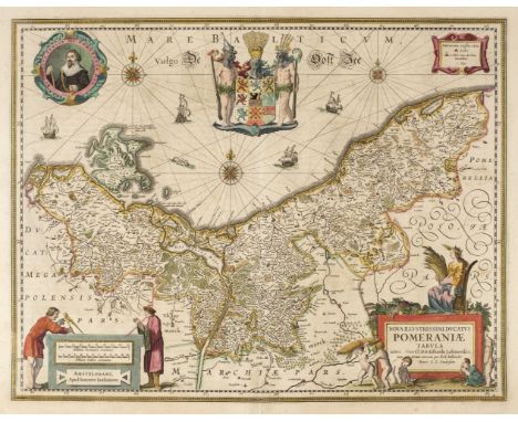
Poland/Pomerania. Jansson (Jan), Nova Illustrissimi ducta Pomeraniae tabula, Amsterdam, circa 1630, engraved map with contemporary outline colouring, large decorative cartouche and mileage scale, compass rose and numerous rhumb lies, occasional marginal repaired closed tears but not affecting image, 385 x 495 mm, French text on verso, together with Dankerts (Theodore). Ductas Pomeraniae Tabula Generalis in qua sunt Ducatus Pomeraniae, Stettinensi, Cassubiae, Vandaliae et Bardensis..., Amsterdam, circa 1690, engraved map with contemporary outline colouring, large decorative cartouche, some marginal finger and dust soiling, 500 x 580 mm, with De Wit (Frederick). Marchionatus Brandenburgi et Ducatus Pomeraniae tabula..., Amsterdam, circa 1680, engraved map with contemporary outline colouring, very slight staining, 490 x 565 mm, plus Rossi (Giacomo Giovanni), La Pomerania divisa in Citerioe ò Reale..., Rome 1689, hand coloured engraved map, large decorative cartouche, 435 x 555 mmQty: (4)

Lot 276
* Poland/Silesia. Homann (Johann Baptist, heirs of), Pricipatus Silesiae Wratislaviensis..., Nuremberg, circa 1750, two engraved maps with contemporary outline colouring and some later enhancement to one cartouche (the other cartouche being uncoloured), slight overall toning to the lower map, upper map trimmed along upper margin with slight loss to the printed surface, skillfully replaced in facsimile, each 555 x 820 mm, double aperture mount, framed and glazed, together with Principatus Silesiae Iavoriensis..., Nuremberg, circa 1750, two engraved maps with contemporary outline colouring and some later enhancement to one cartouche (the other being uncoloured), occasional marginal closed repaired tears, upper map with printer's fold, each approximately 555 x 820 mm, presented in a double aperture mount, framed and glazedQty: (2)NOTESOriginally published in 'The Atlas Silesiae'.

Lot 277
* Poland/Silesia. Homann (Johann Baptist, heirs of), Principatus Silesiae Bregensis..., Nuremberg, circa 1750, two engraved maps with contemporary outline colouring and some later enhancement to one cartouche (the other cartouche being uncoloured), one map with short split at base of central fold, each 560 x 830 mm, presented in a double aperture mount, framed and glazed, together with Principatus Silesiae Wolani..., Nuremberg, circa 1750, two engraved maps with contemporary outline colouring and some later enhancement to one cartouche (the other being uncoloured), occasional marginal closed repaired tears, slight soiling to one map, each approximately 560 x 825 mm, presented in a double aperture mount, framed and glazedQty: (2)

Lot 280
Pomerania . Le Rouge (George Louis), Duché de Pomeranie contenant les Duchées de Stettin, de Wolgats, de Bardt, de Cassubie, de Vandalie, la Principauté et Isle de Rugen, le Comté de Gutzkow, le Seigneuries de Louwenbroch et de Butow, Paris, 1757, engraved map with contemporary outline colouring, large uncoloured cartouche, two small printer's folds, 505 x 690 mm, together with De Vaugondy (Robert). Partie Septentrionale du Cercle de Haute Saxe qui contient le Duché de Poméranie et le Marquisat de Brandebourg [and] Partie Meridionale du Cercle de Haute saxe où sont le Duché de Saxe..., Paris, 1751 - 1756, two engraved maps with contemporary outline colouring, each with a large uncoloured strapwork cartouche,. the first described map with an inset map of the environs of the Marquisat of Brandenbourg, slight marginal dust soiling and staining but not affecting printed surface, each approximately 490 x 555 mmQty: (3)


Lot 287
Sea charts. Collins (Captain Greenville), Untitled chart of the East coast of England, circa 1700, large uncoloured engraved chart, running from Dover to the River Humber, large inset map of the River Thames and London, dedication and mileage scale placed on the sails of a large inset vignette of a man-of-war, old folds, toned overall, small repaired closed tear, 600 x 940 mm, together with The River Avon from the Severn to the Citty of Bristoll, circa 1700, uncoloured engraved chart, large decorative cartouche, old folds, some spotting, staining and dust soiling, slight marginal fraying, 405 x 930 mmQty: (2)

Lot 288
Sea of Azof. Visscher (Nicolas), Nouvelle Carte Geographique de la Mer d'Asof ou de Zabache & des Palus Meotides, Amsterdam, circa 1700, engraved map of the Northern Black Sea, Ukraine and the Crimea, bright contemporary hand colouring, 485 x 580 mmQty: (1)NOTESA scarce map which was only published in a few composite atlases. There is a later edition of about 1740 with a Henry De Leth publication line.
Lot 290
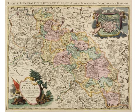
Silesia/Poland. Covens J. & Mortier P. (publishers), Sup.s et Inferioris Ducatus Silesiae in suos XVII Minores..., Amsterdam, 1741, engraved map with contemporary outline colouring, inset town plan of Breslau, large decorative cartouche, title repeated above map in French, 505 x 580 mm, together with Jansson (Jan). Silesiae Ducatus Accurata et vera delineatio..., Amsterdam, circa 1660, engraved map with contemporary hand colouring, but somewhat faded, some staining, 390 x 495 mm, Latin text on verso, with Schenk (P.). Mappa Geographica Exactissima Cointinens Imperatoris Haereditarium DominiumSilesiam nec non eiusdem Provincias interiores Comitatus..., Amsterdam, circa 1705, engraved map with contemporary outline colouring, some staining, 495 x 580 mm, with Blaeu (Johannes). Baronatus Carolato Bethaniensis in Silesia Inferiore..., Amsterdam, [1662], uncoloured engraved map, 415 x 510 mm, Spanish text on verso, plus Schenk (Peter). Ducatus Silesiae Wolanus, Amsterdam, circa 1690, engraved map with contemporary outline colouring, strapwork cartouche and mileage scale, short split at base of central fold, 410 x 385 mm and Walch (Johannes). Charte von Schlesien Maehren und der Lausitz..., Augsburg, 1805, engraved map of the whole of Silesia with contemporary outline colouring, later manuscript title to verso, 500 x 560 mmQty: (6)

Lot 291
* Somerset. Blaeu (Johannes), Somersettensis Comitatus. Somerset-Shire, Amsterdam, circa 1645, engraved map with contemporary outline colouring, decorative cartouche and mileage scale, very slight spotting and creasing, very slight toning to central fold, framed and double-glazed, 385 x 505 mm, Latin text on verso, together with Blome (Richard). A Mapp of the County of Somerset with its Hundreds, [1673], hand coloured engraved map, 200 x 250 mm, mounted, framed and glazedQty: (2)

Lot 292
Somerset. Speed (John), Somerset -Shire described and in to Hundreds devided with the plott of the famous and most wholsom waters and citie of the Bathe, John Sudbury & George Humble, circa 1627, hand coloured engraved map, inset town plan of Bath, slight overall toning, 380 x 505 mm, English text on verso, together with Saxton (Christopher & Kip William). Somersettensis Comitatus vulgo Somerett Shyre qui olim pars suit Belgarum, [1637], hand coloured engraved map, large strapwork cartouche and mileage scale, abrasion causing slight loss to printed surface and paper, slight overall toning, 280 x 385 mm, with another copy similar trimmed to the neatline on vertical marginsQty: (3)


Lot 294
* Staffordshire. Speed (John), Stafford Countie and Towne with the ancient Citie Lichfeild described..., John Sudbury & George Humble, circa 1627, hand coloured engraved map, inset town plans of Lichfield and Stafford, some creasing, central fold with some abrasion and closed tears, repaired on verso, some marginal fraying with slight loss to lower right corner, one small rust hole, 385 x 510 mm, mounted, framed and double-glazed, English text on verso,Qty: (1)

Lot 295
Surrey. Blome (Richard), A Mapp of Surrey with its Hundreds, circa 1673, hand coloured engraved map, 260 x 310 mm, mounted, together with Cumberland. Dix (Thomas), A New Map of the County of Cumberland, Divided into Wards, published W. Darton, July 6th 1816, engraved map with contemporary hand colouring, circular cartouche and an uncoloured vignette of the Bowder Stone, 455 x 355 mm, mountedQty: (2)
![Surrey. Speed (John), Surrey Described and Divided into Hundreds, John Sudbury & George Humble, [1616], engraved map with](https://cdn.globalauctionplatform.com/27556d06-14f1-4e11-85a7-ac1e00d5ce41/039c7192-f8db-40b1-8ddb-ac1e01056922/468x382.jpg)
Lot 296
Surrey. Speed (John), Surrey Described and Divided into Hundreds, John Sudbury & George Humble, [1616], engraved map with early hand colouring, inset views of Richmond and Nonsuch palaces, one repaired marginal closed tear but not affecting printed image, good margins, central fold strengthened on verso, 385 x 520 mm, Latin text on versoQty: (1)NOTESA very good clean and dark impression.
Lot 297
* Wales. Blome (Richard), A Generall Mapp of South Wales wherein are the Countyes of Glamorgan, Carmardan, Pembrok, Cardigan, Brecknock, Radnor, [1673], hand coloured engraved map, decorated with six heraldic coats of arms, decorative cartouche, old folds, slight staining, 345 x 455 mm, mounted, framed and glazed, together with Saxton (Christopher & Hole G.). Glamorgan comitatus qui olim pars Silurum, [1637], hand coloured engraved map, large strapwork cartouche, mileage scale and compass rose, 275 x 340 mm, mounted, framed and glazed, with Rocque (John). Radnor Shire, [1753], hand coloured engraved map, inset map of the Northumberland coast and Holy Island, 200 x 160 mm, mounted, framed and glazedQty: (3)

Lot 298
Warburton (John & Overton P.). The Counties of Essex, Middlesex & Hertfordshire actualy Survey'd by Several hands Corrected and Amended & Humbly Dedicates to the Nobility and Gentry of the said Counties, Philip Overton and Thos. Bowles, 1726, large engraved map on two sheets (not conjoined) with bright contemporary hand colouring, inset plan of St. Albans and a prospect of Colchester, each sheet 610 x 475 mmQty: (1)NOTESThis map was originally published in 1720 by John Warburton, Joseph Bland and Payler Smith and was decorated with over 700 armorial crests. These were the arms of the resident gentry, nobility and landowners who had subscribed and paid for the survey and publication of the map. This slightly later and arguably plagiarised example had no need of sponsors so Overton and Bowles dispensed with the armorials but added the town plan and the prospect. .

Lot 299
* Warsaw. Tardieu (Pierre), Varsovie, circa 1790, hand coloured engraved city plan orientated to the south-west, key below map identifying 64 locations, 335 x 435 mm, displayed in a double aperture mount with another uncoloured example which is sectionalised and laid on linen, framed and glazedQty: (1)
Lot 30
Brannon (George). Vectis Scenery: being a series of original and select views, exhibiting the picturesque beauties, local peculiarities, and places of particular interest in the Isle of Wight, Wotton Common, Isle of Wight: Printed and published by the engraver, 1829, hand-coloured engraved map and 48 engraved plates, tissue guards, scattered spotting, some toning & light offsetting mostly to text leaves, armorial bookplate of Viscount Gort to upper pastedown, contemporary red half sheep, title label to upper board, rubbed, extremities worn, oblong 4to, together with: Roscoe (Thomas) , Summer Tour in the Isle of Wight; including Portsmouth, Southampton, Winchester, the South Western Railway, &c., London: J. & F. Harwood, 1843, half-title with contemporary inscription, engraved title, 34 engraved plates (including frontispiece), folding engraved map at rear, numerous engraved vignette illustrations, some spotting and toning, signature to front pastedown, all edges gilt, original gilt & blind decorated cloth, joints split at head & foot, 8vo, Barber (Thomas) , Barber's Picturesque Illustrations of the Isle of Wight ... accompanied by Historical and Topographical Descriptions, London: Simpkin & Marshall, [1834], engraved title, 40 engraved plates, tissue guards, double-page engraved map at rear, scattered spotting, contemporary ownership inscription to front pastedown, original cloth, some fading, joints and extremities frayed, 8vo, and other Isle of Wight, Hampshire & WInchester related etc., including An Historical Account of Winchester, with Descriptive Walks, by Charles Ball, Winchester: James Robbins, 1818; The History and Antiquities of the See and Cathedral Church of Winchester, by John Britton, 1836; Picturesque Memorials of Winchester, [by Peter Hall], Winchester, 1830; Picturesque Memorials of Salisbury, by Peter Hall, Salisbury, 1834; Brannon's Picture of the Isle of Wight, [1847]; The New Forest and the Isle of Wight, by C.J. Cornish, 1895; and The History and Survey of the Antiquities of Winchester, by John Milner, 2 volumes, 3rd edition, Winchester, [1839], etc.Qty: (21)

Lot 300
Warwickshire. Speed (John), The Counti of Warwick The Shire Towne and Citie of Coventre described, John Sudbury & George Humble, circa 1627, hand coloured engraved map, inset town plans of Warwick and Coventry, central fold strengthened on verso, narrow margins, 375 x 505 mm, English text on versoQty: (1)
Lot 301
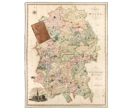
Wiltshire. Greenwood (C.), Map of the County of Wilts, from actual survey in the years 1819 & 1820, published Dec.12th, 1820, engraved map with bright contemporary hand colouring, sectionalised and laid on linen, calligraphic title, dedication, compass rose, table of explanation and an uncoloured vignette of Salisbury Cathedral, edged in green silk, 1440 x 1115 mm, marbled endpapers, contained in a contemporary calf book box with contrasting morocco label to spine, worn and rubbedQty: (1)NOTESA bright and clean copy.

Lot 302
World. Speed (John), A New and Accurate Map of the World, drawne according to ye truest descriptions latest Discoveries & best Observations yt have beene made by English or Stranders, 1626, George Humble, [1627], hand coloured engraved map of the world on a hemispheral projection, two additional celestial projections, insular California, decorated with vignettes of the four elements and portraits of explorers, severe marginal fraying with loss to printed image at base and replaced in facsimile, closed tear affecting image, some dust soiling, creasing and cracking to the printed image causing slight loss, central fold repaired and strengthened on verso, 395 x 520 mm, English text on versoQty: (1)NOTESRodney W. Shirley, The Mapping of the World: Early Printed World Maps, 1472-1700, 317.
Lot 303
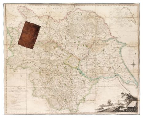
Yorkshire. Tuke (John), Map of the County of York republished with additions & corrections, 4th edition, 1816, large scale engraved map with contemporary outline colouring, sectionalised and laid on linen, large uncoloured cartouche which includes a distant view of York Minster, inset map of Yorkshire, table of explanation, compass rose and table of heights of the principal hills, some staining, edged in green silk, 1200 x 1420 mm, marbled endpapers, contained in a contemporary calf book box some wear and crude sellotape repairs to boxQty: (1)NOTESProvenance: The Estate of the late David Wilson (1926-2020).
![Campbell (E.C.). Scottish Scenery. Sketches from Nature, [Edinburgh, circa 1835], 50 lithograph plates including hand-coloure](https://cdn.globalauctionplatform.com/27556d06-14f1-4e11-85a7-ac1e00d5ce41/de165b7e-47ee-4589-8f58-ac1e0104ce58/468x382.jpg)
Lot 34
Campbell (E.C.). Scottish Scenery. Sketches from Nature, [Edinburgh, circa 1835], 50 lithograph plates including hand-coloured map, tipped-in additional subscribers list present and publisher's advertisement slip tipped-in at rear, few faint blind stamps to lower outer corners, some browning & spotting mostly at head, bookplate of Archibald Walker to upper pastedown, hinges split, original green cloth, printed paper label to upper board (Scottish Scenery ... by Mrs Robert Campbell), spine ends worn and light fraying to extremities, oblong 4to, together with: Banks & Co. (Publisher) , Views of the Scottish Lakes, Edinburgh, circa 1840, engraved title, 15 engraved vignette plates, few faint blind stamps to lower outer corners, all edges gilt, original gilt & blind blocked dark green cloth, oblong 8voQty: (2)

Lot 35
Cary (John). Cary's Actual Survey of the Country Fifteen Miles round London..., 1st edition, 1786, engraved double-page engraved map with contemporary outline colouring, advertisement, decorative title page and table of explanation, fifty (complete) engraved maps with contemporary outline colouring, index bound at rear, some spotting and slight staining throughout, marbled endpapers with hinges strengthened, contemporary gilt decorated calf, 19th-century re-back, worn and rubbed, 8voQty: (1)

Lot 36
Cary (John). Cary's Traveller's Companion, or a Delineation of the Turnpike Roads of England and Wales; shewing the immediate Route to every Market and Borough town throughout the Kingdom..., 1st edition, 1st Jan. 1790, calligraphic title, advertisement and index, general map of England & Wales and forty-two (complete) engraved maps with contemporary outline colouring, including a folding map of Yorkshire, maps printed back-to-back, later endpapers, modern half calf with gilt title to spine, 8vo, binding size 170 x 125 mmQty: (1)NOTESChubb. CCLXXIII
Lot 37
Cary (John). Cary's Traveller's Companion, or a Delineation of the Turnpike Roads of England and Wales shewing the immediate route to every Market and Borough Town throughout the Kingdom..., printed for G & J Cary, 1826, calligraphic title, contents list and advertisement, 43 (complete) engraved maps with contemporary outline colouring including one folding (Yorkshire), short handling tear to the folding map, very occasional marginal spotting, bound with Cary's New Itinerary: or an Accurate Delineation of the Great Roads both Direct and Cross throughout England and Wales..., 10th edition, published G & J Cary, 1826, dedication and advertisement, folding engraved map of England & Wales with contemporary outline colouring, map with long closed tear and split along old folds and six folding regional engraved maps with contemporary outline colouring, lacking boards, small 8vo, with another copy of The Traveller's Companion' but with the maps, soiled and stained and printed back to back, together with Gray (George Carrington). Gray's New Book of Roads. The Tourist and Traveller's Guide to the Roads of England and Wales and part of Scotland on an entirely new plan, published Sherwood, Jones and Co., 1824, additional decorative half-title, folding engraved map of England & Wales with contemporary hand colouring, preface and list and tables of roads, 49 engraved maps with contemporary hand colouring, including two folding, complete as list, some dust soiling and slight spotting throughout, endpapers and pastedowns with numerous pencil and ink annotations. contemporary half calf gilt, boards detached, heavily worn and frayed, 12moQty: (3)
![Gellius (Aulus). Noctes Atticae, Lyon: Sébastien Gryphe, 1542, bound with: Catullus, Tibullus & Propertius. [Opera], his](https://cdn.globalauctionplatform.com/27556d06-14f1-4e11-85a7-ac1e00d5ce41/a13c4bee-f42e-493b-b286-ac1e01059b0a/468x382.jpg)
Lot 379
Gellius (Aulus). Noctes Atticae, Lyon: Sébastien Gryphe, 1542, bound with: Catullus, Tibullus & Propertius. [Opera], his accesserunt Corn. Galli fragmenta, Lyon: Sébastien Gryphe, 1542, 2 works in 1 volume, Gellius signatures [superscript pi]a-d8 a-z8 A-L8 (L8 blank), marginal hole in title-leaf, small hole in text of a8, occasional damp-staining in lower margins, Catullus signatures a-u8, occasional damp-staining to margins, light marginal worming towards rear, contemporary blind-tooled pigskin, rubbed and soiled, brass catches extant, clasps gone, 8vo (17.1 x 10.3 cm), together with: Macrobius. In somnium Scipionis libri VI. Saturnaliorum libri VII, Lyon: Sébastien Gryphe, 1538, Ptolemaic woodcut map of the world to p. 140, lacking at 4 index leaves (aa3-7) but retaining O6-7 (blank but for printer's woodcut device to O7 verso, first 2 leaves (aa1-2) strengthened in margins, contemporary blind-tooled calf over wooden boards, rebacked, brass catches extant, clasps gone, 8vo (16 x 10 cm), Cicero (Marcus Tullius), Philosophicorum pars secunda ... ex Dionyus. Lambini emendatione [i.e. Omnia opera, volume 8 of 9 only], Strasbourg: Jacques Dupuys and Josias Rihel, 1581, bookplate of Hugh Cecil, 5th Earl of Lonsdale (1857-1944) to front free endpaper, early ownership inscription 'Sum liber Thomae Maundrelli' to title-page, contemporary calf, rebacked, blind arabesques to covers, 8vo (16.6 x 10.5 cm)Qty: (3)NOTESAdams M65 (Macrobius), C1659 (Cicero); these editions of Aulus Gellius and Catullus et al. not in Adams.
Lot 417
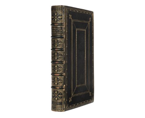
Sibbald (Robert). A Collection of Several Treatises in Folio, Concerning Scotland, as it was of old and also in later times. Viz. I. Historical Inquiries concerning the Roman Monuments and Antiquities... II. The History, Ancient and Modern, of the Sheriffdoms of Fife and Kinross... III. Conjectures concerning Roman Ports... IV. The History and Description of the Sheffifdoms of Linlithgow and Stirling...V. The Description of the Isles of Orknay and Zetand... VI. An Account of the Writers ancient and modern..., 1st edition, Edinburgh, 1739, general title, 6 parts, each with separate title pages and register, 14 engraved maps and plates, most folding, bound with Tractatus Varii ad Scotiae Antiquae & Modernae Historiam Facientes: in Unum collecti, & jam primum editi. Cum Tabulis Aeneis. Viz. Introductio ad Historiam rerum a Romanis gestarum... Specimen Glossarii... Commentarius in Julii Agricolae Expeditiones, 3, 4, 5, 6, 7, Series rerum ab aliis Praefectis Romanis... Miscellanea quaedam eruditae Antuitatis... Vindiciae Scotiae illustratae...Edinburgh, 1711, general title, 4 parts, each with separate title pages and register folding engraved map, advertisement leaf at end, one or two small repairs, occasional light spotting and toning, previous owner inscription, 1844 to front endpaper, bookplate, all edges gilt, later blue morocco gilt, joints and spine bands a little rubbed, small folioQty: (1)NOTESESTC T131329 & T131328 respectively. A handsome copy.
Lot 448
Shakespeare (William). The Plays... , from the Text of the corrected copies left by the Late George Steevens and Edmond Malone... , and a Life of Shakespeare, by Alexander Chalmers, 8 volumes, new edition, Longman and others, 1847, engraved portrait frontispiece to volume 1, half-titles, a little spotting, contemporary polished calf gilt, neatly rebacked in calf gilt with contrasting leather labels, together with: Burns (Robert) , The Poetical Works, edited by George Gilfillan, 2 volumes, Edinburgh, 1856, contemporary polished calf, gilt-decorated spines with contrasting leather labels, rubbed, plus Tombleson (William) , Eighty Picturesque Views on the Thames and Medway... , Black & Armstrong, circa 1840, 80 steel-engraved plates including additional title, some spotting throughout, panoramic map not present, all edges gilt, original embossed calf gilt, rebacked with original spine relaid, rubbed and faded, 4to, plus other mostly 19th-century leather bindings, 4to/8voQty: (30)
Lot 45
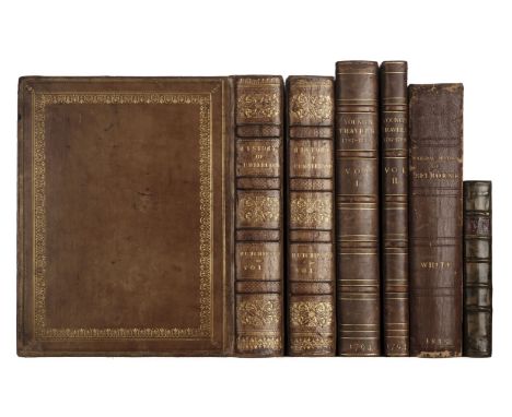
Hutchinson (William). The History of the County of Cumberland, and Some Places Adjacent, 2 volumes, 1st edition, Carlisle: printed by F. Jollie, 1794, 2 engraved additional title-pages, 57 engraved plates and plans (several folding), engraved vignettes throughout the text, including plate 'North East View of the City of Carlisle' and mounted vignette 'A View from the High Ground a little to the East of Heraby' either side of pp. 585/6 (the plate apparently not accounted for in Upcott, the vignette intended to replace the vignette on p.585 sometimes 'worn faint in printing'), 3 leaves of tables (one folding), volume 1 quire H irregularly signed and paginated, offsetting, occasional light spotting, one folding plan (Whitehaven) abraded along fold and with repairs, contemporary bookseller's tickets (Rowe & Waller) to front free endpapers, contemporary tan calf gilt, rebacked with original spines laid down, 4to (27.6 x 21.5 cm), together with: Young (Arthur). Travels during the Years 1787, 1788, and 1789; undertaken more particularly with a View of Ascertaining the Cultivation, Wealth, Resources, and National Prosperity of the Kingdom of France, 2 volumes, 2nd edition, London [-Bury St Edmunds]: for W. Richardson, 1794, viii 629 [3], [2] 336 [4] pp., 3 engraved folding maps (1 hand-coloured), half-title to volume 2, maps browned, occasional spotting, bottom edges untrimmed, 20th-century half calf for Bumpus, 4to (29.4 x 22.2 cm), White (Gilbert). The Natural History and Antiquities of Selborne ... New Edition, with Engravings, London: for White, Cochrane, and Co. [and others], 1813, pp. x 587 [1], half-title, engraved folding map frontispiece, additional vignette title, 8 engraved plates (one hand-coloured), a few marks and marginal repairs, occasional marginalia (once on pasted slip), bookplate (Samuel Henshaw), manuscript pen-and-ink sketch map to front pastedown, fore and bottom edges untrimmed, contemporary boards, rebacked and recornered, 4to (26.6 x 19.4 cm), and 1 other (Shrubsole, The History and Antiquities of Rochester, 1st edition, 1772, not collated)Qty: (6)NOTESESTC T139564 (Hutchinson), T78081 (Young); Freeman 3976.2 (White); Kress B.2872 (Young); Upcott I pp. 108-113 (Hutchinson).

Lot 46
Lambarde (William). A Perambulation of Kent: Conteining the description, Hystorie, and Customes and that Shyre, 1st edition, London: Ralph Newberie, 1576, title within ornamental border, text mainly in black letter with occasional Anglo-Saxon characters, numerous figurative and criblé woodcut initials, bound with the extra leaf signed H2, lacking map (English Heptarchi), with folding woodcut map of Carde of the Beacons in Kent inserted before title (slight worming at head), early annotations and marginalia throughout, some light dampstaining at rear, armorial bookplate of Gilbert Compton Elliot to upper pastedown, later endpapers, contemporary sheep, rebacked preserving morocco title label, small 4toQty: (1)NOTESSTC 15175; ESTC S108236.

Lot 47
Lewis (Samuel). Atlas to the Topographical Dictionary of England comprising a General Map of England, a Plan of London and Maps of the counties..., 1845, title page, folding general map of England and Wales with contemporary outline colouring, closed tear affecting image, an uncoloured folding plan of London engraved by J & C Walker and 41 engraved maps, all with contemporary outline colouring, including 13 folding, slight spotting throughout, contemporary blind-stamped cloth, worn and rubbed, 4to, together with another copy similar but lacking the folding maps of England & Wales, London and Yorkshire, all of the maps in the second volume have a library blind stamp affecting the printed image, contemporary cloth, worn at extremities, 4toQty: (2)
Lot 50
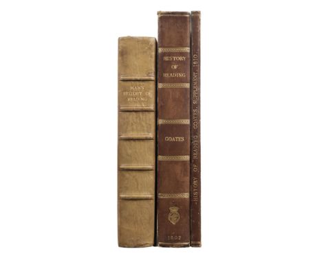
Man (John). The History and Antiquities, Ancient and Modern, of the Borough of Reading, in the County of Berks, 1st edition, Reading: Snare and Man, 1816, folding engraved frontispiece plan of Reading, 12 plates only (21) including engraved 2 folding plans and several uncoloured aquatint views, with 2 additional 19th century pen & ink plans of Reading after Speed's county map, manuscript annotation at foot of title-page and few annotations throughout, interleaved with several blank leaves with manuscript notes and additional manuscript index at rear, light toning, 20th century half calf, marbled sides, 4to, together with: Coates (Charles) , The History and Antiquities of Reading, London: Printed for the Author, by J. Nichols and Son, 1802, folding engraved map frontispiece, 6 uncoloured aquatint plates (1 folding) and one plan, together with A Supplement to the History and Antiquities of Reading, with Corrections and Additions by the Author, Reading: Printed by Snare & Man, 1810, folding uncoloured aquatint frontispiece, some toning and spotting, ink stamp at foot of title-page, uniform early 20th century half morocco, gilt armorial at foot of first volume (History and Antiquities of Reading, 1802), joints rubbed, 4toQty: (3)NOTESAbbey Scenery 293; Upcott p.583.
-
109198 item(s)/page