We found 109198 price guide item(s) matching your search
There are 109198 lots that match your search criteria. Subscribe now to get instant access to the full price guide service.
Click here to subscribe- List
- Grid
-
109198 item(s)/page


Lot 835
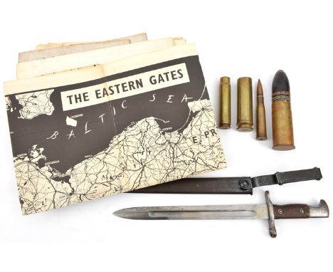
A US Model 1892 bayonet for the Krag Jorgensen rifle, the blade dated 1899, in its scabbard with steel belt attachment, GC; a WWI German 37mm pom pom shell case with explosive shell in fired condition; 3 other small shell cases; 11 1940 War Edition linen backed OS maps, mostly of northern England; 3 similar part maps of Moscow, Berlin and Frankfurt; 2 other maps; and a map/poster, “The Eastern Gates”, of the Baltic States etc, and on the other side a propaganda poster showing caricature sketches of the German leaders, photographs of the Russian and allied leaders, map of Europe etc. Average GC


Lot 16
Ludovik BodenRules of Engagement IIIcast bronzeH 8.5cm W 8cm D 8cmLudovik Boden (b. 1963) writes: "An interest in the diagram, the model, the toy, the icon, the game and the map keep me intrigued by the possibilities of the smaller scale and constantly remind me that all conceptual and representational schema inevitably involve reduction, simplification and concision."


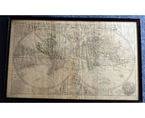
Lot 360
A large ebonised framed and glazed Queen Ann period (dated 1709) hand coloured Map Engraving "A New and Correct Map of The World Laid Down According to The Newest Discoveries and From The Most Exact Observations" by Herman Moll, Geographer and dedicated to His Royal Highness George, Prince of Denmark, Lord High Admiral Great Britain and Ireland, 64cm x 104cm CONDITION REPORT: Upon first inspection the paper is noted to have vertical creases and ripples (mostly near the centre area), there is also some discolouration evident mostly to the border area of the Map and where the dedication is (lower centre) further damage/rippling of the paper is noted in the margin. Other minor tears and rippling are also noted although no major tears or rips appear prevalent.


Lot 401
GILPIN (William) Observations .... Picturesque Beauty... Mountains and Lakes of Cumberland and Westmoreland, 2 vols, 1786 , 8vo, plates including folding, tree calf gilt spines; GILPIN (William) Observations .... Highlands of Scotland, 2 vols, 1789, 8vo, plates, half calf gilt spines; also - MAWMAN (J) An Excursion to the Highlands of Scotland, and the English Lakes. 1805, 8vo, folding map, uncut, half calf (worn) (5)

Lot 404
Literature and travel. LAVELEYE (Emile de) The Balkan Peninsula, 1887, 8vo, folding map, cloth; GORDON (J & C) Two Vagabonds in the Balkans, 1925, plates; ALEXANDER (N) Wanderings in Yugoslavia, 1936, folding map, cloth; STANFORD's 'Col Rhodes' Map of Africa, 67 x 56cm; COLLINS' Enlarged Map of Russia and Turkey, 53 x 88cm; various others including bindings, Hogarth's Works, Johnson's Dictionary in miniature, Glasgow 1820, etc (23)
Lot 358
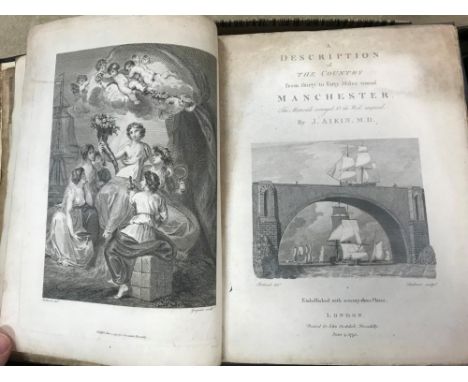
AIKIN (J) A Description of the Country from thirty to forty miles round Manchester, London: for John Stockdale 1795, 4to, engraved frontispiece and added vignette title, large folding linen backed plan, folding map, plates, first and last leaves somewhat worn and slightly soiled, marginal browning or foxing, later half morocco; PENNANT (T) The Journey from Chester to London, 1782, 4to, plates as called for, light foxing, later half calf (2)
Lot 410
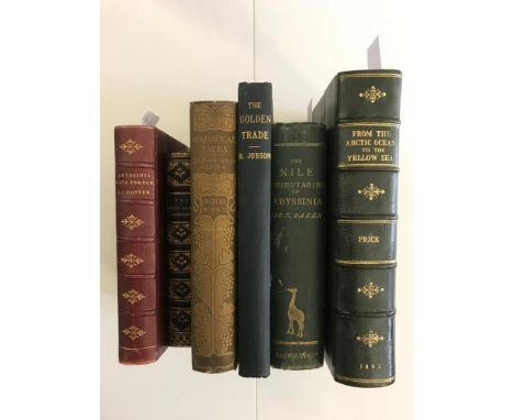
Travel. PRICE (Julius M.) From the Arctic Ocean to the Yellow Sea. London 1892, 8vo, portrait frontispiece, folding map, illustrations, modern half morocco; HOTTEN (John C) Abyssinia and its People, 1868, 8vo, folding map, coloured plates; BAKER (Sir S) The Nile Tributaries of Abyssinia, 1871, 4th edition, cloth; [BONAR (A)] The Holy Land, 1844, 12mo, full morocco gilt; 2 others, cloth (6)


Lot 84
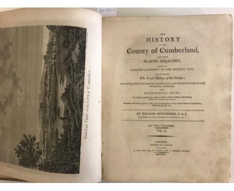
RUSHWORTH (John) The Tryal of Thomas, Earl of Strafford, Lord Lieutenant of Ireland, Upon an Impeachment of High Treason by the Commons Then Assembled in Parliament. London: John Wright and Richard Chiswell, 1680, folio, engraved damaged portrait frontispiece, somewhat soiled and age worn in places, rebacked contemporary calf (worn); HUTCHINSON (W) The History of the County of Cumberland, in 2 vols 1794, 4to, lacking the map, with plates and folding plans, some losses, tears and damage, also lacking one board, damaged binding. WHITE (G F) Views in the Himalaya Mountains, 1837, folio, part II only, 14 'subscribers proof' plates, some foxing, binding rubbed. Sold not subject to return (4)

Lot 205
FORBY (Robert) The Vocabulary of East Anglia, in 2 vols. London 1830, 8vo, calf, rebacked; KIRBY (John) The Suffolk Traveller. Woodbridge (no date c.1780), folding map, toned, calf; GLYDE (John) Suffolk in the Nineteenth Century, no date, 8vo, inscribed 'from the author', cloth, worn; and 10 others later - mostly East Anglia (14)

Lot 34
Ptolemy. Map of Great Britain and part of Europe, Latin text to verso 'Europae Tabula Prima continet Insulam Albion, sive Britanniam & Hyberniam', double page, 16th century, possibly from Michael Servetus's (1511?-1553) second edition of Ptolemy's work on geography, Lyon 1541 [see a similar map in the collection of St John's College Cambridge], with margins, 41 x 54cm (overall) tear into right margin without loss

Lot 130
WRIGHT ( Rev. G N) The Shores and Islands of the Mediterranean, illustrated after Sir Grenville Temple and others. Fisher Son & Co c.1840, 4to, folding map, plates, sporadic typical staining, half calf gilt; MOTLEY (J) The Dutch Republic, 3 vols 1875, 8vo, full calf; together with 4 volumes of poetry in leather bindings (8)

Lot 403
KLAPROTH (Julius) Asia Polyglotta - Sprachatlas. Paris 1823, oblong folio, with language tables and coloured double page map of Asia, detached covers; WARREN (J. G. H.) A Century of Locomotive Building by Robert Stephenson & Co. 1823-1923, plates, cloth; Badminton Library - Shooting, Hunting and Big Game Shooting, original cloth (5)

Lot 79
New and Complete History of America, vol. II only c.1750-60, 8vo, lacks title, with folding coloured map of 'New York, Pensilvania (sic), New Jersey and Maryland' engraved by R. W. Seale, 26 x 20.5cm, and State House of Philadelphia plate, upper board detached; ANSON (George) A Voyage Round the World, 15th edition, 1780, 8vo, 2 folding maps (of 3), detached boards; one other. Sold to benefit a charity. (3)
Lot 409
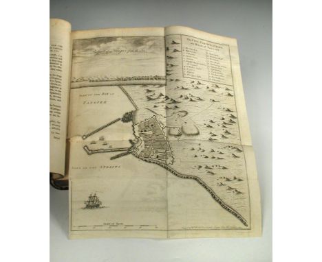
THOMAS (Lieut. Col. James) The History of the Herculean Straits, now called the Straits of Gibraltar, including those Ports of Spain and Barbary that lie contiguous thereto. London: for Charles Rivington, 1771, 4to, 2 vols. in one, folding frontispiece map torn without loss, contemporary manuscript index at the front, plates as required, rebacked calf

Lot 178
Folding maps. A collection of various folding, tourist and other maps and guides, British and Continental, some linen backed, including - "The Car" leather case of 8 'Holland's Patent Duplex' motor maps for Scotland, c.1920s; a Crimean 'Seat of the War' map in wallet, 'Country Around Bournemouth' wallet of 4 Stanford OS maps, sheets 314, 315, 329, and 330; etc


-
109198 item(s)/page