We found 109198 price guide item(s) matching your search
There are 109198 lots that match your search criteria. Subscribe now to get instant access to the full price guide service.
Click here to subscribe- List
- Grid
-
109198 item(s)/page


Lot 199
America. Danckerts (Justus), Recentissima Novi Orbis sive Americae Septentrionalis et Meridionalis Tabula, Amsterdam, [c.1690], eng. map with orig. hand col., central fold a little creased, slight staining and dust soiling, three margins strengthened on verso, 500 x 575 mm. R.V.Tooley, The Mapping of America, pp.124, no.53. A reissue of the Visscher/De Wit map showing California as an island, and a speculative outline sketching of the Northern coastline of Australia. (1)
![British Isles. Porcacchi (Tommaso), Descrittione Dell Isola D"Inghilterra, Venice, [1572 or later], uncoloured eng. map](http://lot-images.atgmedia.com/SR/10729/2775054/200_468x382.jpg)
Lot 200
British Isles. Porcacchi (Tommaso), Descrittione Dell Isola D"Inghilterra, Venice, [1572 or later], uncoloured eng. map orientated to the east, tablet cartouche supported by two mermaids, heavily stippled sea area decorated with a compass rose and sea monsters, map size 110 x 150 mm, Italian text below and on verso of map, together with Descrittione Dell Isola Di Scotia,uncoloured eng. map orientated to the east, tablet cartouche supported by putti, heavily stippled sea area decorated with a compass rose, sea monsters and sailing galleys, map size 105 x 145 mm, Italian text below and on verso of map. R.W Shirley, Early Printed Maps of the British Isles 1477-1650, no.97. (2)
Lot 201
Buckinghamshire. Bowen (Emanuel), An Accurate Map of Buckinghamshire Divided into its Hundreds Drawn from the best Authorities assisted by the most Approved Modern Maps, [1762 or later], lg. eng. map with orig. outline col., elaborate b & w cartouche, slight fraying to margins, central fold strengthened on verso, slight soiling and spotting, 700 x 535 mm (1)
![China. Homann (Johann Baptist, Heirs of), Regni Sinae vel Sinae Propiae, [1750 or later], eng. map with orig. hand col., elab](http://lot-images.atgmedia.com/SR/10729/2775054/203_468x382.jpg)

Lot 204
Delisle (Guillaume). Carte De L"Isle et Royaume de Sicile, Paris, 1717, uncoloured eng. map , inset map of Malta and Gozo, 480 x 590 mm, together with Carte de L"Isle de Saint Domingue, Paris, 1725,uncoloured eng. map, 480 x 630 mm, with Carte des Cotes de Malabar et de Coromandel, Paris, 1723,uncoloured eng. map, 440 x 590 mm, slight staining, occ. marginal closed tears, with another twenty-five similar maps, all by DeLisle, mostly of Europe, various sizes and condition (28)

![England & Wales. Jansson (Jan), Anglia Regnum, [1646 or later], eng. map with orig. hand col., 395 x 505 mm, Latin text o](http://lot-images.atgmedia.com/SR/10729/2775054/206_468x382.jpg)

Lot 207
Holy Land. Seutter (Georg Matthaus), Regio Canaan seu Terra Promissionis Postea Judaea vel Palaestina Nominata Hodie Terra Sancta, [1725 or later], eng. map with orig. hand col., elaborate uncol. cartouche, inset map of Egypt, the Red Sea and Sinai, very occ. marginal closed tears (one repaired), very slight spotting, 505 x 585 mm (1)

Lot 208
India. Walker (J & C), A Newly Constructed and Improved Map of India, Compiled Chiefly from Surveys Executed by Order of the Honble. East India Company, London, Wm. H. Allen & Co., 1844, lg. eng. map with orig. hand col., sectionalised and laid on two linen sheets, calligraphic title, slight browning to old folds, overall size approx. 1600 x 3050 mm, contained in orig. cloth slip case with gilt dec. title to spine, water stained and frayed at base (1)

Lot 209
Italy. Duchetti (Claudio), Explicatio Aliquot Locorum Quae Puteolis Spectantur, Rome, 1586, uncoloured etched map of the Italian coastline around the port of Pozzuoli, due west of Naples, lg. table of explanation with a "picture frame" border, 395 x 510 mm. Duchetti was one of the more active engravers of the sheet maps which were published under the generic title of Lafreri atlases. These atlases have a varying content, usually lack any title and are rare. (1)

Lot 217
North America. Euler (Leonhard), Mappa Geographica Americae Septentrionalis ad Emendatiora Exemplaria adhuc edita....[1753 or later], fine hand col. eng. map of North America, Eastern Canada and the West Indies, four decorative cartouches, inset map of Hudson Bay and the Hudson Strait, four sheets conjoined, each sheet with unobtrusive Russian crest, one small closed tear to old fold, occ. old marginal repairs, narrow margins, 670 x 685 mm (1)

Lot 218
North America. Homann (Heirs of), America Septentrionalis a Domino d"Anville in Galliis edita nunc in Anglia Coloniis in Interiorem Virginiam deductis nec non Fluvii Ohio cursu......Nuremberg, 1756, eng. map with orig. outline col., elaborate uncoloured strapwork cartouche, occ. rust marks, slight dust soiling, some marginal water staining not affecting image, 470 x 520 mm (1)
Lot 219
Norway. De Wit (Frederick), Norvegia Regnum Divisum in suos Dioeceses Nidrosiensem, Bergensem, Opsloensem et Stavangriensem et Praefecturam Bahusiae, [1670 or later], hand col. eng. map, elaborate cartouche and an inset map of the northern Norwegian coastline, central fold strengthened on verso, horizontal margins partially trimmed and repaired, not affecting image, 600 x 510 mm (1)
![* Oxfordshire. Plot (Robert), The Map of Oxfordshire, [1677 or later], hand col. eng. map, old folds, 505 x 485 mm, framed an](http://lot-images.atgmedia.com/SR/10729/2775054/221_468x382.jpg)

Lot 224
Scandinavia. Visscher (Nicolaes), Tabula Exactissima Regnorum Sueciae et Norvegiae nec non Maris Universi Orientalis, [c.1680], eng. map with orig. outline col., elaborate cartouche, upper border trimmed and affecting strapwork margin, 455 x 550 mm, French text on verso. This map is copied from the original survey by Andreas Bure (1571-1661). He is mentioned in the title cartouche. The map title credits the cartographer as "Piscatore"; this is simply the Latinised version of Visscher. (1)

Lot 226
Sussex. Greenwood (C & J), A Map of the County of Sussex from an Actual Survey made in the Years 1823 & 1824, very lg. uncoloured eng. map, sectionalised and laid on linen, calligraphic title, table of explanation and reference to the hundreds, vignette engraving of Chichester Cathedral, slight soiling, 1260 x 2080, framed and glazed. Not examined out of frame. (1)

Lot 227
United States. Mitchell (S.Augustus), Mitchell`sNational Map of the American Republic or United States of North America, Philadelphia, 1845, lg. engraved wall map with orig. hand col., elaborate strapwork borders with thirty-two eng. town plans surrounding the map, calligraphic title, printed on four sheets, varnished and laid on linen, some surface cracking, supported with contemp. stained wooded battens, 930 x 1160 mm (1)

Lot 228
United States. Ensign (T. & E.H.), Ensign`sTravellers" Guide and Map of the United States, Containing the Roads, Distances, Steam Boat and Canal Routes &c., New York, 1845, lg. eng. wall map with orig. hand col., varnished and laid on linen, decorated with fifteen inset maps of the vicinity of major cities, a small hemispheral map of the world, the Declaration of Independence, ten eng. portraits of American Presidents, five vignettes of American historical scenes and a large engraving of the signing of the Declaration of Independence, some surface cracking and fraying to margins, water colour showing signs of oxidisation, supported on orig. stained wooden battens, 650 x 960 (1)
Lot 229
Worcestershire & Warwickshire. Blaeu (Joan), Wigoriensis Comitatus et Comitatus Warwicensis; nec non Coventrae Libertas, Worcester, Warwik Shire and the Liberty of Coventre, [1645 or later], uncoloured eng. map, elaborate strapwork cartouche, several marginal closed tears with some affecting image, strengthened with archival tissue on verso, 415 x 505 mm, Latin text on verso, together with Moule (Thomas), Lancashire, c,1848,uncoloured eng. map, some spotting, 260 x 200 mm, together with another 55 county maps by the same cartographer, and approx. another twenty-four British county maps by Lewis, Archer, Bowen, Langley, Starling, Pigot and Teesdale, various sizes and condition (approx.80)

Lot 230
World. Mount (William & Page Thomas, pub.), A Correct Chart of the Terraqueous Globe, According to Mercator`sor more Properly Wright`sprojection, 1756, hand col. eng. map on three sheets conjoined, four decorative strapwork cartouches, inset semi-circular map of the North Pole, slight profesional restoration on verso, left hand margin strenghtened, 520 x 1430 mm. This map is often credited to Edmund Halley who first published this large world map in 1702. The engraver was William Mountaine and although the map underwent several amendments and alterations including editions by Pierre Mortier, R and J Ottens and Laurie and Whittle, it remains scarce. (1)
Lot 268
Illustrated London News, vol. 13, July-December, 1848, vols. 18-21, May 1851-December 1852, vols. 23-27, July 1853-December 1855 & vol. 53, July-December 1868, num. wood-engs., some folding (Including interior of the Crystal Palace Hyde Park, 1851; Exterior of the Crystal Palace erected in Hyde Park for the Exhibition of the Industry of All Nations (south-east view); London in 1851; Map of Paris, with the latest Improvements, 1855; Funeral of the Duke of Wellington in St. Paul`sCathedral, November 18, 1852; Wellington`sFuneral Car; The British Fleet at Spithead in July 1853; Sebastopol - First Day`sAttack by the Allied Fleet and Armies of France and England; and a few others), together with a bound vol. of The Pictorial Times, vols. 7-9, April 1846-April 1847, all contemp. half calf gilt, some wear, folio (12)

Lot 296
* Trade cards. A collection of ninety-seven late 19th c. Continental trade cards depicting French Departments, fine chromolithographic printing, some heightened with gold, each depicting a map of the Department set against a scenic background incorporating arms of the Department, produce and sometimes a medallion portrait of an historical figure, nine cards have printed backs and measure 8.5 x 11.5 cm, the remainder have plain backs and measure 8 x 11 cm. All in fine condition (97)

Lot 416
Rhodes (Alexandre de). Tunchinensis Histori? libri duo, quorum altero status temporalis hujus regni. Altero mirabiles Evangelic? Pr?dicationis progressus referuntur. Coept? per patres Societatis Jesu, ab Anno 1627 ad Annum 1646, 2 parts in one, 1st Latin ed., Lyon, Joan Bapt Devenet, 1652, vign. title-page, folding eng. map, eng. head-pieces and initial letters, lightly browned and foxed, 18th c. calf, rebacked preserving orig. gilt dec. spine (rubbed), corners showing, sm.4to. This important early work on Vietnam was first published in French in Rome in 1650. Jesuit priest Alexandre de Rhodes (1591-1660) devoted most of his life to missionary work in Vietnam. Not only did he convert many of the people to Christianity, he also wrote the first Vietnamese catechism and had a lasting effect on Vietnamese writing. A gifted linguist, he mastered Vietnamese in only six months, compiled the first Portuguese-Latin-Vietnamese dictionary, and was one of the first to attempt to Romanize the Vietnamese alphabet. Today the national language of Vietnam, Quoc Ngu, is based on his original transliterations and phonetic work. Rhodes`smissionary work was constantly at odds with the local pagan priests and he was exiled twice and nearly sentenced to death for his teachings. Rhodes said in his reports that he converted more than 6,000 Vietnamese, almost certainly an inflated number, but nevertheless he did win converts. He also worked as a missionary in China, Macao and Persia, but his true love was for the Vietnamese people. (1)
Lot 443
Vogel (Franz Adam). Les privil?ges des Suisses, Ensemble ceux Accordes aux Villes Imperiales et Anseatiques, et aux Habitans de Gen?ve, Residens en France..., Paris: Pierre Prault, 1751, ownership bookplates to front pastedown inc. that of Colonel Vogel, contemp. sheep, gilt dec. spine with red morocco title label, upper board with later gilt armorial of the Paravicini family, rubbed and scuffed, 4to, together with Laborde (Jean-Benjamin de), Lettres sur la Suisse, Adressees a Madame de M * * * PAr un Voyageur Francois, en 1781, 2 vols., Geneva, 1783, hand-col. eng. map, two folding plans, a.e.g., near contemp. gilt dec. marbled calf, gilt armorial of the Paravicini family to upper boards, extrems. slightly worn, 8vo, with [Curti, Leopolde], Lettres sur la Suisse, 2 parts in one, Altona, 1797, a.e.g., contemp. crushed red morocco gilt, some wear & torn leather to upper panel of spine, 8vo, plus forty-two other 18th/19th c. antiquarian (46)
Lot 467
[Halley, Edmund, ed.]. Miscellanea Curiosa. Containing a Collection of some of the Principal Phaenomena in Nature, accounted for by the Greatest Philosophers of this Age; being the most valuable discourses, read and deliver"d to the Royal Society, for the advancement of physical and mathematical knowledge, 3 vols., 1726, 1723, & 1727, respec., twenty (of twenty-one) eng. plts., many folding, including world map, one or two marks to plates with consequent minor repairs, recent antique-style two-tone blind-panelled full calf, gilt dec. spines with morocco title label to each, 8vo. Babson 237. Wallis 393.457. Third edition of volume 1 and second editions of volumes 2 and 3 (as often). An important collection of papers, containing contributions by Sir Isaac Newton (The True Theory of the Tides, New Theory about Light and Colours, & The Theory of the Moon), Robert Hooke, Edmund Halley, Abraham De Moivre, John Wallis, and others. (3)
Lot 570
Edge (S.F.). My Motoring Reminiscences, 1st ed., c. 1934, portrait frontispiece, photographic illustrations, map endpapers, one or two light spots, original cloth, slightly rubbed, price-clipped d.j., 8vo, together with The Book of Speed, 1934, coloured frontispiece, b & w plates, a few light spots, small inscription, original cloth, faded patches, d.j., small marginal loss to upper panel, repairs, some soiling and pencil sketches to verso, 4to, with others motoring and transport related (44)
Lot 610
Dixon (James). Methodism in America: With the Personal Narrative of the Author, During a Tour Through a Part of the United States and Canada, printed for the author, 1st ed., 1849, engraved folding map frontispiece, one or two light spots, front hinges broken, contemporary calf, a little rubbed and scuffed, 8vo, together with Merle (William-Henry), Odds and Ends. In Verse and Prose, 1831, plates and illustrations by George Cruikshank, front hinges broken, occasional light spotting, original cloth-backed boards, rubbed and stained, 8vo, plus Hood (P.), Practical Observations on the Diseases Most Fatal to Children; With Reference to the Propriety of Treating Them as Proceeding From Irritation and not from Inflammation, 1845, adverts. at front, a few light spots, hinges cracking, original blindstamped cloth, spine ends chipped, rubbed and faded, 8vo, with others including A General History of the County of Norfolk, Intended to Convey all the Information of a Norfolk Tour, 2 vols., 1829 (somewhat worn), J. Henry Harris`sA Romance in Radium, 1906 and Buster Brown, his Dog Tige and their Troubles, c. 1904 (a carton)
Lot 612
Grillo (Luigi). Favole, Esopiane in Versi, 1795, ms. ownership signatures on prelim. blanks, marbled endpapers, a.e.g., contemp. straight-grained red morocco gilt, rubbed and scuffed, 12mo in 6s, together with Prescott (William H.), History of the Conquest of Mexico, with a Preliminary View of the Ancient Mexican Civilisation, and the Life of the Conqueror, Hernando Cortes, 3 vols., 8th ed., 1860, half-titles, eng. port. frontis. to each vol., vols. 1 and 2 with folding map, vol. 3 with facsimile plt., uniformly bound with History of the Conquest of Peru, with a Preliminary View of the Civilisation of the Incas, 3 vols., new ed., 1862, half-titles, eng. frontis. to each vol., vol. 1 with folding map, marbled endpapers and edges, contemp. calf, gilt dec. spines, extrems. rubbed, some spine labels chipped or lacking, 8vo, plus The Works of Daniel Defoe, 15 (of 16 vols.), Boston, 1903, orig. red cloth gilt, extrems. rubbed, occn. wear and marks, and The Magazine of Art, 10 vols., 1880s, all but one vol. orig. cloth, rubbed, folio/4to (2 cartons)
Lot 622
Shiercliff (E.). The Bristol & Hotwell Guide; Containing an Account of the ancient and present State of that Opulent City; Nature, and Effect of the Medicinal Water of the Hotwells; Botanical Plants and beautiful Views of Clifton..., 4th ed., Bristol, [1809], folding eng. map frontis. (with some closed-tears to folds), title torn to lower outer corner, four eng. plts. (one hand-col. and one folding), sewing weak and few leaves loose, orig. printed boards, lacks spine, 12mo, together with Kelly`sDirectory, Dorsetshire, 1935, folding hand-col. map frontis., orig. cloth, upper joint split and frayed, tall 8vo, with Menpes (Mortimer), China, pub. A. & C. Black, 1909, col. frontis., plts. and b & w illusts., orig. cloth gilt, slightly rubbed at head & foot of spine, 4to, plus other misc. antiquarian etc. (a carton)
Lot 634
Nesbitt (F.). Ilfracombe Parish Church, 1st ed., pub. John Moore, Ilfracombe, 1901, b & w illusts. from photos, a.e.g., contemp. crimson morocco gilt by J.P. Gray & Son, Cambridge, slim 8vo, together with Page (John Lloyd Warden), The Coasts of Devon and Lundy Island. Their Towns, Villages, Scenery, Antiquities and Legends, 1st ed., 1895, b & w illusts., folding map at rear, orig. cloth gilt, minor wear to head and foot of spine, 8vo, plus Robinson (W. Heath), Bill The Minder, [1912], sixteen tipped in col. plts., b & w illusts. to text (some coloured by a juvenile hand), orig. dec. cloth, faded on spine, large 8vo, with other miscellaneous books including a few antiquarian and leather bindings, pocket editions, etc. (3 shelves)
Lot 650
Lloyd (Rev. W.V.). The Sheriffs of Montgomeryshire, with their Armorial Bearings, and Notices, Genealogical and Biographical, of their Families, from 1540 to 1639, published by subscription, 1876, folding tables, armorials to text, orig. cloth gilt, rubbed and some minor wear, new endpapers, 8vo, together with Owen (George of Henllys, Lord of Kemes), The Description of Penbrokshire, 4 parts bound in 3, 1892-1936, folding map, armorials, facsimile documents, etc., recent blue cloth gilt, large 8vo, plus RCHM, An Inventory of the Ancient Monuments in Caernarvonshire, vols. 1-3 (East/Central/ West), 1956-60-64, num. b & w illusts. from photos, diags., orig. cloth in d.j., 4to, and others of Welsh interest (3 shelves)
Lot 652
[Coleridge, Henry Nelson]. Six Months in the West Indies, in 1825, 2nd ed., with additions, 1826, map frontis., untrimmed, orig. boards, worn on spine, together with M. Fabii Quintiliani, Declamationes... , vol. 2 only, ex officina Hackiana, 1665, addn. eng. frontis., contemp. red morocco, gilt-dec. spine with raised bands, rubbed, 8vo, with other miscellaneous antiquarian, etc. (3 shelves)

Lot 2
Ainsworth (William). Researches in Assyria, Babylonia and Chaldaea; forming part of the Labours of the Euphrates Expedition, 1st ed., 1838, tinted litho. frontis., title page with wood eng. topographical vignette, torn with loss but professionally repaired, folding b & w eng. map with slight off-setting, three folding hand col. litho. geological cross-sections, slight fraying to fore edges of folding plts., orig. cloth gilt, spine faded, 4to (1)

Lot 3
Amundsen (Roald). The South Pole. An Account of the Norwegian Antarctic Expedition in the "Fram", 1910-1912, trans. A. G. Chater, 2 vols., 1st English ed., 1912, num. b&w illusts. from photos., maps and charts etc. (some folding), occ. spotting, some staining to rear endpapers of vol. 1 (slightly affecting lower margin of folding map at rear), t.e.g., orig. maroon cloth gilt, some fading, large 8vo (1)
Lot 5
Baker (Samuel White). Ismailia. A Narrative of the Expedition to Central Africa for the Suppression of the Slave Trade, Organized by Ismail, Khedive of Egypt, 2 vols., 1874, eng. port. frontis. to each, wood eng. plts. (one plt. with small repair), folding map (tape repairs to verso), occ. spotting, contemp. half calf gilt, contrasting labels to spines, rubbed, 8vo (2)
Lot 8
Battersby (H.F. Prevost). Richard Corfield of Somaliland, 1st ed., 1914, eighteen b&w plts and folding map at rear (as list), occ. spotting, orig. cloth gilt, spine dulled, rubbed, 8vo, together with Johnston (Sir Harry), The Uganda Protectorate..., 2 vols., 1902, col. and b&w plts. throughout, folding col. maps, ex-lib., ink stamps to titles, t.e.g., remainder untrimmed, orig. gilt dec. cloth, lib. nos. and sticker to spines, wear to extrems., 4to, plus Bovill (E. W.), Missions to the Niger, 4 vols., Cambridge, 1964-66, b&w frontis to each, b&w plts. and folding maps, orig. gilt dec. cloth, 8vo, plus twenty-threee other largely Africa related (30)
Lot 10
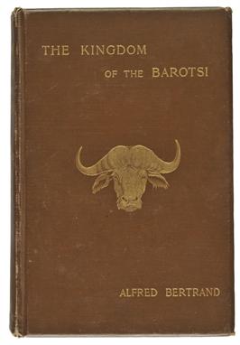
Bertrand (Alfred). The Kingdom of the Barotsi, Upper Zambia. A Voyage of Exploration in Africa, Returning by the Victoria Falls, Matabeleland, the Transvaal, Natal and the Cape, translated by A.B. Miall, 1899, portrait frontispiece, b & w plates and illustrations, two folding maps at end, one with short closed tear, some marginal fraying, one loose folding map of Rhodesia, a few light spots, hinges a little cracked, original cloth gilt, lightly rubbed, t.e.g., 8vo. Author`spresentation inscription to half title, with a 4pp. signed autograph letter, dated July 1902. (1)
Lot 14
Brydone (Patrick). A Tour through Sicily and Malta, in a Series of Letters to William Beckford, 2 vols., 3rd ed., corrected and enlarged, Dublin, 1775, sl. marginal browning, contemp. calf with leather labels to spines, joints cracked and sl. wear to extremities, 12mo. This printing apparently issued without the folding map. (2)
Lot 19
Dampier (William). A New Voyage Round the World, Describing particularly the Isthmus of America, Several Coasts and Islands in the West Indies..., their Soil, Rivers, Harbours, Plants, Fruits, Animals and Inhabitants..., 1st ed., James Knapton, 1697, pp.[10],VI,550,[4], folding eng. double-hemisphere map of the world by H.Moll showing California as an island, four other eng. maps (inc. 3 folding), foding map of East Indies torn to fold and with old repair to verso, lower outer corner of leaf F1 torn with slight loss, closed-tear to leaf S1 crudely repaired, slight dust soiling and few marks, bookplate and manuscript notes to front pastedown, lacks front free endpaper, contemp. calf, lacking lower board, upper joint cracked and worn to spine, 8vo (Wing D161), together with Carey (Frances Jane), Journal of a Tour in France, in the Years 1816 and 1817, pub. 1823, paper repair to inner margin of half-title and title, contemp. diced calf with gilt dec. spine (faded), 8vo, plus three others including odd volumes (5)

Lot 20
De Wit (Frederick). Atlas, Tot Amsterdam Bij Frederick de Wit in de Calverstraet bij den Dam inde Witte Paskaert, [1688 or later], dec. hand col. allegorical frontis. of Atlas standing on the earth holding up the sky, near contemp. ink annotation in lower margin, 105 highly decorative eng. maps with orig. hand col. (complete as list), by De Wit, Visscher, Sanson, Dankerts and others, near contemp. ink number on verso of each map, one map with marginal repaired tears, occ. adhesion along central fold, some marginal water staining and light spotting to last few maps, index bound in at rear, upper hinge broken, 19th century qtr. morocco gilt, bumped and frayed at extrems., folio. Koeman III, Wit 11, p.199. (1)
Lot 24
Eyre (Lieutenant Vincent). The Military Operations at Cabul, Which Ended in the Retreat and Destruction of the British Army, January 1842. With a Journal of Imprisonment in Affghanistan, 2 parts in one, 3rd ed., 1843, folding lithographed map (with short closed tear), 32 lithographed portraits and plates (inc. 1 folding), few plts. trimmed to printed captions, occasional light spotting, contemp. half calf gilt, slightly rubbed, 8vo (1)
Lot 26
Forster (John Reinold). Forster (John Reinhold). Observations Made During A Voyage Around The World, on physical geography, natural history and ethic philosophy ..., 1st ed., 1778, folding table, subscriber`slist at rear, lacks map, a little browning and fraying to first and last leaves, title page relaid, contemp. calf, some wear, rebacked and upper corners repaired, 4to (1)

Lot 32
Heber (Reginald, Lord Bishop of Calcutta). Narrative of a Journey Through the Upper Provinces of India, from Calcutta to Bombay, 1824-1825, (with notes upon Ceylon,) an Account of a Journey to Madras and the Southern Provinces, 1826, and Letters Written in India, 2 vols., 1st ed., 1828, ten eng. plates, folding eng. map hand-col. in outline (fore-edge creased), wood eng. letterpress vigns., occn. foxing, mainly to plts., together with The Life of Reginald Heber, D.D. Lord Bishop of Calcutta. By his Widow. With Selections from his Correspondence, Unpublished Poems, and Private Papers; together with a Journal of His Tour in Norway, Sweden, Russia, Hungary and Germany, and a History of the Cossacks, 2 vols., 1st ed., 1830, eng. frontispieces (foxed), folding eng. map (foxed and a little creased), uniformly bound in contemp. red half morocco gilt, rubbed and scuffed, with some minor wear to extrems., spines darkened, 4to (4)

Lot 34
Irby (Charles Leonard & Mangles, James). Travels in Egypt and Nubia, Syria, and Asia Minor; during the years 1817 & 1818, folding b&w map, three plans and six b&w litho. plts., light dampstain to top margins and upper portion of fore-margin, to front and rear of vol., recent antique-style calf, with blind-decorated to borders, spine elaborately gilt decorated, 8vo. Atabey 606. Blackmer 860. Author`spresentation copy, inscribed to inserted blank leaf following title "B. Frere Esqr from Captn. C. L. Irby & James Mangles, August 14. 1823". (1)
Lot 36
Johnston (W. & A. K. Ltd., publishers). Johnston`sRoyal Atlas of Modern Geography, Edinburgh & London, 1918, first prelim with biro inscription and library stamp, sixty col. printed maps (correct as list), occ. closed tears, one map with ink staning, library stamps to verso of some maps, marbled end papers, upper hinge broken, a.e.g., contemp. half morocco, gilt dec. upper board and spine, remains of label on upper board, rubbed and frayed, folio, together with Bartholomew (J.G.), The Survey Atlas of Scotland, Edinburgh, 1912,title page printed in red & black, eight uncoloured historical maps and sixty col. printed regional maps and town plans (complete as list), manuscript inscription to front paste down, hinges repaired, contemp. qtr. morocco, gilt heraldic device to upper board, joints weak, rubbed and frayed, folio, with another eleven similar, various sizes and condition (13)
Lot 44
Mason (Michael H.). Where the River Runs Dry, 1st ed., 1934, author`spresentation copy, signed and inscribed on flyleaf, eighteen sepia photo illusts. by A.S.M., sketch map and b & w illusts. to text, orig. cloth in frayed and chipped d.j., together with Morden (William J.), Across Asia`sSnows and Deserts, 2nd imp., Putnam`s, 1928, port. frontis., b & w illusts. from photos, pict. endpapers, orig. cloth with school library stamp to upper cover, orig. d.j., chipped and faded on spine, plus Golding (William), An Egyptian Journal, 1st ed., Faber, 1985, col. and b & w illusts. from photos, textblock a little browned at edges, orig. cloth in d.j., and other similar travel, including recent publications, all 8vo (55)
Lot 45
Maughan (William Charles). The Alps of Arabia, Travels in Egypt, Sinai, Arabia and The Holy Land, 1st ed., 1873, map frontis., 36 pp. pubs. cat. at rear, a little minor spotting, illegible ink lib. stamp to half title and small closed tear repair to upper margin of title, orig. dec. cloth gilt, rubbed, rebacked with orig. spine relaid, gilt call number at foot of spine, 8vo (1)
Lot 56
Palmer (George). Kidnapping in the South Seas, Being a Narrative of a Three Months" Cruise of H.M. Ship Rosario, 1st ed., Edinburgh, 1871, four tinted litho. plts., orig. blue cloth, gilt spine, rubbed and some marks and soiling to spine and edges, togethe with Baker (Sir Samuel W.), The Rifle and the Hound in Ceylon, new ed., 1874, b&w wood eng. plts., orig. gilt dec. pictorial green cloth, in bright condition, plus Gowing (Lionel F.) Five Thousand Miles in a Sledge, a Mid-Winter Journey across Siberia, 1st ed., 1889, folding map frontis., b&w wood eng. illusts. to text, orig. green cloth gilt, generally in clean condition, and other various travel, including F. W. Hutton and G. H. F. Ulrich, Report on the Geology & Gold Fields of Otago, pub. Dunedin, 1875, Hugh Wilkinson, Sunny Lands and Seas, A Voyage in the SS. Ceylon, 1883, Howard Willoughby, Australian Pictures Drawn with Pen & Pencil, pub. R.T.S., 1886, etc. (10)
Lot 57
Park (Mungo). The Journal of a Mission to the Interior of Africa, in the Year 1805, 1st ed., 1815, folding eng. map frontis. (with some offsetting to title), contemp. half calf, lacking majority of spine, corners and extrems. worn, 4to. Issued as Vol. II of Park`s"Travels in the interior districts of Africa", with "Vol. II" printed at foot of each signature. (1)
-
109198 item(s)/page