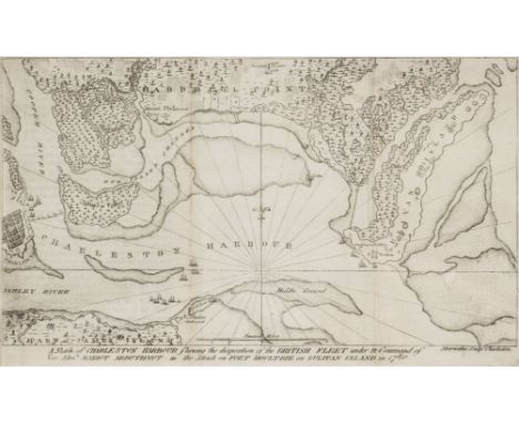
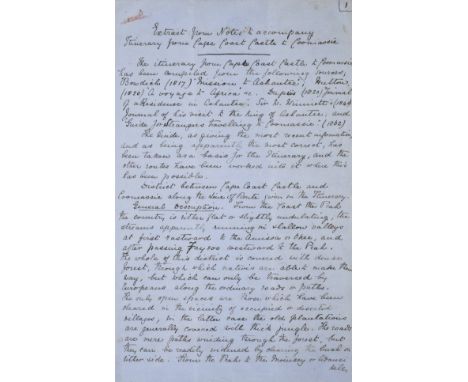
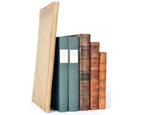
*Wolseley (Garnet Wolseley, 1st Viscount, 1833-1913). Original manuscript briefing notes entitled 'Extract from Notes to accompany Itinerary from Cape Coast Castle to Coomassie', drawn up by Lieutenant John Frederick Maurice, Royal Artillery, Private Secretary to Wolseley during the Ashantee Campaign of 1873-74, and one of the founder members of Wolseley's 'Ashantee Ring', dated 27 September 1873, comprising 11 handwritten pages on six folio sheets of blue official army notepaper, incorporating a pen and ink map of the Ashantee capital, Coomassie, signed with initials 'J.M. Cape C.C.E.' (Cape Coast Castle Expedition), accompanied by a watercolour sketch of the cape coast castle from the seaward side by acting Lieutenant (later Admiral) James Stoddart, Royal Navy (1827-1892), watercolour on card, pencil inscription to verso 'Cape Coast Castle, Admiral Stoddart, as Lieutenant, 1836', 18.5 x 26cm A surprise attack on the British Gold Coast Protectorate by the Ashantee King took place on 22nd January 1873. Months of sporadic violence followed, which the resident British forces - a battalion of the West India Regiment and one hundred Royal Marines - barely managed to contain. A punitive expedition was dispatched from England under the command of Major-General Garnet Wolseley, who embarked for the Gold Coast aboard the SS Ambris with an advance part of thirty-five staff officers, from Liverpool on 12th September 1873. Wolseley and his officers landed at the Gold Coast Castle on 2nd October 1873. This draft plan of campaign was drawn up by Lieutenant Maurice while Wolseley was at sea, being dated just five days prior to their disembarkation at Cape Coast Castle. Arriving, by design, well in advance of the main body of his force, which did not arrive until January 1874, Wolseley had a detailed plan, based on Lieutenant Maurice's comprehensive notes, in place by the time his troops arrived. After citing the various published and written sources used when drawing up the plan of campaign, including Bowdich's Mission to Ashantee (1817), Hutton's A Voyage to Africa (1820), Dupuy's Journal of a Residence in Ashantee (1820), Commander William Winniatt's Journal of his visit to the King of Ashantee (1848) and the Guide for Strangers traveling to Coomassie (1862), the notes provided General Wolseley with a detailed account of the country between the coast and the Ashantee capital, its peoples, towns and villages (with estimates of population), the jungles, rivers and swamps, climate and potential for obtaining supplies during an advance; Maurice details five different potential routes from the coast to Coomassie (7 pages of the text), outlining potential difficulties, whether the land to be crossed might prove friendly or hostile, the total distance covered by each route, along with a copied map of the Ashantee capital, taken from Bowditch, at a scale of 400 paces to the inch, indicating the position of the principal buildings and locations in the city, including Aboosaywe, or place of execution, the palace, temple, etc, and the various types of terrain in the immediate vicinity of the capital; swamp, ground cleared but rocky, yam garden, etc, as a guide to selecting the best route for the final attack. Five routes are proposed: one from the River Prah through Kairokou, Eusaguesu, Abbatea and Biaqua to Coomassie, Maurice noting with regard to this route that as the tribes to the west of Elminia have revolted, this route leaves the left flank of the line of communication so exposed that it would seem madness; a second route from the Cape Coast Castle via Anamaboe, which Maurice describes as being too difficult and dangerous; a third route from Accra to Aguieso across the rivers Birrimo, Auinee and Boosim-Prah, described as having the advantage of starting from Accra, as a base the most healthy place on the coast and well within British territory; a fourth route from Accra, passing to the north of the proposed route 3; and a fifth route to Coomassie via the River Volta, which Maurice notes as only being practicable if the river was navigable when the campaign commenced. Wolseley was able to complete the campaign successfully in only two months, evacuating his troops before the malarial wet season arrived. The plan of campaign that Wolseley put into action was essentially an amalgam of the first two options proposed by Maurice, described respectively as madness and difficult and dangerous, Wolseley overcame the problems these two routes presented by negotiating agreements with the previously hostile tribes on the left flank of his line of attack, and recruiting them to actually assist in the invasion of the Ashantee kingdom that had been previously oppressing them. The problem of passing large numbers of troops through dense jungle along narrow tracks and roads was overcome by splitting his attack into four columns, constructing an advance jumping off point in the interior at Prahsu, approximately fifty miles from Coomassie, from which the main column attacked along the Prahsu - Coomassie road, supported by the three flanking columns, and converging on Coomassie for the final assault. Captain (later Major-General Sir) John Frederick Maurice (1841-1912) obtained material and information from a wide variety sources, including Admiral James Stoddart, from whom he obtained this watercolour showing the location and strategic importance of the Cape Coast Castle, which became the base for operations during the Ashantee campaign. (2)

![SoulŠs (Francois). [Carte itineraire de la marche des troupes de York town a Boston, 1787], uncoloured engraved map on blue p](https://cdn.globalauctionplatform.com/bc31b7f5-f407-4392-997f-a94400dd2197/3021a6c4-4ab6-47ac-c736-e63b62a4dd2f/468x382.jpg)


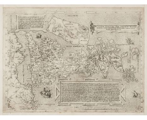
![Lhuyd (Humphrey and Ortelius, Abraham), Cambriae typus auctore Humfredo Lhuydo Denbigiense Cambrobritano, [1595], engraved m](https://cdn.globalauctionplatform.com/bc31b7f5-f407-4392-997f-a94400dd2197/90881010-31de-4d9e-a41c-aab2d70ed396/468x382.jpg)
![*Speed (John), The Kingdome of Great Britaine and Ireland, 1st edition, John Sudbury & George Humble, [1611], hand coloured e](https://cdn.globalauctionplatform.com/bc31b7f5-f407-4392-997f-a94400dd2197/afbc188f-182f-49dc-8777-9723c3df1fe3/468x382.jpg)


![Teesdale, Henry New British Atlas Containing a Complete Set of County Maps...Published by Henry Teesdale & Co., [1829]. Folio](https://cdn.globalauctionplatform.com/db6b26b8-b86f-48f9-a1c6-a92900aa3753/77fc844a-f995-4649-b10e-51eec8354157/468x382.jpg)


![Scottish Geology Milne [Home], David Memoir on the Lothian and Mid-Lothian Coalfields. William Blackwood and Sons., Edinburgh](https://cdn.globalauctionplatform.com/db6b26b8-b86f-48f9-a1c6-a92900aa3753/7ff9923a-9d5a-4924-efd8-82f18de481ff/468x382.jpg)


![Morden, Robert The North Riding of Yorkshire. Sold by Abel Swale et al, [c. 18th c.]. and Darbyshire. Sold by Abel Swale et a](https://cdn.globalauctionplatform.com/db6b26b8-b86f-48f9-a1c6-a92900aa3753/c7c37895-e704-4c7b-f02a-03799d24733f/468x382.jpg)


![Mercator, G.; Jansson, J. Gallicia Legio, et Asturias de Oviedo. Amsterdam, [c.1628]. Sometime hand-coloured. From the Atlas](https://cdn.globalauctionplatform.com/db6b26b8-b86f-48f9-a1c6-a92900aa3753/6f86682a-4a9b-468d-9a89-16426246698a/468x382.jpg)
![[Burke, Edmund]. Broken run of The Annual Register or a View of the History, Politics and Literature for the Years 1758-75,](https://cdn.globalauctionplatform.com/db6b26b8-b86f-48f9-a1c6-a92900aa3753/189be626-adbb-4093-9f61-1b0e89c9886f/468x382.jpg)