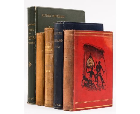

Africa.- Zimbabwe & Zambesi.- Bent (J. Theodore) The Ruined Cities of Mashonaland, first edition, folding map frontispiece, plates and illustrations, 4 maps, 2 folding, scattered faint spotting, bookplate, original pictorial cloth, slight bumping to corners and extremities, [Hosken p.16], 1892 § Blennerhassett (Rose) & Lucy Sleeman. Adventures in Mashonaland, first edition, map frontispiece, bookplate, original pictorial cloth, slight bumping to corners and extremities, [Hosken p.20], 1894 § Bertrand (Alfred) Au Pays des Ba-Rotsi Haut-Zambèze, first edition, portrait frontispiece, vignette title, plates and illustrations, 2 folding maps, previous owner's ink inscription, cracked hinges, original pictorial cloth, gilt, small split to spine head, slight bumping to corners and extremities, Paris, 1898 § Rankin (Daniel J.) The Zambesi Basin and Nyassaland, first edition, publisher's compliments blind-stamp to title, frontispiece, plates, folding map, publisher's advertisements at end, bookplate, ex-Royal Empire Society with label and small stamp to title, original pictorial cloth, slight bumping to corners and extremities, [Hosken p.165], 1893 § Harding (Col. Colin) In Remotest Barotseland, first edition, portrait frontispiece, vignette title, plates and illustrations, folding map at end, one or two neat marginal notes, scattered faint spotting, bookplate, near contemporary calf-backed boards, 1905; 8vo & 4to (5)
We found 109198 price guide item(s) matching your search
There are 109198 lots that match your search criteria. Subscribe now to get instant access to the full price guide service.
Click here to subscribe- List
- Grid
-
109198 item(s)/page
India.- Stein (Sir Marc Aurel) On Alexander's Track to the Indus, first edition, half-title, frontispiece, plates, 2 folding, 2 folding maps at end, occasional faint marginal spotting, bookplate, modern half-crushed morocco, gilt, 1929; On Ancient Central-Asian Tracks, first edition, colour frontispiece, plates, 8 folding, 14 colour, folding map at end, bookplate, modern half-crushed morocco, gilt, 1933, 8vo (2).
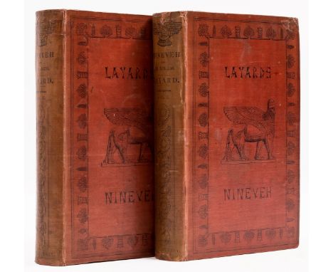
Middle East.- Layard (Austen H.) Nineveh and its Remains, 2 vol., third edition, half-titles, tinted lithograph frontispieces, 24 plates, 6 folding, illustrations, folding map, short tear at edge with neat old repair to verso, previous owner's ink inscription to half-titles, scattered spotting, printed endpapers, bookplate, original decorative cloth, recased, lightly sunned spines, slight bumping to corners and extremities, 8vo, 1849.
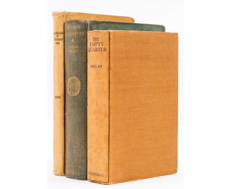
Middle East.- Philby (Harry St. John Bridger) The Empty Quarter, first edition, frontispiece, plates, 3 folding maps, 2 at end, scattered faint spotting, previous owner's ink inscription, bookplate, original cloth, slight bumping to corners and extremities, 1933; Sheba's Daughters, first edition, frontispiece, folding map at end, split to folds, tape repairs to verso, scattered spotting, bookplate, original cloth, light mottling, slight bumping to corners and extremities, 1929 § Dutton (E. A. T.) Lillibullero or The Golden Road, bookplate, original cloth, slight bumping to corners and extremities, Zanzibar, 1947; 8vo (3).
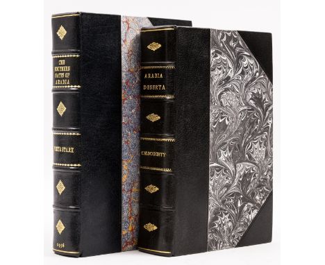
Middle East.- Stark (Freya) The Southern Gates of Arabia, first edition, half-title, title in red and black, plates, folding map at end, bookplate, modern half-morocco, 1936 § Doughty (Charles M.) Travels in Arabia Deserta, half-title, portrait frontispiece, plates, several folding, illustrations, large folding colour map at end, bookplate, advertisement for Hogarth's 'The Life of Charles M. Doughty' loosely inserted, modern half-morocco, 1928; 8vo (2).
Turkey.- Ramsay (Sir W. M.) & Gertrude L. Bell. The Thousand and One Churches, first edition, half-title, plates and plans, some folding, illustrations, ex-library with label, ink-stamps to title and title-verso and occasional blind-stamps, bookplate, later buckram, small faint abrasion mark to spine foot where label removed, 1909 § Bell (Gertrude L.) Amurath to Amurath, second edition, half-title, frontispiece, plates and illustrations, folding colour map at end, marginal tear not affecting image with neat tape repair, previous owner's ink signatures to front free endpaper, bookplate, original decorative cloth, slight bumping to corners and spine extremities, 1924, 8vo (2)⁂ The first is relatively scarce with only one copy currently available on vialibri.
Africa.- Barrow (John) An Account of Travels into the Interior of Southern Africa, 2 vol., first edition, double-page folding map with hand-coloured routes, folding aquatint, 8 folding maps and charts, one or two with faint staining to upper corners, faint off-setting, spotting to first few leaves vol. 1, contemporary calf, rebacked, [Hosken p.11], 4to, 1801-04.

World.- Hakluyt Society.- Travels of Ibn Battuta (The) A.D. 1325-1354, 5 vol., frontispieces, plates, 5 folding maps, vol. 4 & 5 with dust-jackets, 1995-2000; The Prester John of the Indies, 2 vol., frontispieces, plates and illustrations, 2 folding maps, 1 in pocket at end vol. 2, price-clipped dust-jackets, slight creasing to edges, Cambridge, 1961; The Portuguese Expedition to Abyssinia in 1541-1543, frontispiece, plate, folding map in pocket at end, marginal pencil note, sunned spine, abrasion mark to spine foot where label removed, slight bumping to extremities, 1902; The Christian Topography of Cosmas, an Egyptian Monk, 4 folding plate, label of 'Royal United Service Institution' to front pastedown, neat repair to upper hinge, small loss to spine head, neatly repaired, abrasion mark to spine foot where label removed, 1897; bookplate, original cloth, 8vo (9)⁂ Complete sets of the first are relatively uncommon.
World.- Apianus (Petrus) Cosmographia Petri Apiani, per Gemmam Frisium, with a folding variant version of Gemma Frisius' larger cordiform map of the world, after Apianus's map of the world, inserted before title, woodcut title and globe vignette with entire lower half of leaf with loss replaced in pen facsimile, all volvelles with moving parts lacking and replaced with printed facsimile additions, ink manuscript inscriptions to title and others elsewhere, scattered spotting and browning, heavy surface dirt in places with damp-stains, later endpapers with owners ink inscription to front free endpaper, vellum, browned, slightly warped and scuffed, worn, 4to, [Sabin 1756], [Cologne, 1574]; sold not subject to return.Provenance:Gabriel Molina, Madrid (bookplate to front pastedown)A. Garcia-Hernandez (stamp to reverse of title and rear endpaper)

World.- Arrowsmith (Aaron) A New General Atlas... of all the Known Countries in the World, engraved title, index and 53 maps, a few with hand-colouring, each interleaved with tissue, each map sheet approx. 290 x 230 mm (11 1/2 x 9 in), spotting and surface dirt throughout, handling creases, contemporary half calf, spine split with repairs to upper and lower section keeping boards attached, owners ink inscription to front pastedown, bookplate to front free endpaper, publisher's printed label to upper cover, worn, 4to, 1817

World.- Doppelmayr (Johann Gabriel) Basis Geographiae Recentioris Astronomica in qua Situs Locorum Insigniorum Geographici ea Exactitudine, qua Celeberrimi Astronomi Eosdem per Observationes..., double hemisphere world map showing the continents without political divisions, with California as an island, and only the western and northern coastlines of Australia shown, the surrounds are decorated with vignettes of putto with scientific instruments, and with solar events occurring in the sky, engraving with vibrant hand-colouring, on laid paper with indistinct text-based watermark, platemark 490 x 580 mm (19 1/4 x 22 3/4 in), sheet 530 x 615 mm (20 3/4 x 24 1/4 in), central vertical fold, minor handling creases, scattered surface dirt, unframed, Johann Baptist Homann, [circa 1742]

World.- Jaillot (Alexis-Hubert) Mappe-Monde Geo-Hydrographique, ou Description Generale du Globe Terrestre et Aquatique en Deux-Plans-Hemispheres..., large double-hemisphere world map after Nicolas Sanson's world map, showing California as an island, with parts of New Zealand and Australia, with decorative ornament in-between the hemispheres, engraving with hand-colouring, on two sheets joined, total sheet 580 x 940 mm (22 3/4 x 37 in), laid onto support with repaired tears, central vertical fold with splitting, some spotting and browning, unframed, Paris, 1691.

World.- Laurie & Whittle (publishers) A New Chart of the World on Wright's or Mercator's Projection in which are Exhibited all the Parts Hitherto Explored and Discovered with the Tracks of the British Circumnavigators, Byron, Wallis, Carteret and Cook &c., engraved chart with outline hand-colouring, two sheets conjoined, total size approx. 750 x 940 mm (29 1/2 x 37 in), heavy browning and damp-stains, some splitting and small losses to folds, nicks and losses to extremities, unframed, 1808; together with a 3 variant hemisphere world maps for Thomson's atlas, a double hemisphere world map by Jehoshaphat Aspin from 1838, and a good group of 23 terrestrial and celestial hemisphere maps by Louis Brion de la Tour, from 'Atlas Général Méthodique et élémentaire', engravings, some hand-colouring, various sizes, all unframed, 18th and 19th century (28)

World.- Meyer (Joseph) Neuester Universal-Atlas fur Alte & Neue Erdkunde, title, index, and 89 engraved maps with outline hand-colouring, the celestial chart with movable volvelle, each map sheet approx. 255 x 305 mm (10 x 12 in), a few leaves detached, some scattered spotting and surface dirt, hald calf, spine splitting, slightly worn, oblong 4to, [circa 1840].

World.- Northern hemisphere.- Van der Aa (Pieter) Planisphere Terrestre, Suivant les nouvelles Observations des Astronomes, map of the World based on Cassini's important north polar projection, with Greenland attached to mainland North America and California as an island, with much of the Pacific Northwest left blank, with border decorations of the four elements engraved by by G. Van Gouwen, engraving on thick laid paper, sheet 553 x 760 mm (21 3/4 x 29 7/8 in), mounted on conservation support, central vertical fold with repairs to old splits and associated losses, section of loss to lower left margin restored, not affecting the map, some browning and surface dirt, unframed, Leiden, 1713.

World.- Plancius (Petrus) Orbis Terrarum Typus de Integro Multis in Locis Emendatus auctore Petro Plancio, double-hemisphere world map, after Mercator's world map of 1587, and the first map to show Japan as four islands, with the addition of 'Magallanica' to the large southern continent, engraving by Baptista Doetecomus, on laid paper with indistinct watermark, platemark 285 x 510 mm (11 1/4 x 20 in), sheet 365 x 510 mm (14 1/4 x 20 in), Dutch text verso, old vertical folds, some marginal damp-stains, handling creases and surface dirt, unframed, [circa 1590]Literature:Shirley 177 [second state] ⁂ First map to show Japan as four islands.

World.- Santini (Francois) and G.A. Raimondi. Nouvelle Mappe Monde dediee au progres de nos connoissances, double-hemisphere world map, decorative spandrels and border ornaments by Choffard, text below, engraving with some outline hand-colouring, on thick laid paper with watermark of the letter 'R', platemark 490 x 670 mm (19 1/4 x 26 3/8 in), sheet 525 x 755 mm (20 3/4 x 29 3/4 in), minor handling creases, minor spotting, unframed, Venice, Raimondi, [1784]; together with 2 further world maps, including A.J. Johnston's 'Johnston's World on Mercators Projection', and 'The World on Mercator's Projection', both unframed, 19th century (3)
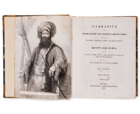
Africa.- Belzoni (Giovanni Battista) Narrative of the Operations and Recent Discoveries ... in Egypt and Nubia, 1 vol. only (of 2, without Atlas), second edition, lithographed portrait frontispiece, 1 engraved plate, 1 large engraved map, scattered spotting, most to first and last few leaves, bookplates, new endpapers, contemporary half-calf, rebacked, rubbed, 4to, 1821.


Atlases.- Kitchin (Thomas) Kitchin's General Atlas, Describing the Whole Universe, title, with 18 maps only (of 40), lacking the maps of America and the World, with only one part (of two) of Ireland, but includes the two part map of 'The East Indies' showing the entirety of India by Thomas Jefferys, engravings on various papers, various sizes, all on stubs, a few loose, some folds with splitting, a few with even toning, scattered surface dirt, handling creases and minor nicks, later marbled boards, very worn with spine splitting, folio, Laurie & Whittle, 1804.

NO RESERVE Africa.- De L'Isle (Guillaume) Carte d'Afrique Dressee pour l'Instruction par Guillaume Delisle, double-page map of Africa, engraving with outline hand-colouring, platemark 490 x 630 mm (19 1/4 x 24 3/4 in), full margins, central vertical fold, faint damp-staining, handling creases, spottting and surface dirt, unframed, 1800; together with Jan Jansson's 'Fezzae et Marocchi Regna Africae', map of Morocco, engraving, on laid paper without watermark, platemark 385 x 500 mm (15 1/8 x 19 3/4 in), full margins, some spotting and surface dirt, handling creases, unframed, [circa 1650]; and Pieter van der Aa's 'Royaumes de Congo et d'Angola', and J.V. Schley's 'Carte de la Coste d'Angola', all unframed, 18th century (4)


Africa.- Ortelius (Abraham) Africae Tabula Nova, detailed map of Africa based upon Gastaldi's 8 sheet wall map and Mercator's world map of 1569, decorated with a strapwork title cartouche, a sea battle in the lower right corner, and sea monsters, engraving with hand-colouring, platemark 375 x 500 mm (14 3/4 x 19 3/4 in), sheet 430 x 560 mm (16 7/8 x 22 in), Latin text verso with page number '4', central vertical fold with expert repairs to lower section, other minor handling creases, light surface dirt and browning, unframed, [Antwerp, circa 1570-1612]Literature:VdB 8
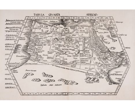
Africa.- Waldseemüller (Martin) Tabula Quarta Africae, Ptolemaic Map of Northern Africa, woodcut, on laid paper with small watermark of a crown, sheet 415 x 570 mm (16 1/4 x 22 1/2 in), central vertical fold with some careful repairs to splitting and minor loss, upper edge with support verso and small repaired nick, unframed, [Strasbourg, circa 1513]. ⁂ Scarce early map of Northern Africa.
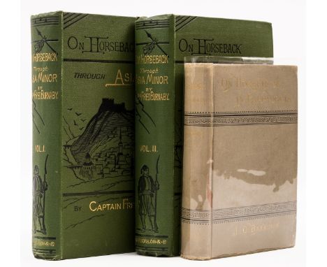
Asia Minor.- Barrows (J. O.) On Horseback in Cappadocia, first American edition, double-page map, full-page illustrations, scattered spotting, new endpapers, original cloth, gilt, slight bumping to spine extremities, Boston, 1884 § Burnaby (Captain Fred) On Horseback Through Asia Minor, 2 vol., fourth edition, half-titles, photographic portrait frontispiece, 3 folding maps, 1 with short marginal tear, original pictorial cloth, gilt, fractional bumping to corners and extremities, ex-library with blind-stamp to lower boards, 1877; 8vo (3).⁂ The first is scarce.

Australia.- Westgarth (William) Victoria, late Australia Felix. or Port Philip District of New South Wales, first edition, presentation inscription "Major Mercer with the author's regards" to endpaper with later gift inscription from the Mercer family below, folding map (short split to one fold), hand-coloured in outline, errata slip, folding table, 8pp. advertisements at end, original pink blind-stamped cloth, slight sunning to spine, slight bumping and fraying to spine ends and corners, occasional fraying to joints, light surface soiling to covers, but a very good example overall, [Ferguson 18415], 8vo, Edinburgh, 1853.

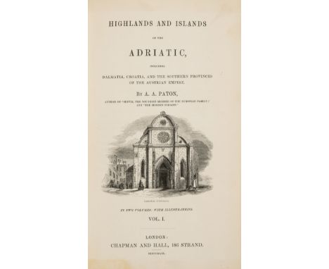
Balkans.- Paton (A. A.) Highlands and Islands of the Adriatic, including Dalmatia, Croatia and the Southern Provinces of the Australian Empire, 2 vol. bound in 1, first edition, tinted lithograph frontispieces, vignette titles, 8 tinted lithographs, double-page plan, folding map, pp.47-48 with short tear in to text neatly repaired, scattered spotting, original blind-stamped cloth, a little rubbed, slight bumping to corners and extremities, 8vo, 1849.

China.- Blaeu (Willem Jansz. and Johannes) China Veteribus Sinarum Regio, map of China, Korea and Japan, with decorative cartouche in the upper right corner, engraving with original hand-colouring on laid paper, platemark 415 x 505 mm (16 1/4 x 19 7/8 in), 505 x 590 mm (19 3/4 x 23 1/4 in), German text verso, minor surface dirt and spotting, unframed, [Amsterdam, circa 1640].

China.- Blaeu (Johannes) Imperii Sinarum Nova Descriptio, map of China, Korea and Japan, published in the Jesuit Martino Martini's 'Atlas Sinensis', the first western atlas of China, engraving with early hand-colouring, on laid paper with watermark of Atlas holding up the heavens, sheet 465 x 600 mm (18 1/4 x 23 1/2 in), trimmed to borderline and expertly inset into paper mount to imitate margins, some small marginal losses restored, otherwise minor spotting and surface dirt, unframed, [Amsterdam, 1655].

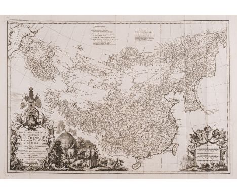
China.- d'Anville (Jean Baptiste Bourguignon) Carte Generale de la Chine Dressée sur les Cartes Particulieres Que l' Empereur Chang-Hi a fait lever sur les lieux.., large map of China, including Hainan and Formosa in the south, and Quantong and parts of the Gobi Desert in the north, engraving with outline hand-colouring, on thick laid paper, sheet 685 x 560 mm (27 x 22 in), horizontal fold, with associated repaired tear to left section, handling creases, spotting and surface dirt, unframed, Paris, 1730.
China.- d'Anville (Jean Baptiste Bourguignon) and Jean Baptiste Du Halde. Carte la plus generale et qui comprend la Chine, la Tartarie chinoise et le Thibet, map of China showing from the Caspian Sea to Sakhalin Island, based on maps prepared for the Kangxi Emperor by Jesuit missionaries for a woodblock Chinese atlas published in 1718 or 1719, engraving on thick laid paper, with watermark of rosary beads, platemark 500 x 710 (19 3/4 x 28 in), sheet 545 x 780 mm (21 1/2 x 30 3/4 in), old folds as issued, some minor handling creases and surface dirt, unframed, Paris, 1734.

NO RESERVE China.- Du Halde (Jean Baptiste) The General History of China. Containing a ... Description of the Empire of China, Chinese-Tartary, Corea and Thibet, 4 vol., third edition, titles in red and black, engraved frontispieces, 14 engraved plates only (of 15), 10 folding, 1 folding map only (of 4), illustrations, worming affecting text and images, partially repaired, each vol. lacking A1 (?blank), previous owner's ink signature to front pastedowns and titles, trimmed affecting page numbers and catch-words, scattered spotting and staining, later calf, a little rubbed, slight bumping to corners and extremities, 8vo, for J. Watts: and sold by B. Dod, 1741.

China.- Grosier (Jean Baptiste) A General Description of China ..., 2 vol., first English edition, half-titles, folding engraved map hand-coloured in outline, 15 engraved plates, 1 folding, occasional faint marginal staining, bookplate, previous owner's ink inscription, contemporary half-calf, rebacked, a little rubbed, 8vo, 1788.⁂ Provenance: Ink inscription of Percy Cradock (1923-2010), who served as British Ambassador to China between 1978 and 1983.
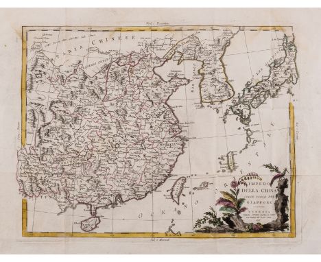
China, Korea, and Japan.- Zatta (Antonio) Impero della China Colle Isole del Giappone, engraved map with outline hand-colouring, 330 x 420 mm (13 x 16 1/2 in), good margins, old folds, repaired tear to left margin, other minor marginal nicks and surface dirt, unframed, Venice, 1795; together with another double-page map of China by Adam and Charles Black, lithograph printed in colours, 450 x 600 mm (17 3/4 x 23 1/2 in), unframed, 19th century (2)
China.- Le Comte (Louis) Memoirs and Observations ... Made in a late Journey Through the Empire of China, third edition, engraved portrait frontispiece, 3 engraved plates, 2 folding, 1 folding table, 1 folding engraved map, small marginal tear, old repair to verso, engraved illustrations, scattered spotting and staining, trimmed occasionally affecting signature of catch-word, previous owner's ink signature to title, lacking final free endpaper, near contemporary ink signature to front free endpaper, later panelled calf, rubbed, small loss to lower board, bumping to corners and extremities, [Wing L833], 8vo, for Benjamin Tooke, 1699.
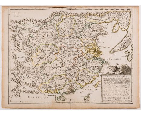
China.- Sanson (Nicolas) and Pierre Mariette. La Chine Royaume, a French map of China, based on an indigenous Chinese map copied by Jesuit Matteo Ricci, and brought back to Rome in 1590 by his fellow Jesuit, Michele Ruggieri, engraving with original outline hand-colouring, on laid paper with watermark of a compass, platemark 420 x 535 mm (16 1/2 x 21 in), sheet 435 x 580 mm (17 1/8 x 22 3/4 in), minor handling creases, some spotting and browning, mainly marginal, unframed, Paris, 1656.
![China.- [Scarth (John)] Twelve Years in China. The People, the Rebels, and the Mandarins, second thousand, half-title, additi](https://cdn.globalauctionplatform.com/bfa3d355-fbd9-45ca-96ec-af5700fbb02d/da1a2bbd-ba6c-43dd-b71c-af5700fcdb82/468x382.jpg)
China.- [Scarth (John)] Twelve Years in China. The People, the Rebels, and the Mandarins, second thousand, half-title, additional vignette title, 8 hand-coloured plates, 3 tinted lithographs, illustrations, folding map at end, 2 short tears with tape repairs to verso, scattered spotting, bookplates, original pictorial cloth, rebacked retaining original backstrip, 8vo, Edinburgh, 1860.⁂ Provenance: Bookplate of Henri Cordier (1849-1925), French linguist, historian and Orientalist. He was president of the Société de Géographie in Paris. Bookplate of Keith G. Stevens.

China.- Seutter (Matthäus) Opulentissimum Sinarum Imperium, map of China with large decorative title cartouche surmounted with figures in the lower right corner, engraving with early hand-colouring, cartouches uncoloured, on thick laid paper without watermark, platemark 505 x 585 mm (19 7/8 x 23 in), sheet 535 x 605 mm (21 x 23 3/4 in), central vertical fold, minor surface dirt, unframed, [Augsburg, circa 1740s].


Greece.- Speed (John) Greece, engraved map with hand-colouring, on laid paper, platemark sheet 395 x 510 mm (15 1/2 x 20 1/8 in), under glass, central vertical fold with very minor repairs, two small repairs to upper right, handling creases, some surface dirt and minor surface toning, framed, Bassett & Chiswell, [circa 1676]
Holy Land.- Wilkinson (Robert) Wilkinson's Atlas Classica, engraved vignette title, index, 46 engraved maps and 7 tables, all with hand-colouring, 7 double-page maps, and one folding table, all mounted on stubs, some beginning to come away from spine, damp-stain to title and first map, otherwise minor spotting and light offsetting in places, half calf, rubbed and scuffed, 4to, 1820.

India.- Dury (Andrew) A Map of the Provinces of Delhi, Agrah, Oude, and Ellahabad, comprehending the Countries lying between Delhi, and the Bengal-Provinces, Surveyed by James Rennell, large two-sheet map of Delhi and Bengal, illustrating the Ganges River from the foothills of the Himalayas, to just outside Patna, engravings with outline hand-colouring, four sheets joined as two, each sheet approx 540 x 1050 mm (21 1/4 x 41 1/4 in), folds as issued, handling creases, some offsetting, surface dirt, and minor nicks, unframed, Laurie & Whittle, 1794.

India.- East Indies.- Laurie (Richard Holmes, publisher) A New General Map of the East Indies... and the Dominions of the English East India Company, engraved map with full hand-colouring, on thick wove paper without watermark, platemark 595 x 730 mm (23 1/2 x 28 3/4 in), good margins but with some losses and tears, a few just into the plate, surface dirt and browning, handling creases, unframed, 1829; together with a good group of 16 other maps of the East Indies, by publishers and cartographers that include Vaugondy, J. Bartholomew, Thomson and others, various sizes, all unframed, mainly 18th and 19th century (17)


India.- Laurie & Whittle (publishers) A New Map of the Jaghir Lands, on the Coast of Coromandel, The Territory Belonging To The East India Company Round Madras From An Actual Survey In The Possession Of The Company, detailed map of the coastal region of India centred on Madras and Fort St. George (Chennai), extending north to Erikans Lake (Pulicat Lake) and south to Cheeyer Tank and Allumparva (Cheyyur) engraving with some outline hand-colouring, on wove paper, sheet 730 x 540 mm (28 3/4 x 21 1/4 in), central horizontal fold as issued, some light offsetting, minor surface dirt, unframed, 1794 § India.- Dury (Andrew) An Actual Survey of the Provinces of Bengal, Bahar &c., By Major James Rennell [...] published from a drawing by A. Dury, large two-sheet wall map of Bengal, illustrating the course of the Ganges River from Varanasi (Benares) eastward to the Ganges Delta and the Bay of Bengal, including Varanasi (Benares), Dacca (Dahka, Bengladesh), and Patna among many other important Indian cities, with the foothills of the Himalayan Mountains and the border with Bhutan to the north, engravings with outline hand-colouring, four sheets joined as two, each sheet approx. 540 x 1480 mm (21 1/4 x 58 1/4 in), folds as issued, some handling creases, surface dirt and old stains, nicks and tears, unframed, Laurie & Whittle, 1794 (2)
India.- Laurie & Whittle (publishers) A New Map of Hindoostan from the latest authorites made by Major James Rennell, Surveyor General to the Hble. East India Company, of the Bengal provinces and of the Countries lying between them and Dehly..., large engraved map with outline colouring, presented in two horizontal sections, each section approx. 610 x 1400 mm (24 x 55 1/8 in), old folds, some splitting and loss associated to folds, heaving spotting and browning, handling creases, nicks and tears, unframed, 1794; together with a good group of maps of India, including 'A Map of the Northern Part of Hindoostan or A Geographical Survey of the Provinces of Bengal, Bahar, Awd, Ellahabad, Agra, and Dehli', 1794, with some losses and tears to map, and with 4 others by Thomson, Kitchin, and another, various sizes, unframed, 18th and 19th century (6)
India.- Müller (Dr. Johannes) Beschreibung der Insel Java, hand-coloured lithograph frontispiece, 9 tinted lithographs, 7 hand-coloured lithographs, 1 folding engraved map, tissue-guards, scattered spotting, bookplate, original cloth, gilt, slight bumping to corners and extremities, 8vo, Berlin, 1860.

India.- Robertson (William) An historical disquisition concerning the knowledge which the ancients had of India, second edition, 2 folding engraved maps, light damp-staining to lower edge (including 2nd map), light browning, contemporary tree calf with red morocco label to spine, joints cracked but firm, a little rubbed, 8vo, for A. Strahan et al., 1794.⁂ Includes trading before discovery of the passage around the Cape of Good Hope.

Low Countries.- Leo Belgicus.- Famianus Strada Verduytscht Door Guilliam Van Aelst, miniature version of the Leo Belgicus, based on the original 1538 Aitsinger form with the lion standing facing right with the right paw raised and holding a shield, engraving with full hand-colouring, sheet 150 x 95 mm (5 3/4 x 3 3/4 in), on mount support with margins made-up, small losses and nicks into the map itself, restored, unframed, [circa 1645]

Middle East.- Anet (Claude) Through Persia in a Motor-Car, first edition, frontispiece, plates, spotting, original pictorial cloth, gilt, slight bumping to corners and extremities, small stain to spine foot, 1907 § Jackson (A. V. Williams) From Constantinople to the Home of Omar Khayyam, frontispiece, plates and illustrations, folding map, publisher's advertisements at end, ex-library with blind-stamp to title, original pictorial cloth, slight bumping to corners and extremities, New York, 1911; 8vo (2).
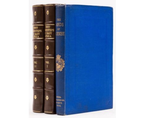
Africa.- Burton (Sir Richard Francis, translator) The Lands of Cazembe. Lacerda's Journey to Cazembe in 1798, first edition, folding map frontispiece, bookplate, original cloth, slight bumping to corners and spine extremities, 1873; First Footsteps in East Africa or, an Exploration of Harar, 2 vol. "Memorial edition", half-titles, colour lithograph frontispieces, plates and illustrations, 2 maps, previous owner's ink signatures to half-titles, spotting to first and last few leaves, bookplate, modern morocco-backed boards, 1894, 8vo (3).

Middle East.- U.S. Geological Survey (Saudi Arabian Project) Topographic Map of the Arabian Peninsula, double-sided information booklet, with 2 maps of the Arabian Peninsula, one with text exclusively in Arabic, colour print, sheet 470 x 850 mm (18 1/2 x 33 1/2 in), old folds as issued, minor surface dirt, unframed, 1972.

Mountaineering.- Conway (Sir William Martin) Climbing and Exploration in the Karakoram-Himalayas, first edition, 1 vol. only (of 2), frontispiece, illustrations, folding map, scattered spotting, contemporary half-morocco, a little rubbed, slight bumping to corners and extremities, 1894.⁂ Without the later, and scarce, second supplementary volume.

Polar.- Shackleton (Ernest H.) The Heart of the Antarctic, popular edition, folding map, covers stained at extremities, 1911 § Johansen (Hjalmar) With Nansen in the North, ex-library with ink stamp to head of contents leaf, gutters cracked and contents shaken, upper hinge cracked, 1899 § Fuchs (Sir Vivian) and Sir Edmund Hillary. The Crossing of Antarctica, dust-jacket, price-clipped, light scattered spotting, some chipping to extremities, 1958, plates or illustrations, all but last with occasional light spotting, original cloth, rubbed, spines sunned; and others polar exploration, v.s. (c.35)

Sicily.- Smyth (Capt. William Henry) Memoir...of Sicily and its Islands, first edition, lacking half-title, with folding engraved map, 16 fine aquatint views on 13 plates by William Daniell, plate 6 trimmed at fore-edge, affecting imprint but not image, offsetting, very occasional spotting, ink stamp of King's Inn Library Dublin to verso of final leaf, later half calf over marbled boards, spine gilt, rubbed, [Abbey Travel, 263], 4to, 1824.

NO RESERVE South America.- Argentina & Uruguay.- Arrowsmith (Aaron) A map of part of the Viceroyalty of Buenos Ayres, engraved map with hand-colouring, 990 x 550 mm (39 x 21 3/4 in), dissected and mounted on linen, light blue silk edges, minor spotting and browning, folding into marbled slipcase, 4to, 1806.

South America.- Sayer (Robert) A Map of South America Containing Tierra-Firma, Guayana, New Granada Amazonia, Brasil, Peru, Paraguay, Chaco, Tucuman, Chili and Patagonia. From Mr. d'Anville, large map with an inset plan of the Falkland's Islands in the upper right corner, descriptive text in the lower left corner, and an elegant rococo-style cartouche in the lower right corner, engraving with outline hand-colouring, on four sheets joined in two horizontal sections, each section approx. 550 x 1230 mm (21 3/4 x 48 1/2 in), folds and handling creases, some minor splitting and small nicks and tears, scattered surface dirt, unframed, 1775; together with Delarochette D'Arcy's two-part map 'Colombia Prima or South America Drawn from the Large Map in Eight Sheets', published by Faden in 1811, and a duplicate slightly damaged copy of Sayer's map but published by Laurie & Whittle, and 2 other double-page maps of the the North Atlantic, various sizes, all unframed, 18th and 19th century (5 maps in 8 sections)

Switzerland.- Beattie (William) Switzerland. Illustrated in a Series of Views Taken Expressly for this Work, 2 vol., additional engraved titles, 106 steel-engraved plates by W. H. Bartlett, folding map, tissue-guards, bookplates of ?Thomas Kelly and Michael Matantos, slight damp-staining to fore-edge of some plates, not affecting engravings, tissue-guards with offsetting from plates, map with some creasing and short tear at inner margin, very occasional spotting, handsome contemporary maroon straight-grain morocco, gilt, lightly rubbed, g.e., 1836; and others travel, most Switzerland related, v.s. (17)
-
109198 item(s)/page