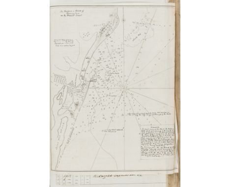
![SMYTH, William (1800-77) & Frederick LOWE (1811-47). Narrative of a Journey from Lima to Para [sic], Across the Andes and](https://cdn.globalauctionplatform.com/a3276cf8-db78-46ec-8c8b-ad5900c80e7d/44d06990-9b8c-4a80-8afb-ad5900d8520d/468x382.jpg)

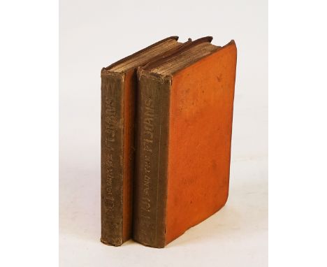
SMYTH, William (1800-77) & Frederick LOWE (1811-47). Narrative of a Journey from Lima to Para [sic], Across the Andes and Down the Amazon.SMYTH, William (1800-77) and Frederick LOWE (1811-47). Narrative of a Journey from Lima to Para [sic], Across the Andes and Down the Amazon: Undertaken with a View of Ascertaining the Practicability of a Navigable Communication with the Atlantic, by the Rivers Pachitea, Ucayali, and Amazon. London: John Murray, 1836. 8vo (225 x 140mm). Lithographed frontispiece, wood-engraved vignette on title, 10 lithographed and wood-engraved plates, folding engraved “Plan of the Rivers Ucayali and Amazon”, 14-pages of publisher’s advertisements at the end (plates and map quite heavily stained and browned with some offsetting onto text leaves, some mainly marginal staining to text). Modern half calf gilt, new endpapers. Provenance: from the Collection of Lt. Cdr. Andrew David (bookplate). FIRST EDITION.
We found 109198 price guide item(s) matching your search
There are 109198 lots that match your search criteria. Subscribe now to get instant access to the full price guide service.
Click here to subscribe- List
- Grid
-
109198 item(s)/page
WILLIAMS, Thomas (1815-91). Fiji and the Fijians.WILLIAMS, Thomas (1815-91). Fiji and the Fijians … Edited by George Stringer Rowe. London: Alexander Heylin, 1858. 2 volumes, 8vo (185 x 120mm). Half title in vol. II, folding engraved map, 12 plates, 3 of which coloured, one-page of publisher’s advertisements at the end of vol. II (plates generally spotted, some light spotting and staining to text). Original peach cloth decorated in blind (spines discoloured, inner hinges weak or broken, stained). Provenance: Henry Hannen (armorial label); from the Collection of Lt. Cdr. Andrew David (bookplate). FIRST EDITION. Abbey Travel 603; Hill p. 1885. (2)

TOMASI DI LAMPEDUSA GIUSEPPE: (1896-1957) Italian Writer, the last Prince of Lampedusa. Rare signed and inscribed book by Lampedusa, being a 4to paperback edition of the book En Sicile by Gabriel Fauré, in French. Signed and inscribed in Italian by Tomasi di Lampedusa to the title page `To my very dear Guido, twenty years have passed, but always with the same affection, Giuseppe´, also dated 21st July 1951. The 200 pages edition, published by B. Arthaud in 1951, numbered 505, includes 181 gravures showing images of Sicily. s, 1917. Lampedusa dedicates the book to his close friend Guido Lajolo, with whom he served in the same regiment during World War I. The book includes a separate map of Sicily. Overall age wear with foxing stains to the covers. Some age toning to the edges of the pages. G
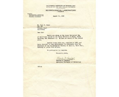
RICHTER CHARLES F.: (1900-1985) American Seismologist & Physicist, creator of the Richter magnitude scale. A rare T.L.S., Charles F. Richter, one page, 4to, Pasadena, California, 30th August 1948, to Paul C. Jones, on the printed stationery of the Seismological Laboratory at the California Institute of Technology. Richter writes, in part, 'Faults are shown on the large Geological Map of California issued by the State Division of Mines…..Another large scale map, compiled in 1922, and hence obsolete in some particulars, is obtainable from the Secretary of the Seismological Society of America…..' Accompanied by the original envelope. One extremely small, minor tear to the left edge of a fold, otherwise VG

SIKORSKI WLADYSLAW: (1881-1943) Polish Lieutenant General of World War II, Prime Minister of Poland 1922-23, 1939-43. An unusual 4to sheet of feint graph paper with various neat and attractive ink annotations commemorating Sikorski, and featuring a montage incorporating a magazine image of the Lieutenant General in a head and shoulders pose wearing his uniform and a map of Poland with the caption Long Live Poland. At the base of the map, in the centre of the page, Sikorski has signed his name in bold blue fountain pen ink, adding the words and date Prime Min. of Poland, London, 26.IX.42 in his hand beneath. An attractive presentation. VG


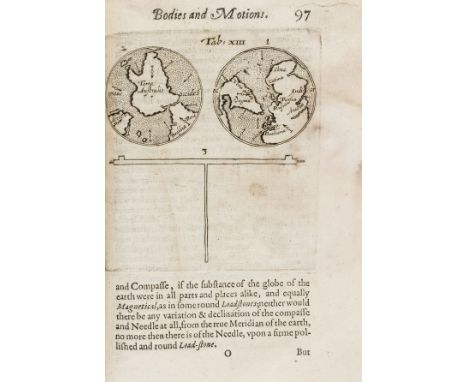
Ridley (Mark) A Short Treatise of Magneticall Bodies and Motions, first edition, second issue with X3 cancelled and containing errata, with first and last blanks, engraved architectural title by Elstrack showing planets and scientific instruments, engraved portrait on a4v, woodcut initials, head-pieces and printer's device at end, 21 engraved and one woodcut diagrams and illustrations, some full-page, one with volvelle (pasted down), damp-stained throughout with purple mildew but stabilised and restored, a few minor tears and repairs (mostly marginal), resewn and recased in old vellum wrapper (part of a contemporary manuscript indenture), also stained, [Honeyman VI 2649; Sabin 71297; STC 21045.5], small 4to, Nicholas Okes, 1613.⁂ An important work in the history of experimental science in England, and the most important work on magnetism after William Gilbert's De magnete. "Ridley gives directions for carrying out experiments on the lodestone, magnet, and terrella. He includes numerous engravings and descriptions of his improved instruments for determining the declination of the magnetic needle and for making use of the inclinatory needle for finding position at sea" (ODNB). There is also a map showing New England, Virginia, and Terra Australis.
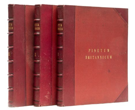
Arboriculture.- Ravenscroft (Edward) The Pinetum Britannicum. A Descriptive Account of Hardy Coniferous Trees, 3 vol., first edition, 48 hand-coloured lithographed plates, 4 mounted albumen prints, 1 engraved map, errata slip, foxing, almost exclusively affecting the text but not plates, contemporary red half morocco, covers lightly stained, a little rubbed, folio, [Nissen BBI 1588], 1884.⁂ This stunningly illustrated work was the result of over twenty years of collaboration and research. The tree portraits in colour are predominantly from the original drawings of William Richardson, those of cones and leaves by Dr Greville and James and Robert Black, and the characteristic sketches of the Deodar Cedars in vol. 3 were captured 'in the field' by Lady Canning during her time in India. The extensive woodcut illustrations throughout the text were also executed by multiple hands; Andrew Murray, James M'Nab, Dr Greville and Dr Maxwell T Masters. Meanwhile, leading conifer specialists of the day, from institutions such as the British Museum, Royal Horticultural Society and Royal Botanical Gardens, as well as individual professors from Florence, Berlin and Paris, and several private experts, all contributed to enhance the publication. On its commencement in 1863, the project received immediate royal support; Queen Victoria requested the work be dedicated to the memory of the recently deceased Prince Albert and provided photographs of two specimens at Osborne House for inclusion, while Emperor Napoleon III secured thirty copies for distribution among French schools of Forestry and Agriculture. Considered one of the great British works on coniferae, the Pinetum Britannicum is a testament to the nineteenth century fascination with natural history and fashion for classifying and cataloguing, and remains unmatched in scope and quality.
![Ptolomaeus (Claudius) Geographiae libri octo, edited by Gerard Mercator, second edition, collation: []2 A-L6, M4, (?)4, A-L2,](https://cdn.globalauctionplatform.com/65d8a6eb-dfaf-49c0-9249-ad4e00f63bf4/ec857183-34de-490b-8325-ad4e01092703/468x382.jpg)
Ptolomaeus (Claudius) Geographiae libri octo, edited by Gerard Mercator, second edition, collation: []2 A-L6, M4, (?)4, A-L2, K2, M-O2, N-Z2, Aa-Bb2, a-b6, c4 (lacking final blank c4), engraved title and 28 engraved maps, all but Egypt double-page, but that of Egypt bound horizontally and thus appearing double-page and smaller, woodcut illustrations, decorations and initials, title with marginal soiling, last map with marginal defect, occasional minor soiling, modern calf, folio, Cologne, Godfried von Kempen, 1584.⁂ The second edition of Mercator's version of Ptolemy, which first appeared in 1576. An important 16th century work, representing Mercator's life-time fascination with Ptolemy and, more broadly, the Renaissance's continued negotiation with the classical past. In order to produce this book, Mercator edited and revisited Ptolemy's Geography, which had been rediscovered in a Greek version in the 14th century and then translated into Latin. Though Ptolemy gave detailed instructions and coordinates in the work as to how maps should be prepared, none are known from classical example. Mercator therefore went through the Latin text carefully, trying to ensure that he obtained the best and truest possible version and drew up the maps from it according to Ptolemy's specifications. The result is this important and attractive work.Literature: VD 16 P 5219
Royal Navy.- Malcolm (George John, Rear-Admiral, 1830-84) Log of the Proceedings of H.M.S... Inconstant... Curacoa... Firebrand..., autograph manuscript, titles and c. 380pp., numerous monochrome wash watercolour slips of coasts and pen and ink maps (including a map of Pernambuco, Brazil), slightly browned, original calf, repaired, folio, 1842-46.⁂ Places visited include: Spain (Tarifa), Straits of Gibraltar, Funchal (Madeira), west coast of Africa, Brazil (Pernambuco), Uruguay ("Plan of the Harbour of Monte-Video") and Argentina (Buenos Ayres Mole").Malcolm was the eldest son of Sir Charles Malcolm (1782-1851), naval officer. He followed in his father's footsteps, serving in the Royal Navy for his entire career and becoming Rear Admiral in 1882. His long naval career took him to North and South America, the West Indies, the Baltic, the English Channel, Egypt, and the East Coast of Africa. After he retired from active service in 1873, he entered the Turkish services as Pasha and was employed at Constantinople as Director General of the Abolition of the Slave Trade and Judge of the Slave Courts.
![Bible, English.- [The Holy Bible, Conteyning the Old Testament, and the New: Newly translated out of the Originall Toungues],](https://cdn.globalauctionplatform.com/65d8a6eb-dfaf-49c0-9249-ad4e00f63bf4/bb5ed892-d7b7-4782-9ec3-ad4e01097a62/468x382.jpg)
Bible, English.- [The Holy Bible, Conteyning the Old Testament, and the New: Newly translated out of the Originall Toungues], woodcut illustrations, initials and head- and tail-pieces, double page map, double column in blackletter 72 lines, Kalendar in red and black, lacking general title but with New Testament title within woodcut border, lacking 6 initial ff. (all before B2, and B4) and final 4ff., some spotting and staining throughout, initial and final leaves heavily creased or defective at margins, several loose, contemporary boards, all leather missing, binding stitching largely present, corners worn, [STC 2226, Herbert 322], [Robert Barker], folio, [1613].⁂ An example of the 'She-Bible' version of the King James Bible, distinguishable from the other folio version of 1613 by its smaller type in 72 lines per column. The She-Bible nomenclature stems from the typographical difference in Ruth 3:15 between early printings of the King James Bible, in some the verse reading 'and she went into the city', while in others it is 'he' who went into the city, known as the 'He-Bibles'. This discrepancy, being the most famous of several such examples, has sparked comment ever since. The desired rapidity and quantity of the print roll out of the King James Bible led Barker, whose family had previously been granted monopoly of royal authorised bible production by Elizabeth I, to subcontract printing out to two further publishing houses, soon resulting in dispute and fervent competition. Thus, it has often been assumed that the She-Bibles are the result of a 'correction' by a typesetter, compositor or proof-reader at some point during the printing process in one or other of the presses; 'she' seems to make more sense in the narrative flow and subsequently became the dominant translation. Such interpretation supports the view that the editio princeps is indeed the He-Bible, but not necessarily as is often consequently thought, because the male pronoun is an original error. Considering the biblical text of Ruth 3:15 in its ancient languages is also obscure since Hebrew and Syriac manuscripts, the Greek Septuagint and Latin Vulgate offer alternative translations. The 40 or so biblical scholars responsible for the King James Old Testament, however, based their efforts on the Masoretic Hebrew texts (the canonical Hebrew as established c.1000AD), which provide the strongest support for the male 'he' translation. Thus the He and She-Bible phenomenon offers scholars of biblical history and book production a continuing historical mystery, touching as it does upon unanswerable questions over the complex material production process of the King James Bible, as well as upon an ancient query of translation.

Bible, English.- The Bible: Translated according to the Hebrew..., woodcut general and New Testament titles, woodcut illustrations, initials and head- and tail-pieces, double column in blackletter, lacking 2M8, 2N1 upper corner defective with loss of some text, 2N5 and 2R4 with marginal tears but no loss of text, a few manuscript prayer annotations, [STC 2241, D&M 340], Robert Barker, 1615 issued with R.F.H, Two profitable and fruitful Concordances, double-page map, Robert Barker, 1615 bound after The Book of Common Prayer, title a little creased, heavily trimmed, affecting headlines and side notes, [Wing B3612], Robert Barker, 1641 bound with The Whole Book of Psalms, worming with slight loss of text, [Wing B2452A], for the Company of Stationers, 1653, some light foxing, soiling and staining throughout, contemporary calf, rebacked with original spine laid down, covers and extremities worn, 4to.
Africa.- Hoskins (G. A.) Travels in Ethiopia, above the Second Cataract of the Nile, first edition, folding engraved map, 53 lithographed plates, 2 hand-coloured, 4 chromolithographed, several folding or double-page, wood-engraved illustrations, small stain to frontispiece and title, map lightly browned and torn & repaired at folds, Ricardo A.Caminos copy with his small ink stamps to dedication, modern morocco-backed buckram by Sangorski & Sutcliffe, spine faded, 4to, 1835.⁂ Ricardo A.Caminos (c.1916-92), Argentine Egyptologist who worked particularly on epigraphy and palaeography.
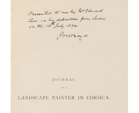
Mediterranean.- Lear (Edward) Journal of a Landscape Painter in Corsica, first edition, presentation copy from the author inscribed "Presented to me by Mr. Edward Lear on his departure from India on the 16th July 1874. J.M.Boyd" on half-title, 40 wood-engraved plates, wood-engraved map and illustrations, occasional spotting, modern black morocco, tan calf label, large 8vo, 1870.⁂ Probably Lieutenant Colonel J.M.Boyd, who served in Abyssinia and the Second Anglo-Afghan War in 1880, taking part in the march from Kabul to Kandahar under General Roberts in August 1880. He was also an accomplished amateur watercolourist which would explain the gift from Lear.
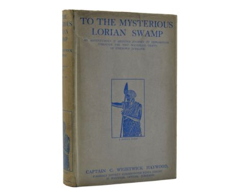
*** Please note the description of this lot has changed.Africa.- Haywood (Capt. C. Wightwick) To the Mysterious Lorian Swamp, first edition, photographic frontispiece and 15 plates, folding map, 12pp. advertisements, original pictorial cloth, gilt, dust-jacket, light toning to spine, a few short repaired tears to head and foot with some light creasing, a very good example overall, 1927.⁂ Rare in the dust-jacket. Sporting adventure in Jubaland, now Somalia, in which the author killed a rhino with an automatic pistol when it charged at him as he was taking a photograph. "[I]t is not the sort of effort I care to repeat...".
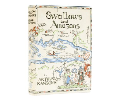
Ransome (Arthur) Swallows and Amazons, first edition, illustrations and map endpapers by Stephen Spurrier, publisher's Arthur Ransom book list loosely inserted, light browning to endpapers, neat repair to foot of front pastedown, original cloth, very light sunning to spine, small patch of discolouration to foot of upper cover, dust-jacket priced at 7s. 6d., very light toning to spine, small chip to head of upper joint, small nick for foot of upper panel, light rubbing to extremities but a bright, near-fine example overall, preserved in custom drop-back box, 8vo, 1930.⁂ Ransom's children's classic, the first instalment in the Swallows and Amazons series and rare in such superb condition.
Europe.- Craven (Elizabeth) A Journey through the Crimea to Constantinople, 6 engraved plates, 1 folding, large folding map, short marginal tear with expert repair, faint damp-stain to last few leaves, bookplate to title verso, occasional faint spotting, contemporary half-calf, a little rubbed, 4to, 1789.
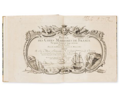
France.- Le Rouge (George Louis) Recueil des Cotes Maritimes de France, first edition, double-page engraved pictorial title, folding key map and 50 double-page coastal maps, some damp-staining and mottling, mostly to corners, later calf-backed marbled boards with vellum corners, [Phillips Atlases 5998; Tooley p.44], 4to, Paris, 1757.⁂ Scarce atlas of French coastal charts by Le Rouge who, according to Tooley, "specialized more on atlases of plans and fortifications. He was educated as a military engineer." This copy has a contemporary ownership inscription of "E.P. Sole" (or possibly E.S. Pole) on title and recto of key map; beneath the latter, in another contemporary hand "found at Cancale on our march to attack St. Malos. 1758". This refers to the raid on St. Malo in June 1758 when an amphibious British naval expedition, under the command of Admiral Howe, landed at Cancale, about 12 miles east of St. Malo in Brittany. Whilst St Malo itself was not attacked, as had been planned, many French privateers and other ships were destroyed before the force withdrew about one week later.
Netherlands.- Bruin (C.) De Zegepraalende Vecht, vertoonende verscheidene Gesichten van Lustplaatsen, Heeren Huysen en Dorpen ..., first edition, additional engraved title, engraved map, 102 engraved plates on 51 sheets, Amsterdam, Nicolaus Visscher, 1719, bound with, Leth (Hendrik de) Het Zegenpralend Kennemerland ..., 2 additional engraved titles (1 misbound), folding engraved map, 100 plates on 50 sheets, Amsterdam, Andries en Hendrik de Leth, [c.1729], together 2 works bound as 1, scattered faint spotting, later panelled calf, gilt, folio.
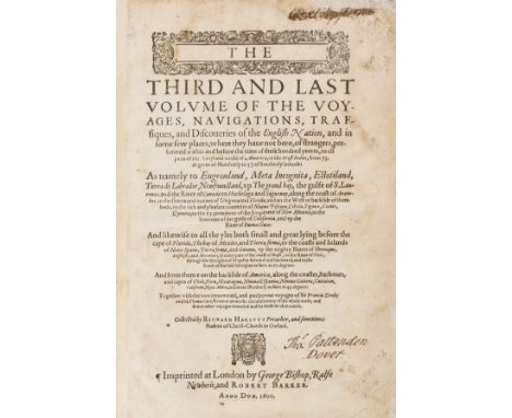
Voyages.- Hakluyt (Richard) The Principal Navigations, Voiages, Traffiques and Dicoveries of the English Nation, made by Sea or overland..., 3 vol. in 2, second edition, black letter, woodcut title ornaments, head-pieces and initials, lacking title to vol.1 (supplied in facsimile and with old photograph loosely inserted) and the folding engraved map (as usual), also lacking final 10ff. of vol.1 including the suppressed leaves on the conquest of Cadiz pp.607-619 and final 12ff. of vol.3, title of vol.2 defective at fore-margin but no loss to text (repaired), title to vol.3 with contemporary ink signature "Thos. Pattenden Dover" and another crossed out at head, some worming (mostly marginal but occasionally affecting text), edges frayed with several leaves repaired at fore-edge, water-staining to vol.3, vol.1 & 2 bound together in old red morocco, rubbed, a few small gouges, rebacked preserving old spine, vol.3 modern red morocco, spine faded, [Hill 743; Pforzheimer 443; Sabin 29596-29598; STC 12626], folio, by George Bishop, Ralph Newberie, and Robert Barker, 1598-1600; sold not subject to return⁂ Monumental record of Elizabethan exploration and greatly expanded from the first edition of 1589; vol.3 is entirely devoted to the Americas.

Geology.- Mantell (Gideon) The Fossils of the South Downs; or Illustrations of the Geology of Sussex, first edition, half-title, 42 aquatint and engraved plates, 2 folding, 4 hand-coloured, illustrations, hand-coloured map, list of subscriber's, occasional spotting, previous owner's ink signature, near contemporary half-calf, a little rubbed, 4to, Lupton Relfe, 1822.


17th/18th and 19th century maps of the Isle of Wight - including Vincenzo Maria Coronelli Isola di Wight circa 1695; Thomas Osborne Correct Map of the Isle of Wight circa 1748 (framed and glazed); John Rocque map of the Isle of Wight circa 1750 hand-coloured and Robert Morden 'The Smaller Islands in the British Ocean' including Isle of Wight, Alderney, Jersey and Garnsey of Sarina and one other book print of the Isle of Wight; J & L Walker steel engraving depicting Southampton and the Isle of Wight circa 1835; J. Wallis isle of Wight miniature map of Isle of Wight circa 1810; Isle of Wight miniature card map pre 1925; J. Cary Isle of Wight circa 1800; attributed to Thomas Hutchinson, 1748 first edition Geographia Magnae Britanniae with ex-library blind stamps to top two corners; W. Jeffery's map of the Isle of Wight circa 1812; M.A Leigh map of the Isle of Wight circa 1825; Speed J miniature of the Isle of Wight circa 1662; map of English islands Mercator circa 1613 with French text on the reverse; Thomas Kitchin New Map of the Isle of Wight for the London Magazine circa 1764; Herman Moll map of the Isle of Wight Scilly Islands and Holy Island Fairn Islands and Staiples circa 1724.
Quantity of antique maps of Hampshire or Isle of Wight. Listed as follows: J.Cary Berkshire and Hampshire approx 26 x 21 cms, John Cary Westmoreland map from the New and Correct English Atlas 1787, Alexander Hogg 'New of Map of Yorkshire', J. Robins & Co map of Hampshire, Wagner & Debes Southampton Environs 1906, J Owen Bowen Hampshire, G.W Bacon & Ltd Isle of Wight approx 14 x 9 cms, Roads from Alresford to Poole by J.Owen and E.Bowen from the 1720 first edition of Britannia Depicta, one of the first true pocket-sized road books, Map of the Channel Islands by Owen and Bowen from Britannia Depicta 1720 first edition; Heptarchies des Saxon, Map of Hampshire drawn and engraved by J. Archer, Hampshire by Thomas Hutchinson from the 1748 first edition of Georgraphia Magnae Britanniae (faint ex-library blind stamp to top); circa 1840 Map of Hampshire and Isle of Wight T.Moule hand coloured, Hampshire map by T.Moule English Counties Delineated (railways were added to original maps), J.Wallis New Pocket Edition of the English Counties, J. Cary Hampshire and Isle of Wight hand coloured; Hampshire and Isle of Wight Archer 'British County Atlas', Sidney Hall Buckinghamshire, Hampshire 'New Atlas of England and Wales' 1843, Hampshire and Isle of Wight by Sidney Hall circa 1833, engraving of England and Wales (source unknown), P. Martin map of Berkshire circa 1800, a map of the Western Islands published by A. Fullerton framed and glazed.


Interesting German 18th century map of the Cape of Good Hope (Ausfisct von dem Vorgeburger der guten Hoffnung) a well known view of the Cape of Good Hope and Table Mountain (as then perceived) from the sea. The sheet also contains a map of Table Bay, Robin Island and the fort built by Jan van Riebeek, with a reference relating to points of interest, approx 13 x 19 cms framed and glazed.

An Improved Map of the County of Stafford Divided into its Hundreds collected from the best materials, and illustrated with various additional improvements, with historical extracts, relating to its natural produce, trade, manufactures & 8c. by Eman. Bowen Geogr. to His Majesty. With a title cartouche depicting a well and a rococo dedicatory cartouche. Dedication in decorative cartouche: To the Noble and Right Honourable John Gower Earl Gower, Lord Lieutenant and Custos Rotulorum of the County of Stafford, and Keeper of His Majesty's Privy Seal. This map is dedicated by His Lordship's most humble servt. Eman Bowen. Circa 1740 with original outline colouring, approx 57.5 w x 73 h cms, framed and glazed.

Speede John - New Mappe of the Romane Empire, circa 1626, a decorative and colourful 17th century map, the map is embellished with decorative panels displaying views of great cities including Rome, Genoa, Jerusalem, Venice, Constantinople and Alexandria with the left and right panels depicting figures in national costume, the lower portion of the map having a cartouche with an historical account of the rise of the Roman Empire approx 40 x 52 cms as published in John Speede's Prospect of the Most Famous Parts of the World, framed and glazed.

An album containing a good selection of 18th and 19th century maps. including a John Luffman circular map of Hampshire circa 1803, Matthew Simons 'Direction for English Traveller publ. by Thomas Jenner 1643; Speed John miniature of Southampton engraved by Pieter van den Keere publ. by Roger Rea 1662; J.Owen E. Bowen Britannia Depicta The Road from London to Pool (hand-coloured); Herman Moll (1724-39) Map of Hampshire divided into hundreds with antiquities to the margin; Thomas Badeslade map of Hampshire 'Chorographia Britannia' 1742 engraved by W.H Toms hand coloured; E. Bowen map of Hampshire divided into hundreds engraved for the General Magazine for Arts; Thomas Kitchin Hampshire; Perrot A.M L'Angleterre ou Description' engraved by Migneret dated 1823 hand-coloured; Alain Manesson Mallet, French 1630-1706, this map is circa 1684; John Seller Map of Isle of Wight circa 1701 together with a small quantity of other Hampshire maps.


CLAVIGERO D. FRANCESCO SAVERIO. The History of Mexico Collected from Spanish and Mexican Historians, from Manuscripts and Ancient Paintings of the Indians. Trans. by Charles Cullen. 2 vols. in one. Fldg. eng. map of the Empire of Mexico & 25 eng. plates, as called for. Fldg. genealogical table. Quarto. Old quarter calf, tending to split at upper hinge, some internal foxing & spotting. Fasque (Gladstone) book label. 1807.


BRAUN & HOGENBERG; 'Cestria (vulgo) Chester, Anglia Civitas', a circa 1575 hand coloured map of Chester with text titled 'Cestria', 31.5 x 43cm, framed and glazed.Additional InformationLater framed, there are numerous areas of ripping/rips especially to the left hand side and the top edge, there is a large old fold/rip to the top, numerous holes.
-
109198 item(s)/page