We found 109182 price guide item(s) matching your search

Refine your search

Year

Filter by Price Range
  • List
  • Grid
  • 109182 item(s)
    /page

Lot 139

GEORGE ALEXANDER COOKE - 'TOPOGRAPHICAL AND STATISTICAL DESCRIPTION OF THE COUNTY OF WARWICK', printed for C. Cooke, includes folding map together with Mawer & Stenton - 'The Place-Names of Worcestershire' 1927 ex-library (2)

Lot 141

G.D.H. & MARGARET COLE - 'RURAL RIDES.....' by William Cobbett, Peter Davies, London 1930, three vols. Limited Edition 199/1000, numerous vignettes by John Nash and a map of Cobbett's country on end papers (3)

Lot 158

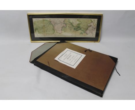
A COLLECTION OF GEORGE PHILIP & SON LINEN BACKED WALL MAPS OF EUROPE to include Philips' Comparative Wall Atlas of Europe, The London Geographical Institute, 2. Political x 2, 3. Climate - Summer Conditions, 4. Climate - Winter Conditions, 5. Temperature, 6. Natural Vegetation, 7. Economic, 8. Density of Population together with Philips' Contour War Map of Europe and W. & A.K. Johnston's 'Effective' Class-Room atlas of Great Britain & Ireland Relief and Communications map and Rainfall & Temperature (11)

Lot 159

A COLLECTION OF GEORGE PHILIP & SON LINEN BACKED WALL MAPS OF THE BRITISH ISLES, to include Philips' Comparative Wall Atlas of the British Isles 1. Relief of Land & Communications, 2. Political & Communications, 3. Temperature, 4. Annual Rainfall, Isobars & Winds, 5. Geological, 6. Agriculture & Fishing, 8. Density of Population, together with two contour charts by G. Bell & Sons and W. & A.K. Johnston's 'Effective' Class-Room atlas of Great Britain & Ireland Relief and Communications map (10)

Lot 164

EMANUEL BOWEN MAP OF STAFFORDSHIRE, c.1760, from 'The Large English Atlas', frame size 74 x 57 cm together with William Kip map of Staffordshire c.1637, frame size 53 x 63 cm, both handcoloured¦Condition Report:Both very brown all over¦

Lot 165

JOHN SPEED MAP OF STAFFORDSHIRE, c.1627, later hand colour, double glazed, frame size 54 x 66 cm¦Condition Report:Visible creases, damage and repairs¦

Lot 166

JOHN SPEED MAP OF SHROPSHIRE, c.1676, hand coloured, double glazed, frame size 51 x 65 cm¦Condition Report:Has creases but in generally good condition¦

Lot 168

A FRAMED AND GLAZED MAP OF SPAIN AND PORTUGAL TITLED 'HISPANIAE ET PORTVGALLIAE, Tabula generalis ad statum hodiernum in suas Provincias divisa per D.T. Lopez in nonnullis emendavit F.L.Gussefeld. Edentibus Homannianis Haeredibus'. Published 1782, hand coloured 51 cm x 61 cm

Lot 169

A THOMAS SURPLICE MAP OF THE RAILWAYS IN ENGLAND & WALES, 1842, A/F, framed and glazed 107 x 96 cm inc. frame¦Condition Report:Loss to base of map and extensive repairs¦

Lot 219

A ROYAL BLUE EXPRESS COACH SERVICES ENAMEL SINGLE-SIDED WALL SIGN, 20" x 36", map to top half; text to bottom half

Lot 230

A FOLIO FOLDER CONTAINING A COLLECTION OF LITHOGRAPH DRAWINGS OF THE LONDON AND BIRMINGHAM RAILWAY BY JOHN C. BOURNE, and descriptive text by John Britton 183, together with a framed and glazed related map.

Lot 480

2 FRAMED & GLAZED VINTAGE UK MAPS + EMBROIDERED MAP OF HAMPSHIRE

Lot 594

FRAMED FABRIC MAP, INDONESIA

Lot 8

A large framed and glazed early map of Nottinghamshire and an unframed ditto

Lot 1396

WORLD CUP 66 Silk head scarf for the World Cup 66 showing flags of the competing nations, in colour , the corners show World Cup Willie x 2, a map of England showing the venues and the official 1966 World Cup flag. Some folds. Generally good

Lot 1397

WORLD CUP 66 Two scarce booklets covering the 1966 World Cup, a 1966 Hungarian guide with World Cup Willie on the front in colour, titled Labdarugo VB 1966 by Borbely Pal plus a 36 page magazine VB 1966 showing World Cup Willie on the front and a map of England on the back showing the venues for the World Cup . the inside pages detail qualifying plus other previous World Cups and details/pictures of the teams that qualified plus Hungary content. Both are seldom seen in this country. Good

Lot 56

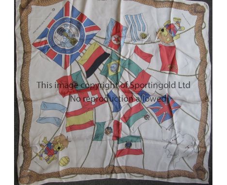
World War II Japanese Surrender - A Nippon Times 'Unconditional Surrender by Japs Completed at 20 minute Ceremony, The End of the Long Road Back' artificial silk scarf, September 1945 printed with a map of Japan with Allied Flags; and a Japanese Rising Sun cloth of naval ensign type, 42 x 45cm and 76 x 40cm approx (2)
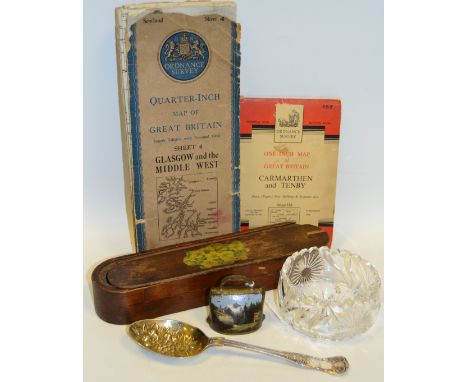
Lot 15

A large estate map, in the area of Masham and Kirkby Malzeard, linen backed

Lot 412

Two mantel clocks, a desk stand, the inkwells with mounts in the form of cat heads, two tea caddies, other boxes, and a pictorial map of England and Wales (9)

Lot 50

A Map of Briddy Farm in the parish of Burton Bradstock, County of Dorset, the property of W M Hussey Esq, in two parts, slight staining, some tears/minor loss, unframed (2)

Lot 318

Richard Bloome - 'A Map of The County of Somerset', 10" x 13"; together with a further later reproduction map of Canada, 16" x 21" (2)

Lot 105

19th Century engraved map - Chili and the United Provinces Of South America, published by Lizars of Edinburgh, 52.5cm x 33.5cm Condition:

Lot 106

Antique Blaeu hand coloured engraved map - Somerset, 42cm x 54cm, framed and glazed Condition:

Lot 107

Mid 20th Century relief wall map - Iceland, 50cm x 68cm, framed and glazed Condition:

Lot 51

Modern wall map - Bristol Channel, 71cm x 106cm, framed and glazed Condition:

Lot 1341

A REGENCY OVAL LINEN MAP SAMPLER, MARY DEAN 1817, framed and glazed. Sampler 17ins x 15.5ins.

Lot 4067

'Gilbert's New Map of Europe', London: January 10th 1839. 19th-century hand-coloured engraving, dissected and laid on linen, complete with slipcase. 127cm x 130cm (unfolded).

Lot 4326

A large vintage style map of Central London, 225cm wide, 155cm high

Lot 766A

'The Path Finder' a chrome plated compass and map reader, combined in pendant form, leather cased, 1930/40

Lot 3059

A Robert Mordon map of Derby, a bookplate map of Derby and an 1817 Pilgrimage to Canterbury, framed (3)

Lot 3091

A 18th century map of 'Derbyshire' by Robert Morden, together with a later Morden map of Oxfordshire, and another 18th century map of Derbyshire, a map of Nottinghamshire and a map of a Suffolk (5)

Lot 3187

18th Century Bowen map of Worcestershire and Herefordshire, unframed (2)

Lot 3201

An oval famed oil painting; together with a map of Derbyshire, a landscape print and an unframed oil on canvas (af) (4)

Lot 745

KNYFF & KIP Britannia Illustrata facs. ed. 1984, Bungay, 4to orig. cl. d/w plus BERESINGER, Y. British County Maps 1st.ed. 1983, Woodbridge, 4 to orig. cl. d/w, plus RAVENHILL, M.R. Devon Maps and Map-Makers 2 vols. 1st.ed. 2002, Exeter, 8vo in s/case, plus 1 other (5)

Lot 417

Mid 17th century Bleau map of the the County of Lancashire in Hogarth frame

Lot 430

Framed coloured Map of Lincolnshire in hogarth frame

Lot 432

John Speed coloured framed map of the County of Bedfordshire first edition 1615

Lot 33

Boxes and Objects - an Edwardian mahogany mantel clock, barber pole stringing throughout; three Beswick Hounds; a pair of resin Kingfisher models; flat iron; a framed map of Derbyshire; pound notes; etc qty

Lot 47A

Ordnance Survey - Quarter Inch Map of Great Britain, Sheet 4 Glasgow and the Middle West, first published 1946; another, One Inch, Carmarthen and Tenby 152; An E.P.N.S. Kings pattern table spoon, the gilt bowl embossed with flowers and grapes; a Swiss type goat bell, painted with Alpine scene, 6.5cm high; a mid 20th century treen rounded rectangular two section pencil case, the sliding cover with primrose transfer, 27cm long; a heavy clear glass bowl, engraved with flowerheads and foliage, star cut base, undulating rim, 10cm diam

Lot 84

Pieter van den Keere, a coloured map, Sussex, 18th century

Lot 457

A antique hand-coloured printed map of Europe entitled 'Imperium Carlimagni,' 40x55cm, together with another entitled 'Matricule de l'empire repartition etats des villes selon les constitution de charlequint,' 47x63cm and a hand-coloured printed view of Portsmouth harbour entitled 'Le Port De Portsmouth,' 19x23cm (3)

Lot 192

MIXED LOT OF PENCIL SIGNED AND OTHER BLUE AND WHITE PRINTS PLUS MAP OF LIVERPOOL, ETC.

Lot 294

FRAMED MAP OF THE WEST INDIES, MILITARY PHOTOGRAPH AND TWO PRINTS

Lot 676

After J Blaeu, Bedfordiensis, a coloured map of Bedfordshire, text verso, in double sided glazed frame, 43cm by 25.5cm

Lot 688

A 17th century John Speed map of the Isle of Wight, coloured engraving, paper labels verso, 54.5cm by 36.5cm

Lot 370

John Speede, original sparsely coloured map of 'Breknoke' (Brecon). Sudbury & Humble edition with English text verso. Hogarth frame. 38.5 x 52cm approx. (B.P. 24% incl. VAT) CONDITION REPORT: A little discoloured in places, with noticeable creasing down centre spine.

Lot 372

John Speede, an original sparsely coloured map of 'Caermarden' (Carmarthen), Sudbury & Humble edition with English text verso. 39 x 55.5cm approx, hogarth frame. (B.P. 24% incl. VAT) CONDITION REPORT: Appearing in good original condition overall, slightly discoloured. Glass is broken, no obvious damage.

Lot 384

John Speede, and original, sparsely coloured map of Flintshire, 'Sudbury and Humble' edition with English text verso. Hogarth frame. 40 x 51.5cm approx. (B.P. 24% incl. VAT)

Lot 422

Welsh map illustrated with symbols, figures and texts, illustrating the history of Wales, 'In Honour of Wales', limited edition of only 569. 60 x 45cm. Oak framed and glazed.(B.P. 24% incl. VAT)

Lot 48

An Early Coloured Map of Warwickshire by Robert Morden, 37 x 42 cms , together with another similar early coloured map of the County of Monmouth by Robert Morden, 37 x 42 cms

Lot 137

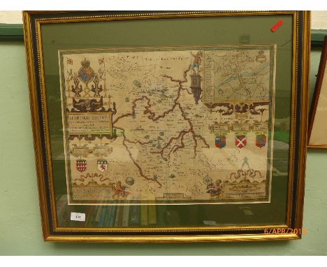
A 'map of the county of Middlesex from an actual survey made in the years 1819 and 1820 by C & I Greenwood, published by the proprietor C Greenwood & Co., 13 Regent Street, Pall Mall, London','corrected and published July 4th 1829', with hand-coloured highlights and detail,image 52.5 x 64cm, framed

Lot 193

A framed ordnance survey map, 'City of Sunderland and Surrounding Area', a framed map of Newcastle and three other framed pictures

Lot 43

Ten assorted frame pictures including Newcastle Empire Advertisements, map of Gateshead in the 1870's, black and white engravings etc

Lot 316

Edwardian London Electric Railways Pocket Map and Others, printed on paper, a folding pocket example, depicting a map of London Electric Railways, printed by Johnson, Riddle & Co Ltd, together with two 1928 paper folding pocket maps ' Summer 1928 Underground Map of the Electric Railways of London' and No 2 'Map of the London General Bus Routes' both printed by Waterlow & Sons, and a 1914 paper flyer Great Western Railways 'Excursions to London from Swindon' printed by J.W. Arrowsmith Ltd Bristol (folded) F-G (4)

Lot 197

A Framed Embroidery Depicting Map of Great Britain

Lot 76

A Set of Three Graduated Modern Leather Mounted Cases, Decorated with World Map, Largest 45cm Long

Lot 328

TIN OF MAGNIFIER GLASSES, MAP MEASURE ETC

Lot 283

15 vintage maps including Bartholomew's 16 Grampians, AA throughway map of London, military editions, AA touring wallet, Harding guide map to Horncastle and Woodhall Spa etc.,

Lot 268

A mixed lot consisting of military map case, copy case, military shovel and pair of stirrups.

Loading...Loading...
  • 109182 item(s)
    /page

Recently Viewed Lots