We found 109182 price guide item(s) matching your search
There are 109182 lots that match your search criteria. Subscribe now to get instant access to the full price guide service.
Click here to subscribe- List
- Grid
-
109182 item(s)/page


Lot 493
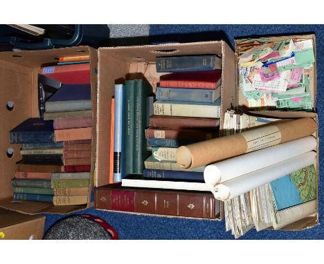
TWO BOXES OF BOOKS, together with two boxes of Railway ticket stubbs and maps, to include Plot, Robert 'The Natural History of Staffordshire', 'A Box of Studies in Plant form with some suggestions for their application to Design' by A.E.V. Lilley and W Midgley Blunt, Wilfrid 'The Art of Botanical Illustration' etc Condition Report Due to the low estimate of this lot and the quantity of tickets, it is not cost effective to photograph all the tickets(Condition: Republished 1973 9SBN - 0901598658, plates and folding map are present, binding is in good order with only light scuffing to the corners)

Lot 382
A collection of 18th century bindings, including Homer's Iliad, translated by Pope, printed by Bowyer for Lintott, London 1720 (5 vols), Breviarum Lemovicense, 1736, Poems of Horace, London, Typis H Parker, 1726, Poems by William Cowper, London 1787, Mounteney's Demosthenes, London, F & C Rivington et al, 1799, with folding map, Histoire Romaine, Paris, Chez la Veuve Estienne, various dates, 9 vols, 8 with Charles Smith bookplate (Tome Premier dated 1738, two folding maps, front board missing) and Theatre de Voltaire, 5 vols, G Le Roy, Caen, 1788, together with a pocket Odyssey of Homer, London 1805 (Q)


Lot 32b
This is an attractive map of the voyage of Captain Cook in the Pacific Ocean near the islands of New Caledonia and Vanuatu. Captain Cook discovered the islands on his second voyage, and they included New Caledonia and several islands in the Vanuatu archipelago. Cook called Vanuatu the New Hebrides, the name that was used for the islands until the Republic of Vanuatu was established in 1980. Cook’s route through Vanuatu and around New Caledonia is traced here and there are even references to specific dates where he and his crew landed. Both island groups had been completely unknown to Europeans before Cook’s arrival in 1774. The map was created by James Cook and engraved by Robert Menard for the French edition of Cook’s voyages and published in 1778. The Library of Congress only has five records of the map in collections around the world. 19 1/2 x 15 1/2 in.

Lot 32d
1600’s Map of Dutch Fleet Invading England at Medway. This map features the Dutch fleet preparing to invade England during the Second Anglo-Dutch War. Called the Raid on the Medway, the attack was launched in 1667, and the successful attack by the Dutch was one of the worst defeats in British naval history; it ended in a favorable peace for the Dutch. You can see England and English towns named at the top of the map, and the large Dutch fleet seems to be like an armada ready to strike. The Raid on the Medway was a serious blow to the reputation of the English crown. King Charles felt personally offended by the fact the Dutch had attacked while he laid up his fleet and peace negotiations were in progress, but history says he conveniently forgot he didn’t negotiate in good faith. 15 x 19 in.

Lot 32e
This early map of the British Isles was probably engraved in the mid 1500’s. It is a black and white engraving that features Scotland, England, and Ireland, and all the place names on the map are in Latin (Scotia for Scotland, Anglia for England, and Hibernia for Ireland). We believe it predates Mercator maps and Hondius maps. Mercator (1512 - 1594) was a leading cartographer from the Netherlands, and Hondius, also known by his Dutch name Joost de Hondt (1563 - 1612) was also a leading cartographer from the Netherlands. The size is 10 1/2 x 7 in. Please note that all sales are final. No refunds will be given under any circumstances.


Lot 1013
WHITE, WIlliam. History, Gazetteer and Directory of Suffolk. William White, Sheffield, 1885 4th edition. In original publisher’s cloth, with blind stamped borders. Gilt motif to front board and gilt title to spine. With original folding map. [1]Condition report: Some fraying to cloth, head & tail of spine.Small splits in cloth at front hinge.Map torn on one of the folds.Lacking front free endpaper.


Lot 16
JOHN SPEED coloured antiquarian map - 'Montgomeryshire, Described by Christopher Saxton, Augmented and Published by John Speed and are to be solde in Popes head alley against the Exchange of London, by John Sudbury and George Humbell, Cum Privilegio 1610', includes Montgomery town plan, verso Alphabetical Table of All Townes', framed and glazed to verso, 38 x 51cms

Lot 17
JOHN SPEED coloured antiquarian map - 'Penbrokeshyre' (Pembrokeshire) with inset plan of St David's, John Sudbury and George Humbell, edition 1610, 39 x 52cmsThere are two small areas where paper is starting to crack, there is also some rippling under the mount in a few places.Colours look good, nice and bright. Nothing on reverse.

Lot 19
JOHN SPEED double engraving map of 'Glamorganshyre', with plans of 'Cardyfe' and 'Landaffe', hand-coloured, Sudbury & Humble edition, 1610, 38 x 51cm (framed, enclosed back)Heavy creasing in places otherwise all good, no damage.Good colours.On the reverse there are photocopies of what I can only assume as the back of the map and they just have not double-glazed it.


Lot 550
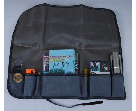
U2, Achtung Baby "Users Kit", an Island Records 1991 promotional tool kit to include Berlin/Trabant poster map, screwdriver, spanner, torch, keyring, CD and cassette, housed in a green nylon folding wallet printed with the band name and album title, limited to an edition of 200.Condition report: Lots 501 - 591 are from the collection of Jonathan Ruffle, a British writer, director and producer, who has made TV and radio programmes for the BBC, ITV, and Channel 4. During his time as a producer of the Radio 1 show from the mid-1980s-90s he collected the majority of the lots on offer here. These include rare vinyl, acetates, and Factory Records promotional items. The majority of the vinyl lots being offered for sale are in Mint or Near-Mint condition – with some having never been played.

![[HISTORY] Fuller, Thomas. The Historie of the Holy Warre, fourth edition, by Buck, London, 1651, full leather (upper board d](https://cdn.globalauctionplatform.com/9b5dcbce-8270-4f12-8792-abb400a86b7f/7773dcbd-1e4a-43e0-a866-ac2c00f4cc8b/468x382.jpg)
![[HISTORY]. INDIA The King Emperor and His Dominions. Souvenir of the Coronation Durbar of H.I.M. George V, Delhi, December,](https://cdn.globalauctionplatform.com/9b5dcbce-8270-4f12-8792-abb400a86b7f/1369f187-c1df-43fd-b0ef-ac2c00f4d9aa/468x382.jpg)
Lot 646
[HISTORY]. INDIA The King Emperor and His Dominions. Souvenir of the Coronation Durbar of H.I.M. George V, Delhi, December, 1911, with the compliments of Burroughs Wellcome & Co., London, no date [1911], full crimson leather (rubbed), all edges gilt, illustrations, octavo; Coronation Durbar, 1911, being a reprint of articles and telegrams previously published in the Pioneer, second edition, Pioneer Press, Allahabad, 1912, dark green cloth gilt, frontispiece and a further twenty-four plate illustrations (as called for), folding map at end, quarto; Fortescue, John. Narrative of the Visit to India of their Majesties King George V and Queen Mary and of the Coronation Durbar Held at Delhi 12th December 1911, first edition, Macmillan, London, 1912, blue cloth gilt, top edges gilt, tissue-guarded frontispiece and a further thirty plate illustrations (as called for), folding plan at end, octavo; and two other works, (5).
![[MODERN FIRST EDITIONS] Waugh, Evelyn. Scoop, first edition, Chapman & Hall, London, 1933, decorative cloth, octavo; and](https://cdn.globalauctionplatform.com/9b5dcbce-8270-4f12-8792-abb400a86b7f/01cfdf65-7462-4448-abcc-ac2c00f4f008/468x382.jpg)
![[TOPOGRAPHY]. EXETER, DEVON Izacke, Richard & Samuel. Remarkable Antiquities of the City of Exeter: giving an Account of](https://cdn.globalauctionplatform.com/9b5dcbce-8270-4f12-8792-abb400a86b7f/d85d8bc2-43ba-436c-aaba-ac2c00f4fc94/468x382.jpg)
Lot 685
[TOPOGRAPHY]. EXETER, DEVON Izacke, Richard & Samuel. Remarkable Antiquities of the City of Exeter: giving an Account of the Laws and Customs of the Place; the Offices, Court of Judicature, Gates, Walls, Rivers, Churches, and Immunities; the Titles and Privileges of the several Corporations, and their distinct Coats of Arms... : with a Catalogue of all the Bishops, Mayors, and Sheriffs, from the Year 1049, to 1677, third edition, for the author, London, 1734, full leather (joints cracked; lacking spine label), engraved armorial frontispiece, engraved folding plate of the Cathedral Church, further armorials within the text, octavo (lacking folding map; title page trimmed and re-laid to support sheet).
![[TOPOGRAPHY]. EXETER, DEVON Jenkins, Alexander. The History and Description of the City of Exeter, and its Environs, Ancient](https://cdn.globalauctionplatform.com/9b5dcbce-8270-4f12-8792-abb400a86b7f/2a312e54-ef1d-4c6d-8a4f-ac2c00f4fd8d/468x382.jpg)
Lot 686
[TOPOGRAPHY]. EXETER, DEVON Jenkins, Alexander. The History and Description of the City of Exeter, and its Environs, Ancient and Modern, Civil and Ecclesiastical... Also a General and Parochial Survey and Description..., Hedgeland, Exeter, 1806, full leather (re-backed; scuffed), engraved frontispiece, engraved folding map of the City, two further maps ('Danmonia Romana' and 'Saxon Danmonia'), two plans and five further plate illustrations, octavo (lacking one plate; ex library).
![[TOPOGRAPHY]. SOMERSET Collinson, Rev. John. The History and Antiquities of the County of Somerset, three volumes, by Cruttw](https://cdn.globalauctionplatform.com/9b5dcbce-8270-4f12-8792-abb400a86b7f/8b51fa4b-ef6f-42d9-ae2c-ac2c00f50075/468x382.jpg)
Lot 689
[TOPOGRAPHY]. SOMERSET Collinson, Rev. John. The History and Antiquities of the County of Somerset, three volumes, by Cruttwell, Bath, 1791, full leather (re-backed, with incomplete spine labels), folding map frontispiece, a further thirty-nine engraved plate illustrations, subscribers list, quarto; together with Weaver, Rev. F.W., & Bates, Rev. E.H., editors. Index to Collinson's History of Somerset, Barnicott & Pearce, Taunton, 1898, brown cloth, quarto (latter ex library), (4).
![[TOPOGRAPHY]. SOMERSET Phelps, Rev. W. The History and Antiquities of Somersetshire, Vol. I, Parts I & II, Nichols, Lond](https://cdn.globalauctionplatform.com/9b5dcbce-8270-4f12-8792-abb400a86b7f/add29317-2ddb-4ec7-9bdd-ac2c00f50217/468x382.jpg)
Lot 691
[TOPOGRAPHY]. SOMERSET Phelps, Rev. W. The History and Antiquities of Somersetshire, Vol. I, Parts I & II, Nichols, London, 1836, & Vol. I, Parts III & IV, Nichols, London, 1836, bound as one, modern half leather retaining original stiff paper covers, twenty-nine plate illustrations (only), including maps, further text illustrations, large quarto; together with Phelps, Rev. W. The History and Antiquities of Somersetshire, Vol. II, by Nichols for the author, London, 1839, black half leather, the spine in compartments gilt, top edges gilt, frontispiece, map, seven plate illustrations, further text illustrations, large quarto, (2).
![[TRAVEL] Bosman, William. A New and Accurate Description of the Coast of Guinea, Divided into Gold, the Slave, and the Ivory](https://cdn.globalauctionplatform.com/9b5dcbce-8270-4f12-8792-abb400a86b7f/91a5268e-221c-4e74-981f-ac2c00f506de/468x382.jpg)
Lot 695
[TRAVEL] Bosman, William. A New and Accurate Description of the Coast of Guinea, Divided into Gold, the Slave, and the Ivory Coasts, containing a Geographical, Political, and Natural History of the Kingdoms and Countries: with a Particular Account of the Rise, Progress, and Present Condition of all the European Settlements upon that Coast; and the Just Measures for Improving the several Branches of the Guinea Trade, written originally in Dutch... And now faithfully done into English, second edition, for Knapton, Midwinter, Lintot, Strahan, Round & Bell, London, 1721, full leather, remains of engraved folding map frontispiece by Moll, seven further engraved plate illustrations (only; one torn, with 30% loss), octavo.
![[TRAVEL] Barrow, John. A Collection of Authentic, Useful, and Entertaining Voyages and Discoveries, Digested in a Chronologi](https://cdn.globalauctionplatform.com/9b5dcbce-8270-4f12-8792-abb400a86b7f/fca02fee-f657-4a12-a789-ac2c00f7bbaf/468x382.jpg)
Lot 704
[TRAVEL] Barrow, John. A Collection of Authentic, Useful, and Entertaining Voyages and Discoveries, Digested in a Chronological Series, three volumes, for Knox, London, 1765, full speckled calf (re-backed), two folding map frontispieces, one further folding map, one folding chart and five further plate illustrations (one folding), small octavo.
![[TRAVEL]. CENTRAL AMERICA Stephens, John L. Incidents of Travel in Central America, Chiapas, and Yucatan, first British edit](https://cdn.globalauctionplatform.com/9b5dcbce-8270-4f12-8792-abb400a86b7f/6b3eeacd-2562-42b1-aaa0-ac2c00f7bd29/468x382.jpg)
Lot 706
[TRAVEL]. CENTRAL AMERICA Stephens, John L. Incidents of Travel in Central America, Chiapas, and Yucatan, first British edition, two volumes, Murray, London, 1841, modern quarter leather with marbled boards, folding map, seventy-eight plate and text illustrations, including frontispieces (32 + 46; one more than called for), octavo (foxed).
![[TRAVEL]. CHILE Molina, Abbe Don J. Ignatius. The Geographical, Natural, and Civil History of Chili, translated [into Englis](https://cdn.globalauctionplatform.com/9b5dcbce-8270-4f12-8792-abb400a86b7f/5e4b5095-35fc-4fd4-a1bf-ac2c00f7be03/468x382.jpg)
![[TRAVEL]. ASIA Murray, Hugh. Historical Account of Discoveries and Travels in Asia, three volumes, for Constable et al., Edin](https://cdn.globalauctionplatform.com/9b5dcbce-8270-4f12-8792-abb400a86b7f/f25cee4c-5fe8-4ee4-b276-ac2c00f756ab/468x382.jpg)
Lot 708
[TRAVEL]. ASIA Murray, Hugh. Historical Account of Discoveries and Travels in Asia, three volumes, for Constable et al., Edinburgh / London, 1820, modern tan buckram with brown leather title labels to spine, folding map frontispiece, three further folding maps, octavo (ex Foreign Office library).
![[TRAVEL]. INDIA Penny, F.E. Southern India, first edition, Black, London, 1914 (20s. Series), decorative orange cloth (sligh](https://cdn.globalauctionplatform.com/9b5dcbce-8270-4f12-8792-abb400a86b7f/034bf6a9-cd2a-4b95-a389-ac2c00f75b9c/468x382.jpg)
Lot 709
[TRAVEL]. INDIA Penny, F.E. Southern India, first edition, Black, London, 1914 (20s. Series), decorative orange cloth (slightly stained patch to spine), fifty paper-protected colour plate illustrations by Lady Lawley (including frontispiece, as called for), folding sketch map (at end), two pages of publisher's advertisements, two-page publisher's list, quarto (lower hinge weak).
![[TRAVEL]. Fox, Frank. Australia, first edition, Black, London, 1910, decorative blue cloth gilt, top edges gilt, seventy-fiv](https://cdn.globalauctionplatform.com/9b5dcbce-8270-4f12-8792-abb400a86b7f/32e21a3e-cc3d-424b-bb49-ac2c00f75c9f/468x382.jpg)
Lot 710
[TRAVEL]. Fox, Frank. Australia, first edition, Black, London, 1910, decorative blue cloth gilt, top edges gilt, seventy-five paper-protected colour plate illustrations by Percy Spence (including frontispiece, as called for), folding sketch map (at end), four-page publisher's list, quarto; together with Koebel, W.H. South America, first edition, Black, London, no date [1912], decorative green-grey cloth, top edges gilt, seventy-five paper-protected colour plate illustrations by A.S. Forrest (including frontispiece, as called for), folding sketch map (at end), two pages of publisher's advertisements, quarto; and three other works from Black's 20s. series, (5).
![[MISCELLANEOUS] Wigram, Edgar. Northern Spain, first edition, Black, London, 1906, decorative dark orange cloth, top edges gi](https://cdn.globalauctionplatform.com/9b5dcbce-8270-4f12-8792-abb400a86b7f/a4b1cd2b-45ed-47f6-9e30-ac2d011ac3ac/468x382.jpg)
Lot 736
[MISCELLANEOUS] Wigram, Edgar. Northern Spain, first edition, Black, London, 1906, decorative dark orange cloth, top edges gilt, seventy-five paper-protected colour plate illustrations by the author, folding sketch map (at end), four-page publisher's list, quarto (hinges weak; one plate detached); Holland, Clive. Wessex, first edition, Black, London, 1906, decorative dark green cloth gilt, top edges gilt, seventy-five paper-protected colour plate illustrations by Walter Tyndale, folding sketch map (at end), quarto (spine with damp stain towards head); and three other titles from Black's 20s series, (5).
![[MISCELLANEOUS] Henderson, John. The West Indies, first edition, Black, London, 1905, decorative pale blue cloth (spine even](https://cdn.globalauctionplatform.com/9b5dcbce-8270-4f12-8792-abb400a86b7f/633a7c76-fc70-4f36-b96e-ac2c00f52fe0/468x382.jpg)
Lot 737
[MISCELLANEOUS] Henderson, John. The West Indies, first edition, Black, London, 1905, decorative pale blue cloth (spine evenly browned), top edges gilt, seventy-four paper-protected colour plate illustrations by A.S. Forrest, four-page publisher's list, quarto (upper hinge repaired); Holland, Clive. Warwickshire, first edition, Black, London, 1906, decorative blue cloth, top edges gilt, seventy-five paper-protected colour plate illustrations by Frederick Whitehead, folding sketch map (at end), eight-page publisher's list, quarto; and six other Black titles, (8).
![[MAP]. INDIA Thacker's Reduced Survey [folding] Map of India, by J.G. Bartholomew, fifth edition, Thacker, Calcutta & Lon](https://cdn.globalauctionplatform.com/9b5dcbce-8270-4f12-8792-abb400a86b7f/324df604-a7c4-440e-80bc-ac2c00f530e9/468x382.jpg)
Lot 738
[MAP]. INDIA Thacker's Reduced Survey [folding] Map of India, by J.G. Bartholomew, fifth edition, Thacker, Calcutta & London, 1914, one inch to seventy English miles, colour printed, with plans of Bombay, Calcutta and Madras, approximately 101cm x 92cm, blue cloth covers (index detached; some place-names underlined).
![[MAP]. YORKSHIRE Speed, John (1552-1629), 'The West Ridinge of Yorkeshyre', engraved map, sold by Thomas Bassett and Richard](https://cdn.globalauctionplatform.com/9b5dcbce-8270-4f12-8792-abb400a86b7f/21e54785-c59d-47a5-a15b-ac2c00f53538/468x382.jpg)
![[MAP]. SUFFOLK Speed, John (1552-1629), 'Suffolke', engraved map, sold by George Hu[m]ble, hand-coloured, English text verso](https://cdn.globalauctionplatform.com/9b5dcbce-8270-4f12-8792-abb400a86b7f/6a45a15f-98c9-4c77-8173-ac2c00f53667/468x382.jpg)
![[MAP]. MEXICO Sanson, Nicolas (1600-1667), 'Audience de Mexico', engraved map, hand-coloured (colouring now faded), 17.25cm](https://cdn.globalauctionplatform.com/9b5dcbce-8270-4f12-8792-abb400a86b7f/f3023db4-6554-4ec3-a060-ac2c00f5377d/468x382.jpg)
![[MAP]. VENEZUELA Blaeu, Willem Janszoon (1571-1667), 'Venezuela cum parte Australi Novae Andalusiae', engraved map, hand-co](https://cdn.globalauctionplatform.com/9b5dcbce-8270-4f12-8792-abb400a86b7f/7ef9b199-12d7-47f9-b569-ac2c00f5388c/468x382.jpg)
-
109182 item(s)/page