We found 109182 price guide item(s) matching your search

Refine your search

Year

Filter by Price Range
  • List
  • Grid
  • 109182 item(s)
    /page

Lot 687

A Champion spark plugs tin advertising map sign, dated December 1973, 18 x 30".

Lot 700p

A Hercules cycles pictorial showcard, an ROP map and a Michelin tyre lever.

Lot 443

A MAP OF GREAT BRITAIN AND IRELAND, TOGETHER WITH A BOAT HULL DISPLAY SHELF.

Lot 317

Box of Mixed Collectables including White Metal Horse, Vintage Map Measure, Stamps, Miniature Clock, etc

Lot 654

Antique Map Engraving of Hampshire ( Hantshire ), colour hand tinted, 40cms x 53cms, framed and glazed

Lot 669

Two Antique Hand Coloured Map Engravings - Cornwall, 30cms x 40cms, framed and glazed plus Gloucestershire ( Glocestrie ), 28cms x 31cms, framed

Lot 673

After Degas, Pastel of the Seated Nude Female, 27cms x 40cms, framed and glazed together with Reproduction Map of France and Two Reproduction Prints of Versailles

Lot 703

Reproduction Saxton's Map of Cornwall 1596, 36cms x 49cms, framed and glazed

Lot 89

1920's Leather Cased Set of Bartholomew's Maps of England and Wales, no's 1 to 37, together with map measure and key, 38cms wide

Lot 122

A late 19th century map of Edinburgh by John Bartholomew and Co, Edinburgh. 95cm in width by 70cm in height

Lot 124

Map of Scotland [ORTELIUS(ABRAHAM)] Scotia Tabula, a framed double-page hand coloured engraved map, of Scotland c1600 Oriented to the west. 48cm in width by 37cm in height¦

Lot 9

A Czechoslovakian aviation tour award, 1938,a chrome plated map of the country with coloured glass inserts to indicate locations of the nine airbases/airports visited, surmounted by a Czechoslovakia Pilot's badge, 15cm wide, on metal plaque stamped 1918-1938, on marble base. For further information on this lot please visit Bonhams.com

Lot 125

Cary's New and Correct English Atlas with forty six engraved county maps with hand coloured outline and general map 'South Britain' published 1793 morocco over marbled boards - Condition Report

Lot 126

Cary's New Map of England and Wales with part of Scotland, engraved maps with hand coloured outline published 1794 with morocco and marbled boards, rebound - Condition Report

Lot 128

Cary's New Itinerary published 1817 in tree calf, Letts's folding cycling map of England and Wales, Harmsworth Atlas folding Motor Map of the British Isles, XXth Century Citizen's Atlas and Harmsworth Universal Atlas (5) - Condition Report

Lot 129

John Ogilby (1600-1676) - The Extended Road from Oakham to Richmond Yorkshire and the Continuation of the Extended Road from Oakeham to Richmond hand coloured strip road maps, Plate Nos. 48 and 49, 36cm x 46cm and Thomas Bowen hand coloured map of England 32cm x 22cm - Condition Report

Lot 223

Christopher Saxton hand coloured map, Derbyshire, from Saxton's Britannica, 28cm x 32cm - Condition Report

Lot 369

After Estra Clark (British 1904-1993): 'Historic York', colour map pub. Ben Johnson & Co, York 1947, - Condition Report

Lot 136

A SLIP CASE CONTAINING FOUR COLOUR FOLD-OUT LINEN BACKED MAPS OF THE HIMALAYAS, North West, North East, South East and South West, by Edward Stanford LTD. Cartographers to His Majesty, each map 73cm x 54cm, the green slip case gilt stamped, 'Himalaya s' to the spine, 19cm x 13cm

Lot 228

A C.1607 LATER HAND COLOURED COPPER PLATE ENGRAVED MAP OF 'PENBROK' after the original by Christopher Saxton, this copper plate produced by Owen and Kip, 28cm x 33.5cm, decoratively double mounted in slender gilt frame

Lot 235

FOUR VARIOUS COLOURED LOCAL MAPS to include; counties, and a road map depicting the route, from Chipping Campden through Evesham to Worcester, 18cm x 12cm

Lot 1

ÆŸ "Descriptio Imperii Turcici", a map of the Middle East including Anatolia, Egypt, the Arabian Gulf and Persia, printed on paper [Probably Amsterdam, c. 1606] single leaf, page "758" only from a larger body of work, some early hand-colouring in yellow now faded, edges a little browned, reverse with text for the "Descriptio Insularum Japan", 105 by 185 mm.; tipped onto card mount, framed and glazed This leaf is likely from the Tabularum Geographicarum Contractarum of Pierre Bertius (1565-1629) printed by Cornelium Nicolai in Amsterdam in 1606.  

Lot 3

ÆŸ Brion. "Perse, Turquie Asiatique et Arabie", engraved map on paper [Paris, 1786] single leaf, engraved map of Persia, Asiatic Turkey and Arabia with surrounding oceans and seas including the Black Sea, Mediterranean Sea and Indian Ocean, additional highlights in colour added by hand, focusing particularly on the Arabian peninsula, a few small spots and some light browning, overall bright and attractive condition, c. 230 by 265 mm.; framed and glazed, "Sebastian D'Orssai Ltd" label to the reverse of the frame 

Lot 6

ÆŸ Jean Chardin, Voyages du Chevalier Chardin en Persen et autres lieux de l'Orient, printed in French, edition nouvelle by Le Normant [Paris, 1811]  11 volumes, including the Atlas volume, complete, comprising 10 volumes (in 8vo), with half-titles, bound in contemporary morocco-backed boards, excellent condition, and the Atlas volume (folio) with half-title, engraved portrait, large folding engraved map, 10 folding engraved plans and 71 engraved plates (on 63 sheets), final two plates a little darkened, else very clean and crisp condition, marbled paper doublures, later morocco-backed boards, good condition A fine and beautifully illustrated set of Chardin's travel and voyages through Persia and the Orient, including trips to Kashan, Isfahan and Qom.

Lot 73

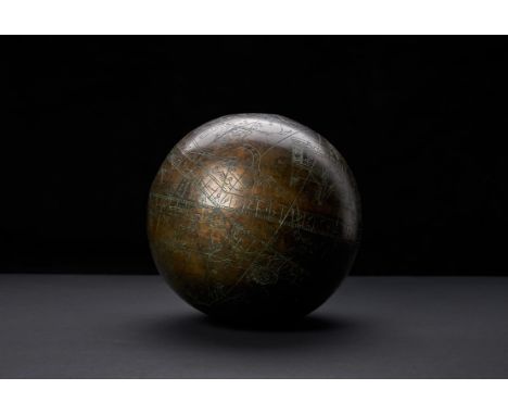
A Celestial Globe, engraved in brass by "Iskandrani", depicting zodiac signs and stellar constellations [probably Safavid Persia, dated 1128 AH (1716 AD)] single brass sphere, engraved with signs of the zodiac, individual stars and stellar constellations, inscribed throughout with jagged inscriptions carved into the brass by hand, latitudinal and longitudinal lines present, brass a little darkened, some oxidisation to sections of engravings, a few small areas of rubbing and light surface scratches, c. 200 mm. in diameter Celestial globes of this nature were used by astrologers, astronomers, Islamic scholars and scientists alike. They were popularised in the Timurid period by patrons who extended their support for the arts into the sciences as well, and fine examples of these scientific and astrological instruments including astrolabes and other astrological globes from this period are predominantly from the Eastern Ilkhanate regions of Samarkand and Herat. Celestial globes of this nature portray stars and constellations as if viewed from above, and were often used as astronomical instruments to guide the viewer and serve as a map of the heavens. The exact proportions and presence of lines also gave these objects a religious purpose as they could be used to tell prayer times and also establish the location of Mecca. A similar example, dated 1197 AH (1782-83 AD) was sold in Sotheby's, 25th April 2012, lot 584, realising £38,450.  

Lot 256

EDWARD J. CHERRY, YE ANCIENT HOUSE OF MOLL, CATHEDRAL CLOSE, etching, signed, 17cm x 10.5cm Mounted, framed and under glass, along with other etchings and prints including an etching by Wilfred Appleby, a print of Perspective View of the Royal Palace and Gardens at Hampton Court and a map of Kent, each framed and under glass (7)

Lot 47

MID-20TH CENTURY MAP BY GEORGE PHILIPS & SONS, illustrating the growth of Russia 1462-1939, 118cm x 83cm

Lot 65

GROUP OF THREE PICTURES, including a map by Johan Blaeu entitled Atlas Novus 1654, each framed

Lot 1282

Cunninghame [Graham R.B.]: The Dream of The Magi, Limited Edition of 280, ink signed by the author, Rodeo, Progress, His People, Notes on The District of Monteith for Tourists and Others, containing map and others, all by the author. (30)

Lot 297

In the Footsteps of Marco Polo hardback by Major Clarence Dalrymple Bruce, 1st Edition, 1907 (no map), signed and dedicated by the author to John Swire

Lot 130

Robert Morden (circa 1650-1703) map of Northamptonshire, framed and glazed, 37cm x 43cm

Lot 135

Robert Morden (circa 1650-1703) coloured map of Huntingtonshire, framed and glazed, 37cm x 43cm

Lot 246

Small collection of Norfolk interest books including wentworth Day, "The Rabbitskin Cap", "Norwich Cathedral", Ketton Cramer, "Faden's Map of Norfolk" published Larks Press etc

Lot 283

A framed and glazed map of 'Barkshire' by Robert Morden, 35.5cm x 42cm

Lot 322

Chart tube with military map of Swaffham and East Dereham. Geographical section, General Staff No.3907. Published at the War Office 1941

Lot 355

Original Hadrill and Horstmann Pluslite counterbalance map reading lamp - silver in colour

Lot 356

Original Hadrill and Horstman Pluslite counterbalanced map reading lamp - cream in colour

Lot 1183

A mixed lot of military uniform items including flying helmet, B.D. trousers and a leather map case

Lot 112

DUGDALE THOMAS.  Curiosities of Great Britain, England & Wales Delineated. 4 vols. Eng. frontis, titles & plates. Hand col. double page map. Half calf. N.d.

Lot 12

BULMER T. F.  History, Topography & Directory of East Cumberland. Fldg. map. Orig. brown cloth. Manchester, 1884; also Bulmer's History & Directory of Cumberland, red half calf, 1901.  (2).

Lot 125

CHALMERS GEORGE.  Caledonia or An Account, Historical & Topograhic Of North Britain. Vols. 1, 2 & 3. Fldg. eng. map, fldg. tables, etc. Quarto. Calf gilt, vol. 3 with defective back. 1807-1824.

Lot 128

Scottish Electoral Boundaries.  Reports Upon the Boundaries of the Several Cities, Burghs & Towns in Scotland in Respect to the Election of Members to Serve in Parliament. Many fldg. eng. plans & map, hand col. in outline. Folio. Rebound blue cloth. 1832; also Enumeration of the Inhabitants of Scotland Taken from the Government Abstracts of 1801, 1811 & 1821, Glasgow, 1823, bound with Statistical Tables Relative to the City of Glasgow, 1823.  (2).

Lot 148

FORSYTH R.  The Beauties Of Scotland. 5 vols. Fldg. eng. col. map & many eng. plates. Well rubbed dark half calf, much internal foxing & spotting. Edinburgh, 1805.

Lot 150

LUMSDEN J. & SON (Pubs).  Steam-Boat Companion or Strangers Guide to the Western Isles & Highlands of Scotland. Fldg. eng. map. Tall format in worn morocco. Glasgow, 1831; also 2 eds. of Duncan's Itinerary Of Scotland, each with fldg. eng. map, 1827 & n.d. & 2 other vols.  (5).

Lot 19

JOLLIE F. & SONS. (Pubs).  Cumberland Guide & Directory. 2 vols. in one. 3 fldg. eng. maps & plans & a fldg. eng. plate. Qtr. calf, top brd. det. but present. Carlisle, 1811.Condition report:Whitehaven - Printing crisp, some staining, rips to bottom left hand side and edge folds.Workington - Printing crisp. brown foxing to centre of map. Teat on right hand side.Carlisle - Light staining to bottom right hand corner. Small tear at bottom neat yard scale.Cumberland - Colours crisp and not tears or edge folds. Slight foxing to top.

Lot 230

Plymouth.  Early 19th cent. eng. 1 inch:mile map of the coastal area around Plymouth. (Engraved at the Drawing Room in the Tower by Benj. Baker & assistants); also C. Smith, A New Map of the County of Surrey, col. eng. map (torn at folds), 1808.  (2).

Lot 240

Astronomy.  Pen & ink manuscript map of The Galaxies by Arthur Lang, Planetreeyetts, 21st February 1851. 7½" x 9". Framed. 

Lot 247

PEACOCK E. H.  A Game-Book for Burma & Adjoining Territories. Illus. & fldg. map. Orig. cloth, nice cond. 1st ed., 1933; also Frank N. Streatfeild, Sporting Recollections of an Old'un, illus., orig. cloth, 1913.  (2).

Lot 27

NEWTE THOMAS.  Prospects & Observations on a Tour in England & Scotland, Natural, Oeconomical & Literary. Fldg. eng. map & 23 eng. plates (one noteD as torn). Quarto. Calf, neatly rebacked. Bookplate of Mary Rose Fitzgibbon. 1791.

Lot 37

GREEN WILLIAM.  The Tourist`s New Guide Containing a Description of the Lakes, Mountains and Scenery. 2 vols. Fldg. eng. map, 6 aquatint plates & 8 etched plates. Half calf. Kendal, 1819.

Lot 38

WHELLAN WILLIAM.  The History & Topography of the Counties of Cumberland & Westmorland. Fldg. map. Quarto. Half green morocco, worn internally. Pontefract, 1860; also William Hodgson, Flora Of Cumberland, 1898 & various others, Cumbrian & Northern interest.

Lot 40

CAINE CAESAR.  Capella de Gerardegile or The Story of a Cumberland Chapelry (Garrigill). No. 32 of a small edition. Map, plates & illus. Orig. dark cloth, rather worn. Haltwhistle,1908.

Lot 53

HOUSMAN JOHN.  A Descriptive Tour & Guide to the Lakes, Caves, Mountains ... in Cumberland, Westmorland ... & a Part of the West Riding of Yorkshire. Fldg. eng. frontis, fldg. eng. map, plan of Kendal, plans of the Lakes & 5 other fldg. eng. plates. Paper covered brds. Carlisle, 1814.

Lot 54

BAINES EDWARD.  A Companion to the Lakes. Fldg. eng map, hand col. in outline. Orig. cloth, some mkg. & wear. 1830; also Cooke's Topographical & Statistical Description of the County of Cumberland, fldg. eng. map, 24mo, n.d.  (2).

Lot 55

WORDSWORTH WILLIAM.  A Guide Through the District of the Lakes in the North of England. Fldg. eng. map. Orig. cloth. Inscription of Rev. Austin of Keswick & bookplate of General Aylmer. Kendal, 1835.

Lot 56

(WEST THOMAS).  A Guide to the Lakes in Cumberland, Westmorland & Lancashire. Eng. frontis & eng. fldg. map (poss. added from another ed.). Calf, 1780.

Lot 58

OTLEY JONATHAN.  A Concise Description of the English Lakes & Mountains. Fldg. eng. map & other illus. Orig. green cloth. Keswick, 1834; also Hudson Scott, A Guide to the Lakes ... with a Sketch of Carlisle, double page map, Carlisle, n.d.  (2).

Lot 62

(WEST THOMAS).  A Guide to the Lakes in Cumberland, Westmorland & Lancashire. Eng. frontis, eng. fldg. map & eng. plate. Qtr. calf, some wear & splitting. 1793; also Tattersall, The Lakes of England, fldg. map & plates, green cloth, c.1836.  (2).

Lot 64

LEIGH & SON. (Pubs).  Guides to the Lakes & Mountains of Cumberland, Westmorland & Lancashire. With a loose fldg. eng. map & other maps bound in, all hand coloured. Orig. cloth with label, tending to split. 1835; also Ford's Guide to the Lakes, Carlisle, 1840.  (2).

Lot 787

John Speed - County map of Staffordshire, Sudbury and Humble, hand-coloured, 38.5cm x 51cm, framed

Loading...Loading...
  • 109182 item(s)
    /page

Recently Viewed Lots