We found 109182 price guide item(s) matching your search
There are 109182 lots that match your search criteria. Subscribe now to get instant access to the full price guide service.
Click here to subscribe- List
- Grid
-
109182 item(s)/page


Lot 838
SOUTH AFRICA, Centenary of the Birth of President Kruger, 1925, a light bronze medal by J.-C. Wienecke for Begeer, bust left, rev. shields on a map of South Africa, 60mm (Hern 390; AM Cat. 172). Extremely fine; in original white card box by G.J. Heetman, Juweller, Lijnbaan 92, Oostzeedijk 155, Rotterdam £50-£70 --- Provenance: Bt Schulman
Lot 85
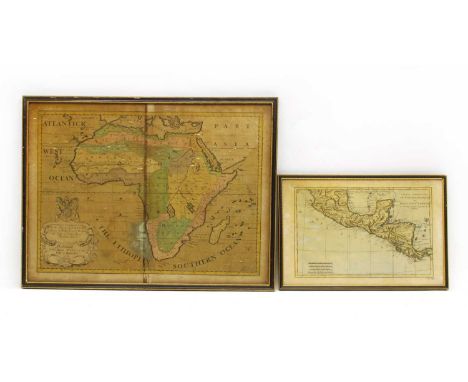
A hand coloured map of Africa after Edward Wells, c.1700, 'A New Map of Africk Shewing its Present General Divisions, Chief Cities or Towns, Rivers, Mountains & c, Dedicated to His Highness William Duke of Gloucester', engraved by R Spofforth, 41 x 54cm, together with a smaller example, 'Partie Meridionale De L'Ancien Mexique ou De La Nouvelle Espagne' (2)Condition report: The former in generally poor condition, with discolouration a mark down the centre, as well as a crease to the centrefold. Some staining, marks and foxing to both.


Lot 3212
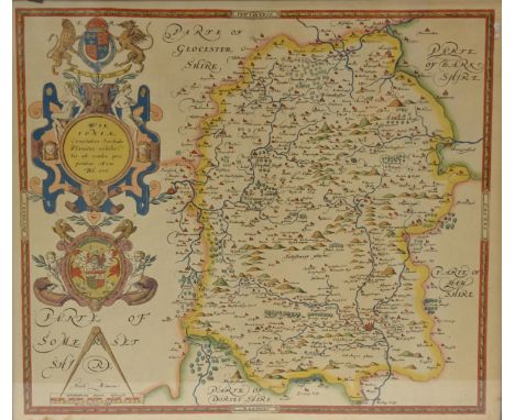
John Speed (1552-1629)(Cardiganshire) Cardigan Shyre described with the due forme of the Shire town as it was surveyed by J. S. Anno 1610 hand coloured engraved map(damage and folds to paper, foxing)Provenance: from the Estate of the late Sir John and Lady Harvey Jones (Sir John Harvey Jones MBE)

Lot 3222
Coloured engraving depicting "Dominio Veneto nell` Italia" (Northern Italy), circa 1640 illustrating the region of Venice and region extending west with extensive river system throughout the map, with Venetian arms top left (damage and staining top left and central sections)Provenance: from the Estate of the late Sir John and Lady Harvey Jones (Sir John Harvey Jones MBE)

Lot 3266
Michael Crawley, Dovedale Derbyshire, signed and titled watercolour, 21cm x 25cm; Michael Crawley, Dew Pong nr Bakewell, signed watercolour, 26cm x 36cm; coloured engraving by Hay, after Carter, Croxden Abbey; after John Speed, map of Stafford Countie and Town; early Victorian watercolour of a girl in green dress, signed and dated Martin 1852; mezzotint of Lady Elizabeth Lee, signed in pencil Clifford Lee; etc (7)

Lot 3277
C Faulkner, late 19th Century, Horse pulling a hay stack meeting another horse, the boy drinking on top of the haystack and the dog in the corner barking, oil on board, fitted in a gilt frame, together with an early 20th Century oil on canvas, depicting a table top study, a watercolour depicting a lead miner, a reproduction map of Nottinghamshire, a watercolour depicting a rural landscape (5)


Lot 304
Two Antiquarium maps, plan of the harbours of Port Lewis and Laurent, and the geometrical survey of the Gulf of Naples, the first printed by W. Faden, of Charring Cross, June 1st 1793, 35 cm x 22 cm. Together with a small antique style map of Macedonia. CONDITION REPORT: Some slight discolouration to the two main maps and fading, some crease marks.


Lot 127
Original vintage advertising poster issued by Siera company titled Holland - A Name in Communication,with an artwork featuring the world map, with four portraits of famous inventors in telecommunications at the bottom - Edison, Marconi, Poulsen, and Baird. The sides of the poster are decorated with other telecommunication devices, and is surrounded by flags of nations across the world. Good condition, creasing, tears. Country of issue: Netherlands, designer: Unknown, size (cm): 77x101, year of printing: 1968

Lot 156
Original vintage poster titled in French "Carte De La Lune" - "Map of the Moon", with an artwork featuring two intricate and detailed illustration of both the visible and the dark side of the moon, with named features such as craters and mountains. A small image at the top right corner shows a map of Europe, labelled "surface de l'Europ comparee a celle du disque de la lune" - surface of Europe compared to that of the moon's disk". The top left features a small diagram showing different moon phases. Very good condition, staining in margins, minor creasing in margins. Country of issue: France, designer: Unknown, size (cm): 76x130, year of printing: 1970s

Lot 171
Original vintage travel poster for Ypres, a Belgian municipality in the province of West Flanders. The artwork, buy artist Selly, features the ruins of St Martin's Cathedral, and a small map of the surrounding areas beneath, including locations of ruins, battlefields and cemeteries. Ypres is commonly known for the Battle of Ypres in World War One, between the Axis and Allied Forces. Printed in Brussels, Belgium. Good condition, folds, creasing, staining, tears. Country of issue: Belgium, designer: Selly, size (cm): 101x63, year of printing: 1920s

Lot 187
Original vintage travel advertising poster, with a pictorial map by Swedish artist Ernst Akerbladh (1890-1969), and captioned A map of Saltsjobaden, in the archipelago, half an hours trip from Stockholm, the 7 centuries old capital of Sweden, and the illustration showing a compass, and colourful drawings of the landmarks and various activities available, such as skiing, photography, rowing, picniking, fishing, swimming, sailing, skinny dipping, hiking, and tennis. Decorated with a bust of Poseidon with a trident at the bottom right. Printed by Haeggstrom Litho, Stockholm, Sweden. Good condition, foxing, creasing, small tears. Country of issue: Sweden, designer: Ernst Akerbladh, size (cm): 100x69, year of printing: 1930s

Lot 211
Original vintage poster issued by The National Geographic Magazine featuring a map of the British Isles with an Illustrated border which includes notable British figures from history such as William Shakespeare and Charles Darwin, national sports and traditions for Engalnd, Ireland, Scotland and Wales, coats of arms for London, Belfast, Edinburgh, Cardiff and Dublin. Printed by A. Hoen and Co Baltimore USA. Good condition, folds, minor staining, small paper loss on fold. Country of issue: USA, designer: C.E Riddiford, size (cm): 92x76, year of printing: 1937

Lot 216
Original vintage travel poster for Jersey featuring a colourful pictorial map of the largest of the Channel Islands located between England and France showing a map of the roads, sandy beaches, people enjoying water sports, horse riding, ships at sea, fishing, hotels, flag and coat of arms, compass, a cherub on a cloud, lighthouse etc. with places of interest and distances marked. Horizontal. Good condition, tears, creasing, folds, minor staining at the bottom. Country of issue: UK, designer: F. Mahon-Brown, size (cm): 56.5x80, year of printing: 1948

Lot 261
Original vintage travel poster advertising Dominican Republic International Fair 1956 - Land of Discovery - Great design features multicoloured lights shining out from the fair which is positioned on a map of the Dominican Republic. Good condition, paper loss at bottom left corner, creasing, discolouration at right margin. Country of issue: Dominican Republic., designer: L. Emmerich, size (cm): 73x53, year of printing: 1956

Lot 263
Original vintage travel poster featuring an annotated map of Dartmoor National Park featuring travel routes, roads, railways, youth hostels, place names, camping areas, golf courses, fishing location, horse riding and sailing areas. More detailed illustrations and descriptions surround the main map. Printed in England by her Majestys Stationary Office press, Manor Farm. Dartmoor is an upland area in southern Devon, England. The moorland and surrounding land has been protected by National Park status since 1951. Dartmoor National Park covers 954 km2 (368 sq mi). Poor condition, folds, tears, staining, pinholes, paper losses in corners. Country of issue: UK, designer: Reitz, size (cm): 75x50, year of printing: 1963

Lot 264
Original vintage travel poster featuring an annotated map of The North York Moors National Park featuring travel routes, roads, railways, youth hostels, place names, camping areas, golf courses, fishing location, horse riding and sailing areas. More detailed illustrations and descriptions surround the main map. Printed in England by her Majestys Stationary Office press, Manor Farm. The North York Moors is an upland area in North Yorkshire, England, containing one of the largest expanses of heather moorland in the United Kingdom. The North York Moors National Park was designated in 1952, through the National Parks and Access to the Countryside Act 1949. The National Park covers an area of 554 sq mi (1,430 km2), and has a population of 23,380. It is administered by the North York Moors National Park Authority, whose head office is based in Helmsley. Good condition, folds, tears, staining, creasing. Country of issue: UK, designer: Reitz, size (cm): 75.5x49.5, year of printing: 1963

Lot 266
Original vintage travel poster featuring an illustrated map of the Yorkshire Dales, as part of the National Parks.The hiking map contains images of various places of interest in the area, including the view of Swaledale, Malham Cove, Bolton Priory, Wharfedale. Prepared for the countryside commission by the Central Office of Information. Printed in England by Her Majesty's Stationery Office Press, Manor Farm. The Yorkshire Dales is an upland area of the Pennines in the historic county of Yorkshire, England, most of it in the Yorkshire Dales National Park created in 1954. Good condition, pinholes, staining, small tears, foxing. Country of issue: UK, designer: Reitz, size (cm): 75x50, year of printing: 1968
Lot 270
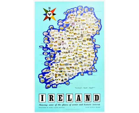
Original vintage travel poster of an illustrated map of Ireland, with images showing various places of interest across the entire map, such as Reginald's Tower, Waterford, Kilconnell Abbey, Legananny Dolmen, Drogheda, Roscommon Castle, and many more. Subtitled Showing some of the places of scenic and historic interest, with a light blue background, and published by the Irish Tourist Board. Printed in the Republic of Ireland by Browne & Nolan Limited, Dublin. Very good condition, minor creasing, Country of issue: Ireland, designer: Unknown, size (cm): 101x64, year of printing: 1960s
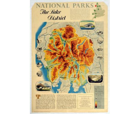
Lot 282
Original vintage travel poster featuring an annotated map of The Lake District National Park featuring travel routes, roads, railways, youth hostels, place names, camping areas, golf courses, fishing location, horse riding and sailing areas. More detailed illustrations and descriptions surround the main map. Printed in England for her Majestys Stationary Office by Taylor Garnett Evans and Co LTD. Good condition, pinholes, paper losses on corners, tears, creasing, staining at top. Country of issue: UK, designer: Reitz, size (cm): 73.5x51, year of printing: 1960s

Lot 291
Original vintage travel advertising published by Intourist, and titled in bold red lettering, "Visit the USSR", with a map of cities surrounding Moscow, and marked "Cities in which Intourist services are available." The cities include Leningrad, Vilnius, Minsk, Kiev, Krasnodar, Volgograd, and more. The three seas - Baltic Sea, Black Sea, and the Caspian Sea. Intourist was founded on April 12, 1929 and served as the primary travel agency for foreign tourists in the Soviet Union. Poor condition, creasing, tears, paper losses, staining. Country of issue: Russia, designer: Unknown, size (cm): 99x60, year of printing: 1970s
Lot 325
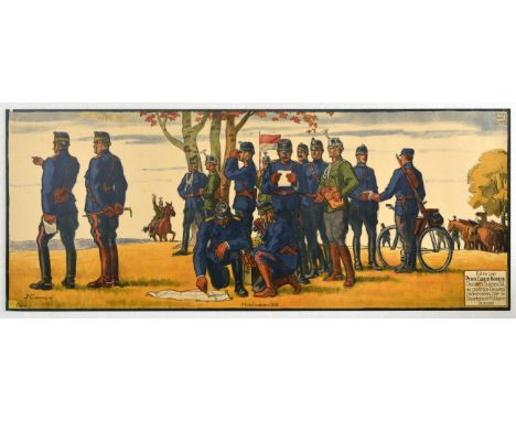
Original vintage propaganda poster Mobilisation 1914 - Map Reading - Great artwork by Jules Courvoisier (1884-1936) features soldiers in blue uniform standing in a group some analysing a map , one looking through binoculars and another with a bike passing a note. Soldiers on horesback in the background. Edited by Peter Cailler Kohler Swiss Chocolates SA for the benefit of the Works sponsored by the Swiss Military Department / Edite par Peter Cailler Kohler Chocolats Suisse SA au profit des Oeuvres patronnees par le Department Militaire Suisse. Good condition, tears, small paper loss at top left, restored paper loss at bottom left, pinholes, staining. Country of issue: Switzerland, designer: Jules Courvoisier , size (cm): 40x100, year of printing: 1916
Lot 339
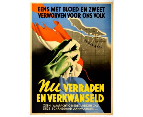
Original vintage Dutch propaganda poster titled in Dutch Eens met bloed en zweet verworven voor ons volk, nu verraden en verkswanseld - Geen waarachtig nederlander zal deze schanddaad aanvaarden... - Once acquired with blood and sweat for our people, now betrayed and squandered - No true Dutch person will accept this disgrace ..., with an artwork of a green hand tearing a Netherlands flag and revealing the map of Curacao and Suriname. Poster was issued by the Nationalist Socialist Party in teh Netherlands. The National Socialist Movement in the Netherlands - NSB was a Dutch fascist and later Nazi political party that called itself a “movement”. As a parliamentary party participating in legislative elections, the NSB had some success during the 1930s. Under German occupation, it remained the only legal party in the Netherlands during most of the Second World War. Good condition, folds, minor creasing, minor staining, repaired tears. Country of issue: Netherlands, designer: Unknown, size (cm): 82x60, year of printing: 1941
Lot 347
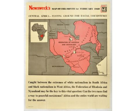
Original vintage propaganda poster published by Newsweek - map-of-the-month, titled Central Africa-Testing Ground For Racial Coexistence, with a map featuring the Federation fo Rhodesia and Nyasaland. Printed in the USA. Good condition, folds, pinholes, minor staining. Country of issue: USA, designer: Mogill, size (cm): 114x90, year of printing: 1960
Lot 354
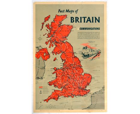
Original vintage map poster Fact Maps of Britain - Communications - Great artwork features an annotated map of The United Kingdom with key railways and roads marked - Prepared for the British Information Services by the Central Office of Information. Printed in England for HM Stationary Office by Fosh and Cross Ltd London. Acceptable condition, tears, small paper losses, minor staining, minor creasing. Country of issue: UK, designer: Unknown, size (cm): 76x51, year of printing: 1962
Lot 355
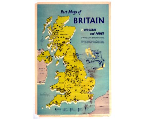
Original vintage map poster Fact Maps of Britain Industry and Power - Great artwork features an annotated map of The United Kingdom with symbols to show the location of British Industries - Prepared for the British Information Services by the Central Office of Information. Printed in England for HM Stationary Office by Fosh and Cross Ltd London. Poor condition, staining, tears, paper losses at corners, creasing. Country of issue: UK, designer: Unknown, size (cm): 76x51, year of printing: 1962
Lot 362
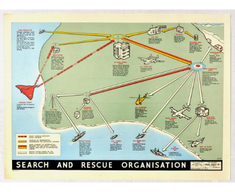
Original vintage propaganda poster titled Search and Rescue Organisation, produced By command of the Defence Council, for use in the Royal Navy/ Royal Air Force, Prepared by the Ministry of Technology. The artwork features a coastal map of a search and rescue operations diagram, with an orange plane, helicopters, merchant ship, lifeboat, and coastguard. Horizontal. Excellent condition, minor creasing. Country of issue: UK, designer: ATP, size (cm): 56x76, year of printing: 1967

Lot 435
Original vintage propaganda poster with an artwork featuring a cariacture cartoon of Adolf Hitler and three other Nazi generals confronted by a Mexican man wearing a sombrero, dressed in white with a holster holding a revolver and rounds of ammunition, with a drawn map of South America in the background. The artwork is by Mexican artist Antonio Arias Bernal, also known as The Brigadier, an important Mexican caricaturist and cartoonist of the twentieth century known for his work during World War 2. Excellent condition, minor creasing, small tear at bottom left. Country of issue: Mexico, designer: Arias Bernal, size (cm): 51x35.5, year of printing: 1940s
Lot 440
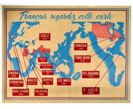
Original vintage Second World War propaganda poster issued in the Nazi occupied France and aimed at sturring anti- British sentiment in the population. Title in French reads: Francais regardez cette carte - French look at this map, with an artwork showing the world map and British colonies highlighted in pink, and years of conquering, including the Suez 1874, Canada 1765, India 1765, Egypt 1801, and St. Lucia 1803. Horizontal. Good condition, tears, creasing, fold. Country of issue: France, designer: Unknown, size (cm): 79.5x60, year of printing: 1940s

Lot 496
Original vintage ski poster titled Cervinia and Valtournenche, with a landscape map showing various ski routes along the Cervinia mountains, marked in red lines, as well as the altitude of the mountain peaks. Horizontal. Good condition, minor staining, small paper loss at top left corner. Country of issue: Italy, designer: Moss, size (cm): 97x68, year of printing: 1970s

Lot 497
Original vintage ski poster titled Cervinia and Valtournenche, with a landscape map showing various ski routes along the Cervinia mountains, marked in red lines, as well as the altitude of the mountain peaks. Horizontal. Excellent condition, minor creasing. Country of issue: Italy, designer: Moss, size (cm): 97x68, year of printing: 1970s

Lot 56
Original vintage exhibition advertising poster titled in Czech Vystava 38 Nachod 19 Cervna 15 Srpna - Exhibition 38 Nachod 19 June 15 August, with an artwork by Ant. Brunner, featuring an illustration of a young girl with inviting arms, next to a small basket of fruit including pears and apples, against the background of a map, castle, and coat of arms with a lion. Printed in Prague, Czech Republic. Good condition, creasing, staining, backed on linen. Country of issue: Czech Republic, designer: Ant. Brunner, size (cm): 93x61, year of printing: 1938

Lot 11
Teil eines Kartenwerks, 17.Jh. - Sanson d' Abbeville, "Die ganze Erdkugel bestehend in den vier bekannten Teilen der Welt als Europa, Asia, Africa und America samt schönen neuen und akuraten Landkarten (...)", Frankfurt am Main 1679.Textband ohne Landkarten. Nicolas Sanson d'Abbeville war ein überaus renommierter französischer Kartograph. Handschriftliche Einträge, Wurmlöcher, Flecke, Verfärbungen, Knicke, erkennbare Alters- und Gebrauchsspuren. Part of a map series, 17th cent. - Sanson d' Abbeville, "The whole globe consisting in the four known parts of the world as Europe, Asia, Africa and America together with beautiful new and accurate maps (...)", Frankfurt am Main 1679.Text volume without maps. Nicolas Sanson d'Abbeville was an renowned French cartographer. Handwritten entries, wormholes, stains, discolourations, creases, visible signs of age and usage.


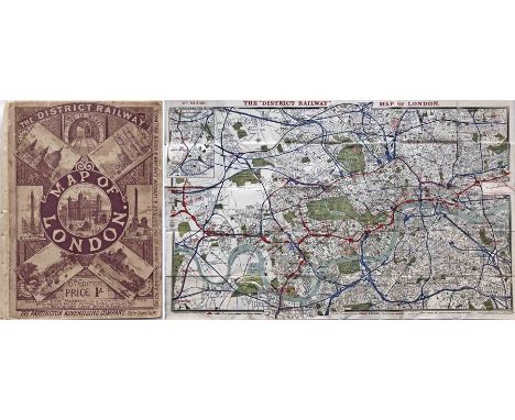
Lot 166
The "District Railway MAP of London', 6th edition, circa 1903. The 3rd issue of this edition. An inset states that the 'New Route to Upminster, Shoeburyness etc is now open". Some of the first tube lines are now included, either open, authorised or under construction. The proposed, but later abandoned, City & Brixton tube railway is still shown but now terminating south of the River. Opens out to 42" x 26" (107cm x 65cm). An unusually fine copy in very good order, even the covers evidence only light wear. [1]

Lot 18
1923 London Underground MAP of the Electric Railways of London "What to see and how to travel". Designed by MacDonald Gill with his distinctive style of calligraphy and map border, this is the issue dated 1/1/23 and the version thereof which shows the British Empire Exhibition stations with red dots. Lightly-used with a little creasing, a small edge-loss and a couple of age-spots but overall a good example. [1]
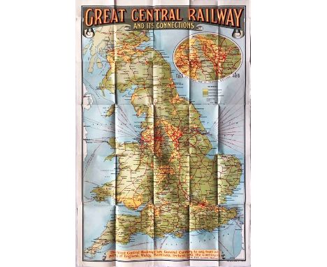
Lot 202
c1910-15 POSTER MAP 'Great Central Railway and its Connections' with an inset enlarged-scale map of central England. Covers England and Scotland as far as Perth & Dundee. Shows ferry services to Ireland & the Continent as well as manufacturing & agricultural districts, upland, moorland & pasture. Strong, vibrant colours make this a very attractive map. Measures 26" x 39" (66cm x 100cm) and is generally in very good condition with very light wear. Folded. [1]

Lot 214
1970 (print-code 11/69) London Underground quad-royal POSTER MAP designed by Paul Garbutt and still with the traditional border of small bullseyes. Interchange stations are in upper case, the remainder in lower. Shows the Victoria Line extension to Brixton as 'under construction'. A couple of very small edge-losses and some general creasing and crumpling from having previously been rolled rather tightly but still presents well. [1]

Lot 222
c1910-15 Great Central Railway COLLIERY & INDUSTRIAL MAP. Shows agricultural land, manufacturing areas, proved & concealed coalfields and collieries to which the company's lines have access. Strong colours make this an attractive map. Paper, single-sided, measures 38" x 29" (97cm x 74cm) and is generally in very good condition. Folded. [1]
-
109182 item(s)/page