

Southeast Asia.- Laurie & Whittle (publishers) A New Chart of the Banda Sea, Including The Isles of Amboyna, and Banda, Those of Bouro, Ceram and The Circumjacent Islands, detailed chart with inset maps of the Bay of Amboyna and Islands of Banda, Goonong-Appee and Banda Neira, engraving on thick laid paper without watermark, sheet 470 x 630 mm (18 1/2 x 24 3/4 in), some off-setting and minor toning, old fold to lower edge with splitting repaired verso, unframed, 1799; together with 2 others of the region, including J. v.d. Bosch's 'Kaart der Bandasche Eilanden' from the Atlas der Overzeesche Bezittingen, and a lithographed map with the title 'Kaart van het Eiland Timor... 1847' by C.Franz, 360 x 520 mm (14 1/4 x 20 1/2 in) and 360 x 490 mm (14 1/4 x 19 1/4 in), respectively, unframed, 19th century (3)
We found 109198 price guide item(s) matching your search
There are 109198 lots that match your search criteria. Subscribe now to get instant access to the full price guide service.
Click here to subscribe- List
- Grid
-
109198 item(s)/page

Indonesia.- Java.- Chatelain (Henri Abraham) Carte de l'Ile de Java: Partie Occidentale, Partie Orientale. Dressee Tout Nouvellement sur les Memoires les Plus Exacts, large-scale chart of the island of Java, inset map in the lower left showing harbour and plan of Batavia, present day Jakarta, numerous text descriptions surrounding the map, engraving with fine early hand-colouring, on two sheets of laid paper conjoined, platemark 380 x 865 mm (15 x 34 in), sheet 445 x 1000 mm (17 1/2 x 39 1/2 in), old folds as issued, minor handling creases, some faint surface dirt and light toning, one or two small marginal nicks, unframed, 1719.
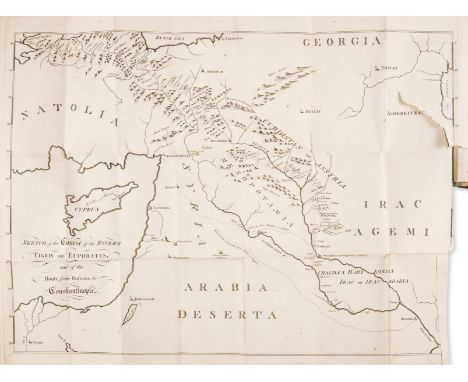
Middle East.- Howel (Thomas) A Journal of the Passage from India, by a Route partly unfrequented, through Mesopotamia, Armenia, and Natolia, or Asia Minor, first edition, large folding engraved map frontispiece with a few tears, final leaf with lower corner torn away, just touching the word "finis", occasional foxing, pencil annotations, uncut in original boards, worn, [Ghani p.181], 8vo, Printed for the author, [1789].⁂ Rare first edition of an account of Howel's year-long journey returning to England from India in 1787, up the Persian Gulf and the Euphrates and thence overland from Baghdad to Constantinople.
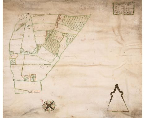
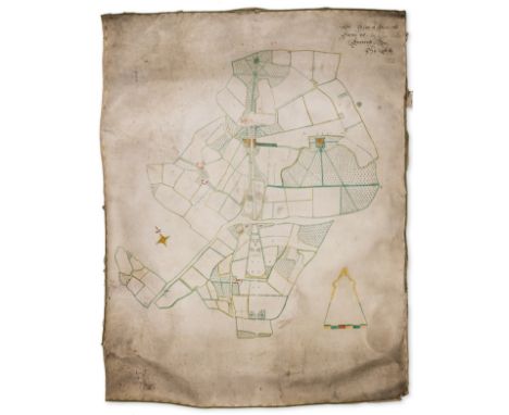
Wiltshire Estate Map.- Joliffe (Richard, Surveyor) A Mapp of Milkhills, Belonging to Robt. Eyre Esqr. of New-House, In the County of Wilts, manuscript estate map of land near Redlynch, title in the upper right quadrant, compass rose in the lower left corner, north oriented to the upper left, scale in the lower right corner, pen and ink, watercolour wash, numerous ink and pencil annotations, all within a green and white watercolour wash border, on vellum, 755 x 835 mm (29 3/4 x 32 3/4 in), some creasing, small marginal losses and pinholes, minor surface dirt and old damp-stains, mainly marginal, unframed, [circa 1730s]

British Isles.- Speed (John) [England Wales Scotland and Ireland Described and Abridged. With ye historic relation of things worthy memory from a farr larger voulume], lacking engraved title, 62 uncoloured engraved maps only (of 63), by Pieter Van den Keere, including one folding (British Isles), lacking Yorkshire, text leaf opposite folding map of British Isles with surface dirt and heavy restoration recto and verso, bound in the wrong way round, the folding map with browning and minor stains, the upper right corner with loss restored, some occasional surface dirt and minor browning, minor nicks, a few leaves with stains, later endpapers with owner inscription and red ink stamp of the poet John Drinkwater, dated 1917, modern calf, oblong 8vo, [George Humble, circa 1627-1631]

Vietnam.- Boucher (Lucien) France Indochine, decorative map of French Indochina, illustrated with vignettes of Angkor Wat, Pnom-Penh and Saigon, and numerous animals including elephants, lions, monkeys, and sea monsters, lithograph printed in colours, on wove paper, sheet 995 x 660 mm (39 1/4 x 26 in), mounted onto conservation support, some minor handling creases, unframed, éditée par l'Association nationale pour l'Indochine Française, [circa 1945-46]
Newhouse, Wiltshire Estate Map.- Joliffe (Richard, Surveyor), attributed to. A Plan of Newhouse Farme, very large manuscript estate map, title in the upper right quadrant, compass rose in the lower left corner, north oriented to the upper left, scale in the lower left corner, pen and ink, watercolour wash, numerous ink and pencil annotations, all within a red and yellow watercolour wash border, on two sheets of vellum conjoined, 1310 x 1070 mm (51 1/2 x 42 in), mounted on conservation support, some creasing, marginal losses and other losses carefully replaced in facsimile, some surface dirt and old damp-stains, mainly marginal, unframed, 1734⁂ Monumental estate map.
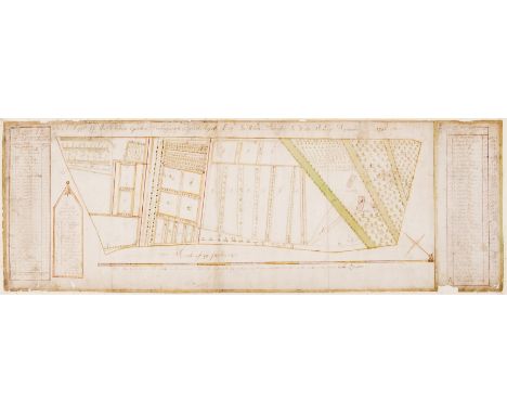
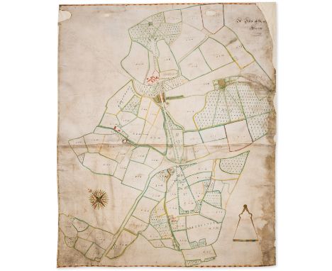
Lost Gardens of Newhouse.- Anonymous (English surveyor, active circa 1740s) A Mapp of the Kichen Gardens Belonging to Robert Eyre Esq. In White Parrish in Wilts. Survey'd September 1746, detailed map of the 18th century working kitchen gardens of Newhouse Estate, on 'a scale of 40 perches', with two columns to the left and right margins identifying details within the garden, mainly 'Fruit hedges', with a separate key identifying 'The Partes of the Garden and their names with the marks', which includes separate sections for asparagus, artichoke, raspberry, cherry, melon, and 'The bee garden', amongst others, pen and brown ink with watercolour, on three sheets of laid paper conjoined, total sheet 330 x 950 mm (13 x 37 1/2 in), mounted onto conservation paper support, some small losses, mainly to extremities, old handling creases, surface dirt, unframed, 1746Provenance:Newhouse Estate;Then by descent to the present owners ⁂ Rare 18th century record of a now lost garden, specifically the "Kichen" garden of Newhouse, Wiltshire. Executed by an unrecorded surveyor on behalf of Robert Eyre (c.1693-1752), the eldest son of Sir Robert Eyre, MP, of Newhouse, and his wife Elizabeth Rudge, daughter of Edward Rudge of Warley, Essex.
India.- Crawfurd (John) Journal of an Embassy from the Governor-General of India to the Court of Ava, in the Year 1827... With an Appendix, Containing the Description of Fossil Remains, by Professor Buckland and Mr. Clift, first edition, half-title, 5 aquatint plates, of which 3 hand-coloured, 5 lithographed plates, folding engraved map (light off-setting, and small hole at fold), folding engraved plan, wood-engraved illustrations, some light foxing to plates, map and plan, original boards with paper label to spine, lower joint broken with upper cover and back-strip (together) detached, small chips to label and spine ends, [Abbey Travel 405], 4to, Henry Colburn, 1829.
Newhouse, Wiltshire Estate Map.- Joliffe (Richard, Surveyor) A Map of Newhouse Farme &c., In Com. Wilts., manuscript estate map of Newhouse and its environs, title in the upper right quadrant, compass rose in the lower left quadrant, north oriented to the upper left, scale in the lower right corner, pen and ink, watercolour wash, numerous ink and pencil annotations, on vellum, 1150 x 900 mm (51 1/2 x 42 in), mounted on linen, remnants of green silk edging, heavy creasing, surface dirt, spotting, and old damp-stains, unframed, 1731
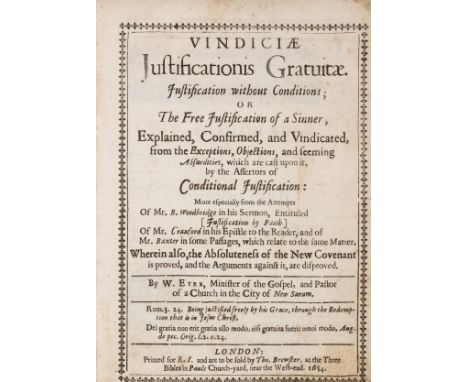
Eyre (William) Vindiciae Justificationis Gratuitae. Justification without Conditions; of The Free Justification of a Sinner, Explained, Confirmed, and Vindicated, Reader note opposite title, title within typographical border, letter loosely inserted sending the vol. to Matcham, slightly browned, a few ff. with slight staining in margins, a few brown marks, front free endpaper corner torn away, contemporary calf, scratched, edges rubbed, lacks head and tail of spine, [Wing E3947], for R. I. and... Tho. Brewster, 1654 § Leigh (Edward) The History of the Twelve Caesars, p. 109 to end slight worming in upper margin, slightly browned, contemporary calf-backed boards, rubbed, lower cover detaching, Paisley, J. Weir, 1791 § Jackson (Rev. J.E.) Wulfhall and the Seymours, presentation copy from the author to George Matcham, frontispiece and map, manuscript inscription on title "Privately Printed", original morocco-backed boards, 1874; and c. 17 others from the Matcham Library, v.s., v.d. (c. 20).

A quantity of decorative contemporary ceramics to include an art potter jug with potters seal impressed mark; various Poole pottery items to include Poole map plate; a modern print of a still life of a chair; a Victorian vase; glass bowl; a pair of cream glazed pottery wall brackets; etc (qty)All in generally good condition. The Victorian vase with wear to the gilding.


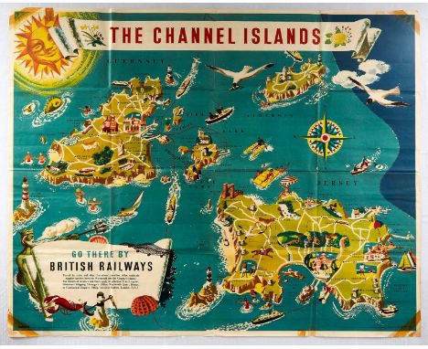
Original vintage travel advertising poster for The Channel Islands - Go there by British Railways published by the Southern Region of British Railways, colourful illustrated map of the Channel Islands depicting Guernsey, Alderney, Sark and Jersey with the various transport services, attractions and activities marked, including the ferry services between Weymouth and the islands, golf and race courses, castles, churches, sailing boats, lighthouses and people sunbathing, swimming and fishing with seagulls flying overhead, a decorative sun and the title banner decorated with flowers at the top, and a compass and image of Poseidon above the information text - Travel by train and ship - in a parchment style banner below. Printed in Great Britain by Jordison & Co., Ltd., London & Middlesbrough, designer: Frederick Griffin, Large size. Horizontal / landscape, 49½ x 40in. (25.8 x 101.4cm.). * Condition: fair / poor condition, folds, tears, tape marks stains, pinholes, small paper loss in margin, creasing, etc.
Dugdale (Sir William), The Antiquities of Warwickshire, Illustrated from Records, Leiger Books, Manuscripts, Charters, Evidences, Tombes, and Armes, Beautified with Maps, Prospects and Portraitures, pub. London, Thomas Warren 1656, engraved portrait frontispiece by Wenceslaus Hollar (trimmed and mounted on blank leaf) with further portrait engraving of Hollar mounted to blank leaf after title, 5 double-page engraved maps, six double page engravings and engraved illustrations throughout, many full-page, errata leaf at end, later half calf with combed marbled boards, folio, not collated, faults. * Condition: Binding at fault - cover detached, back cover cracked, worn. Later front and back end papers. Light spotting and toning throughout, heavier spotting and toning to title, index, errata and end papers. Contemp. ink ownership inscription to back of title. A few ink stains. Tear to 50% of fold on first folding map (Knightlow Hundred). One double page engraving re-backed. Some paper repairs to edges.

A map of the Island of Guernsey, by James Cochrane Junior 1832, dedicated to Lord de Saumarez, Vice Admiral of Great Britain, with vignette of the Royal College of Elizabeth, 22 x 27in (56 x 68.5cm.), framed and mounted, numbered 246/250; together with Carte de L'Isle de Grenesey, chart showing Guernsey and the smaller islands, photographic print after Jacques Nicolas Bellin, modern. (2)

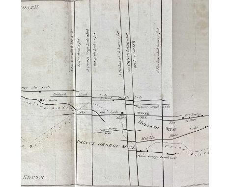
Rev. Malachy Hitchins Account of the discovery of silver in Herland Copper Mine (near Gwennap) Communicated by Sir Joseph Banks on the 12th February, 1801. First edition, 1800, published by the Royal Society of London. Herland Mine is believed to have started in 1717 and runs contiguous to Prince George Mine. In 1726, the mine was rich enough to have a 70-inch Newcombe Pumping Engine and was developed to 120 fathoms. 6 pages plus a fold-out map showing the lodes of Herland and Prince George Copper Mines on a plane parallel to the horizon at one hundred and ten fathoms below the surface of the earth. Good condition.

Robert Sawle Donnall. 'The Trial of Robert Sawle Donnall,' 'Surgeon and Apothecary, Late of Falmouth in the County of Cornwall, For The Wilful Murder, by Poison of Mrs Elizabeth Downing, Widow, His Mother-in-Law at the Assizes at Launceston, For The County aforesaid, On Monday, March 31st 1817, Before the Honourable Sir Charles Abbot. Taken in Short-Hand by Alexander Frazer, 27, Thavies Inn, London,' engraved map/plan of the tea room (opposite page 26), 179 pages untrimmed, in original paper boards, first edition, a very good if not fine copy, printed by and for James Lake, Falmouth, 1817.

'The Cambrian Archaeological Association'. Truro meeting, 1862 programme, bound with a list of antiquities in the Hundreds of Kerrier and Penwith, West Cornwal, with references to the works in which they are described and figured, arranged with an illustrated appendix by J. T. Blight, including a fold out map of Bodmin and Liskeard district, published by James R. Netherton, Truro, 1862.Bound with;William Jory Henwood. 'Notice of the Rock-Basons at Deo (Devi) Dhoora,' reprinted from the Report of the Royal Institution of Cornwall, 4 pages.'Report of the Sixteenth Annual Meeting of the Cambrianarchaeological Ass. held at Truro August 25th-30th 1862,' published by J. Russell Smith, London, 72 pages.'Views of the Antiquities of Wales and the Marches with Some in Cornwall and Brittany Extracted from the Archaeologia Cambrensis,' 1862, 66 engraved plates.Additionally tipped in many plans and drawings. A good copy. (1)
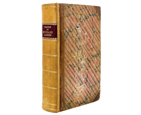
Robert Huish Esq. 'The Travels of Richard Lander into the Interior of Africa for the Discovery of the Course of the River Niger, from the Unpublished Documents in the Possession of the Late Capt John William Barber Fullerton Employed in the African service,' Tipped in is a signed note by Richard Lander 'am my dear sister ever affectionately yours R. L. Lander', first edition, frontispiece portrait, lithograph title page, map and 6 plates, 8vo, 782 pages, a fine copy, published by John Saunders, 25 Newgate St, London, 1835.Richard Lemon Lander was born in the Fighting Cocks Inn, Truro (now the Dolphin Inn) and educated at ‘’Old Pascoes’’ Truro, before joining a wealthy London family and travelling to Africa, with a prefatory analysis of the journeys Park, Denham, Clapperton this work contains accounts of Richard landers three expeditions through Africa. Lander will always be associated with the exploration of The Niger.

Thomas Tonkin (Francis Lord de Dunstanville edition). 'Carew’s Survey of Cornwall,' 'To Which are Added Notes Illustrative of its History and Antiquities, Now First Published from the Original Manuscripts by Francis Lord de Dunstanville. A Journal or Minutes of the Convocation or Parliament of Tinners for the Stannaries of Cornwall held at Truro in the year 1710. The Grant of the Sheriffalty to Edward, Duke of Cornwall,' second edition, published by J. Faulder, London, 1811, tipped into this work are the following letters:May 26th 1821, Upper Grosvenor from De Dunstanville relating to his friend 'Davies Gilbert'.May 29th 1821, London from De Dunstanville to J. W. Croker (John Wilson Croker Secretary to the Admiralty, M. P. for Bodmin 1820-1826, contributor to the quarterly magazine).June 1821, Upper Grosvenor from De Dunstanville relating to Mr Pascoe.July 27th 1886, Bodmin from Joseph Polsue to an unknown recipient.1812 signed note by De Dunstanville.This copy is 'extra-illustrated' with 87 plates, 5 plates drawn by J. M. W. Turner/4 by Farington/5 double page plates by S & M Buck/9 hand coloured Allom’s etc. County map. This is the 'Tonkin' edition which is widely regarded as the most comprehensive edition. The front board is loose but the contents are in an almost fine condition. gilt embossed spine blue boards.

Rev. Daniel Lysons & Samuel Lysons. 'Magna Britannia, a Concise Topographical Account of Cornwall'. Volume III, first edition, foli, large paper copy, folding coloured map, 37 plates, extra illustrated with 24 fine full engraved views from Farringdons Britannia Depicta, full cont gilt tooled calf morocco, a very good, if not nearly fine copy, Strahan & Preston for T.Cadell and W.Davies, 1814.

Geology Interest Harvey Buchanan Holl 'On the older rocks of South Devon and East Cornwall' From the quarterly journal of the Geological Society, 54 pages with a cloth geological map of South Devon & East Cornwall at the back, stamp of the Newport Free Library, bound in brown hardback boards, first edition, 1868.Harvey Holl, at the age of 17, trained under Sir Henry De La Beche, laterly training as a surgeon. Returning to geology later in life, he wrote many accomplanished papers for The Geological Society. This paper exemplified the excellence in method of his early teacher in Geology, De La Beche. scarce.


Harold E. Fern Cornish Chamber of Mines Year Book, 1920 Published by the Cornish Chamber of Mines, original octavo cloth bords, gilt title to front board and spine, 111 pages with engravings, 3 folding tables, and a large folding map showing the situation of the mines in cornwall. Bookplate of John Blowey, first edition. A very good copy.

Richard Edmonds. 'The Lands End District. Its Antiquities, Natural History', 1862. 'Natural Phenomena and Scenery. Also a Brief Memoir of Richard Trevithick,' first edition, 270 pages with 6 plates and fold out map, several woodcuts, publishers catalogue to rear, tipped in letter at page 242 dated 1869 and signed by A. R. Cornish (?) and Boase, plus newspaper cuttings and notes in original rebacked boards, a good copy, by F. T. Vibert, Penzance, 1862.Richard Edmonds (Late of Penzance) Secretary for Cornwall to the Cambrian Archaeological Association.


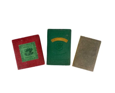
Guides to Cornwall. 'Besleys Views of Cornwall,' 6 engravings, circa 1860, in original boards, a very good copy with the bookplate of John Blowey.C. A. Dawson Scott. 'Nooks and Corners of Old Cornwall,' circa 1900, first edition, pub by Eveleigh Nash, London, with map tucked into pocket at back, a fine copy.'Netherton & Worth’s Guide to Cornwall. Being a Tourist Guide to Cornwall and the Scilly Isles,' by Annie A. Argall, 1900, first edition, a very good copy in original boards. (3)

Fowey interest. Mabel Lucy Attwell. 'Fowey. The Centre of the Cornish Riviera,' 64 pages incl map, intro by Daphne du Maurier, being a guide of Fowey and environs, Jory & Son, Fowey, circa 1966.'Drives from Fowey by The AA,' circa 1940s, 15 pages.'Fowey Cottage Hospital Bazaar Programme,' august 1899.'The Riviera of the West Fowey, Wornwall,' circa 1900, 44 pages. (4)

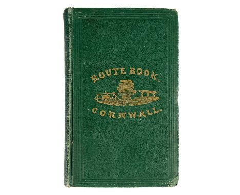
Henry Besley. 'The Route Book of Cornwall'. 'A Guide for the Stranger & Tourist to the Towns and Other Interesting Localities of the County with Maps and Embellishments,' first edition, 6 folding maps of the routes, folding map of the county (interestingly with 19 vignette engravings, more than the ones listed.), in original green binding with gilt lettering to spine and front cover, a good copy, published by Besley, circa 1860.
Three maps of Cornwall. William Westcott Rundell (Falmouth). 'Cornwall,' inset map of the Scilly Isles, laid on linen, a rare map of Cornwall, William Rundell does not appear in 'Worms and Baynton Williams British Map Engravers, published by W. Wood, Fore St, Devonport.'Map of the County of Cornwall Divided into Hundreds Containing the District Divisions and Other Local Arrangements,' cloth backed by Edward Stanford, Charing Cross, [circa 1880].Philips New Series of County Maps from the Ordnance Survey: 'Cornwall' by George Philip, circa 1900. (3)
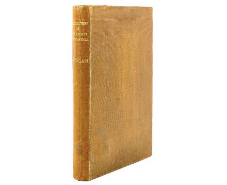
G. B. Worgan. 'General View of the Agriculture of the County of Cornwall'. 'Drawn Up and Published by Order of the Board of Agriculture and Internal Improvement,' first edition, 1 folding map, 10 single page plates, 5 folding plates 192 + II (publishers catalogue) + (ii) (catalogue of agriculture seeds) pages, B. McMillan, London, 1811.A scarce early survey of cornish agriculture. A very good copy, gilt lettering to spine, later hard boards.A small amount of staining to the modern cloth, a repair to the title page and the fold out map, spotting to the plates. A very good example of this work.

'England Displayed.' 1769 P. R. Russell (relating to England) Owen Price (relating to Wales). 'England Displayed. Being a New Complete and Accurate Survey and Description of the Kingdom of England and Principality of Wales,' this is one volume only and relates soley to Cornwall, map and four plates, frontispiece, complete, 22 pages, with the bookplate of W. G. S. Tonkin, original embossed full calf rebacked, Adlard and Browne, London, 1769.
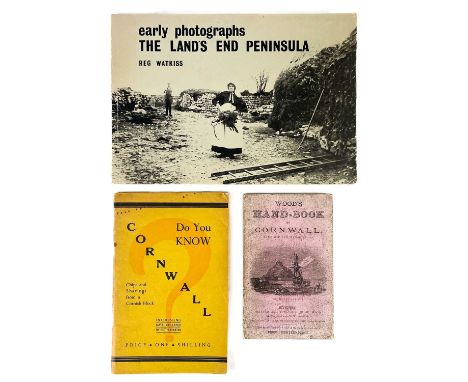
Three works. W. Wood. 'Wood’s Hand-Book to Cornwall with Map and Illustrations,' card wraps, fold out map, 142 pages plus advertisements, a good copy, Houlston and Sons, London, circa 1870s.Edith Martin. 'Do You Know Cornwall,' booklet, thin card wraps, various ditties from Cornwall, A. W. Jordan, Truro, 1936.Reg Watkiss. 'Early Photographs ‘’the lands end peninsula’’, first edition, first printing, a good copy, published by Whites of Alverton, Penzance, 1975. (3)3 booksreserve : £25
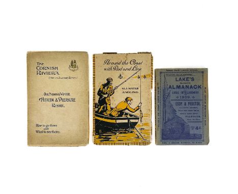
Three early 20th century guides. Felix J. C. Pole. 'Around the Coast With Rod and Line. Sea Water Angling Including Haunts and Hints for Anglers,' first edition, thin pictorial card wraps, spotting to front and rear leaves, good condition, published by The Great Western Railway Co, Paddington Station, London, 1925.James C. Inglis. 'The Cornish Riviera (new and enlarged edition),' thin card wraps, 152 pages, many adverts, map to the rear, good condition, issued by The Great Western Railway Co, Paddington Station, London, 1905.'Lakes Falmouth Almanack and Local Intellicencer for 1939,' thin pictorial card wraps, 112 pages including adverts, vg, Eddy & Proctor, Chemists, Falmouth, 1939.
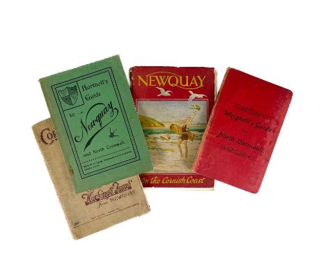
Four early guide books. 'Newquay. On the Cornish Coast,' 96 pages + advertisements, 37 pages of text, including copious photographs and a map of Newquay bound in, published by the Newquay Guide Committee, circa 1900.W. Weighell. 'Weighell’s Guide to North Cornwall,' folding map, illustrations, 127 pages + 7 pages of advertisements, small 8vo, 6th edition, Launceston, circa 1910.W.H.K.Wright (Borough Librarian, Plymouth). 'Hartnoll’s Hand-Book to Newquay and North Cornwall,' new and revised edition, 112 pages, circa 1930.James Ninnis. 'Cornwall. Guide to Hockings Tours ‘’The Silver Cars’’ from Newquay,' third edition, 96 pages including adverts, Hockings ran 12 regular tours from Newquay to various parts of Cornwall, this guide explains the routes, describes the villages and their history en route, 1927. (4)
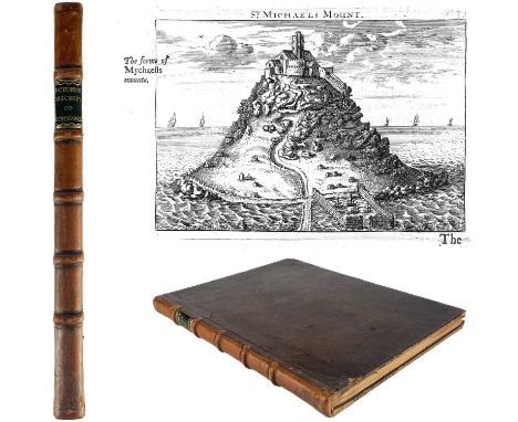
John Norden. 'Speculi Britanniae Pars,' 1728. 'A Topographical and Historical Description of Cornwall. With a Map of the County of Cornwall and Each Hundred; In Which Are Contained the Names and Seats of the Several Gentlemen then Inhabitants; As Also, thirteen Views of the most Remarkable Curiosities in that County. To which are Added the West Prospect of the Some Time Conventual Church of St Germans; And a Table of the Distances of the Towns from each other: with some Account of the Author,' first edition, engraved frontis, engraved dedication to the Earl of Oxford, 10 double-page maps and one plate, 13 engraved illustrations, original full calf tastfully rebacked, a very clean if not nearly fine copy of a scarce work, William Pearson for the editor and sold by Bateman, London, 1728.Norden was the first Englishman to complete a series of 'County Histories', however he became beset by financial difficulties. He succeeded in issuing the first part of ‘Speculum’ Middlesex in 1593 followed by ‘Hertfordshire’ in 1598, leaving in manuscript, five full surveys of other counties. Cornwall was not published until 1728 it was written in 1610 (and in 'Lowdnes' view, drew heavily on Carew’s 'Survey of Cornwall' 1602, though Norden probably visited the county as early as 1584).This copy is in a fine condition with a very small amount of spotting (as expected). There is a woodcut of Pendenis and Falmouth Haven including 10 double-page maps and one plate, 13 engraved illustrations.
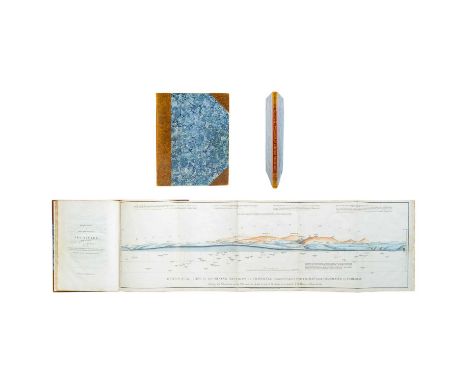
Richard Thomas. 'Report on a Survey of the Mining District of Cornwall,' 1819. 'From Chasewater to Camborne,' first edition, all tables etc complete, two (original) hand coloured folding illustrations and a facsimilie map to rear, as follows;'Geological View of the Mining District of Cornwall Corresponding with Map from Chasewater to Camborne, Shewing the Elevations of the Hills and the Depths to Which the Mines are Extended,' by R. Thomas, Falmouth.'Geological Sections in Illustration of the Map of the Mining District of Cornwall. Longitudinal Sections Shewing the Inclinations of the Cross Courses. Transverse Sections Shewing the Inclinations of the Lodes and Elvan Courses'.'A Geological Map of the Mining District of Cornwall, Shewing the Lodes, Cross Courses, Adits etc. not coloured, facsimile.Hansomely rebound, with gilt lettering to spine, a fine copy of a vary scarce item, published by John Cary, 181 The Strand, London, 1819.

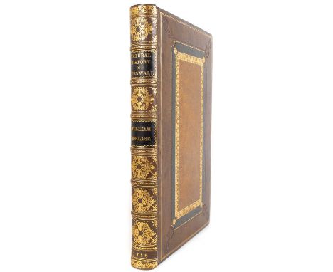
William Borlase. 'The Natural History of Cornwall,' 1758. 'The Air, Climate, Waters, Rivers, Lakes, Sea and Tides; Of the Stones, Semimetals, Metals, Tin and the Manner of Mining; The Constitution of the Stannaries; Iron, Copper, Silver, Lead and Gold Found in Cornwall. Vegetables, Rare Birds, Fishes, Shells, Reptiles and Quadrupeds; Of the Inhabitants, their Manners, Customs, Plays or Interludes, Exercises and Festivals; The Vornish Language, Trade, Tenures and Arts. Illustrated with a New Sheet Map of the County and Twenty-Eight Folio Copper-Plates from Original Drawings Taken on the Spot Together with a Subscribers list,' first edition, magnificently rebound, tooled embossed full leather, fold out map and all illustrations collated complete, printed for the author by W. Jackson, Oxford, 1758.This is an extremely fine copy of this famous work.
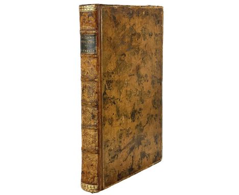
William Borlase. 'Antiquities, Historical and Monumental of the County of Cornwall,' 1769. 'Consisting of Several Essays on the First Inhabitants, Druid Superstition, Customs and Remains of the Most Remote Antiquity in Britain and the British Isles, Exemplified and Proved by Monuments Now Extant in Cornwall and the Scilly Islands, with a Vocabulary of the Cornu-British Language,' second edition revised with several additions by the author, to which is added a map of Cornwall and two new plates, a very good copy, in original binding, with all plates etc collated, no tears, W. Bowyer and J. Nichols for S. Baker and G. Leigh and others, London, 1769.
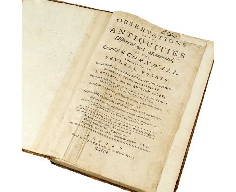
Williams Borlase (Rector of Ludgvan). Observations on the antiquities historical and monumental of the County of Cornwall, consisting of several essays on the first inhabitants, druid-superstition, customs, and remains of the most remote antiquity, first edition, 32 plates collated which includes the 'New Map of the County of Cornwall' from the 1769 edition, loosely inserted a signed note from John Borlase, dated October 19th 1770, this work was the first chronological account of the antiquities of the county, and the first book to describe, illustrate, and classify a significant number of them, it is divided into four sections: the early history of britain with special reference to cornwall; the rites and practices of the druids; the prehistoric monuments of cornwall; and the roman and later antiquities, an index included an english cornish vocabulary, a very good copy in probably original binding with raised bands and gilt lettering to spine, printed by W. Jackson, High Street, Oxford, 1754.

-
109198 item(s)/page