We found 109198 price guide item(s) matching your search

Refine your search

Year

Filter by Price Range
  • List
  • Grid
  • 109198 item(s)
    /page

Lot 689

[TOPOGRAPHY]. SOMERSET Collinson, Rev. John. The History and Antiquities of the County of Somerset, three volumes, by Cruttwell, Bath, 1791, full leather (re-backed, with incomplete spine labels), folding map frontispiece, a further thirty-nine engraved plate illustrations, subscribers list, quarto; together with Weaver, Rev. F.W., & Bates, Rev. E.H., editors. Index to Collinson's History of Somerset, Barnicott & Pearce, Taunton, 1898, brown cloth, quarto (latter ex library), (4).

Lot 691

[TOPOGRAPHY]. SOMERSET Phelps, Rev. W. The History and Antiquities of Somersetshire, Vol. I, Parts I & II, Nichols, London, 1836, & Vol. I, Parts III & IV, Nichols, London, 1836, bound as one, modern half leather retaining original stiff paper covers, twenty-nine plate illustrations (only), including maps, further text illustrations, large quarto; together with Phelps, Rev. W. The History and Antiquities of Somersetshire, Vol. II, by Nichols for the author, London, 1839, black half leather, the spine in compartments gilt, top edges gilt, frontispiece, map, seven plate illustrations, further text illustrations, large quarto, (2).

Lot 695

[TRAVEL] Bosman, William. A New and Accurate Description of the Coast of Guinea, Divided into Gold, the Slave, and the Ivory Coasts, containing a Geographical, Political, and Natural History of the Kingdoms and Countries: with a Particular Account of the Rise, Progress, and Present Condition of all the European Settlements upon that Coast; and the Just Measures for Improving the several Branches of the Guinea Trade, written originally in Dutch... And now faithfully done into English, second edition, for Knapton, Midwinter, Lintot, Strahan, Round & Bell, London, 1721, full leather, remains of engraved folding map frontispiece by Moll, seven further engraved plate illustrations (only; one torn, with 30% loss), octavo.

Lot 704

[TRAVEL] Barrow, John. A Collection of Authentic, Useful, and Entertaining Voyages and Discoveries, Digested in a Chronological Series, three volumes, for Knox, London, 1765, full speckled calf (re-backed), two folding map frontispieces, one further folding map, one folding chart and five further plate illustrations (one folding), small octavo.

Lot 706

[TRAVEL]. CENTRAL AMERICA Stephens, John L. Incidents of Travel in Central America, Chiapas, and Yucatan, first British edition, two volumes, Murray, London, 1841, modern quarter leather with marbled boards, folding map, seventy-eight plate and text illustrations, including frontispieces (32 + 46; one more than called for), octavo (foxed).

Lot 707

[TRAVEL]. CHILE Molina, Abbe Don J. Ignatius. The Geographical, Natural, and Civil History of Chili, translated [into English], two volumes in one, for Longman et al., London, 1809, modern half calf, folding map frontispiece, publisher's lists, octavo.

Lot 708

[TRAVEL]. ASIA Murray, Hugh. Historical Account of Discoveries and Travels in Asia, three volumes, for Constable et al., Edinburgh / London, 1820, modern tan buckram with brown leather title labels to spine, folding map frontispiece, three further folding maps, octavo (ex Foreign Office library).

Lot 709

[TRAVEL]. INDIA Penny, F.E. Southern India, first edition, Black, London, 1914 (20s. Series), decorative orange cloth (slightly stained patch to spine), fifty paper-protected colour plate illustrations by Lady Lawley (including frontispiece, as called for), folding sketch map (at end), two pages of publisher's advertisements, two-page publisher's list, quarto (lower hinge weak).

Lot 710

[TRAVEL]. Fox, Frank. Australia, first edition, Black, London, 1910, decorative blue cloth gilt, top edges gilt, seventy-five paper-protected colour plate illustrations by Percy Spence (including frontispiece, as called for), folding sketch map (at end), four-page publisher's list, quarto; together with Koebel, W.H. South America, first edition, Black, London, no date [1912], decorative green-grey cloth, top edges gilt, seventy-five paper-protected colour plate illustrations by A.S. Forrest (including frontispiece, as called for), folding sketch map (at end), two pages of publisher's advertisements, quarto; and three other works from Black's 20s. series, (5).

Lot 736

[MISCELLANEOUS] Wigram, Edgar. Northern Spain, first edition, Black, London, 1906, decorative dark orange cloth, top edges gilt, seventy-five paper-protected colour plate illustrations by the author, folding sketch map (at end), four-page publisher's list, quarto (hinges weak; one plate detached); Holland, Clive. Wessex, first edition, Black, London, 1906, decorative dark green cloth gilt, top edges gilt, seventy-five paper-protected colour plate illustrations by Walter Tyndale, folding sketch map (at end), quarto (spine with damp stain towards head); and three other titles from Black's 20s series, (5).

Lot 737

[MISCELLANEOUS] Henderson, John. The West Indies, first edition, Black, London, 1905, decorative pale blue cloth (spine evenly browned), top edges gilt, seventy-four paper-protected colour plate illustrations by A.S. Forrest, four-page publisher's list, quarto (upper hinge repaired); Holland, Clive. Warwickshire, first edition, Black, London, 1906, decorative blue cloth, top edges gilt, seventy-five paper-protected colour plate illustrations by Frederick Whitehead, folding sketch map (at end), eight-page publisher's list, quarto; and six other Black titles, (8).

Lot 738

[MAP]. INDIA Thacker's Reduced Survey [folding] Map of India, by J.G. Bartholomew, fifth edition, Thacker, Calcutta & London, 1914, one inch to seventy English miles, colour printed, with plans of Bombay, Calcutta and Madras, approximately 101cm x 92cm, blue cloth covers (index detached; some place-names underlined).

Lot 740

[MAP]. YORKSHIRE Speed, John (1552-1629), 'The West Ridinge of Yorkeshyre', engraved map, sold by Thomas Bassett and Richard Chiswell, hand-coloured, English text verso, 40cm x 52.5cm, framed and glazed in a double-sided frame (peripheral staining and tears; upper right corner detached).

Lot 741

[MAP]. SUFFOLK Speed, John (1552-1629), 'Suffolke', engraved map, sold by George Hu[m]ble, hand-coloured, English text verso, 38.5cm x 50cm, framed and glazed in a double-sided frame.

Lot 742

[MAP]. MEXICO Sanson, Nicolas (1600-1667), 'Audience de Mexico', engraved map, hand-coloured (colouring now faded), 17.25cm x 27.5cm, mounted but unframed.

Lot 743

[MAP]. VENEZUELA Blaeu, Willem Janszoon (1571-1667), 'Venezuela cum parte Australi Novae Andalusiae', engraved map, hand-coloured, 37.5cm x 49cm, framed and glazed.

Lot 744

[MAP]. COLUMBIA Blaeu, Willem Janszoon (1571-1667), 'Terra Firma et Novum Regnum Granatense et Popayan', engraved map, hand-coloured, 37.5cm x 49cm, framed and glazed.

Lot 749

[ATLAS] Atlas of the Chinese Empire, containing separate maps of the Eighteen Provinces of China Proper..., and of the Four Great Dependencies, by Edward Stanford for The China Inland Mission, London / Shanghai, no date [circa 1908], maroon cloth gilt, twenty-three coloured maps (including Index Map; as called for), folio.

Lot 171

Bartholomew Map of Yorkshire, 65 x 75 cm and a Scarborough Railway reproduction poster (2).

Lot 75

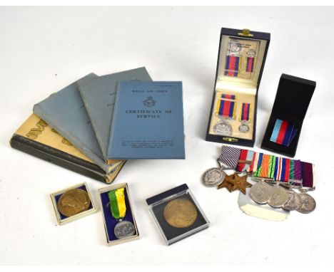
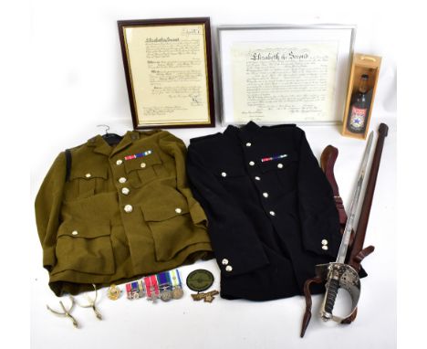
The WWII and Malaya Distinguished Flying Medal group and extensive archive of 1522919 Flight Sergeant and Master Navigator Eric Parker, Royal Air Force.  Flight Sergeant Parker performed navigational duties in Bomber Command, Far East Air Force and Transport Command on Lancaster, Lincoln, B29, Canberra, York, Dakota and Beverley aircraft with 'Exemplary' conduct detailed in three log books with entries from 1943 to 1963 and numerous Confidential RAF Flight Plans for the Western Theatre of WWII comprising Chemnitz, Dortmund (x2), Pforzheim, Duisberg, Mannheim, Cologne, Essen, Gelsenkirchen, Misburg, Nuremburg, Hamburg, Nordhausen, Kiel Bay (x2), Plauen, Heligoland, Bremen, Le Hague (with map detailing route) and Valkenburg with further untitled; Parker completed over 30 bombing operations over Germany and in 1945 took part in Operation Manna/Chowhound dropping food supplies to the starving people of Holland.The medal group comprises in full the Distinguished Flying Medal, WWII War and Defence Medals, France and Germany and 1939-1945 Stars (latter with 'Bomber Command' clasp), and Elizabeth II General Service Medal with 'Malaya' clasp and Elizabeth II RAF Long Service and Good Conduct Medal (DFM rank F/Sgt, GSM rank F/Sgt, RAF LSGC M.Nav), all on original ribbons ; also present is the Malaysian Pingat Jasa Medal and Miniature and three 1985 Dutch medals commemorating Operation Manna/Chowhound.The archive includes the aforementioned Log Books and Flight Plans,  RAF Certificate of Service, DFM Warrant certificate dated 1958, DFM letter of issue from Buckingham Palace with printed King George VI signature, navigational tools (two in pouch with military issue 'broad arrow' stamp), numerous photographs featuring Parker individually, with crew mates and wider RAF personnel, newspaper articles relating to his service, further RAF certificates and Royal Visit booklets, two dress ties and a CD recording of Parker's interview with the International Bomber Command Centre Digital Archives. Additional InformationThe exact naming on the DFM is 1522919 F/SGT. E. PARKER RAF; this is the original medal which was kept by F. Sgt Parker throughout his life and comes to market directly from his estate.

Lot 75A

The rare and important military honour medal group and related items of Major Antony Harrison Douglas MBE BSc Eng Psc(n)+ RE, a Sapper in the Royal Engineers who served in the Falklands with 11 Field Squadron. Comprising South Atlantic Medal with Rosette, General Service Medal with Northern Ireland clasp, MBE, miniature trio, Royal Engineers cap badge, Harrier Support Force cloth badge & another, pair of spurs, map of the Falklands, MBE citation signed by HRH Queen Elizabeth II & Prince Philip, Officer citation, Royal Engineers dress sword with shagreen grip & engraved blade inscribed "A.H. Douglas 9-3-73", khaki uniform and dress jacket, newspaper articles, photograph, a bottle of "Task Force Special Ale" issued by the Sunday Mirror, a Falkland Islands 50 pence bank note and a folder of letters congratulating Major Douglas on receiving his MBE.Major Douglas joined the army in the 1970's and during an extremely varied career served in Northern Ireland for four and a half months during the height of the Troubles. In one of the highlights of this tour his squadron was given the task of demolishing the Creggan Wall which separated Catholic and Protestant estates in Londonderry.  He also served in Germany, Canada and Belize where he was seconded to the Governor's Office to help staff the Independence celebrations in 1981.After the Argentinians invaded the Falkland Islands on 2nd April 1982, Major Douglas's 11 Squadron (he was second-in-command at the time) was part of the Task Force deployed to regain control of the territory, of which, much like the rest of the population of the UK, he had never heard before. First they spent a few weeks loading up equipment and supplies, as their primary task was to provide a forward operating base (FOB) for the Harrier Force providing critical air cover during the operation. After supplies were loaded, the squadron departed in early May and met up with the rest of the Task Force on Ascension Island in the mid-Atlantic where an RAF air base had been established. 11 Squadron then sailed to the Falklands on the RFA Sir Bedivere and went ashore on the 23rd May as part of the initial landings to Port San Carlos. Unfortunately, the ship carrying the supplies that the squadron had spent several weeks preparing was torpedoed by the Argentinian Air Force so they improvised with what remaining supplies were available.The Argentinian forces surrendered on 14th June, 74 days after they first invaded. 11 Squadron was amongst the first troops sent into Stanley, the capital of the territory, to clear the landmines and make it safe. The town normally had a population of around 900. However, in the aftermath of the conflict there were some 3,000 British troops and 10,000 Argentinian troops, overwhelming the infrastructure. Major Douglas and the rest of 11 Squadron eventually returned to Britain in mid-September after successfully ensuring the town of Stanley was safe and secure for its inhabitants.Major Douglas was awarded his MBE in 1985 whilst back in the Falklands with 11 Squadron. This time he was Commanding Officer, tasked with keeping the airfield operational as a bridgehead to deter any further invasion.  He also worked as a Staff Officer at the Ministry of Defence, doing ground work for various senior officers. In August 1990, he was asked to prepare a brief detailing the operational effectiveness of the army, which he prepared overnight. It was shown to Margaret Thatcher the next day, who used it in making the decision to commit a brigade to the Persian Gulf to retake Kuwait after the Iraqi invasion.

Lot 1145

A collection of books on maps/cartography related volumes including Map Cover Art by John Paddy Browne, Terra Incognita, Magnificient Maps by Peter Barber and Tom Harper etc.

Lot 1239

A box containing miscellaneous items including map of Suffolk, treen lidded box, nut crackers and plated spoon etc.

Lot 1286

Five 18th Century and later maps including Kitchin hand coloured map of Essex and Morden example

Lot 1310

A hand coloured map of Norfolk after Saxton, framed and glazed

Lot 1066

Five volumes on town, city and road maps: Bartholomew's Touring Atlas and Gazetteer of the British Isles 1900 (modern hardback), Mapping the Roads by Mike Parker, The South-West Highway Atlas for 1675, Tamar Books, Ordnance Survey Map Makers to Britain since 1971 by Owen and Pilbeam, and Town and City Maps of the British Isles 1800-1855 by Ahley Baynton-Williams

Lot 1068

Two British Library volumes on map history: "Mapping Time and Space, How Medieval Mapmakers Viewed their World" by Evelyn Edson and "English Maps A History" by Catherine Delano-Smith and Roger J.P.Kain, hard covers

Lot 1069

Seven map/cartography books including The County Maps of Old England, Sense of Place by Kim Leslie and The Counties of Britain

Lot 1070

Seven map/cartography related volumes including Mapping The World by Nathaniel Harris and The Men who Mapped The World by Beau Riffenburgh

Lot 350

ROBERT PLOT - 'THE NATURAL HISTORY OF STAFFORDSHIRE' 1686, rebound, lacks map, some plates damaged and repaired

Lot 358

A SURVEY AND PLAN OF THE ROAD FROM THE CITY OF LINCOLN' BY S. BEE, folded sectional linen backed 18th Century map with original hand colouringCondition Report: Card coming away from linen in a number of places, one section completely detached

Lot 359

A COLLECTION OF FOLDING SECTIONAL MAPS to include Walker's Warwickshire c.1846, Blackwood's Linlithgowshire, Letts Map of Essex, Letts Map of Oxford, Reynolds's New Map of London A/F, Philips' Cyclists' map of the Country Round London, 'The Cyclist Pocket Touring Maps of Britain in slipcase, together with Taunt's Map & Guide to The Thames, New Pocket Edition etc.

Lot 361

THOMAS JEFFREYS - A NEW MAP OF STAFFORDSHIRE 1747, printed for Samuel Parsons, framed and glazed but poor condition, framed size 74 x 75.5 cmCondition Report: Linen backed but surface losses showing backing , very creased, staining

Lot 1034

J.B Clough, extensive river landscape, signed and dated 19(96) oil on board together with a British school Lake landscape, a print after Marcel Dyf, a map of Windemere and a print after Pieter de Hooch

Lot 102

An orange Anglepoise lamp - museum purposes only, an Eastern rug, two horn beakers, an alabaster Buddha and beaker, two papier mache snuff boxes, German penknife, brass box compass and pocket compass, framed map, and various motoring books, etc

Lot 253

VINTAGE LEATHER MAP CASE of satchel design, with a number of maps contained within, sorted by area dividers, and another leatherbound map case

Lot 188

An early 19th century framed tapestry map, A Map of England and Wales by Hannah Cook 1804, 18.5ins x 16ins, together with a framed tapestry sampler by Mary Hobbs aged 11 October 29, 12ins x 9.5ins

Lot 233

A Guide to the Lakes in Cumberland, Westmorland and Lancashire, by Thomas West 1821, eleventh edition, includes fold-out map, re-bound

Lot 522

JOHANNES BLAEU (Dutch 1596-1673) Eborasensis, hand coloured and engraved map, double page, 39.5cm x 51.5cm. See illustration

Lot 523

JOHN SPEED (1552-1629) THE DESCRIPTION OF EUROPE, hand coloured and engraved map 1626, bordered by vignettes of the chief cities and portraits representing the various nationalities, double page, glazed front and back, 39.5cm x 51cm. See illustration

Lot 524

JOHN SPEEDE (1552-1629) The Bishopric and Citie of Durham, 1611, hand coloured engraved map, double page, 39cm x 51cm

Lot 525

JOHN SPEEDE (1552-1629) The Countie Westmorland and Kendal The Cheif Towne Described, 1611-1631, hand coloured engraved map, double page, 39cm x 52cm

Lot 526

JOHN SPEEDE (c.1552-1629) Darbieshire Described 1610, hand coloured engraved map, double page, 39cm x 51.5cm

Lot 527

JOHN SPEEDE (1552-1629) The County Palatine of Chester 17th century hand coloured engraved map, double page, 39cm x 51cm

Lot 528

JOHN SPEEDE (1552-1629) The Countie of Nottingham, hand coloured engraved map, double page, 39cm x 51.5cm, unframed

Lot 529

JOHN SPEEDE (1552-1629) The Kingdome of Great Britain and Ireland, hand coloured engraved map, double page, 39cm x 52.5cm; together with The Kingdome of Ireland 1610, engraved, double page map (losses) 37.5cm x 50.5cm, unframed (2)

Lot 530

CAMDENS BRITANNIA 1607 - Christopherus Saxton map of Northumbriae, hand coloured engraved plate, 30cm x 31cm, framed

Lot 323

Horace an early Chad Valley teddy bear 1915 1920, with golden mohair, clear and black oily glass eyes with brown painted backs, pronounced clipped muzzle, black stitched nose, mouth and claws, swivel head, jointed limbs with cloth pads and card lined feet, solidly cork stuffed, rare pink map of England button and knitted green jumper ”18in. (46cm.) high (balding to upper back and front, general wear and thinning, three pads replaced and some black stitching replaced)

Lot 2

A Bevan Funnel extending dining table and eight chairs together with a wall unit, side board and two map top coffee tables

Lot 387

The Fab FourA photographic image of Lee Byrne, Shane Williams, Mike Phillips and James HookSigned in silver penTogether with a map of London

Lot 184

A 19th century horn and tortoiseshell mounted snuff box, a monocle, a German cigarette tin, three 19 century brass hinged buckles, a brass "devil drink" bottle stopper, a brass thread gauge and a map gauge

Lot 313

Mixed pictures to include a George Spence oil painting, a map of Buckinghamshire and one of Berkshire by C & J Greenwood, two Hero Nim prints and others

Lot 328

Framed Map of the East Riding of Yorkshire by T. Kitchen circa 1770

Lot 332

Double Sided Strip Map of Marlborough and Middlesex

Lot 333

Map of Kent Published by W.H. Toms 1742

Lot 394

Royal Air Force Bomber's and Gunner's Flying Log Book, plus Documentation, Photographs Silk Map and Aerial Bombing Photographs

Lot 1980

Elizabeth II hallmarked silver map of Great Britain with boundary lines and coats of arms of the historic counties, London 1978, a limited edition issued by the Council for Protection of Rural England, 68.5 x 50cm, weight of map on backing but out of frame 850g all in

Lot 3653

George III oval embroidery sampler A Map of England and Wales by Diana Sanders 1787, 63 x 53cm

Lot 11

Falklands are British - A news special on the Falklands war and map of the Falklands. A nice original lot.

Loading...Loading...
  • 109198 item(s)
    /page

Recently Viewed Lots