

Original vintage travel advertising poster: Map of South Island New Zealand with the compliments of Lew Andrews Signs. Colourful design featuring a yellow map of the South Island of New Zealand with the roads and lakes marked, surrounded by scenic illustrations of the landscape, including rivers, waterfalls, forests and mountains as well as animals, birds, flowers and ferns and people enjoying outdoor activities such as hunting, fishing, glacier/mountain walking and skiing with a decorative Maori border design on the sides and the text above. Published by A. D. Baldwin, Universal Business Directories Ltd., Auckland. Land & Survey Licence no 1958/3. Very good condition, restored folds and repaired tears. Backed on linen. Country:New Zealand. Year:1958. Designer:Unknown. Size (cm):101x77
We found 109198 price guide item(s) matching your search
There are 109198 lots that match your search criteria. Subscribe now to get instant access to the full price guide service.
Click here to subscribe- List
- Grid
-
109198 item(s)/page

Original vintage travel advertising poster: Map of North Island, New Zealand with the compliments of Lew Andrews & Co., Sign Writing Service. Colourful design featuring a yellow map of the South Island of New Zealand with the roads and lakes marked, surrounded by scenic illustrations depicting various outdoor activities including horse racing, water skiing, rugby, golf, sailing, car racing, climbing, scuba diving, skiing and fishing with views of the landscape, including rivers, forests and mountains with a decorative Maori border design on the sides and the text above. Published by A. D. Baldwin, Universal Business Directories Ltd., Auckland. Land & Survey Licence no 1958/3. Good condition, folded as issued, creases, minor tears in margins. Country:New Zealand. Year:1958. Designer:Unknown. Size (cm):102x76

Original vintage travel advertising poster for the Soviet state travel agency Intourist Soviet Liners / Liners Sovietique from Leningrad to London and Le Havre. Great design shows a boat and seagulls above a yellow map on a blue background with the shipping routes to London and Le Havre from Copenhagen Helsinki Gdynia Stockholm and Leningrad. Good condition, tears in margin, light staining Country: Russia, year: 1960s, Size (cm)99x60

Original vintage travel poster Who Says Ski Says Swiss / Qui Dit Ski Dit Suisse promoting Switzerland featuring a great design by Pierre Monnerat (b 1917) of a skier on top of a snowy mountain holding a piste map. Good condition, light staining, creasing, pinholes, small tears in margin, small paper loss in margin. Country: Switzerland Designer: Pierre Monnerat Year:1960s Size: 102x64

Original vintage travel advertising poster for Florida – Fly Northwest to Florida – Northwest Orient Airlines. Great retro design featuring a photograph of people enjoying the sunshine on a sandy beach with a young couple talking below palm trees in front of the sea as a lady wearing a red bikini runs by and another couple in the foreground lies relaxing on a beach towel with the map of the United States on it marking the flight route, the text above and below in stylised white letters. Northwest Airlines was founded as Northwest Airways in 1926 (initially as a mail route before offering passenger services from 1927), changing its name to Northwest Airlines in 1933 and branding its transpacific flights under Northwest Orient Airlines; in 2010 the company merged with Delta Air Lines. Printed in USA. Very good condition, faint creases in margins. Country:USA. Year:1960s. Designer:Unknown. Size (cm):101.5x63.5

Original vintage travel advertising poster depicting a tourist map of London with a blue border made up from London Transport Logos - The map lists stations connecting London underground stations and British Rail stations. Places of interests are also indexed and displayed on the map grid such as Hyde Park The National History Museum and Somerset House. Printed by Cook Hammond and Kell LTD Mitchem and Westminster. Good Condition, folds, creasing, light staining, small tears in bottom right corner. Country: UK Year: 1970, Size: 100x124.5

Original vintage travel advertising poster depicting a tourist map of London with a blue border made up from London Transport Logos - The map lists stations connecting London underground stations and British Rail stations. Places of interests are also indexed and displayed on the map grid such as Hyde Park The National History Museum and Somerset House. Printed by Cook Hammond and Kell LTD Mitchem and Westminster. Good Condition, folds, creasing, light staining. Country: UK Year: Size: 100x124.5

Original vintage travel advertising poster for Centovalli Glorious Lake Maggiore (Switzerland) for your Next Holiday Locarno - Domodossola - Simplon The fastest Railway connection between Ticino and Geneva Bern. Fantastic colourful illustration depicting the Centovalli valley in the Swiss Alps with Lake Maggiorre in the foreground, showing a view over the mountains from the sky with the railway lines and names of the different stops (including Bern, Geneva, Interlaken, Zermatt, Montreux, Lausanne, Locarno and Ascona) marked along the route map with the text above the snow topped mountains on the horizon in stylised red letters and information below printed on an added stripe of paper in English. Artwork by Berann (Heinrich Casar Berann; 1915-1999). Printed in Switzerland by Brugger AG, Meiringen. Good condition, small tears in margins, creases and folds. Switzerland,1970s. Designer: Berann. Size (cm):102x64

Original vintage poster map of the main ski trails in the Laurentians mountain range in Quebec Canada featuring colourful advertisements and illustrations on the borders including the Laurentians crown and snow covered tree images on the four corners, a notice to ski carefully by Frontenec Breweries Ltd, hotels, a Royal Typewriter ad, Canadian Pacific Railway and Canadian National Railways, long distance telephone rates, clothing, ski equipment, food and drink ads for Oxo and Salada tea etc., with the map legend and scale below the ski routes, alpine stations, lakes and rivers, hotels, roads and mountains marked in various colours. Good condition, restored folds and minor loss on margins, backed on linen. Country:Canada. Year:1940s. Designer:George Hemsley. Size (cm):70x50.5

Original vintage ski poster promoting skiing holidays in the Tatra Mountains organised by the Turista travel agency. Great mid-century image of a lady reading a ski slope map with chalets, skiers and snowy mountains in the background. Very good condition, dust on the right and bottom margins, backed on linen. Country:Czechoslovakia. Year:1954. Designer:Initialed J . Size (cm):85x58.5


An engraved county map of Buckinghamshire, and one other of Northamptonshire; Robert Morden - late 17th century engraved county map of Huntingdonshire, 37x42cm; and Cruchley's Road & Railway Map of the county of Hertford (4)CONDITION: Buckinghamshire engraved by Pigot & Son, Manchester. Northampton not named.


THOMAS KITCHEN - 'An accurate map of Cardiganshire' together with 'An accurate map of Pembrokeshire', hand coloured engraving, taken from one plate printed on a joined sheet, from The Large English Atlas, circa 1762, framed, 70cm x 53cm, also two maps by Emanuel Bowen 'Shropshire divided into it's Hundreds' and 'Staffordshire divided into it's Hundreds' (3)


A rare copper plate "Pocket Map" of the cities of London and Westminster and the Suburbs Thereof Being a New and Exact Plan with the Addition of the New Buildings, Churches etc. to the Present Year 1731, also with lists of Fixing of Rates and Fares of Watermen by Ancient Act of Parliament from 1671, approx 25 different routes and destinations are priced from 3d to 2s (3 pence to 2 shillings) and much more information in gilded and oak frame 18" x 12" museum quality G+

![STAFFORD, LADY [ELIZABETH LEVISON GOWER], COUNTESS OF SUTHERLANDVIEWS IN ORKNEY AND ON THE NORTH-EASTERN COAST OF SCOTLAND [L](https://cdn.globalauctionplatform.com/80c1eebc-57e7-4158-95af-a9af00acf388/dd2016af-e877-4773-a8c1-a9ce00bb786d/468x382.jpg)
STAFFORD, LADY [ELIZABETH LEVISON GOWER], COUNTESS OF SUTHERLANDVIEWS IN ORKNEY AND ON THE NORTH-EASTERN COAST OF SCOTLAND [London:] 1807. Folio, 28 plates, foxing to half-title and title page, modern brown half morocco, bookplates and laid-in compliments slip from the Marchioness of Stafford to The Right Honourable Speaker; Thomas, F.W.L. Account of some of the Celtic Antiquities of Orkney. London: J.B. Nichols and Son, 1851. 4to, John Davie Manson Robertson bookplate, ownership signature to title-page, occasional marking in pencil, folding map, 5 uncoloured plates, new endpapers, modern quarter morocco backed cloth (2)

19 18-19TH CENTURY MAPS INCLUDINGRAMSAY, ANDREW C. Geological Map of the British Isles. Edward Stanford, 1878, hand-coloured folding map, slipcase; Rocque, John The Traveller's Companion of the Post Roads of England and Wales. Robt. Sayer, 1786, engraved map, divided in sections backed on linen, hand-coloured in outline, slipcase; Seaton, Robert Seaton's Map of Palestine or the Holy Land. London: for Robt. Seaton, [c.1820 ?], hand-coloured engraved map, 84 x 98cm., folding into red half roan, worn; Index to the Ordnance Survey of the Counties of Fife and Kinross. Edinburgh, 1871, map in sections backed on linen, folding into green cloth; Vuillemin, A. Plan pittoresque de la ville de Paris. Paris, 1840, folding map, divided in sections and backed on linen, engraved vignettes; Geikie, Sir Archibald Map showing the Surface Geology of Ireland. [c.1892], coloured map, folding into blue cloth gilt; Geological Map of Scotland. 1892, folding into blue cloth gilt; Bartholomew, J.G. The Imperial Map of England & Wales. Fullarton & Co., [n.d.], folding map on 19 sheets, divided and backed on linen, no slipcase; Bartholomew, J.G. Bartholomew's Revised "half-Inch" contourned Maps. Scotland. 29 maps, folding into blue covers, in worn & repaired box; and 9 others (listed in Condition Report)

EUROPEAN TRAVEL, GIBRALTAR, MALTA, SICILY, FRANCE, 4 VOLUMES, COMPRISINGDRINKWATER, JOHN A History of the late Siege of Gibraltar. London: J. Johnson &c., 1786. Second edition, 4to, 4 folding plans, 6 folding plates, tear to some plans neatly repaired, list of subscribers, contemporary tree calf, rubbed, upper joint split; Brydone, P. A Tour through Sicily and Malta, in a Series of Letters to William Beckford. London: W. Strahan, 1786. 2 volumes, 8vo, folding map, contemporary calf, neatly rebacked retaining original spines; Le Francois, A.B. Mysteries of the Old Castles of France. London: W. Strange, [1848], 8vo, bookplate of Eric S. Quayle, original blindstamped cloth, rubbed (4)


8 VOLUMES RELATING TO ROMANS IN BRITAIN, & TRAVEL, COMPRISINGCURLE, JAMES. A ROMAN FRONTIER POST AND ITS PEOPLE Glasgow, 1911. 2 volumes, 4to, Special Edition on hand made paper, number 30 of only 60 copies, original quarter morocco, t.e.g., Steuart, Robert Caledonia Romana, a descriptive account of the Roman Antiquities of Scotland. Edinburgh, 1852. Large 8vo, 5 maps and 16 plates, original cloth, rubbed; Christison, D. Early Fortifications in Scotland. 1898. 8vo, plates, maps, original buckram; Finden The Ports, Harbours, Watering Places and Picturesque Scenery of Great Britain. Virtue, [c.1870], 2 volumes in one, 4to, engraved titles and plates, original pictorial green cloth gilt, g.e.; Taylor, J. Taylor & Skinner's Survey of the Roads of Scotland. Edinburgh: T. Brown, [c.1805, final plate so watermarked], original boards, lacks map of Scotland (as usual), rebacked; Johnstone, J. Picture of Roslyn Chapel & Castle. Edinburgh, 1825. 12mo, engraved title & 7 plates, contemporary calf; Cary, John Cary's New Itinerary, or an Accurate Delineation of the Great Roads. London, 1815. Sixth edition, 8vo, 7 maps, modern morocco, one map laid down on linen (8)

KEPPEL, GEORGEPERSONAL NARRATIVE OF A JOURNEY FROM INDIA TO ENGLAND London: Henry Colburn, 1827. 2 volumes, 8vo, 2 hand-coloured frontispieces, folding map, 1 hand-coloured plate (a little trimmed), contemporary half calf, bookplates, without publisher's catalogue, a little internal soiling (2)
POZZUOLIMAZZELLA, SCIPIONE Sito, et antichità della città di Pozzuolo, e del suo amenissimo distretto. Con la descrittione di tutti i luoghi notabili, e degni di memoria. Con le figure de gli edificii, e con gli epitafi che vi sono. Naples: nella stamperia di Tarquinio Longo, ad instanza di Giorgio Varisco, 1606. 2 parts in 1 vol., 8vo., with 19 woodcut illustrations in the text, lacking the map of Pozzuoli, with neat earlier repair to the lower margin of the title page. Note: The second part is 'Opusculum de balneis' [bound with] Apparato delle statue. Naples: appresso Tarquinio Longo, 1606, contemporary vellum; Sarnelli, Pompeo Guida de'forestieri, curiosi di vedere le cose piu notabilli di Pozzoli … tradotta in Francese … da Antonio Bulifon. 12mo., engraved portrait frontispiece of Antonio Bulifon, engraved title page, with an engraved folding map, an engraved folding Arabic inscription, an engraved folding plan of the baths of Trotoli , and 27 other engraved plates, contemporary vellum, wear at head and tail, book plates of John and Michel Bury; Parrino, Domenico Antonio Nuova guida de' forastieri per l'antichita curiosissime di Pozzuoli. Naples: presso il Parrino, 1727. 12mo., engraved frontispiece, 30 engraved plates (some folding), contemporary vellum, with the book plates of John and Michael Bury; D'Ancora, Gaetano Guide du voyageur pour les antiquités et curiosités naturelles de Pouzol … traduit … par M. A. Barles de Manville. Naples: Zambraia Imprimeur, 1792. 8vo., with an engraved portrait frontispiece of the Empress Maria Theresa of Austria, an engraved title page, 50 engraved plates (including folding) and an engraved final plate, original paper wrappers, uncut, edges a little dusty, book plates of John and Michael Bury (4)

SCOTTISH HISTORY, 36 VOLUMES, INCLUDINGCHAMBERS, ROBERT Domestic Annals of Scotland. 1874. 3 volumes, 8vo, contemporary half calf gilt; another set, Second edition, 3 volumes, 8vo, contemporary tree calf gilt; Burton, William A Commentary on Antoninus his Itinerary. 1658. 4to, double-page map, quarter morocco; The Complaynt of Scotland. Written in 1548. Edinburgh, 1801. 8vo, maroon half morocco gilt; Analecta Scotica. Edinburgh, 1834, 2 volumes, 8vo, limited to 100 copies, contemporary brown quarter morocco; Brown, P.H. Tours in Scotland 1677 & 1681. 1892; Early Travellers in Scotland, 1891; Scotland before 1700. 1893, original cloth; Lowther, C. Our Journall into Scotland. 1894, original cloth; Society of Antiquaries of Scotland. Proceedings. Edinburgh, 1855-78. 12 volumes, 8vo, contemporary half morocco gilt, g.e.; The Spottiswoode Miscellany. 1844, 2 volumes, 8vo, original cloth, rubbed; Maclean, J.P. History of the Island of Mull. Greenville, 1923, 2 volumes, 8vo, brown half morocco gilt; Wilson, D. Memorials of Edinburgh in the Olden Time. 1891. 2 volumes, 8vo, original cloth; Society of Antiquaries of Scotland. Archaeologia Scotica. Vol. 4 parts 1-3 & vol. 5 parts 1-3 only, engraved plates, original wrappers, faded; sold not subject to return (36 volumes & 3 boxes of maps)
![AULDJO, JOHNSKETCHES OF VESUVIUS, WITH SHORT ACCOUNTS OF ITS PRINCIPAL ERRUPTIONS London: Longman, Rees [&c.], 1833. Firs](https://cdn.globalauctionplatform.com/80c1eebc-57e7-4158-95af-a9af00acf388/c5d5bda9-06eb-4b21-bc40-a9ce00bbab49/468x382.jpg)
AULDJO, JOHNSKETCHES OF VESUVIUS, WITH SHORT ACCOUNTS OF ITS PRINCIPAL ERRUPTIONS London: Longman, Rees [&c.], 1833. First edition, 8vo, [viii], 94; 16 lithographed plates, 1 hand-coloured folding map, several other plates from another work tipped in at beginning and end, original red cloth, paper label to spine, early inscription of Cosbyn Barrow 1851 and bookplate of Henry Newman, head and base of spine slightly rubbed

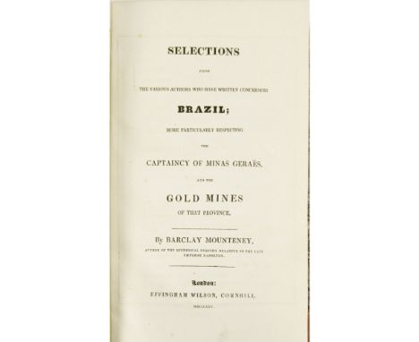
MOUNTENEY, BARCLAYSELECTIONS FROM THE VARIOUS AUTHORS WHO HAVE WRITTEN CONCERNING BRAZIL: more particularly respecting the Captaincy of Minas Geraes and the gold mines of that province. London: Effingham Wilson, 1825. First edition, 8vo., engraved map with hand colouring in outline as frontispiece, contemporary half calf, marbled boards, corners a little rubbed, with the book plate of John Bury on the rear pastedown; [Conder, Josiah] The modern traveller: a popular description, geographical, historical, and topographical of the various countries of the globe: Brazil and Buenos Ayres. London: James Duncan, 1825. 2 vols., 12mo., folding engraved map as frontispiece to vol. 1, and 7 engraved plates, contemporary half calf, marbled boards, book plates of John Bury and inscription on the front pastedowns (3)Note: Sabin 51191. The first 6 chapters are on the history of Brazil, the voyage to Brazil and ports, geography, natural history and medical diseases there. The rest of the book is on the geology, mineralogy, and mining in Minas Geraes. A list of works consulted is provided at the end and include the Encyclopaedia Britannica, Humboldt, Southey, John Mawe, Caldleugh, Koster, etc.
![[INDIA, DECCAN & BURMA, 2 VOLUMES] - TAYLOR, CAPT. MEADOWSDESCRIPTIONS OF CAIRNS, CROMLECHS, KISTVAENS, and other Celtic,](https://cdn.globalauctionplatform.com/80c1eebc-57e7-4158-95af-a9af00acf388/e05d70f9-3056-46b8-9f54-a9ce00bb9150/468x382.jpg)
[INDIA, DECCAN & BURMA, 2 VOLUMES] - TAYLOR, CAPT. MEADOWSDESCRIPTIONS OF CAIRNS, CROMLECHS, KISTVAENS, and other Celtic, Druidical, or Scythian Monuments in the Dekhan. Dublin: MH. Gill, 1865. Presentation copy "with the author's compliments to Professor Simpson", illustrations, 2 plates, contemporary blue half calf, binding slightly rubbed & slightly soiled; Symes, Michael Constable's Miscellany... An Account of an Embassy to the Kingdom of Ava, in the year 1795. Edinburgh: Constable, 1827. 2 volumes in 1, 12mo, folding map, additional engraved titles, contemporary half calf, rubbed, some spotting (2)


GORDON, PATRICKGEOGRAPHY ANATOMIZ'D, OR THE GEOGRAPHICAL GRAMMAR: being a short and exact analysis of the whole body of modern geography. London: for J. Nicholson [et al.], 1711. 6th edition, 8vo., title page in red and black, with 16 engraved folding maps, with that of the world with the surrounding decorations hand coloured and the other maps hand coloured in outline, 18th century mottled calf, repairs to head and tail of spine, short tear to foot of p. 265 (through a couple of lines of text, but no loss) few wormholes, mostly confined to single wormholes at the inner or lower margins, signature of Francis Midon on the half title (author of The History of the Rise and Fall of Masaniello, the Fisherman of Naples, 1729?), book plates of John and Michael Bury; Echard, Laurent Dictionnaire geographique portatif, ou description des royaumes, provinces, villes, patriarchats, eveches, duches, comtes, marquisats, villes imperials et anseatiques, ports, forteresses, citadelles, et autres lieux considerables des quatre parties du monde … traduit de l'anglois sur la treizieme edition … par Monsieur Vosgien … Nouvelle edition, revue, augmentee & corrigee. Paris: chez Didot, 1758. 8vo., with a folding engraved world map, contemporary mottled calf, spine decorated gilt in compartments, with the book plates of John and Michael Bury (2)
HOMERTHE ILIAD, TRANSLATED BY ALEXANDER POPE London, 1715-20. First edition of Pope's translation, 6 volumes, 4to, titles printed in red & black, 1 engraved portrait & double-page map (in vol.1), 1 folding frontispiece (in vol.2), half-title and list of subscribers in volume 1, engraved head-pieces and initials, no initial license leaf in volume 3, contemporary panelled calf, worn, two covers detached, slightly dampstained at beginning of volume 6, armorial bookplates of Sir John Ligonier (6)

BARROW, JOHNTRAVELS INTO THE INTERIOR OF SOUTHERN AFRICA London: T. Cadell, 1806. Second edition, 2 volumes, 4to, 8 hand-coloured plates, 9 folding maps (3 hand-coloured), contemporary calf, bookplates of Baron Hambro, a little rubbing to covers, joints slightly split, some offsetting from coloured maps, small repair to folds of initial map
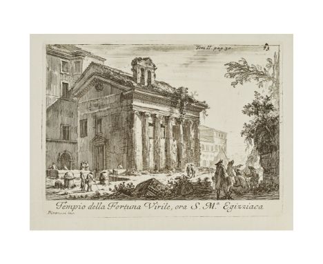
VENUTI, RIDOLFINOACCURATA, E SUCCINTA DESCRIZIONE TOPOGRAFICA DELLE ANTICHITÀ DI ROMA. ROME: Rome: Battista Bernabò e Giuseppe Lazzarini, 1763. First edition, 2 vols., 4to., interleaved throughout, with 1 engraved folding map, 96 engraved plates, 2 engraved headpieces and 2 vignettes, contemporary vellum, some wear to heads, tails of spines and to edges, covers with some staining (2)Note: One of the most important books on the topography of Ancient Rome in the 18th century, it contains 96 fine engraved plates including 19 by Giovanni Battista Piranesi. They were first published in his Varie Vedute of 1748. A complete catalogue of Venuti's works, complete lists of the members of the Roman Society of Antiquaries and of the Royal Society of Antiquaries of London is given at end of vol. 2. Both books with the ownership signature of Sir William Watson, FRS (3 April 1715 -10 May 1787), English physician and scientist and with the bookplate of the architect Percy B. Tubbs (1868-1933). The Directory of British Architects, 1834-1914, Vol. 2, p. 840 notes Tubbs' particular interest in collecting works on the topography of ancient Rome, and especially in the works of Piranesi.

LAWRENCE, T.E.CRUSADER CASTLES London: Golden Cockerel Press, 1936. 2 volumes, 4to, number 579 of 1000 copies, 2 folding map in sleeve, plates, contemporary brown half morocco by Sangorski & Sutcliffe, t.e.g., others uncut, joints slightly rubbed, sides slightly discoloured, slight chipping to head of one spine, slipcase
-
109198 item(s)/page