We found 109182 price guide item(s) matching your search
There are 109182 lots that match your search criteria. Subscribe now to get instant access to the full price guide service.
Click here to subscribe- List
- Grid
-
109182 item(s)/page


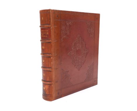
Lot 778
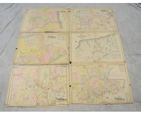
Kelly's Directory of Bristol 1972 together with further Bristol related books including The New Illustrated Guide to Clifton and Bristol with map by Norris Matthews circa 1880, a further Guide to Clifton, its Neighbourhood by John Taylor circa 1880, History of the Port of Bristol 1877 and The Concise Guide to Bristol and Suburbs 1878


![Heading: Author: [Nash, George C.]Title: Golfing in Ulster [Golfing in Northern Ireland (cover title)]Place Published: Belfas](https://cdn.globalauctionplatform.com/7cf593ca-3f54-412e-9fb0-a66d011b9ba8/27af9885-d060-4eef-8bf8-d301b4004546/468x382.jpg)
Lot 106
Heading: Author: [Nash, George C.]Title: Golfing in Ulster [Golfing in Northern Ireland (cover title)]Place Published: Belfast, IrelandPublisher:Tourist Information CentreDate Published: [c.1952]Description: 100 pp. Foreword by Sir William Neill. Illustrated from photographs; golf course map drawings. (8vo) original color pictorial wrappers. First Edition. Nice description of all Northern Ireland golf courses, including Royal Portrush and Royal County Down. Printed by W. & G. Baird, Ltd. D&J N1750. Provenance: From the collection of Joseph P. Garrity.Condition: Wrappers lightly worn; very good.

Lot 131
Heading: (Prestwick Golf Club)Author: Smail, David Cameron, editorTitle: Prestwick Golf Club, Birthplace of the Open: The Club, the Members and the Championships, 1851 to 1989Place Published: [Prestwick, Scotland]Publisher:[Privately printed]Date Published: [1989]Description: 238 pp. Profusely illustrated from photographs and other reproductions, some in color. (4to) original green padded leather, color pictorial cover label, lettered in gilt, map endpapers, all edges gilt, original acetate cover, slipcase. No. 229 of 250 hand-numbered copies. First Edition. History of the famed links on Scotland's Ayrshire coast. D&J S22390. Provenance: From the collection of Joseph P. Garrity.Condition: Light wear to slipcase and acetate; slight lean to spine; near fine.
Lot 136
Heading: (Ryder Cup - 1949 Program) Author: Title: [8th] International Ryder Cup tournament, Played at Ganton Course, Scarborough, 1949, official programPlace Published: Scarborough, England Publisher:Ryder Cup / Ganton Golf ClubDate Published: 1949Description: 64 pp. Illustrated from photographs and course map drawings. 20.8x25.3 cm. (8¼x10"), original saddle-stitched wrappers. The U.S. Team lead by Captain Ben Hogan defeated Great Britain 7-5.Condition: Moderately rubbed at wrapper edges, creasing along top edge of front wrappers, crease on rear wrapper corner, tiny chips or tears at edges; lacks perforated yellow cards on page one; some darkening to edges of page one; very good.
![Heading: Author: [Coopman, Edwin J.]Title: History of the San Francisco Golf ClubPlace Published: [San Francisco]Publisher:Sa](https://cdn.globalauctionplatform.com/7cf593ca-3f54-412e-9fb0-a66d011b9ba8/64f1084c-2ad4-4bf9-f105-1e64460eec3c/468x382.jpg)
Lot 27
Heading: Author: [Coopman, Edwin J.]Title: History of the San Francisco Golf ClubPlace Published: [San Francisco]Publisher:San Francisco Golf ClubDate Published: [1978]Description: 95, [1] pp. Foreword by the club president, W.A. Bentley. Illustrated from numerous photographs and other reproductions on orange and white paper; course map at the end. (Small oblong 4to) original rust-orange cloth, decoratively stamped and lettered in gilt. No. 241 of 1000 copies. First Edition. The club's course was designed by A.W. Tillinghast. D&J C19870.Condition: Previous owner's name on front endpaper; fine.
Lot 87
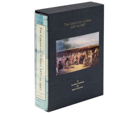
Heading: Author: Johnston, Alastair J. and James F. JohnstonTitle: The Chronicles of Golf: 1457 to 1857Place Published: [Cleveland]Publisher:[Privately printed]Date Published: [1993]Description: vii, 734 pp. Illustrated with 48 plates from photographs, paintings, drawings, facsimiles, engravings, maps, etc., most of which are in color; map endpapers showing the early golfing locations in Scotland. 27.8x20.8 cm. (11x8¼"), blue cloth-backed boards, spine lettered in gilt, pictorial jacket, slipcase with mounted color plate and lettered in gilt. No. 91 of 900 numbered copies. First Edition. Signed by both authors on the limitation page. The most comprehensive study of early literary references on golf. Developed by Alastair Johnston using a great deal of his own personal collection as reference. D&J J7660.Condition: Fine.
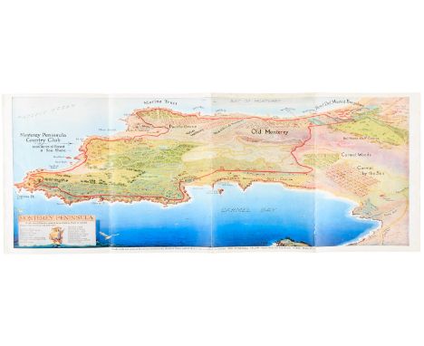
Lot 40
Heading: Author: Del Monte Properties CompanyTitle: Map of the Pebble Beach Golf Course and the Monterey Peninsula Country ClubPlace Published: Monterey & Carmel, CAPublisher:Del Monte Properties Co.Date Published: [c.1929]Description: Promotional folding leaflet, folded into 6 sections, containing a full-color printed map of the Monterey Peninsula Country Club showing the Pebble Beach Golf Course and all the immediate surrounding area. Other side with a black and white map of Pebble Beach, CA along with textual information and small photographic vignettes. 9x23" (unfolded). Scarce item containing an attractive and early color map view of one of the most famous and scenic regions in the world. Rare. Only 3 copies of this item on OCLC / Worldcat.Condition: A touch rubbed and creased; near fine.
![Heading: Author: Adamson, H[enry]Title: The Muses Threnodie; or, Mirthful Mournings on the Death of Mr. Gall. Containing a va](https://cdn.globalauctionplatform.com/7cf593ca-3f54-412e-9fb0-a66d011b9ba8/9918e262-424e-4496-8974-99072a2018a2/468x382.jpg)
Lot 1
Heading: Author: Adamson, H[enry]Title: The Muses Threnodie; or, Mirthful Mournings on the Death of Mr. Gall. Containing a variety of Pleasant Poetical Descriptions, Moral Instructions, Historical Narrations, and Divine Observations, with the most remarkable Antiquities of Scotland, especially of PerthPlace Published: PerthPublisher:Printed by George JohnstonDate Published: 1774Description: 2 volumes in 1. xxii, [2], 261, [3 blank]; 200 pp. Additional notes and observations on Perth by James Cant. Lacking the engraved folding map frontispieces. (8vo) 17.5x11.5 cm. (6¾x4½), period full calf, later rebacking, spine stamped in blind, red leather label. Second Edition. Originally published in 1638, Adamson's Muses Threnodie was the first book to contain a reference to the game of golf, in two lines of a poem that read "and yee, my clubs, you must no more prepare/to make your bals flee whistling in the aire." This second edition, published almost 150 years later, contains a footnote to these two lines and a reference to playing golf at Perth, where Adamson was born. This is the variant with the title page only for the first volume, without a volume number. Scarce. Murdoch p.10; D&M 140; D&J A3090. Condition: Rubbed, bookplate; lacking maps; very good.
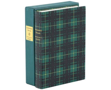
Lot 10
Heading: Author: Berry, Warner BottTitle: Scotsman's DreamPlace Published: San FranciscoPublisher:Privately Printed [at the Arion Press]Date Published: 2002Description: [6], 527 pp. Illustrated with golf course plans showing the complete and imaginative 18-hole golf course from drawings by Christopher Monti and Andrew Berry; frontispiece drawing by Andrew Berry; decorative map endpapers of the golf course for 2000 (front endpapers of the MacKenzie Map by Christopher Monti and rear endpapers by Darryl T. Roberson and Christopher Monti). 27.8x20 cm. (11x8"), tartan patterned cloth in green, black and yellow colors, spine lettered in yellow, green cloth slipcase with paper spine label. No. 876 of 1000 copies designed and produced under the direction of Andrew Hoyem with Blake Riley at the Arion Press. First Edition. Signed by the author in the colophon. An imaginative work that involves the three greatest golf course architects in the history of the game, A.W. Tillinghast, Alister MacKenzie, and Donald Ross. These men hold a secret "meeting of the minds" in March, 1933. They design the plans for the ultimate golf course to give to a wealthy Scotsman who is told not to have the course revealed and built until the year 2000. According to this work of fiction, these three greats want to prove to the golfing world of the new millennium that classic designs will always surpass all other designs, regardless of when they are built. D&J B15220.Condition: Fine.
![Heading: Author: [Bennett, Andrew]Title: The Book of St. Andrews Links, Containing Plan of Golf Courses, Descriptions of the](https://cdn.globalauctionplatform.com/7cf593ca-3f54-412e-9fb0-a66d011b9ba8/16ffc4f3-674e-4f5a-e88e-61c9abe02b6a/468x382.jpg)
Lot 9
Heading: Author: [Bennett, Andrew]Title: The Book of St. Andrews Links, Containing Plan of Golf Courses, Descriptions of the Greens, Bye-Laws of the Links, Regulations for Starting, Golfing Rhymes, &c.Place Published: [London]Publisher:Ellesborough PressDate Published: [1984]Description: [8], vi, [2], 80 pp. Illustrated with drawings, a photo, ads, and a folding color map in the back. (12mo) 18.3x12 cm (7¼x4¾"), full dark green morocco, brown spine, gilt-lettered, gilt-tooled calf cover label, marbled endpapers, all edges gilt, publisher's green cloth slipcase. No. 67 of 200 hand-numbered copies. Facsimile Edition. Signed on the limitation page by J. Stewart Larson, Captain of the Royal and Ancient Golf Club of St. Andrews, 1979-80. Originally published in 1898 with a small print run of 1000 copies. Bennett's book is one of the few primary sources of information on the Royal and Ancient (aside from Balfour's and Flemming's), providing the most definitive account of the evolutionary stages in the design, development, and growth of the courses, as well as their condition prior to 1898, the year in which major alterations were implemented. D&J B13300; D&M 700. Condition: Some wear to slipcase; fine.

Lot 122
Heading: (Pasatiempo Country Club - Map)Author: Santa Cruz Development Co.Title: General Plan for Pasatiempo, Country Club and EstatesPlace Published: Santa Cruz, CAPublisher:Olmsted Bros.Date Published: 1929Description: Hand-colored lithographed map of the Pasatiempo Golf Course and Country Club in Santa Cruz, California, in various shades of green and golden yellow. Plus, two inset maps, one a general guide of the area and a Key Map (both with Pasatiempo in green). Drawn by the Olmsted Brothers, Landscape Architects. 30.2x57.5 cm. (11¾x22¾") plus margins. Pasatiempo Golf Club is an 18-hole golf club located in Pasatiempo, Santa Cruz County, California. Designed by the famous English architect Alister MacKenzie, the course is famed for its breathtaking scenery and rich golf history. The course opened in September 1929 and Bobby Jones was in the first group to play it. MacKenzie claimed that it was his best layout, ahead of even Cypress Point and Augusta National, and his American home borders the sixth fairway. Pasatiempo is about an hour's drive from Cypress Point, a Monterey Peninsula neighbor to Spyglass Hill and Pebble Beach. Pasatiempo is a highly rated course, number 12 in Golf Magazine's "Top 100 Courses You Can Play 2006-2007" and 31 in Golf Digest's "2005 America's Greatest Public Courses". Golf Digest also named Pasatiempo Golf Club as one of the top 3 "Courses You Can Play in California" (along with Pebble Beach and Spyglass Hill). The magazine ranked Pasatiempo 71 in the "Top 100 Courses in the U.S. (private and public)", up 13 places over the 2003 ranking. A very scarce map of the home lots surrounding the course, only the second copy we have seen, and only two copies located by OCLC (UC Santa Cruz and the University of Guelph.Condition: Original folds, paper a bit wrinkled, old tape residue at upper corners; very good.
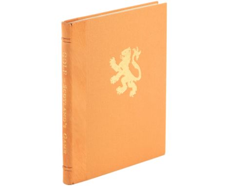
Lot 67
Heading: Author: Hamilton, DavidTitle: Golf: Scotland's Game - The St Andrews EditionPlace Published: KilmacolmPublisher:The Partick PressDate Published: 1998Description: [6], 269 pp. Profusely illustrated from reproductions, facsimile documents, paintings, photographs, golf course maps, etc., taken from old sources; folding facsimile 1815 map of Scotland and decoratively embossed leather bookmark, placed inside the rear pocket sleeve, as issued. Endpapers made at the Griffen Mill, Glastonbury, from grass cut from Leith Links (home of the world's first golf club). (4to) 27.5x22 cm. (11x8¾"), tan morocco-backed cloth, gilt rampant lion motif stamped on the front cover, spine lettered in gilt, publisher's tan cloth slipcase with gilt rampant lion stamped on a cover. No. 81 of 350 copies, bound in morocco at the Fine Bindery, Wellingborough. "The St Andrews Edition." First Edition. Signed by the author on the limitation page. D&J H4030. Provenance: From the collection of Joseph P. Garrity.Condition: Fine.

Lot 161
Heading: (USGA Program - 1946 Open Golf Championship)Author: Weisman, Russell, editorTitle: USGA 46th Open Championship, June 13-14-15, 1946, Canterbury Golf Club. Souvenir BookPlace Published: Beachwood, OHPublisher:USGA / Canterbury Golf ClubDate Published: 1946Description: 72 pp. Introductions from facsimile letters by Frank J. Lausche (Ohio Governor) and Thomas A. Burke (Cleveland Mayor). Illustrated from photographs and ads throughout; full-page course map. 28x21.5 cm. (11x8½"), original saddle stitched pictorial wrappers, front cover stamped in shades of blue, color ad on rear cover. Important and scarce USGA program for the 1946 U.S. Open, especially since this was the first time it was played after having been canceled four straight years starting in 1942 due to the war. An extra day was played after Byron Nelson, Lloyd Mangrum and Victor Ghezzi were tied at 284 after regular play. Lloyd Mangrum (1914-1973) would win the event, his only major championship win. With articles: "52 Years of the U.S.G.A."; Ten Commandments for Golf Galleries & How to Look at a U.S. Open by Grantland Rice; Canterbury, After 25 Years; Review of the 1940 Open; Ladies of the "Fore" by Claire Doran; Highlights on Earlier U.S. Opens by Francis Ouimet; a hole-by-hole description; New Golf School Takes Over by O.B. Keeler; short descriptions of several key plays in the tournament; and more. Provenance: From the collection of Joseph P. Garrity.Condition: Vertical crease throughout, small crease at lower corner of front cover, larger corner crease on rear; very good.


Lot 142
Archdall, Mervyn. Monasticon Hibericum: or a History of the Abbeys, Priories and other Religious Houses in Ireland. Dublin, printed by J. Wright of Dublin for Luke White, 1786. First edition. 4to. Stowe library copy with ink inscription on fly leaf. Folding engraved map and 18 plates, some ink annotations in Irish some slight browning, book plate of John Ynyr Burges, Parkanur, Tyrone on front pastedown, later endpapers, modern antique-style blind stamped calf. Provenance: Purchased at the Duke of Buckingham's sale of the Stowe library Feb.1849 by J. Y. Burges. The annotations in Irish in the text are likely those of Charles O'Conor (1764-1828 ) Irish priest and historical author, chaplain and librarian to the Marchioness of Buckingham. O'Conor, catalogued many manuscripts,including the Stowe Missal now in the Royal Irish Academy. John Ynyr Burges 1798-1889. Graduated MA from Brasenose College, Oxford. 1829, High Sheriff of Co. Tyrone and Justice of the Peace for Tyrone.


Lot 2
17th Century, John Speed, map of Connaught Attractive map of Connaught with inset town plan of Galway. “Performet by John Speede and are to be solde in Popes Head Alley against The Exchang by John Sudbury and George Humble, Anno Dominis 1610”. contemporary hand colouring, framed. 15¼ x 20¼in. (38.74 x 51.44cm)


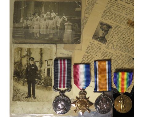
Lot 719
Military Medal group - MM GV (11278 Pte T Mullen 12/W.York R.), 1915 Star Trio (11278 Pte T Mullen W.York.R.). Comes with much original paperwork and newspaper cuttings (these have been laminated). At one point he was believed Killed In Action and the family received official notification of his death (this included) however he was recuperating in German Hospitals after laying Wounded within a few yards of the German Trenches for three days. Mullen of Newcastle finally Escaped to the Dutch Frontier after three days of travelling by night with an Australian companion Hughie West (MM) who had hid a compass and map in his clothing. The newspaper cuttings give a vivid account of Mullens escape form the Prison Camp. MM L/G 30/1/1920 POW/Escapers Gazette. A super group.


-
109182 item(s)/page