We found 109182 price guide item(s) matching your search
There are 109182 lots that match your search criteria. Subscribe now to get instant access to the full price guide service.
Click here to subscribe- List
- Grid
-
109182 item(s)/page

![x Bank of Hindustan Ltd., 100 rupee shares, 193[3], no.1504, attractive piece with underprint map of India, scrollwork at lef](http://lot-images.atgmedia.com/SR/1141/2883305/257-201351619726_468x382.jpg)
Lot 257
x Bank of Hindustan Ltd., 100 rupee shares, 193[3], no.1504, attractive piece with underprint map of India, scrollwork at left, brown, green seal, together with Travancore National & Quilon Bank Ltd., 50 rupee shares, 193[7], no.3143, brown and orange-brown with elephants at top centre, both with splits at folds, fine to very fine and both rare. (2) Vat Status: Import 5% View Terms & Conditions

Lot 25
MILLER (Edward) - The History and Antiquities of Doncaster and Its Vicinity with Anecdotes of Eminent Men, ed. Doncaster (1804), folding map frontis, eleven eng. plates, orig boards (detached), JACKSON (Charles), Doncaster Charities Past and Present, workshop 1881, photographic portrait frontis, further illustrations and folding pedigrees, orig. cloth; Borough of Doncaster, A Calendar To The Records, vol. II, vol IV Court Rolls of Doncaster, Ressington, Hexthorpe and Long Sandall (1900), Courtiers of The Corporation, Fletcher (J.S.), The History of the St. Leger Stakes, 1776-1901, London Hutchinson 1902, four coloured plates and other illusts. orig. cloth; FALCONER (James), The Charitable Endowments of The Town of Doncaster; origin, Progress and Present State, Part 1, The Hospital of St. Thomas the Apostle, London, 1836, orig. frontis and one eng. portrait plate, orig. Irish boards; Whaley (S.pub.), The History and Antiquities of Thorne, with some account of the Drainage of Hatfield Chase, 1829, 8vo. orig. printed boards with red Morocco spine; LANKESTER (Edwin), An Account of Askern and it's Mineral Springs, London 1842, folding map frontis, orig. boards; PHILLIPS (Ernest), The Story of Doncaster, London 1921, orig. dec. blue boards; NORWAY (Arthur), Highways and Byways in Yorkshire, illust. by Pennell & Thomson, London 1903, orig. cloth; STUART (J.A. Erskine), The Literary Shires of Yorkshire, London 1892, illust. orig cloth gt. (11)

Lot 36
JOHNS (C.A.) FLOWERS OF THE FIELD, ed. by Clarence Elliott, 1907, ninety two col. illusts, orig. green cloth, tog. with Lees (F.Arnold), The Flora of West Yorkshire, 1888, folding map, orig. green cloth, Hort (Arthur) The Unconventional Garden, 1928, orig. dec. cloth, and Moore (Thomas), The Clematis as a Garden Flower, 1872, illusts. orig. green cloth (4)


Lot 25
NORDEN (JOHN). "Speculi Britanniae Pars. A Topographicall and Historical description of Cornwall, By the perambulacon vien and deliniacon of John Norden.". extra engr strapwork title page dedication leaf, mileage chart, double page engr map, nine double page engr hundreds, and fourteen other engrs comp, cont calf, 4to, split and worn, 1728 contents clean, crisp, 18 prelim and 104pp comp, table and index in manuscript form, bookplate E.W. Wynne Pendarves.


Lot 78
Cervantes "The Life and Exploits of the Ingenious Gentleman Don Quixote de la Mancha", carefully revised and corrected by Charles Jarvis in 4 volumes, printed for William Miller, 1801, various engraved plates, including a folding map in volume 1, green stained tree calf, gilt rules, raised bands and pastedown to backstrips, but some wear to all four volumes, marbled end papers and all edges marbled, Lane, Edward William, "The Thousand and One Nights commonly called in England, The Arabian Nights' Entertainments...", in 3 volumes, numerous illustrations from original designs by William Harvey, published Charles Knight and Co, 1839, half vellum with marbled boards, gilt decorations to backstrip with red pastedown, Boccaccio, Giovanni "The Decameron", illustrated with photogravures from original drawings by Louis Chalon, London, The Navarre Society, 1921, white cloth, gilt rules, decorations etc, 2 volumes and, The Holy Bible, Oxford University Press, 1845, full leather, decorated cloth, all edges gilt, "The Works of Rabelais", ills, Gustav Dore, Chatto and Windus, full stained green calf, raised bands, gilt decoration, pastedown (11)


Lot 577
Victorian Map by Edward Standford: A Geological Survey map sheet no.103 N.E. New Series Sheet 27. Featuring Hartlepool. 10 section maps on linen bound in hard cover. Together with Stanford`s Map of the river Thames. Paris Circulation Metro, Autobus and Tramways map. Together with 2 reprints Ordinance Survey maps for Shrewsbury, Dorking and Kingston.


Lot 94
Catherwood, Frederick (1799-1854) Views of Ancient Monuments in Central America, Chiapas, and Yucatan. London: by Owen Jones for Catherwood, 1844. Folio, illustrated with chromolithographic and gilt-printed title page, one map, and twenty-four of the twenty-five hand-colored lithographic plates, lacking plate seventeen: Interior of the Principal Building at Kabah; title page spotted, plates with some minor edge dust and corner chips, occasional spotting, with the original boards, both detached, spine detached and fragmentary, with loss of leather, 21 1/2 x 14 1/2 in.
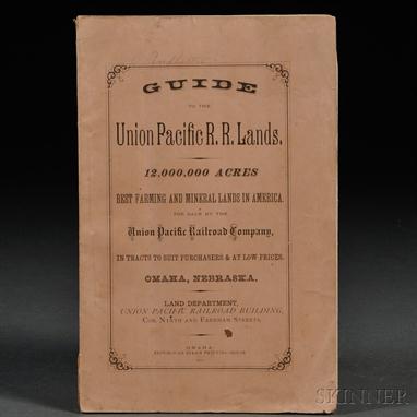
Lot 184
Guide to the Union Pacific R.R. Lands. 12,000,000 Acres. Omaha: Republican Steam Printing House, 1870. Octavo, original printed pink paper wrappers, frontispiece map, large folding map of the first 200 miles of the railway, the Nebraska land grants from 1862 to 1864; 36 pages, stab sewn; some spotting, folding, and water stains, maps with slight tears, 9 x 5 7/8 in.
![King James Bible, Old and New Testament in English, Authorized Version. London: Robert Barker, [1611/1613]. Folio, "She&](http://lot-images.atgmedia.com/SR/2124/2881882/217-2013515131741_468x382.jpg)
Lot 217
King James Bible, Old and New Testament in English, Authorized Version. London: Robert Barker, [1611/1613]. Folio, "She" Bible, with the typographical error (he for she) corrected in Ruth 3:15 this copy; lacking the general title page, the map, and the final leaf, Nnnn4; title page within elaborate woodcut compartment for the New Testament present in this copy, calendar printed in red and black; this copy contains the Apocrypha and Speed`s Genealogies, it is printed in seventy-two lines per column, see Darlow & Moule 322; ESTC S122066; bound in contemporary, or slightly later boards, very small fragments of the original general title adhering to the inside of the front board, binding and sewing failing, with old repairs, text leaves starting, faults to text leaves including tears, stains, long ink inscription on the verso of the New Testament title page, 15 1/2 x 10 1/4 in.

Lot 222
Kircher, Athanasius (1602-1680) China Monumentis. Amsterdam: Joannes Jansson a Waesberg & Elizeum Weyerstraet, 1667. Folio, engraved title, engraved vignette on typographical title, typographical title torn with 1 1/2 x 2 1/2 in. C-shaped lacuna to the blank margin; full-paged engraved portrait of Kircher in his library; large folding map of China, large folding table of Eastern languages torn and repaired, two full-paged engraved plates of Syriac inscriptions; large folding map of Asia torn with slight reparable loss, tape repairs, on ink spot, detached from book; full-paged plate of the miraculous cross of Saint Thomas in India; eleven text engravings mainly depicting people; full-paged engraving of the Mughal Emperor; three text engravings of animals; full-paged standing portrait of Kam Hi, the second emperor of the Manchu Qing dynasty; two full-paged engravings of typical regional Chinese types, each with six frames; full-paged standing portrait of the Jesuit astronomer Johann Adam Schall von Bell (1592-1666); full-paged standing portrait of Matteo Ricci and Li Paulus Magnus; two full-paged engravings of a Japanese woman with a bird in two different domestic settings; text engraving of an Indian religious rite; full-paged engraving of a Chinese temple; folding engraving of a Chinese painting; text engraving depicting a Japanese religious rite; text engraving of the Buddha on a lotus; full-paged engraving of a seated many-armed Buddha on a lotus with Sanskrit inscription; two repeated text engravings: the Japanese and Indian rites; full-paged anatomical Brahma man engraving; ten text engravings illustrating a Hindu Brahman tale, the first engraving, signed, Mm, pasted over the original imprint, which was mistakenly printed upside down; five full-paged engravings of Sanskrit; three large text engravings depicting a dragon fighting a tiger, seven mountains with reference to Ursa Major, and a carved idol; text engraving of a baby floating on a small raft in the middle of a lake; ten text engravings of botanical subjects; text-size engraving printed on an otherwise blank sheet extraneous to the collation (considered full-paged: Qqq); five text engravings of animals and birds; text engraving of an underground kiln; full-paged engraving of a bridge; text engraving of the great wall, with an elephant; text engraving of two large bells; eight text engravings of Chinese characters; text engraving of a calligrapher; lacking Hh2, the middle leaf of the index, and Hh4 ?blank. Plate count: engraved title; portrait of Kircher; two folding maps; two folding engravings; twenty-one full-paged engravings; and fifty-nine text engravings; bound in later leather, boards dry, rebacked, text leaves 15 x 9 1/2 in. Occasional spotting and tears.

Lot 233
Lewis, Meriwether (1774-1809) and William Clark (1770-1838) History of the Expedition Under the Command of Captains Lewis and Clark, to the Sources of the Missouri, thence Across the Rocky Mountains and Down the Columbia to the Pacific Ocean. Philadelphia: Bradford and Inskeep, 1814. Two volumes; first edition; with five full-page maps, and only a torn fragment of the large folding map, in uniform contemporary marbled sheepskin, slightly abraded, with the original red labels on the spines, end caps chipped; contents spotted throughout, 4 3/4 x 8 1/2 in. (2).

Lot 236
Lincoln, Abraham, Assassination; Benjamin Pitman (1822-1910) compiler. The Assassination of President Lincoln and the Trial of the Conspirators. Cincinnati: Moore, Wilstach, & Baldwin, 1865. Octavo, first edition, engraved frontispiece with portraits of the accused conspirators, map, defective publisher`s cloth binding, title and preliminaries water stained, occasional spotting to contents, 9 1/2 x 5 3/4 in.

Lot 329
The Philippines, Four Volumes: Foreman`s The Philippine Islands, London: Sampson Low, Marston, et al., 1890, in decorative publisher`s cloth. Major Younghusband`s The Philippines and Round About, New York: Macmillan, 1899, in publisher`s red cloth, illustrated, unopened. Ramon Reyes Lala`s The Philippine Islands, in publisher`s decorative cloth binding, illustrated. Map of Philippine Islands and Adjacent Seas, New York: Bien & Co., 1898, large folding map housed in publisher`s cloth folder. (4).

Lot 330
The Pirates Own Book, or Authentic Narratives of the Lives, Exploits, and Executions of the Most Celebrated Sea Robbers. Portland: Sanborn & Carter, 1844. Octavo, illustrated with many wood engravings of pirate characters and adventures, in publisher`s brown blind-stamped cloth, with the title blocked on the spine in gold with the skull and cross bones, somewhat worn, one signature sprung, 7 1/4 x 4 1/2 in. [with] Lewis H. Morgan`s League of the Ho-De-No-Sau-Nee, or Iroquois, Rochester: Sage & Brother, 1851, first edition, illustrated with frontispiece, large folding map of the Iroquois nation (New York state), and numerous text illustrations, many full-paged, folding table, etc.; in worn publisher`s cloth, blocked in blind, with gilt-stamped spine, sewing supports attaching back board broken, de-cased, binding worn and rubbed, head cap torn, 9 1/4 x 5 3/4 in. (2).

Lot 348
Vernet, Carle (1758-1835) Tableaux Historiques des Campagnes d`Italie. Paris: Auber, 1806. Folio, portrait of Napoleon on a horse; twenty-three plates of battles from the Italian campaign; a hand-colored double page map of Italy; one plate of a battle in Egypt; a separate sub-title for the coronation of Napoleon with portrait medallions of the Emperor and Josephine; an account of the campaigns in Germany, and a supplement to the Italian and German campaigns illustrated with four additional full-paged plates, some scattered spots and minor foxing, in contemporary marbled leather, gold tooled, front joint starting to crack, corners worn, a.e.g., red spine label, 19 3/4 x 13 in.


Lot 438
Beers, Frederick W. (1839-1933) Atlas of Long Island, New York. New York: Beers, Comstock, & Cline, 1873. Folio, with more than 100 hand-colored maps, including a map of the state of New York; another of Manhattan and Brooklyn; a five-panel folding map of Long Island (with tears and repairs), a double-page map of Brooklyn; and many others, including multiple maps for all major communities, including Flatbush, Jamaica, East New York, the Rockaways, Canarsie, Shelter Island, Long Island City, Astoria, Flushing, Hempstead, Oyster Bay, Brookhaven, Islip, and so on; some old repairs, thumbing, tears, in contemporary three-quarter leather and marbled paper boards, rubbed, with some damage, structurally intact, 12 1/2 x 15 1/2 in.
![Caribbean Islands. Heinrich Scherer (1628-1704) Archipelagus Americanus. [from] Atlas Novus. Munich, c. 1700. Small folio dou](http://lot-images.atgmedia.com/SR/2124/2881882/441-201351513277_468x382.jpg)
Lot 441
Caribbean Islands. Heinrich Scherer (1628-1704) Archipelagus Americanus. [from] Atlas Novus. Munich, c. 1700. Small folio double-page engraved map, two sheets joined at the center, slight toning along the join, 15 1/4 x 10 5/8 in., the sheet. This map covers the southernmost tip of Florida, the Bahamas, Cuba, Hispaniola, Jamaica, Puerto Rico, the Lesser Antilles, and northern parts of Panama, Colombia, and Venezuela, including the mouth of the Orinoco River. A finely drawn illustration of sea trade between Europe and the islands appears in the upper right hand corner.

Lot 442
Cary, John (c. 1754-1835) Cary`s New Map of England and Wales with Part of Scotland. London: Publish`d June 11th 1794 by J. Cary, Engraver & Map-seller, No. 181 Strand. First edition, large quarto, engraved title and dedication, the hand-colored gridded General Map, and seventy-six hand-colored full page panel maps for each grid section, numbered 1-81, excluding numbers 62, 63, 71, 72, and 80, all of which contain only open ocean [seventy-seven maps in total], 85 pages of index, and three pages of subscribers; bound in contemporary speckled boards, edges and spine gilt, front board re-hinged, back board detached, some offsetting, 11 3/4 x 9 1/2 in.

Lot 443
Coastal New England. Levinus Hulsius (1546-1606), After John Smith (1580-1631) New England Die mercklichsten dheile, also genennet Durch den Durchl. Frankfurt, 1617. Single sheet folio engraved map, matted and framed, with restoration along two edges, and the adjacent outer rules done in pen facsimile, cleaned, old folds just barely visible, 13 3/4 x 11 3/4 in. This map was published in the German translation of John Smith`s New England in 1617. It is one of the earliest maps to focus exclusively on the New England coast.
-
109182 item(s)/page