We found 108737 price guide item(s) matching your search

Refine your search

Year

Filter by Price Range
  • List
  • Grid
  • 108737 item(s)
    /page

Lot 245

A silver and blue enamelled cigarette case, engraved map of Michigan on reverse, 6 2/3" high, 7.5oz troy approx

Lot 373

A framed silk escape map of France printed on a silk handkerchief, given to Major Charles Farrell MC before the D-Day landings, 24" x 22"

Lot 413

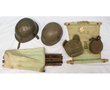
Visit to Portsmouth, May, 1907. Visit of Colonial Premiers and the Houses of Parliament to Portsmouth, privately printed for publication, time table, text pages of key areas visited, fold-out map of dockyard and Whale Island, fold-out list of ships of home fleet at Portsmouth 1907, seven tissue guarded real photographs of submarines, the 'Dreadnought', etc., bound in full dark-blue calf leather, richly decorated in gilt, silk endpapers, all edges gilt, 19.5cm x 13cm (1)

Lot 425

A canvas map case, a WW2 helmet and a water bottle, together with a folding wooden and canvas campaign chair.

Lot 397

Map size approx 24.5 x 20cm.

Lot 845

Victorian and later letters and invoices, WWI postcards, map of the GWR system, Japanese book of poetry and sundry ephemera.

Lot 826

A late 17th century John Norden map of Sussex, 'Augmented by John Speede' English text verso, 39.5cm by 51cm

Lot 931

Local interest, a 19th century map of the Isle of Wight engraved by B Baker, 18cm by 22.5cm, together with a map of Portsmouth, 20cm by 25cm, and a plan of Portsmouth, 31cm by 20cm

Lot 639

A Chinese shaped rectangular porcelain dish decorated with stylized map and character symbols, on circular foot, marks to base, 32.5cm diameter, together with five assorted blue and white plates including one with decorative symbols

Lot 312

A framed map of the local Gloucester area featuring the GWR railway, roads etc. including Stroud, Dursley, Cirencester etc. marked to lower left corner 'made by Herry Perry finished on the feast of St John at the Latin Gate 1930', Perry designed Art Deco posters and maps for the London Underground circa 1928 to 1937, 34x31cm

Lot 216

Twenty five 18thC maps including road map examples

Lot 310

Collection of ephemera to include circa 1922 photograph album Richmond Park, Rome etc London District railway map on cloth and Chambers Guide to Sussex

Lot 294

Four plans /maps relating to the Gloucester Lunatic Asylum (Horton Road) comprising a 1902 map of the area, a site plan inscribed J C Cooke, Clerk of Works, May 6th 1889, a further drawing with J C Cooke's signature and Secretary of State stamp, and 1900 Gloucester boundaries map (largest 73cm x 104cm)

Lot 217

Framed Cruchley's county map of Gloucester showing railways, stations, roads etc. circa 1880, 58x50cm

Lot 315

A 1939 linen backed road map of India

Lot 127

A Welsh clasp Bible rebound in full leather, 1st January 1819. The Bible dates from the mid to late 18th century and still retains its map of Israel and the surrounding area. Teithlau Plant Israel Yn Yr Anialwch. Rhodd Rhis.t. Morys Est LICC, i'r Cymry

Lot 138

METAL MICHELIN MAP OF UK GARAGE SIGN AND POLLING STATION SIGN

Lot 468

After John Norden. 'SUSSEXIA', a 17th century hand-coloured engraved map of Sussex by William Kip, 23 x 39.5cm, 'DEVONIAE' also by Kip, 'DORSET SHIRE' by Robert Morden, 'CORNWALL from the BEST SUREVYS 1748', 'ENGLAND & WALES with the Islands of Garnsey, Jersey & C.' by Herman Moll, a road map of Salisbury and Southampton, all framed and glazed, together with three unframed maps 'THE INVASIONS OF ENGLAND AND IRELAND' by John Speed, 'BRITANNIA Saxonica' and 'NORTHUMBIAE Comitatus olim sedes OTADINORUM'. (9)

Lot 118

A quantity of damask and other table linen; soft goods; a 19th Century sampler map of England and Wales (poor condition).

Lot 510

An antique JOHN STEED hand coloured map of the Isle of Wight

Lot 511

An antique hand coloured map by BLAEU of Huntingdon

Lot 512

Antique map of the Isle of Wight and Hampshire

Lot 574

Isle of Wight, Speed (John), Wight Island, sold Sudbury & Humble, [1614], hand coloured engraved map, inset plans of Southampton and Newport, num. armorials, 40cm x 53cm

Lot 613

Dutch School 18th Century-A pair of portraits, both half-length:- she with powdered wig adorned with flowers wearing a turquoise dress with lace fringes and holding a fan and a flower;he wearing a powdered wig and navy blue jacket holding a map and resting on a leather bookoils on canvas, each 82 x 64cm. [2]

Lot 422

Two clocks, a metal figure of a seated dancer, two Wedgwood-style white jugs with moulded Grecian figures, Tins framed map of Suffolk, a mirror and other items

Lot 268

TWO TALISKER 10YOTwo bottles of Talisker 10 Year Old Single Malt Scotch Whisky. One Taisker 10 Year Old with Map Label. 70cl. 45.8% abv. Label with a few marks. Level mid-neck. Together with one Talisker 10 Year Old. 70cl. 45.8% abv. In original carton. Level mid-low neck. Excellent condition. 2 bottles.

Lot 529

Leather cylindrical map case, 36cm, another similar; and two leather pouches, (4).

Lot 456

J Gibson, an engraved colour map of Persia, 29 x 33cm.

Lot 124

MEMORABILIA: T.C. GOTCH.A collection of T.C. Gotch memorabilia, including two visiting cards, five Royal Institute of Painters in Watercolours invitations (one signed), a Newlyn Boy Scouts lecture delivered by T.C. Gotch & a silk map, once the property of Gotch's granddaughter, Deirdre MacLellan.Provenance: Deirdre MacLellan, the artist's granddaughter.

Lot 295

Silver map of the United Kingdom, London 1977, issued by The Council of the Protection of Rural England, the silver plate engraved and incorporating county shields, 55x 36cm

Lot 296

Silver map of the world, London 1977, issued by the Royal Geographical Society, engraved with nautical images, 37x 56cm

Lot 302

A Bartholomew and Son Ltd world wall map, dated 1986, from The Map Room at the London School of Economics

Lot 409

A 1949 map of Southern Rhodesia from The Map Room at the London School of Economics

Lot 524

A 1940's Swedish Economic map of Sweden from The Map Room at the London School of Economics

Lot 608

A map of the population distribution of South Africa in 1970, from the Map Room at the London School of Economics

Lot 58

A framed reproduction map of Lancashire

Lot 347

A map of The County of Westmorland dated 1974 framed

Lot 354

A framed map entitled 'A Map of the County of Westmorland as it was on the 31st day of March in the year of our Lord 1974' and a similar smaller framed map of Westmorland

Lot 174

JOHN OGILBY Antiquarian map titled 'The Continuation of the Road from London to Holy Head', c.1725, 32cm x 44cm

Lot 175

ROBERT MORDEN Antiquarian map of Buckinghamshire, with later hand colouring, 41cm x 34cm

Lot 176

EMMANUEL BOWEN Antiquarian map titled 'The Road from Nottingham to Grimsby in Lincolnshire', plate number 206 from Britania Depicta c.1720, 18cm x 11cm

Lot 177

L. OVERTON Antiquarian map with later hand colouring of Staffordshire and Cheshire, 37cm x 48cm

Lot 178

AN UNSIGNED ANTIQUARIAN MAP TITLED 'MAGNAE BRITANNIAE ET HIBERNIAE TABVLA' with hand coloured and hand tinted later editions (undated)

Lot 270

A CASED SET OF EARLY 20TH CENTURY BARTHOLOMEW'S MAPS of England and Wales to include thirty seven sheets and two Lake District Ordnance Survey maps and a Dartmore Ordinance Survey map

Lot 716

W and A.K. JOHNSTON 'Australia', double page engraved map hand coloured 52cm x 65cm Five further similar depicting England and Wales (unframed) together with Frances St Clair Miller, 'Worton' etching, an engraved view of St Michael's Mount and an engraved view of Lincoln Cathedral

Lot 562

Greenwood & Co map of the East Riding of York 1831 - 32 with view of Beverley Minster

Lot 74

Six maps: 'Turkey in Europe' (with) inset map of Candia drawn and engraved by J. Rapkin with illustrations by H. Warren and engraved by J. Rogers; 'The Grecian Archipelago' according to the British Admiralty Survey drawn by Augustus Petermann, engraved by G. H. Swanston x 2; Plan of Ancient Athens, after Kiepert; Grecia Antica by T. Duvotenay and Macedonia all mounted but not framed and two engravings of London landmarks, all in good condition (8)

Lot 343

Crown Ducal Emu Australian wines ceramic flask to Commemorate the Coronation of Their Majesty's King George VI & Queen Elizabeth May 12th 1937, depicting a map of the world and a scarce Monk & Glass custard powder tin

Lot 810

Cooper (J. Fenimore). History of the navy of the United States of America, 2 volumes, 2nd edition, published Philadelphia, Lea and Blanchard, 1840, engraved map frontispiece to each, original cloth gilt, 8vo

Lot 819

Folding map, Official Railway Map of England & Wales, prepared and published at the Railway Clearing House, 1899, in original leather wrappers, 120cm x 94cm approx.

Lot 827

Pardoe (Julia). The Beauties of the Bosphorus, 1838, engraved portrait frontispiece, additional engraved title, map and seventy-eight engraved views after William Bartlett (complete), contemporary half morocco, 4to

Lot 161

A framed map of Edinburgh, together with another, 45 x 35cm (2)

Lot 1116

Saxton and Hole engraved map of the North Riding of Yorkshire with early hand colouring, for Camden's Britannia, together with a collection of miscellaneous photographs and watercolours by J Freeman including ''Sandsend'', J F Rennie, depicting Sandsend etc (qty)

Lot 151

Mahogany framed print with water side scene together with modern framed map of Staffordshire (2)

Lot 656

John Blaeu (1596-1673) Leicestrensis Comitatvs (Leicestershire), hand tinted 17th Century map which originally appeared in Le Theatre du Monde or L'Atlas Maior, 39 x 50 cm

Lot 134

Assorted Wedgwood collectable's and an armorial framed printsTo include Wedgwood Jasper Ware trinket boxes, Wedgwood Queens Ware bowl, Burleigh Ware George V commemorative cup, Wedgwood tapering glass paper weight, three framed armorial prints, framed map "The road London to Buckingham", and an 18th Century pewter plaque, qty

Lot 86

A reproduction framed map, "The Kingdom of England"The coloured map flanked by various figures including a citizens wife, a countryman and a gentlewoman, map size 37x29cms

Lot 140

A collection of architectural prints of Chester, 20th CenturyTo include Northgate Street, Watergate Street, amusing cartoons of badgers playing musical instruments, hand tinted map of Shropshire publish by Longman, London, further prints etc. (9)

Lot 585

Three mid 19th century Atlas's by Samuel Lewis, Topographical Dictionaries of England and Wales, Counties of Ireland and a general map of the Kingdom and A Topographical Dictionary of Scotland, published by S. Lewis and Co., 13 Finsbury Place, South, each cloth bound

Loading...Loading...
  • 108737 item(s)
    /page

Recently Viewed Lots