We found 109198 price guide item(s) matching your search

Refine your search

Year

Filter by Price Range
  • List
  • Grid
  • 109198 item(s)
    /page

Lot 85

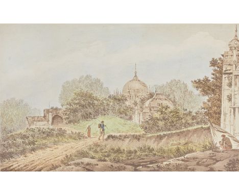
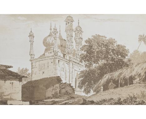
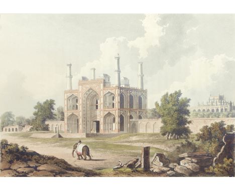
FORREST (CHARLES RAMUS)A Picturesque Tour Along the Rivers Ganges and Jumna in India, FIRST EDITION, 24 hand-coloured aquatint plates, one uncoloured aquatint map, coloured aquatint vignette on title-page, vignette on p.191, occasional off-setting, publisher's green cloth gilt, g.e., hinges starting, spine ends frayed, light stains on upper cover, later slipcase [Abbey Travel 441; Tooley 227], folio (400 x 302mm.), R. Ackerman, 1824This lot is subject to the following lot symbols: •• Zero rated for VAT, no VAT will be added to the Hammer Price or the Buyer's Premium.For further information on this lot please visit Bonhams.com

Lot 87

HODGES (WILLIAM)Select Views in India, drawn on the Spot, in the Years 1780, 1781, 1782, and 1783, and Executed in Aqua Tinta, FIRST EDITION, SECOND ISSUE, single issue edition with title and text in English and French, 48 HAND-COLOURED AQUATINT PLATES, one hand-coloured engraved folding map, corners of title and a few leaves neatly repaired at corners, occasional damp-staining and light foxing, modern quarter morocco [Abbey Travel 416; Tooley 264], folio (590 x 430mm.), for the Author, [1785-88]Footnotes:HAND-COLOURED COPY OF ONE OF MOST IMPORTANT SERIES OF AQUATINT VIEWS OF INDIA, which includes the first printed depiction of the Taj Mahal (shown in the background of plate 15 'A View of the Fort of Agra').William Hodges (1744-1797) made his name as a draughtsman whilst accompanying Captain Cook on his second voyage to the Pacific. In 1779, under the patronage of Warren Hastings, he travelled to India and remained there for six years, making visits to Calcutta, Cawnpoor, Lucknow, Allahabad, Agra, and Fatehpur Sikri. On his return he was made a Royal Academician and published the present work in parts between 1785 and 1788 'making a substantial contribution to the British perception of India's past... Alexander Humboldt [recording] that the sight of Hodges' Indian views was one of the inducements which led to travel' (ODNB).This lot is subject to the following lot symbols: •• Zero rated for VAT, no VAT will be added to the Hammer Price or the Buyer's Premium.For further information on this lot please visit Bonhams.com

Lot 88

HODGES (WILLIAM)Select Views in India, drawn on the Spot, in the Years 1780, 1781, 1782, and 1783, and Executed in Aqua Tinta, FIRST EDITION, FIRST ISSUE, single-volume issue with title-page, dedication and text in French and English, one engraved map and 48 aquatint plates printed in bistre, by and after Hodges, small tears neatly repaired to 2 text leaves, lacking three leaves of text (2 from 'Views of Gwalior'; one from 'View of Firozeabad'), occasional very light spotting, modern quarter morocco [Abbey Travel 416; Tooley 264], folio, for the Author, [1785-88]Footnotes:THE FIRST SUBSTANTIAL SERIES OF VIEWS OF INDIA, including the first depiction of the Taj Mahal, shown in the background of plate 15, 'A View of the Fort of Agra'. Abbey suggests that this is the first issue, with the plates uncoloured and fewer leaves of text.This lot is subject to the following lot symbols: •• Zero rated for VAT, no VAT will be added to the Hammer Price or the Buyer's Premium.For further information on this lot please visit Bonhams.com

Lot 140

THE DISTRICT RAILWAY MAP OF LONDON 7TH EDITION, WORN CONDITION

Lot 90

MIXED LOT: VARIOUS ASSORTED WORLD STAMPS, ORDNANCE SURVEY MAP ETC

Lot 359

John Sibbick (20th/21st Century)/Two Ankylosaurs/gouache, 19cm x 26.5cm/Note: Commissioned by the Natural Geographic Society in 1992 for their map 'North America in the Age of Dinosaurs' published January 1993/Provenance: The Estate of Anthony J Beeson CONDITION REPORT: ARR Artist's Resale Right may apply to the sale of this lot if the hammer price is the equivalent of 1000 Euros or more, incurring an additional fee. For further information please ask Chorley's or visit www.dacs.org.ukCondition information is not usually provided in the description of the lot but is available upon request; the absence of a condition report does not imply that a lot is without imperfection

Lot 611

Turner (Capt. S) 'Account of an Embassy to the Court of the Teshoo Lama in Tibet; …through Bootan and part of Tibet', 4to, London, 1800. Ex-lib in modern library cloth binding, fldg. map and 13 plates (all present) as called for (1)/Provenance: The Estate of Anthony J Beeson CONDITION REPORT: Condition information is not usually provided in the description of the lot but is available upon request; the absence of a condition report does not imply that a lot is without imperfection

Lot 226

ROBERT MORDEN MAPS ETC. An early 18th century, framed map of Oxfordshire by Robert Morden, 44 x 37cm. Also, a similar unframed Morden map of Oxfordshire, a Morden Map of Monmouth & an early map of Irlandia by Ortelius.NOTE: We cannot ship this lot by our postal shipping service due to its size, fragility, weight or value. We also cannot ship large or disparate multiple lot purchases unsuitable for posting. Buyer to collect or arrange a carrier. Our recommended carrier is MBE Plymouth: Telephone +44 (0) 1752 257224 or info@mbeplymouth.co.uk  

Lot 306

Metal model of WWII fighter plane, 45cm across and map (2).

Lot 347

Framed Landseer print, George Morland print, two framed map prints, Durham print and four prints of engravings (9).

Lot 681

A collection of vintage pictures and prints to include a map of the Côte D'Azure; a Victorian religious diptych; a pair of Scottish loch scenes etc

Lot 254

A Saxtons map of Northumberland and a Saxtons map of Durham

Lot 481

A quantity of various military related items to include various figures, plates, a Civil Defence Corps Welfare Arm Band, a map of Surrey, a leather mug with crest, a small Japanese teapot, etc.

Lot 1527

° ° Kalendario Manual y Guia de Forasteros en Madrid, 24mo, red morocco, with coloured engraved map of Spain, lacking portraits, 1817, bound with Estado Militar de Espana, lacking map of Madrid, 1817; Enrique, Jacobo Bernardino - Pablo y Virginia, 12mo, calf, Madrid, 1798; Gramatica de La Lengua Castellana…2nd edition, Seville, 1799; Cervantes Saavedra, Miguel de - Novelas Exemplares, 3 vols, 12mo, calf, Madrid, 1799 and one Novelas Exemplares, 2nd edition, vol. 1 only, engraved frontis, Perpignan, 1816, (7)

Lot 1650

Johannes Blaeu (1571-1638), coloured engraving, Map of Cantabrigiensis (Cambridgeshire), German text verso, full sheet 50 x 59cm

Lot 1651

Johannes Blaeu (1571-1638), coloured engraving, Map of Oxonium (Oxfordshire), Dutch text verso, full sheet 50 x 59cm

Lot 383

TWO BOXES OF ROYAL MEMORABILIA AND PIANOFORTE SHEET MUSIC to include a collection of Orbis World War II magazines, an Official Souvenir Programme from a June 1923 visit to Walsall Hospital by H.R.H The Prince of Wales, a 1944 map of Poland, a map of Europe 1916/18, early 20th Century sheet music, etc (2 boxes)

Lot 867

MIXED LOT: FRAMED MAP OF GREAT BRITAIN, VARIOUS ASSORTED PICTURES ETC

Lot 857

Isaac Tirion (pub.) "New Map of the Barony of Breda" by J. Keizer, 1739. Provenance: Kunsthandel Borzo, 's-Hertogenbosch, inv. no. 69480.

Lot 100

Framed Map of the Cambridge Colleges published by Pictorial Maps Ltd

Lot 117

Frames Map of Cambridge and assorted pictures and prints

Lot 275

Christopher Saxton coloured map of Norfolk with inset plan of Norwich, 38 x 51 cm, framed and glazed

Lot 443

Jules DE BRUYCKER (1870-1945)Etching from the folder Gens de chez nous 18/100, signedEts uit de map Gens de chez nous 18/100, gesigneerd8.5 x 13.5 cm

Lot 519

Jan Burssens & Nic Van Bruggen 4 vrouwenAlbum with 4 etchings and poems, n° 28/50, signed in pencil.Map met 4 etsen en gedichten, n° 28/50, in potlood getekend.

Lot 863

Folder Signature with lithographs including ao Bervoets, Franky DCMap Signature met lithografiën oa Bervoets, Franky D.C.

Lot 518

Hugo Claus & Camille D'havé emblemataFolder with poems by Hugo Claus with etchings by Camille D'HavéMap met gedichten van Hugo Claus bij etsen van Camille D'Havé

Lot 465

Jules DE BRUYCKER (1870-1945)Etching from folder Gens de chez nous, n° 28/100, signed.Ets uit map Gens de chez nous, n° 28/100, gesigneerd.19 x 23 cm

Lot 2514

British Isles. Moll (Herman), A New Map of Great Britain. According to the newest and most exact observations, Thomas & John Bowles, and John King (1720), engraved map on two conjoined sheets, with contemporary outline colouring, inset map of Shetland and Orkney Islands, picture frame cartouche, compass rose, and descriptive text, 102.5 x 62.5cm Paper with some creases.Approx 3cm tear from top edge at 1 o'clock, 3cm tear from bottom edge at 5 o'clock.Some spotting, principally to English Channel area.Inside of glass to same area appears grubby.Framed and glazed.Appears not to be stuck down.

Lot 2002

Gostling, William: A Walk In And About The City Of Canterbury, With Many Observations not to be found in any Description hithero published. The Second Edition, Canterbury; Printed by Simmons and Kirkby; 1777, with artists portrait frontispiece and advertisment by Hestor Gostling, fold-out plan and and map, rebound calf over marbled boards, 8vo. (1)

Lot 2006

Kirby, John: The Suffolk Traveller. First Published By Mr. John Kirby, Of Wickham-Market, Who took an actual Survey of the whole County, In the Years 1732, 1733, and 1735, The Second Edition, London: Printed for J. Shave, at the Stationer's Arms in the Butter-Market, Ipswich; and sold by T. Longman, in Pater-noster Row, London. 1764, eight-fold county map delineated with contemporary hand-colouring and four strip maps, tan leather spine and corners over marbled boards, 8vo. (1)

Lot 2024

Harris, John: The History Of Kent, In Five Parts..., London: Printed And Sold by D. Midwinter, at the Three Crowns in St. Paul's Church-Yard. 1719, Volume I. (no further volumes were printed due to the death of Harris), two engraved portrait frontispieces, folding map, single and double page plates, bound in panelled calf with gilt banded spine, bookplate for Cecil George Savile Foljambe, 1st Earl of Liverpool and with previous owners notes to endpapers, folio. (1) Re-calfed.With the usual bumps and wear to corners and spine.Shelfwave to bottom edge.Obvious split to paste-down end paper, which can be seen in online images.Crease and repair to opening “To The King”.Creases and expected spotting throughout.Map in good order, with the usual creases and has possibly been restuck at some point.

Lot 2041

Gage, John: The History and Antiquities of Suffolk, Thingoe Hundred, Published By John Deck, Bury St Edmunds, and Samuel Bentley, Dorset Street, 1838, thick 4to, 1st edition, hand-coloured engraved map, numerous plates, plans and illustrations, 1/2 morocco with gilt title to spine. (1)With errata to introduction page and page 538.

Lot 2045

Shrubshole, William :The History and Antiquities of Rochester and Its Environs: Embellished with Copper-Plates, Rochester: Printed And Sold BY T. Fisher; Sold Also By S. Crowder, Bookseller In Pater-Noster Row, London, 1772, 8vo, calf, folding map as frontispiece, together with Fussell, L Esq: A Journey Round the Coast of Kent, London: Published By Baldwin, Cradock, And Joy, 47 Paternoster-Row, 1818, rebound 1/2 green calf with marbled boards, 8vo., Paris, W.D. and Shaw, W.F.: A Dictionary Of The Kentish Dialect And Provincialisms In Use In The County Of Kent, London: 1887, tan 1/2 calf with marbvled boards, 8vo., and Hutchinson, John: Men Of Kent And Kentishmen. Canterbury: 1892 Subscription Edition, 1/2 leather with marbled boards, 8vo. (4)

Lot 2048

Green, R: The History, Topography, and Antiquities, of Framlingham and Saxsted, 1834, 1st edition, engraved frontis with folding map, 1/2 tan morocco with marbled boards, 8vo., together with A Concise Description Of Bury Saint Edmunds, 1827, gilt tooled tan leather binding, 8vo, Haslewood, Rev. Francis: The Monumental Inscriptions, In The Parish of Saint Matthew, Ipswich, Suffolk, Privately Printed 1884, original cloth 8vo., Hannah, Ian C.: The Heart Of East Anglia, Illustrated by Edith Brand Hannah, circa 1915, green gilt cloth, 8vo., Waller, Ambrose J.R.: The Suffolk Stour, 1957, red cloth gilt, 8vo. and Dutt, William A.: Highways and Byways in East Anglia With Illustrations By Jospeh Pennell, 1904. (6)

Lot 2059

Kirby, John: The Suffolk Traveller, Who Took An Actual Survey Of The Whole County. In The Years 1732, 1733, and 1734. Woodbridge: Printed And Sold By Smith And Jarrold, no date, folding map to frontis, rebacked calf with marbled boards, 4to, together with Cromwell, Thomas Kitson: Excursions In The County Of Suffolk... Forming A Complete Guide For The Traveller And Tourist. London: Printed For Longman, Hurst, Rees, Ormes, And Brown: J. Greig, Upper Street, Islington; And P. Youngman, Witham, And Maldon, Essex, 2 vols, 1818 & 1819, full gilt tooled black morocco, pott 8vo. (3)

Lot 2067

Rawlinson, Richard: The History and Antiquities of the Cathedral Church of Rochester. London: Printed for E. Curll, at the Dial and Bible near St. Dunstan's Church in Fleet-Street, 1717, re-bound new calf with gilt title, crown 8vo., together with Dearn, Thomas, Downes Wilmot: An Historical Topographical And Descriptive Account Of The Weald Of Kent, With Eight Engravings And A Map, Cranbrook: 1814 first edition, later calf with gilt title and marbled boards, 8vo. and Holloway, William: The History Of Romney Marsh From Its Earliest Formation To 1837, London: John Russell Smith,1849, tan cloth bound with gilt title, medium 8vo. (3)

Lot 245

A large assortment of prints and other decorative pictures, including a map of Berwick and prints from the Wallace Collection (a lot)

Lot 36

Ionian Bank Share Cetrificate, Specimen, framed; together with a small collection of old mining share certificates, Ivanhoe Gold, Valentine Gold, Menzies Consolodated Gold Mine etc; also a map of Kalgoorlie Region for Prospectors (9)

Lot 41

Six varied maps, modern reproductions, including map of the World, all in identical gilt frames 49cm x 56cm

Lot 43a

After John Senex (1648-1740, A map of Africa, hand coloured engraving, with inscription and dedication to Sir Isaac Newton, drawn and engraved by I. Senex, 70cm x 99cm

Lot 222

Jean COVENS & Corneille MORTIER (XVIII) "map" - Weight: 3.50 kg - Sizes: Cadre H=710mm L=700mm Carte H=520mm L=510mm - Condition: at first sight - good condition - no restoration - no repair - Author / artist: Jean COVENS & Corneille MORTIER (XVIII)

Lot 224

Jean COVENS & Corneille MORTIER (XVIII) "map" - Weight: 3.50 kg - Sizes: Cadre H=710mm L=700mm Carte H=520mm L=510mm - Condition: at first sight - good condition - no restoration - no repair - Author / artist: Jean COVENS & Corneille MORTIER (XVIII)

Lot 226

Nicolas SANSON D'ABBEVILLE (1600-1667) "map" - Weight: 1.25 kg - Sizes: Cadre L=410mm H=480mm carte L=220mm H=300mm - Condition: at first sight - good condition - no restoration - no repair - Author / artist: Nicolas SANSON D'ABBEVILLE (1600-1667)

Lot 227

Map of Luxembourg +- 1710 - Weight: 1.95 kg - Sizes: Cadre H=550mm L=620mm Carte H=350mm L=430mm - Condition: at first sight - good condition - no restoration - no repair

Lot 470

Part hand coloured map depicting Asia.

Lot 294

A 17th Century Robert Morden hand coloured engraved map of Nottinghamshire, framed

Lot 161

A WW2 medal, various military buttons, security labels, British Army map reading protractor etc.

Lot 280

A roll down map of Great Britain and Ireland (Relief and Communications)

Lot 311

A Philips' South America political map

Lot 6

A vintage leather map case initialled J.C.R.

Lot 757

A rolled wall map of the world and a rolled wall map of part of Hertfordshire

Lot 57

Kernstück mit 2 Tabletts und einer Schale, 7 Teile, Mexiko, 2. H. 20. Jh., 925er Silber, gemarkt "MAP Sterling 925 Hecho en Mexico" sowie Adlermarke mit Nr. 61, teils leicht bombierte Wandung mit Volutenfüßen und -henkel, Deckel mit Balusterknauf, jeweils umlaufender Randbordüre aus reliefplastischer Floral- u. Rocailleornamentik, H. Kanne: ca. 26 cm, L. Tablett mit Handhabe: ca. 53 cm, Gesamtgewicht: ca. 4865 g.

Lot 4309

A boxed brass chart/map magnifying glass, lens marked "George Australia 1901"

Lot 1141

A Map of Cheshire, photo reprints, Dodworth prints, etc:- One Box.

Lot 329

A Meteorite galvanised Masthead clear map, serial number C37448, clear Fresnel glass and carry handle, no internals, 55cm.Ex Coastal Steamer Labrica, these lamps were removed by the skipper, Lincoln Stott, when the nav lights were upgraded.

Lot 330

A Meteorite galvanised Masthead clear map, serial number C37730, clear Fresnel glass, 34cm and a Port lamp, serial number P124904, clear Fresnel glass, 34cm (2).Ex Coastal Steamer Labrica, these lamps were removed by the skipper, Lincoln Stott, when the nav lights were upgraded.

Lot 466

An Atari XEGS system (serial No A1 793005452), with manual, keyboard (serial No R1784 002654), with manual, power supply, joystick and Atari XE System light gun, also including Flight Simulator II with handbook, manual, aircraft control and map, also including a game manual for Missile Command and a factory sealed copy of Food Fight - TO BE SOLD ON BEHALF OF MONKEY WORLD 

Lot 418

Miscellaneous collection of books to include Vitalogy: An Encyclopedia of Health and Home, by E. H. Ruddock, 1930; Aristotle's Masterpiece, London: Clifton Chambers, n.d. [c.1900]; Rupert Magic Painting Annual, Daily Express, 1960; Map & Guide of London, Francis Chichester, c.1950s, and others, condition varied, sold as found with all faults, together with a circa 1960s BOAC Speedbird advertising fan of card & bamboo construction, well-preserved (9)

Lot 425

Miscellaneous collection of books & ephemera to include Clayton Clark, Joseph, "Kyd" (Illus.). The Character Sketches of Charles Dickens, London: Raphael Tuck & Sons, n.d., 24 colour lithographic plates of characters, illustrated boards, contents loose, some pale spotting; Paisleys. Highland Dress, illustrated catalogue with appendix in rear wallet, ninth edition, n.d. [c.1940]; The Works of Aristotle, Containing his Masterpiece, London: Clifton, Chambers & Co., n.d. [c.1900], a popular sex manual and midwifery book that was first published in 1684; an Edwardian/WW1 album; a 1950s scrapbook; a small quantity of cigarette/trade cards; a small quantity of vintage menus; Isle of Man: 160 Art Photos with Map & Guide, Douglas: The Star Bazaars, n.d. [c,1910s]. Condition varied, sold as found with all faults

Loading...Loading...
  • 109198 item(s)
    /page

Recently Viewed Lots