We found 109182 price guide item(s) matching your search
There are 109182 lots that match your search criteria. Subscribe now to get instant access to the full price guide service.
Click here to subscribe- List
- Grid
-
109182 item(s)/page


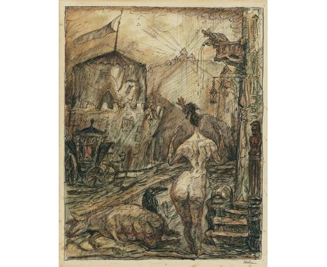
Lot 118
Alfred KubinAschermittwoch Aquarell und Tuschfederzeichnung auf Bütten (Rückseite einer Katasterkarte) 39,5 x 31,6 cm Unter Glas gerahmt. Unten rechts mit Tusche signiert 'Kubin', unten links mit Bleistift betitelt 'Aschermittwoch'. - Im Rand gebräunt und mit vereinzelten Stockflecken.Hoberg Mappe V/II/2 und Raabe 168 (die nach dieser Zeichnung entstandene Lithographie)ProvenienzPrivatsammlung, WestfalenWie kaum einem Künstler der Moderne gelingt es Alfred Kubin die sozialen Realitäten des Alltags mit den unterschiedlichsten Fiktionen und Traumbildern organisch ineinander übergehen zu lassen. In einem Brief an seinen Künstlerfreund Fritz von Herzmanovsky-Orlando bezeichnet sich Kubin 1908 selbst als „Organisator des Ungewissen, Zwitterhaften, Dämmerigen, Traumartigen“ und tatsächlich offenbaren sich seine Werke dem Betrachter als abgründiges Amalgam von Gesehenem und Unsichtbarem (Brief vom 9. Januar 1908, in: Fritz von Herzmanovsky-Orlando, Sämtliche Werke Bd. VII. Der Briefwechsel mit Alfred Kubin. 1903 bis 1952, Salzburg/Wien 1983, S. 10). Zwischen Apokalypse und Karneval präsentiert sich der Aschermittwoch in unserer prachtvoll aquarellierten Tuschezeichnung als Limbus für Mensch und Kreatur. Auf der Schwelle von Rausch und Affekt, Buße und Erlösung ist der Karneval ein in vielfacher Hinsicht naheliegendes Thema für den Künstler, steht das Fest doch sinnbildlich für die Verwandlung und liefert als irdischer (Alb-)Traum par excellence eine ideale Folie für Kubins Inszenierung unterschiedlicher Wirklichkeitsebenen. Auffällig ist nicht nur der für Kubin so typische Detailreichtum, der die einzelnen Bildelemente und dargestellten Wesen in einer Fülle phantastischer Erzählungen aufgehen zu lassen vermag, sondern auch die zeichnerische Dichte. Meisterhaft setzt Kubin Hell- und Dunkeltöne und untereicht die obsessive Drastik des Sujets mit jedem einzelnen Strich auch auf formaler Ebene. In dieser Qualität und Größe präsentiert sich das vorliegende Blatt, nach der auch eine Lithographie für die Mappe „Traumland II“ (Hrsg. von Fritz Gurlitt, Berlin 1922) erschien, als bildgewaltiges Meisterwerk eines der bedeutenden Zeichner des 20. Jahrhunderts. Alfred KubinAschermittwoch Watercolour and pen and ink drawing on laid paper (reverse side of a cadastral map) 39.5 x 31.6 cm Framed under glass. Signed 'Kubin' in India ink lower right, titled 'Aschermittwoch' lower left. - Marginal browning and with few foxmarks.Hoberg Mappe V/II/2, and Raabe 168 (lithograph after this drawing)ProvenancePrivate collection, WestphaliaThere is scarcely another artist of the modernist period who succeeds like Alfred Kubin in organically merging the social realities of everyday life with the most varied fictions and dream images. In a 1908 letter to his friend and fellow artist Fritz von Herzmanovsky-Orlando, Kubin refers to himself as “organiser of the uncertain, ambiguous, shadowy, dream-like” (Letter of 9 January 1908, in: Fritz von Herzmanovsky-Orlando, Sämtliche Werke vol. VII. Der Briefwechsel mit Alfred Kubin. 1903 bis 1952, Salzburg/Vienna 1983, p. 10) and his works do in fact reveal themselves to their viewers as an enigmatic amalgamation of the seen and the invisible. In our ink drawing magnificently toned with watercolours, Ash Wednesday presents itself as something between the Apocalypse and Carnival, as a limbo for human beings and creatures. On the threshold between intoxication and passion, penance and salvation, Carnival is an obvious theme for the artist in many respects: after all, the festival serves as a symbol of transformation and, as the earthly dream (or nightmare) par excellence, it provides an ideal foil for Kubin to stage different levels of reality. What is striking is not just Kubin's very typical wealth of detail, which is able to make the individual elements of the picture and the depicted creatures culminate in an abundance of fantastic narratives, but also the graphic density. Kubin has masterfully placed his light and dark tones and used every single stroke to also underscore the obsessive explicitness of his subject on a formal level. In this quality and grandeur, this sheet - which also provided the source for a lithograph for the portfolio “Traumland II” (publ. by Fritz Gurlitt, Berlin 1922) - presents itself as a visually overpowering masterwork by one of the 20th century's most important draughtsmen.
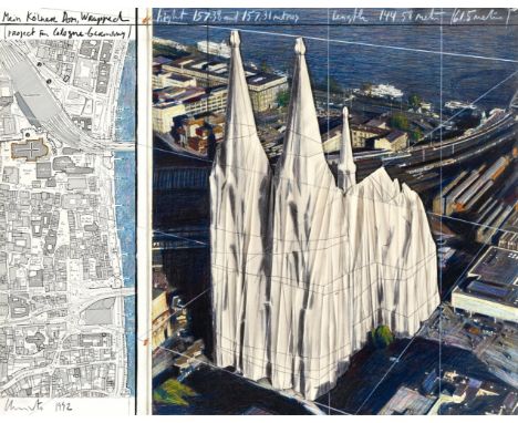
Lot 188
ChristoMein Kölner Dom, Wrapped Bleistift, Kohle, Pastell-, Wachskreide, Fotokopie, Stoff, Bindfaden und Karte auf Karton auf Holz 56 x 71 cm. Unter Plexiglas gerahmt. Signiert, datiert und betitelt 'Mein Kölner Dom, Wrapped (Project For Cologne-Germany) Christo 1992' sowie mit weiteren Angaben. Rückseitig auf dem Holz signiert '© Christo 1992'. - Mit Atelierspuren.Mit schriftlicher Bestätigung vom Studio Christo, New York, per E-Mail vom 29.03.2017.ProvenienzPrivatsammlung, HessenDie vorliegende Arbeit ist die Vorlage zur gleichnamigen Edition von 1992, erschienen bei Edition Torsten Lilja, Stockholm (Schellmann/Koddenberg 161).„Christos Verhüllung leitet die Suche nach der ‚verlorenen' Realität ein. Und selbst dort wo eine Verhüllungsaktion nicht zustande kommt oder nicht zustande kommen kann und im Stadium der vorbereitenden Zeichnungen und Collagen verharrt, wirkt sich schon die „Realität" aus. Es ist ja die Wirklichkeit, die etwas „Realität" werden lässt oder nicht. Christos Kunst ist von Anbeginn realitätsbezogen. Der Künstler setzt sich - und seine Kunst fordert zum Nachvollzug auf - mit der Wirklichkeit des Alltags auseinander, mit einer Wirklichkeit, die eine Vergangenheit hat und eine Zukunft haben wird." (Gerhard Kolberg, Christos Zeichnungen, in: Christo, Projekte in der Stadt 1961 - 1981, Ausst.Kat. Museum Ludwig, Köln 1981, S.25). Eine besondere Verbundenheit des Künstlers mit der Stadt Köln besteht bereits seit 1961, als im Hafen der Stadt Christos und Jeanne-Claude erstes gemeinsames Projekt „Gestapelte Ölfässer und Verhüllungen im Hafen" entsteht.1980 entwickelt Christo anlässlich des 100-jährigen Jubiläums zur Vollendung des Kölner Doms eine erste Idee zur Verpackung des Doms, die im Rahmen der Ausstellung „Zeitgenössische Künstler sehen den Kölner Dom" im Kölnischen Kunstverein präsentiert wird. 1992 greift Christo die Idee zur Verpackung der Kathedrale mit Mein Kölner Dom, Wrapped erneut auf. Seine Verhüllung des Doms ist bereits von Anfang an als Konzept beabsichtigt, das in unserer collagierten Ausführung mit Stoff und Faden die konkreteste Form seiner Verwirklichung erfährt. ChristoMein Kölner Dom, Wrapped Pencil, charcoal, pastels, wax crayon, photocopy, cloth, thread, and map on card on wood 56 x 71 cm. Framed under plexiglass. Signed, dated, and titled 'Mein Kölner Dom, Wrapped (Project For Cologne-Germany) Christo 1992' and additional information. Signed '© Christo 1992' verso on wood. - Traces of studio.Accompanied by a written confirmation from Studio Christo, New York, via email dated 29.03.2017.Provenanceprivate collection, HesseThe present work is the reference for the edition of the same name from 1992, published by Edition Torsten Lilja, Stockholm (Schellmann/Koddenberg 161).'Christo's wrapping initiates the quest for a "lost" reality. And even in those places where a wrapping action falls through or can't be realised, thus remaining in the state of preparatory drawings and collages, "reality" already has an impact. It is reality after all which makes something "real" or not. Christo's art refers to reality right from the outset. The artist explores the reality of everyday life, a reality that has a past and will have a future and his art urges this comprehension.' (Gerhard Kolberg, Christos Zeichnungen, in: Christo, Projekte in der Stadt 1961 - 1981, exhib.cat. Museum Ludwig, Cologne 1981, p.25). A special affinity to the city of Cologne already exists since 1961, when Christo and Jeanne-Claudes' first joint project Stacked Oil Barrels and Dockside Packages was created in the harbour. In 1980, on the occasion of the 100th anniversary of the completion of Cologne Cathedral, Christo developed first ideas on the wrapping of the cathedral which are presented on the occasion of the exhibition 'Zeitgenössische Künstler sehen den Kölner Dom' at Kölnischer Kunstverein. In 1992, Christo takes up the idea to wrap the cathedral with Mein Kölner Dom, Wrapped once again. His shrouding of Cologne Cathedral is an intentional concept right from the outset encountering its most concrete form of realisation in our collaged version with cloth and thread.
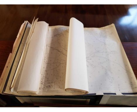
Lot 408
ROSS, Horatio (1801-86). "Journal of Sporting Adventures in India from 1858 to 1862." Oblong 4to (263 x 355mm.). Original manuscript journal on c. 60 leaves (first text leaf repaired at upper edge with some loss, a few leaves torn or repaired with occasional insignificant loss). Contemporary black half morocco gilt (rubbed, some old repairs). Provenance: Horatio Ross (signature on front pastedown). A FINE MANUSCRIPT JOURNAL, BY A RENOWNED SPORTSMAN AND PHOTOGRAPHER, of a hunting trip in the Bengal region of India, incorporating original watercolours and drawings throughout illustrating bear, wild boar and tiger hunting (sometimes on elephant-back). Perhaps more appealing to the modern sensibility, however, are the watercolours of extensive Indian landscapes, rich with wildlife, and the detailed depictions of life in camp which do little to belie certain stereotypes of an idealised "Raj". The Journal also includes a full-page original map of "Singowlee" [i.e. Singrauli] and a "Bird's Eye View of the District of Mirzapore". The Journal opens: "In February 1858, I was staying in Calcutta reading for my examination in Hindee. [I had an] invitation from Lane, who was then at Burdwar, to join him & some others in an expedition. Having passed the examination, I started with Peacock by train from Howrah for our destination, the rest of the party having started before us. After proceeding about eighty miles, we reached the station where we were to get out of the train & found two very smart palanquins & bearers waiting for us, & were informed that we would have to go about fourteen miles. This was the first time I had ever travelled in one of these contrivances; I, however, after a short time rather approved of it ..." Born at Rossie Castle, near Montrose in Angus, Horatio Ross, in addition to being a renowned sportsman and marksman, was a pioneer of amateur photography, being an early exponent of the processes of the Daguerrotype and Calotype, and was a founding member of the Photographic Society of Scotland.

Lot 396
MERCATOR, Gerard (1512-94). Tab. VI. Asiae. Arabiam Felicem, Carmaniam ac Sinum Persicum comprehendens. [Utrecht: François Halma, c. 1695]. Hand-coloured engraved map of the Arabian Peninsula, title within decorative [second state] cartouche, sea monster, 340 x 470mm., unframed. Tibbetts Arabia in Early Maps 39.

Lot 412
SPEED, John (1552-1629). Cambridgeshire described with the devision of the hundreds, the Townes situation, with the Armes of the Colleges of that famous Universiti: And also the Armes of all such Princes and noble men as have heertofore borne the honorable tytles & dignities of the Earldome of Cambridg. [London:] John Sudbury and G. Humbell[sic],1610 [but 1616]. Fine hand-coloured engraved map of Cambridgeshire, title within baroque cartouche surmounted by Royal coat-of-arms, inset bird's-eye-view of Cambridge, 4 academic figures, one holding the scale, College coats-of-arms in the side borders, family coats-of-arms in lower border, Latin text on verso (engraved frame shaved at sides), 382 x 520mm., framed and glazed. Chubb XXIVa: "The Latin edition of Speed's atlas of Great Britain and Ireland is extremely rare; it was not until 1918 that the British Library obtained a copy." A fine example of one of the most decorative and sought-after of all Speed's county maps.
![SPEED, John (1552-1629). Wight Island. [London:] John Sudbury and G. Humbell[sic], [1611 or later]. Hand-coloured engraved m](https://cdn.globalauctionplatform.com/90ffa5c4-0670-4589-81bb-ac7e00fac987/fa7349a3-6e35-4eb5-9983-ac7e011206dd/468x382.jpg)
Lot 414
SPEED, John (1552-1629). Wight Island. [London:] John Sudbury and G. Humbell[sic], [1611 or later]. Hand-coloured engraved map of the Isle of Wight, title within baroque cartouche, inset bird's-eye-views of Newport and Southampton, coats-of-arms, galleons and sea monster, English text on verso (lightly stained at centrefold), 380 x 505mm., framed and glazed. Chubb XXII (8).
![[DRAYTON, Michael (1563-1631) & William HOLE (d. 1624)]. Surrey ... Sussex. [London: 1612 or later]. Engraved allegoric](https://cdn.globalauctionplatform.com/90ffa5c4-0670-4589-81bb-ac7e00fac987/1c725cf6-2192-4884-87f0-ac7e010f8aaf/468x382.jpg)
Lot 365
[DRAYTON, Michael (1563-1631) & William HOLE (d. 1624)]. Surrey ... Sussex. [London: 1612 or later]. Engraved allegorical map including London, Surrey and Sussex, numbered 257 in upper margin (lightly browned except for a band about an inch wide at centrefold, a few small ink spots), 252 x 330mm., framed and glazed. Extracted from Michael Drayton's Poly-olbion (1612-22).
Lot 367
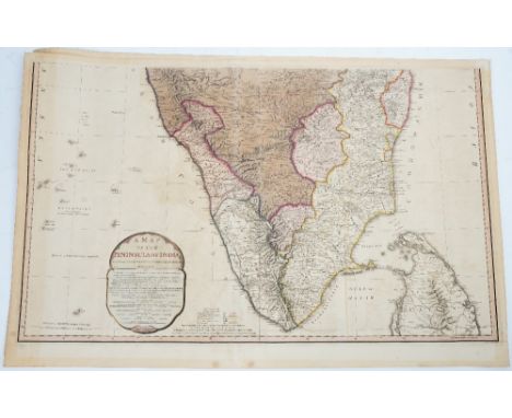
FADEN, William (1749-1836). A Map of the Peninsula of India from the 19th Degree North Latitude to Cape Comorin. London: 1792. Hand-coloured engraved map on 2 sheets (lightly but evenly browned), each sheet 490 x 805mm., unframed. The map is colour-coded by hand to delineate the territorial holdings as explained in a key at the foot of the southern sheet. Red regions represented areas held by the British, largely under the control of the British East India Company. Purple regions were those under the influence of the Raja of Mysore, a kingdom ruled in the late-18th century by Haider Ali and Tipu Sultan, who were known for inciting various rebellions against the British. The holdings of the Marhatta are coloured in green and the Nizam in orange. The territories in yellow were under the rule of the Nawabs of the Carnatic who succeeded in resisting British colonization until the early-19th century. Territories in blue were under the control of the Kingdom of Travancore, which came under the rule of the British East India Company after a treaty in 1795. (2)

Lot 375
GREENWOOD & CO. (publisher). Map of the County of Southampton. From an Actual Survey made in the Years 1825 & 1826 by C. & I. Greenwood. London: 1829. Large hand-coloured engraved map of Hampshire and the Isle of Wight, wood-engraved vignette of Winchester Cathedral (lightly spotted and browned), 575 x 695mm., framed and glazed.
Lot 386
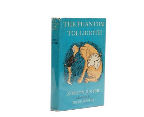
JUSTER, Norton (b. 1929). The Phantom Tollbooth. London: Collins, 1962. 8vo (221 x 150mm). Half title, illustrations by Jules Feiffer, some full-page. Original blue cloth, spine lettered in silver, dust-jacket with price of 15s. unclipped, map endpapers printed in blue (some chipping, mainly to head and foot of backstrip). FIRST ENGLISH EDITION of this "beguiling contemporary fantasy about a little boy named Milo who didn't know what to do with himself" (from the turn-in) which was first published in New York in 1961.

Lot 341
CASSINI, Giovanni Maria (1745-1824). L' America. Secondo. Le ultime osservazioni divisa ne' suoistati principali. Rome: 1788. Hand-coloured engraved map of the Americas and including New Zealand, fully hand-coloured allegorical vignette, routes of three Cook voyages coloured in pink and yellow, 335 x 458mm., unframed.

![[BLAEU, Joannes (1596-1673)]. Hertfordia Comitatus. Vernacule Hertfordshire. [Amsterdam: c. 1648]. Hand-coloured engraved ma](https://cdn.globalauctionplatform.com/90ffa5c4-0670-4589-81bb-ac7e00fac987/3fb6853c-8ae5-4023-bd9b-ac7e010e9348/468x382.jpg)
Lot 330
[BLAEU, Joannes (1596-1673)]. Hertfordia Comitatus. Vernacule Hertfordshire. [Amsterdam: c. 1648]. Hand-coloured engraved map of Hertfordshire, figural baroque cartouche and scale, coats-of-arms, Dutch text on verso (lightly spotted and stained), 380 x 500mm., framed and glazed. Chubb LXI. With 4 other maps including one of Surrey and one of Buckinghamshire. (5)
Lot 357
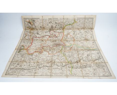
CRUCHLEY, George Frederick (1797-1880). Cruchley's Environs of London Extending Thirty Miles from the Metropolis. London: 1825. Large hand-coloured engraved map of London and surrounding area, on 35 sections mounted on linen (some light browning, some repairs on verso), 880 x 905mm., unframed. Howgego Printed Maps of London 299(1).

Lot 413
SPEED, John (1552-1629). Suffolke described and divided into Hundreds, The situation of the fayre towne Ipswich shewed, with the Armes of the most noble families that have been either Dukes, or Earles both of that Countie as also of Clare. [London:] George Hu[m]ble, 1610 [but 1611 or later]. Hand-coloured engraved map of Suffolk, title within baroque cartouche flanked by figures of Quintus Petillius Cerialis and Boadicea, inset bird's-eye-view of Ipswich, coats-of-arms, galleon, English text on verso (re-margined at sides with slight cropping to left engraved frame), 378 x 507mm., unframed. Chubb XXII (17).
![[BLAEU, Joannes (1596-1673)]. Surria Vernacule Surrey. [Amsterdam: c. 1662]. Hand-coloured engraved map of Surrey, baroque t](https://cdn.globalauctionplatform.com/90ffa5c4-0670-4589-81bb-ac7e00fac987/ab54f02e-66e7-40a3-97de-ac7e010e9c52/468x382.jpg)
Lot 391
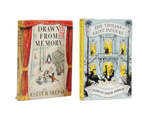
LEIGH FERMOR, Patrick (1915-2011). The Violins of Saint Jacques. A Tale of the Antilles. London: John Murray, 1953. 8vo (216 x 138mm). Half title, wood-engraved illustrations (some very light mainly marginal spotting). Original green cloth, map endpapers, dust-jacket with price unclipped (head and foot of backstrip a little frayed). FIRST EDITION of the author's only novel. With E. H. Shepard's Drawn from Memory (London, 1957, illustrations by E. H. Shepard, original cloth, dust-jacket, FIRST EDITION). (2)
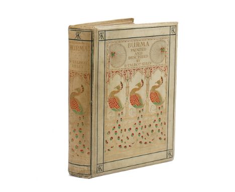
Lot 420
TALBOT KELLY, Robert (1861-1934). Burma Painted & Described. London: Adam and Charles Black, 1905. 4to (267 x 205mm). Half title, 75 coloured plates by R. Talbot Kelly, folding map at the end with route marked in red (some very light spotting). Original elaborate pictorial buckram gilt, top edges gilt, others uncut, red silk marker (lightly stained). NUMBER 40 OF 300 "EDITION DE LUXE" COPIES SIGNED BY THE AUTHOR.


Lot 81
Publication Commemorating the Visit to HMS Dreadnought in June 1908 of His Excellency the Prime Minister of Nepal, fine gilt tooled leather bound book, with silk lining to the interior of the covers. Rear pocket with printed map. Gilt edged pages with black and white images and tracing paper covers to each with printed details. Generally good condition.

Lot 190
Fascinating "Plaene des Schlachtfeldes von Koniggratz" 15 large coloured folding boards of the battle ground of Koniggratz,(pivotal battle in the war between Prussia and Austria in 1866) possibly used as a tactical or war gaming item. Scale is detailed enough to identify individual buildings and other features. Covers front and rear and title label present. Possible produced by the Prussian General Staff in Berlin (see details of incomplete item in Australian National Library) and date believed c.1870, unclear whether any map boards missing. Generally good condition. very rare.
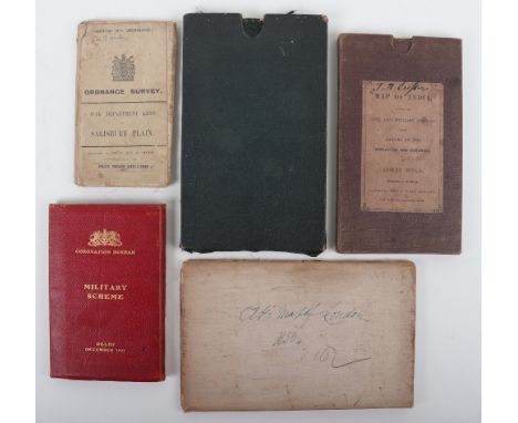
Lot 186
Collection of Mainly 19th century Maps, Map of India shewing Civil and Military Stations, James Wyld 1852 (large linen map in slipcase. New & Imperial Map of India, Major James Rennell, 1831, large folding map in green slipcase. Coronation Durbar Military Scheme Delhi December 1911 Schemes and Orders for Military Arrangements at Delhi.. Maps and Appendices as called for apart from one issued separately, (red leather binding, together with original ticket "Admit one Person Enclosure B.", The Circuiten No 1 London 1850 Guide for Cab Fares, Fredericks & Salisbury Plain 1914 (5)


Lot 78
Book – Life With The Esquimaux – A Narrative of the Arctic Expedition in Search of Survivors of Sir John Franklin’s Expedition, by Captain Charles Francis Hall, published by Sampson Low, son and Marston 1865. Coloured plates, map to rear (torn) and black and white illustrations. Beautifully leather bound.


Lot 73
Books – History of Steam Navigation by Kennedy 1905, beautifully leather bound example with gilt edge pages. Published by Charles Birchall Limited, Liverpool 1905; The World Inhabitants or Mankind Animals and Plants by G T Bettany, published by Ward, Lock & Co London 1888; The Living Races of Mankind Volume 1 published by Hutchinson & Co; Canadian Pictures by the Marquis of Lorne, published by the Religious Tract Society with illustrations to rear and fold out map etc; Indian Pictures Drawn with Pen and Pencil by Rev W Urwick. Various conditions. (5 items)

Lot 187
Two Original Great War Maps of Gallipoli, One of Kurija Dere, 1:20,000 1915, with Anzac Cove named, full colour linen c.75cms x 60cms, modest stain, else very good condition. Second map headed Gallipoli and dated 1915 reprinted at the Survey Dep Egypt 1:250,000 c.60cms x 50cms, linen vgc (2)

Lot 185
Collection of 19th Century Military Maps, including Map of Egypt & Suez Canal with full descriptive letterpress 1882 (W.H.Smith & Son). Similar of Afghanistan 1878 and Russo Turkish Frontier 1877, Bartholomew's Special large scale War Map of the Soudan.. With enlarged map of Khartoum 1885 & Bacon's War Map of Egypt including The Soudan (folds torn, others good condition) (6)

Lot 287
PARKER PENS (19) - 4 vintage (1960s-early 70s) Blue Parker fountain pens: 1 Parker 45, made in USA, with brushed Stainless Steel cap, chrome trim and half hooded nib; 1 Parker 45 with gold trim and half hooded nib; 1 Parker 17 with gold trim and hooded nib; 1 Parker 17 Lady with gold trim and hooded nib. All with original filling systems, Vintage (1975-80 No date code) Brushed Stainless Steel Parker 25 ballpoint and pencil set with Blue trim. In original box with guarantee. NOS, 5 vintage Brushed Stainless Steel Parker 25 pens: 1 fountain pen (1975-80 No date code) Mk1 flat top with hole in nib and Blue trim; 1 ballpoint pen date marked 1980 with Blue trim; 1 fountain pen date marked 1990 with Blue trim; 1 fountain pen date marked 1994 with Blue trim; 1 ballpoint pen with BLACK trim date marked 1994 . All f/pens fitted with converters and 9 Various Parker Vector roller ball (7) and fountain pens (2) including a Street Map roller ball pen


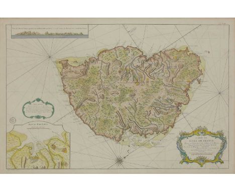
Lot 903
Map of Mauritius, 'Carte de l'Isle de France'by P A Rameau, 1763, hand-coloured,57 x 87.5cmThe island was originally colonised by France who named the island 'Isle de France'. It was seized by the British during the Napoleonic wars when it reverted to its original Dutch name, derived from Maurice, Prince of Orange. The dodo was already extinct by this time.Condition report: Central fold.
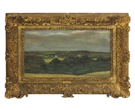
Lot 695
John Constable RA (1776-1837)Dedham Vale with Brantham mill and haystacks, c.1809-10oil on millboard26.8 x 43.3cm, in a gilt carved wood frameThe present view is looking south over Dedham Vale with the Church and sprawling village, and the far snaking line of the Stour against the southern higher ground.Provenance: Probably a member of the Constable family;Leggatt Brothers, London; Agnews (11510), sold 1946 to Major A.W. Allen (stock number 9159);and by descent to the vendorVerso: old label indistinctly inscribed ‘Landscape & ...’This previously unrecorded early oil sketch by John Constable is an exciting new discovery, and forms a useful new addition to the Constable literature. The fact that the picture once passed through the hands of Leggatt Brothers points towards a likely provenance direct from a member of the Constable family.During the first half of his career, when visiting the family home at East Bergholt during the summer and often sketching from nature there, Constable would tend to focus on two key landscape subjects: panoramic views overlooking the Stour valley, most especially vistas of Dedham Vale; or more enclosed views made in and around the mill at Flatford belonging to his father, Golding Constable.Constable’s paintings of Dedham Vale are usually taken from two favourite viewpoints: either (as is the case with this sketch) from the Suffolk side of the valley looking westwards across the Vale; or, as painted by him from as early as 1802, from the Essex side of the valley, from higher ground on Gun Hill, looking eastwards.The most famous representation by Constable of the former composition is the panorama of Dedham Vale, seen from the East Bergholt to Flatford Lane, which he sent to the Royal Academy in 1811 with the title 'Dedham Vale, Morning' (Proby Collection, Elton Hall; see Graham Reynolds, 'The Early Paintings and Drawings of John Constable', 1996, Yale University Press, no. 11.02). Constable made a number of preparatory oil sketches for this composition, which - like the final picture itself - show the towers of various Suffolk or Essex churches in the distance, of Stratford St Mary, Langham and Dedham (see Reynolds op.cit, R.11. 04-06). In these related sketches, Constable indicates the distant church towers with simple little white flecks of paint. This is his personal shorthand for showing their position in the landscape as well, no doubt, as to show the way they catch the light depending on the time of day and position of the sun.This previously unrecorded oil sketch shows the unmistakable tall tower of Dedham Church (and its adjacent village) in the far right hand distance. As Constable’s viewpoint here is clearly further east than the one he adopted for 'Dedham Vale: Morning', 1811, the two church towers of Stratford St Mary and Langham are no longer visible in the distance (they are out of sight on the right). Instead a windmill - apparently a weatherboarded post mill - has now come into view in the left hand middle distance. Like the towers of the local churches, Constable has rendered this mill in prominent strokes of white paint.By examining an ordnance survey map dating from the early nineteenth century, one can deduce that the windmill Constable shows here is likely to be identifiable as one situated at Brantham (see Ordnance Survey Map Sheet 64, Colchester; facsimile version of 1838 re-engraved map, on four quarter plates, based on 1805 single sheet impression of map). In fact Brantham boasted two mills in Constable’s day, both situated - a little to the south-west of Brantham village - on the river Stour where there was also a Lock - indeed Brantham Lock was the last of the 15 locks which, since the time of their construction in the eighteenth century, had rendered the River Stour navigable from Sudbury to Manningtree.Of the two windmills at Brantham, one was a wind driven postmill with sails - tentatively identified as the one Constable has painted here - and the other a tidal mill driven by water. As Ian Fleming-Williams pointed out, this was a convenient arrangement, as it meant that one could be used when the other was unable to work ('Constable and his Drawings', 1990, p.111). Both mills at Brantham are shown, sited very close to each other, in a tiny pencil sketch Constable made in 1814 ( Reynolds, op.cit, 14.23, albeit only the roof of the tidal mill is visible in this sketch). The mill shown in Constable’s oil sketch meanwhile is, as indicated above, likely to be identifiable from its sails as the wind driven post mill at Brantham (the tidal mill presumably being out of sight). Constable had made a more detailed drawing of this mill, in pencil and stump, as early as 1802 in which he showed its exact position on the river, and where the structure of the mill building can be made out in more detail ('The Windmill at Brantham', Victoria & Albert Museum, see Reynolds, op. cit, 02.8). He made a further sketch of the windmill at Brantham in the intact 1814 sketchbook in the Victoria & Albert Museum ( Reynolds, op.cit, 14.32, p.47).Windmills frequently caught Constable’s attention as potential subject matter for his art given his father’s profession as a corn (and coal) merchant. Not only did Golding Constable own mills at Flatford and Dedham, but he seems also to have owned the windmill at Brantham, and certainly had a coal-yard at the latter location (Fleming-Williams, op.cit, p. 112). The area around Brantham, then, would have been familiar territory for Constable during the first half of his career, and perhaps especially in the period 1805-8 when the young artist was involved in painting an altarpiece for the church at Brantham ('Christ Blessing the Children', 1805-8, on loan to Emmanuel College, Cambridge, Reynolds 05.2).Constable’s oil sketch of 'Dedham Vale with Brantham Mill' is painted on millboard, a support Constable is known to have taken up for oil sketching in the period around 1809, perhaps influenced by the adoption of the same support for sketching by his patron and mentor, Sir George Beaumont. Constable’s use of millboard here, together with the stylistic handling – strong tonal contrasts and a fairly even application of paint - point towards a date of c.1809-10. A view of 'Malvern Hall from the South-West' of 1809 in the Bristol Museums and Art Gallery (see right in catalogue), although executed on paper laid on canvas, is very similar in handling.I am especially grateful to John Somerville who kindly pointed out to me that the viewpoint is probably the furthest East that Constable ever painted Dedham Vale, and therefore that the mill is most likely to be that at Brantham owned by his father, Golding Constable.Anne LylesWe are grateful to Anne Lyles for her assistance in the cataloguing of this lot.Condition report: Oil on board. The board is fragile and brittle; the edges are very friable. Old tears in the support are visible at the top and bottom edges. There is a sketch on the reverse of the board with remnants of old paper tape around the edges. The oil painting on the front of the board is in a stable condition. There are losses associated with the tears and localised damages. There are scattered retouchings across the surface of the painting which are matte and are slightly mismatched to the original. The retouchings cover areas of damage and spots of wear and abrasion. In the sky the retouching gives the painting a slightly mottled appearance. The varnish is clear and glossy. The frame is in a good condition with a few scattered losses to the gilding on the sides. The painting is poorly secured in the frame with bent nails and cork spacers.

Lot 902
The Americas,Abraham Ortelius (1527-1598), 'Americae Sive Novi Orbis Nova Destriptio', a later pressing, copper map, hand-coloured,35 x 49cmThis map was first published in Antwerp the year before the Spanish Armada, as Francis Drake was 'singeing the King of Spain's beard' by sacking Cadiz.Condition report: No obvious major faults.Recently re-framed.

Lot 901
Frederick W Rose,'Angling in Troubled Waters - A Serio-Comic map of Europe',(repeated in French, German and Italian)...15 thousand, 1899, a coloured chromolithographic map, published by G W Bacon,54 x 73cmCondition report: See images.Creased along fold lines with loss of printed surface at the point of the fold and two small tears. Good strong colours, but framed with a back board, so no images of the reverse are available.Some very slight staining above the fishing rod in the Bay of Biscay.


Lot 1508
Utagawa Sadahide JAPAN (1807-1873) 26 x 38 cm Farbholzschnitt, ôban-Triptychon mit dem Titel: Yokohama Honchô narabi Miyozaki-chô saiken zenzu (Detaillierte Gesamtansicht von Honchô und Miyozaki-chô), signiert Gountei Sadahide, Verlag: Yamamoto Heikichi, Zensur- und Datumsiegel aratame, 1855-60. Dazu: Landkarte von Yokohama mit dem Titel Go Kaiko Yokohama no zu. Provenienz: Aus einer württembergischen Privatsammlung, zwischen den 1950er Jahren und 2000 gesammelt - Mehrfach gefaltet Utagawa Sadahide, Japan (1807-1873), an Ôban size colour woodblock triptych, titled Yokohama Honchô narabi Miyozaki-chô saiken zenzu (Detailed total view of Honchô and Miyozaki-chô), signed Gountei Sadahide, publisher: Yamamoto Heikichi, censor and date seal aratame 1855-60.In addition: a map of Yokohama with title Go Kaiko Yokohama no zu - Property from a Wuerttemberg private collection, assembled between the 1950s and 2000 - Folded

-
109182 item(s)/page