We found 109198 price guide item(s) matching your search
There are 109198 lots that match your search criteria. Subscribe now to get instant access to the full price guide service.
Click here to subscribe- List
- Grid
-
109198 item(s)/page


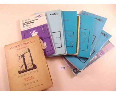

Lot 605
H. JALLIOT, TWO 17TH CENTURY FRENCH COLOURED ENGRAVINGS Map of Orleans, by H. Jalliot, 1696, inscribed in a Rococo style cartouche 'Gouvetnment D'Orleans et la Generalite devisee en ses elections par Le St Sanson Geographer Ord Du Roy A Paris chez H Jalliot aux Deum globes Alec privilege du Roy', together with a map of Nantes inscribed in a Rococo stake cartouche 'Carte de L'Evesche de Nantes dediee A Monseigneur Le Duc De Bourgogne', framed and glazed.
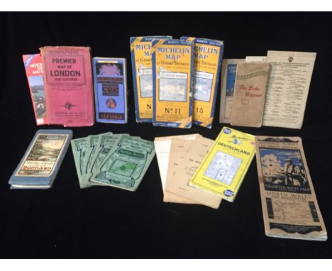
Lot 633
A SELECTION OF 1920'S AND LATER ROAD AND MOTOR TOURING MAPS To include W&AK JOHNSTON'S Motoring and Touring Map of Scotland, The Graded Road Maps, The Lake District and 'Bartholomews Revised Half-Inch Contoured Maps', sold together with two posters from Kent Motor Club Hill Climb, at the Devils Kneading Trough.


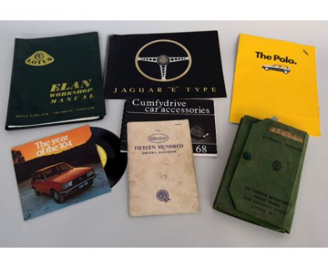
Lot 358
Automobile interest: A Lotus Elan Workshop Maual; a Jaguar "E" Type 1960s Sale Brochure together with a Jaguar Cars Ltd Apreil 1963 Price List of all models; a 1986 brochure for VW Polo; Peugeot 104 "The Year of the 104" 7" promotional vinyl record; a 1960s vintage AA pack, driving licenses and Motoring and Hiking Map;a 1937 International Driving Permit; Motor Fuel Ration Book; The Wolseley Fifteen Hundred Driver's Handbook (Fourth edition) and a 1968 "Cumfydrive car accessories" promotional handbook


![A 17th century map of 'Coventre' [sic] including two prospect views and a ground plan, a Robert Morden map of Cheshire c.1695](https://cdn.globalauctionplatform.com/1242238c-f718-4a88-a1a4-a74500e5b3d7/408d4955-6565-4471-e834-19705a3e9e2f/468x382.jpg)


Lot 2386
**AMENDED DESCRIPTION** An 18th century hand coloured engraving 'An East View of Dolwyddelan Castle in the county of Caernarvon', published 1742, a similar image 'The South East View of Cumner Abby [sic] in the County of Merioneth', published 1742 and three similar engravings of Welsh topographical subjects and a small double sided 18th century map of the road from Welshpool to Caernarvon and Dolgellau to Harlech, all framed and glazed (6).

Lot 754
A Picturesque Tour of the English Lakes, illustrated with forty-eight coloured views by Fielding and Walton, published for R Ackerman of London in 1821, appears complete but binding is damaged and pages are loose, some dog eared, also Blackie's Imperial Atlas of Modern Geography, published by Blackie & Son in 1860, containing maps of Britain and the world, appears complete, faux leather boarded cover separate from spine and ordnance survey maps of the Lake District, Castle Douglas, and Kirkcudbright and an AA 1/4" motoring map of Dumfries and Stranraer (5). CONDITION REPORT: A Picturesque Tour of the English Lakes: in poor condition with detached boards, staining and foxing throughout, no spine. Imperial Atlas: poor condition with detached boards, foxing and discolouration throughout. Three maps are in poor condition.
![[TOPOGRAPHY]. BRITISH TRAVEL Mogg, Edward. Paterson's Roads; being an entirely original and accurate description of all the](https://cdn.globalauctionplatform.com/15054e45-5697-4412-a62b-a73e0096c25e/96ff3b55-483f-472f-ac35-945a9352742c/468x382.jpg)
Lot 342
[TOPOGRAPHY]. BRITISH TRAVEL Mogg, Edward. Paterson's Roads; being an entirely original and accurate description of all the direct and principal cross roads in England and Wales, eighteenth edition, for Longman et al., London, 1826, half calf, folding map frontispiece, a further eleven maps / plates (as called for), small quarto.
![[MAPS] Forty-nine Ordnance Survey folding maps, comprising thirty-eight Landranger, six Explorer and five Outdoor Leisure se](https://cdn.globalauctionplatform.com/15054e45-5697-4412-a62b-a73e0096c25e/31f7e711-0fb6-482c-c938-f7d0e6749d21/468x382.jpg)


Lot 3197
Railway Related Framed Items including Great Western Railway map, LNER Train Service Leeds, Selby & Hull Oct 43 to Apr 44, Report of 'The Terrible Railway Catastrophe near Doncaster', Print: Travelling on the Liverpool and Manchester Railway, Mersey Tunnel Toll tickets (1936/37); Aire and Calder Navigation paper Trespass Notice and a few unframed items
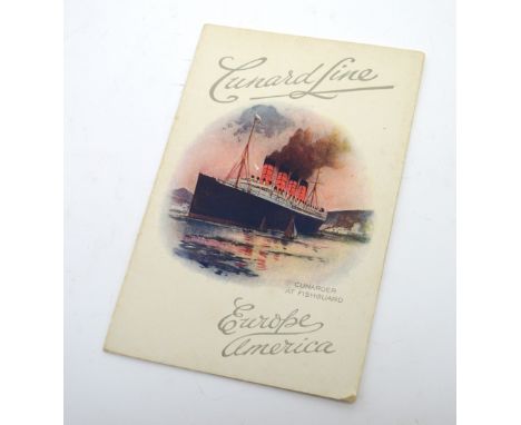
Lot 592
An original RMS Lusitania list of First Class saloon passengers from New York to Liverpool via Fishguard 9th October 1912, twenty page booklet with fold-out map containing the new Cunard Line Express Route, approx 7.5 x 5cm, this was handed down to the vendor by his grandfather who was a Superintendent Engineer for Cunard 1912-1918.


Lot 710
Risco (Manuel). La Castilla y el mas famoso Castellano. Discurso sobre el sitio, nombre, extension, gobierno y condado de la antigua Castilla. Historia del celebre Castellano Rodrigo Diaz, llamado vulgarmente el Cid Campeador, Madrid, 1792, signature to title, contemporary marbled sheep, gilt decorated spine with red morocco title label, 4to, together with Lopez de Ubeda, Francisco pseud. [i.e. Andrew Perez.], Libro de Entretenimineto, de la Picara Justina, en el qval debaxo de graciosos discursos, se encierran prouechosos auisos..., 3rd edition, Brussels, 1608, lacking frontispiece, some dust-soiling, browning and staining, contemporary vellum, small area of wear to spine, 8vo, with Armstrong (John), The History of the Island of Minorca, 2nd edition, 1756, engraved folding map frontispiece with closed tear to some folds (dampstained), four folding engraved plates, slight spotting, contemporary mottled calf, joints cracked and wear to extremities, 8vo, plus eight other antiquarian & modern Minorca & Spanish related etc. (11)
![[Brome, James]. An Historical Account of Mr. Rogers's Three Years Travels over England and Wales..., 1st edition, printed and](https://cdn.globalauctionplatform.com/6f06c57b-9702-4210-a2e3-a7400109952d/9fce7c81-2ed1-41da-9aa2-df501a3a24f0/468x382.jpg)
Lot 74
[Brome, James]. An Historical Account of Mr. Rogers's Three Years Travels over England and Wales..., 1st edition, printed and sold by J. Moxon and B. Beardwell, 1694, folding engraved map at front, entitled 'A New Mapp of England & Wales' (with two short closed handling tears), title with early ink ownership inscriptions, first four leaves with light water stain to fore-margins, last few printed leaves toned, second preliminary leaf with a little loss to upper blank corner, early 19th century calf, extremities rubbed and some light staining, small 8vo ESTC R39940; Wing B4857. A scarce copy of the unauthorized edition. James Brome published his authorized copy in 1700 under the title 'Travels over England, Scotland and Wales'. (1)

Lot 77
Burlington (Charles, and others). The Modern Universal British Traveller; or a New, Complete and Accurate Tour through England, Wales, Scotland and the Neighbouring Islands, Comprising all that is Worthy of Observation in Great Britain..., 1779, decorative allegorical frontispiece, two black & white engraved folding maps (without 'Map of Great Britain' as listed but with 'A Correct Map of Scotland from New Surveys' not called for), one with marginal fraying, the other with a few closed tears to folds, 106 engraved topographical views and historical scenes, without 'Porchester Castle in Hampshire' but with two not called for: 'The City Gates' and 'The Inside of the Royal Exchange London', one plate with crude later hand-colouring, closed tears, and some offsetting from plates, first few leaves near detached, four blank leaves inserted between pp. 546-547, further blanks at front and rear, front pastedown with bookplate of the Royal Institution of Charted Surveyors' Library, near contemporary reverse calf, marked, joints split and extremities worn, folio (1)

Lot 80
Camden (William). Britannia sive Florentissimorum Regnorum Angliae, Scotiae, Hiberniae et Insularum adiacentium ex intima antiquitate Chorographica descriptio..., published George Bishop & John Norton, 1607, additional decorative title with map of Great Britian trimmed to neatline and laid on second front free endpaper, eight engraved plates of coins, fifty-seven (complete) uncoloured engraved maps by William Kip and William Hole after Norden and Saxton, fifty five double-page and two single page (Rutland and Anglesey), small hole to upper margin of the map of Scotland, just touching the neatline, map of Berkshire with five watercolour heraldic shields and a Latin manuscript note to margins, index bound at rear, upper joint cracked, near contemporary calf, with an 18th century reback, worn and a little frayed at extremities, folio The sixth Latin edition but the first to contain maps. Chubb XVIII. (1)
Lot 83
Cary (John). Cary's Traveller's Companion or a Delineation of the Turnpike Roads of Scotland and Wales shewing the immediate Route to every Market and Borough Town throughout the Kingdom laid down from the best Authorities on a new set of County Maps..., 1814, calligaphic title with slight offsetting, advertisement and contents list, forty-three (complete as list) engraved maps with contemporary outline colouring, including one folding (Yorkshire), some offsetting throughout, map of Yorkshire with short closed tear, index and publisher's advertisement bound at rear, front endpapers detached, near contemporary ownership signature to front pastedown, contemporary half calf, upper board detached, lacking spine, heavily worn and frayed, 8vo Sold as a collection of maps, not subject to return. (1)
Lot 85
Cary (John). Cary's New Itinerary or an Accurate Delineation of the Great Roads, both Direct and Cross throughout England and Wales..., 6th edition, 1815, printed title and dedication, engraved folding map of England & Wales with repaired closed tears and splits along old folds and six further uncoloured folding engraved regional maps, bookplate of Richard Davies, later endpapers, modern half calf with contrasting morocco label to spine, 8vo, with another copy similar but lacking maps, together with Cary's New Map of England and Wales with part of Scotland..., 1794, lacking title page (facsimile loosely inserted), general map of England & Wales and seventy-seven double page engraved maps with contemporary outline colouring, later endpapers, modern half calf gilt with contrasting morocco labels to spine, 8vo, with Paterson (Daniel), A New and Accurate Description of all the Direct and Principal Cross Roads in England and Wales..., 11th edition, published T. N. Longman, 1796, frontispiece of an engraved map of England & Wales, title and dedication, index bound at rear, later marbled endpapers, modern green calf gilt, 8vo, plus Bartholomew (John), Philip's Handy Atlas of the Counties of England, published George Philip & Son, 1873, title with cancelled ownership signature, forty double page lithographic maps, publisher's advertisements for endpapers, contemporary cloth gilt, spine faded, 8vo (5)
Lot 87
Collinson (Rev. John). The History and Antiquities of the County of Somerset, collected from Authentick Records, and an Actual Survey made by the late Mr Edmund Rack..., 3 volumes, Bath: Printed by R. Cruttwell, 1791, engraved folding map frontispiece to volume 1 (torn along gutter and folds without loss, partially strengthened with linen and paper on verso), forty engraved plates and 1 vignette (correct as list), occasional spotting mostly to margins, book ticket of John Rutter to front pastedown and bookplate of Richard Mervyn Edmund Reeves to front free endpaper, marbled endpapers with repaired hinges, contemporary speckled calf, rebacked and corners repaired, 4to (3)
![Conybeare (William Daniel & Phillips, William ). Outlines of the Geology of England and Wales..., Part I [all published], 1st](https://cdn.globalauctionplatform.com/6f06c57b-9702-4210-a2e3-a7400109952d/e5f2cd30-374d-4db3-eea6-1de3ccfdc798/468x382.jpg)
Lot 88
Conybeare (William Daniel & Phillips, William ). Outlines of the Geology of England and Wales..., Part I [all published], 1st edition, 1822, folding hand-coloured map frontispiece and multi-folding hand-coloured plate of sections at rear, folding engraved plate of instruments with description leaf and folding table, a few diagrams to text, scattered minor spotting, contemporary ownership signature of James Simpson to title upper margin, contemporary half calf over marbled boards, rebacked with original spine relaid, slightly rubbed, 8vo (1)
Lot 89
Cooke (George Alexander). Topographical and Statistical Description of the County of York..., circa 1803, four engraved folding maps with contemporary hand colouring, one map (Yorkshire) with long repaired closed tear, later endpapers, contemporary tree calf, rebacked, 8vo, together with another edition from circa 1824, with Gent (Thomas), The Antient and Modern History of the famous City of York..., published Thomas Hammond, 1730, title page with manuscript date annotation, two uncoloured folding engraved frontispieces of a map of the city of York and a view of York, occasional red ink marginalia, bookplate of Eileen Green, later endpapers, 20th century half calf gilt, 8vo, plus Black (Adam & Charles, publishers), Black's Picturesque Guide to Yorkshire, 1st edition, published Edinburgh, 1858, frontispiece of a folding engraved map, fore-edge a little frayed, several illustrations to text and throughout, publisher's advertisment bound at rear, upper hinge and joints weak and cracked, contemporary cloth gilt frayed at head and foot of spine, small 8vo, with four later editions similar, and Bevan (G.Phillips), Tourists's Guide to the West Riding of Yorkshire, published Edward Stanford, 1877, additional half title, folding map, ink ownership stamp to front pastedown, upper hinge cracked, publisher's cloth gilt, worn and rubbed, small 8vo, with another six Bevan guides to the West and the North & East Ridings, various editions and condition, with White (Walter), A Month in Yorkshire, 4th edition, published Chapman and Hall, 1861, additional half title, folding engraved map by S. Hall bound at rear, publisher's cloth gilt, cloth faded, chipped at head and foot of spine, 8vo, with another four guide books, all 19th century, including examples by Pinnock, Tait, Bevan and Murray, all 8vo, various condition (20)
Lot 99
Gale (Roger, ed.). Registrum Honoris de Richmond Exhibens Terrarum & Villarum Qu‘ quondam fuerunt Edwini Comitis infra Richmundshire Descriptionem: Ex Libro Domesday in Thesauria Domini Regis..., 1st edition, published R. Gosling, 1722, vignette title-page printed in red & black (some spotting), list of subscribers, double page genealogical table, folding engraved map, fourteen engraved plates, some folding/double-page, letterpress engravings, text partly printed in black and red, engraved tail-pieces, slight spotting, pastedowns repaired, endpapers creased, contemporary mottled calf, crude repair to upper siding, re-backed, bumped and worn, folio Boyne CCXLIX. (1)


Lot 1
Atkinson (Thomas Witlam). Oriental and Western Siberia: A Narrative of Seven Years' Explorations and Adventures in Siberia, Mongolia, the Kirghis Steppes, Chinese Tartary, and Part of Central Asia, 1st edition, 1858, 4 chromolithographed and 16 tinted lithographed plates, folding linen-backed map, some illustrations to text, occasional spotting or browning, all edges gilt, contemporary green half morocco gilt, rubbed, large 8vo (1)
Lot 10
Carrascosa (Michele). M‚moires Historiques, Politiques et Militaires, sur la R‚volution du Royaume de Naples, en 1820 et 1821, et sur les causes qui l'ont amen‚e; accompagn‚s de piŠces justificatives, la plupart in‚dites, 1st edition, Treuttel et al, 1823, half-title present, folding map frontispiece (with short handling tear repaired with paper on verso), text lightly toned and a few spots, a few leaves with small water-stain to lower edge, patterned endpapers, front pastedown with gilt armorial bookplate of Archibald Philip, Earl of Rosebery, early 20th century half vellum, gilt decorated spine with gilt lettered red morocco label, 8vo Scarce. We have been unable to trace another copy at auction. Three locations only on COPAC (British Library, National Library of Scotland, Aberdeen University). (1)
Lot 110
Lewis (Samuel). A Topographical Dictionary of Ireland comprising the several Counties, Cities, Boroughs, Corporate, Market and Post Towns, Parishes and Villages..., 2 volumes together with the atlas volume, 1837, front endpaper of volume 1 with large manuscript ownership signature, title page and B1 of volume 2 with later biro ownership signature, some spotting, near contemporary cloth, volume 1 with broken hinges and lacking spine, volume 2 rebacked but retaining original spine, atlas volume with decorative calligraphic title page and contents list, folding general map of Ireland and thirty-two (complete as list) uncoloured engraved county maps, occasional marginal finger and dust soiling, text block detached, near contemporary cloth, soiled and stained Sold as a collection of maps, not subject to return. (3)
Lot 111
Lewis (William, publisher). Lewis's New Traveller's Guide and Panorama of England and Wales containing forty-four superior maps..., 1836, forty-four uncoloured engraved maps (complete) including a folding map of Yorkshire, light dampstaining throughout, original green cloth with publisher's printed paper label to upper cover, rubbed and marked with upper board and first few leaves near-detached, 8vo, together with Carington Bowles (publisher),Bowles's Post-Chaise Companion; or Travellers Directory through England and Wales..., volume 2 (only of two), 2nd edition, published 1782, printed title, 100 uncoloured engraved strip road maps printed on fifty sheets, list of fairs bound at rear, contemporary sheep, worn and frayed, 8vo, with Bartholomew (J.), Pocket Atlas of England & Wales, published John Walker & Co., 1887, printed, title, contents and tables, sixteen (complete as list) colour lithographic double page maps, hinges cracked, publisher's decorative blue cloth gilt, spine faded, small 8vo, plus Bacon (G. W. & Co. Ltd., publishers), Bacon's Road Atlas of England & Wales in three parts, North Section (only), circa 1925 twenty-four double page colour lithographic maps, some soiling and spotting to verso of upper cover, limp printed blue cloth wrappers, creased and soiled, 8vo, and Ordnance Survey (publishers), Ordnance Survey Atlas of England & Wales, Quarter Inch to the Mile, published Southampton, 1922, errata slip bound in before title, title page with library stamps, twenty-four double page photolithographic colour maps, each laid on linen, index bound at rear, ink library annotations to front pastedown, front endpaper and title page, hinges and joints weak, publisher's red cloth gilt, faded, worn and frayed, oblong folio, with Pinnock (W., editor), The Guide to Knowledge, volume 1 (only), 1833, title page and first first three pages torn with loss to margins and text, crudely repaired with tape, numerous wood engraved vignettes and maps to text throughout, fifty-three 'white on black' wood engraved maps of British counties, town plans. foreign countries, world and celestial charts, one plan torn with loss, contemporary cloth, rebacked, 4to Sold as a collection of maps, not subject to return. (6)
Lot 117
Morton (John). The Natural History of Northampton-Shire; with some Account of the Antquities. To which is Annex'd a Transcript of Doomsday-Book, so far as it relates to that County, 1st edition, 1712, large folding engraved map by John Harris (a little toned with short closed marginal tears), 14 engraved plates, lacking pages 177-180, Transcript and Index leaves misbound at front, a few minor spots, bookplate, contemporary panelled calf, rebacked, some edge wear, folio (1)
Lot 124
Phillips (John). Memoirs of William Smith, LL.D, Author of the "Map of the Strata of England and Wales", 1st edition, 1844, 5 engraved or lithographed portraits including frontispiece, 8 pp. advertisements at end, Imperial College Geology Library ink stamp to front pastedown and frontispiece recto, also small printed press mark label, original cloth, rebacked with original spine relaid and rear free endpaper renewed, rubbed and a little wear, white ink classification number at foot of spine, 8vo 500 copies printed. (1)
Lot 125
Phillips (John). Illustrations of the Geology of Yorkshire; or, A Description of the Strata and Organic Remains: accompanied by a geological map, sections, and plates of the fossil plants and animals, 2 volumes, 2nd edition, published John Murray, 1835 - 1836, single-page hand-coloured engraved geological map, 9 sectional plates, including 7 hand-coloured, thirty-seven uncoloured lithographed plates of fossil specimens and two folding plates of strata, some light spotting to fossil plates, contemporary half calf gilt, worn at extremities, cloth boards a little stained and marked, 4to, together with Bird (Charles), A Short Sketch of the Geology of Yorkshire, published Simpkin, Marshall & Co, 1881, additional half title, wood engraved frontispiece, folding colour geological map, very occasional spotting, publisher's decorative cloth gilt, 8vo, with Fox-Strangways (C.), Memoirs of the Geological Survey of the United Kingdom. The Jurassic Rocks of Britain, volume 1 (only), Yorkshire, 1892, frontispiece folding colour lithograhic map, numerous illustrations and folding plans and cross sections throughout, publisher's cloth gilt, 4to, plus Miall (L. C.), The Geology Natural History and Pre-Historic Antiquities of Craven in Yorkshire, published Joseph Dodgson, Leeds, 1878, title page and front endpapers with old library stamps, one colour lithographic geological map and one geological cross section, front endpaper abraided where an old ownership signature has been erased, hinges and joints weak, upper board near detached, publisher's cloth gilt, worn and rubbed at extremites, spine partially lacking, slim 4to (5)
Lot 126
Plot (Robert). The Natural History of Stafford-Shire, 1st edition, Oxford, 1686, title with engraved vignette of Pallas Athena in front of the Sheldonian, folding engraved map (loose with small splits, frayed fore-margins and repairs to verso), 37 engraved plates, including 26 double page or folding, subscribers list at end, lacking the 'Armes Omitted' plate plate V with outer corner torn away, one or two others close-trimmed, title verso with small repair at foot, a few minor spots, facsimile bookplate of Sir Isaac Newton, later calf, spine with black label and gilt decoration, a little rubbed with small abrasion to lower cover, folio Upcott 1172-1174; Wing P2588. (1)
Lot 130
Skelton (Joseph). Engraved Illustrations of the Principal Antiquities of Oxfordshire, from Original Drawings by F. Mackenzie, 1823, engraved frontispiece, title, map and 49 plates on india paper, some light spotting, hinges reinforced, all edges gilt, contemporary calf, oval arms of George James Welbore, Lord Dover gilt-stamped to covers, rebacked and repaired, a little scuffed, 4to Large paper copy. (1)
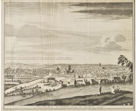
Lot 133
Thoresby (Ralph). Ducatus Leodiensis: Or, the Topography of the Ancient and Populous Town and Parish of Leedes, and Parts Adjacent in the West-Riding of the County of York, 1715, engraved portrait frontispiece, engraved folding map by Sutton Nicholls, eleven engraved plates and maps (including six folding), some light browning and scattered spots, later endpapers, 20th century brown full morocco, slightly rubbed, folio (1)

Lot 136
Walker (J. & C.). Hobson's Fox-Hunting Atlas containing separate maps of every County in England and the three Ridings of Yorkshire, published J. and C. Walker, circa 1870, title page with some finger and dust soiling and one small hole, forty-two (complete) double page lithographic maps with contemporary out line colouring, map of Wiltshire with contemporary manuscript annotations to upper margin and to verso of map, slight dust soiling, contemporary half morocco with gilt title to upper board, upper board detached, worn and a little frayed, folio (1)
-
109198 item(s)/page