We found 109182 price guide item(s) matching your search
There are 109182 lots that match your search criteria. Subscribe now to get instant access to the full price guide service.
Click here to subscribe- List
- Grid
-
109182 item(s)/page
![* Belgium. Ortelius (Abraham), Leodiensis Dioecesis Typus, [1595 or later], engraved map with contemporary hand colouring, el](https://cdn.globalauctionplatform.com/773a2f63-986c-4cc6-9db3-ad1200b50a92/aadf8396-f40d-401c-bdf0-ad1301259a82/468x382.jpg)

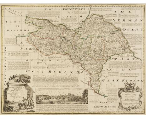
![Blaeu (Johannes).Cumbria vulgo Cumberland, Episcopatus Dunelmensis vulgo The Bishoprike of Durham [and] Westmoria comitatus A](https://cdn.globalauctionplatform.com/773a2f63-986c-4cc6-9db3-ad1200b50a92/70f5265a-4b1d-4c8f-a6ac-ad1301259b22/468x382.jpg)
Lot 453
Blaeu (Johannes).Cumbria vulgo Cumberland, Episcopatus Dunelmensis vulgo The Bishoprike of Durham [and] Westmoria comitatus Anglice Westmorland, Amsterdam, circa 1648, together three engraved maps with contemporary hand colouring, slight marginal staining to the map of Durham, but not affecting image, Westmorland with some marginal staining just affecting image, one small hole affecting image, each approximately 385 x 500 mm, French text on versoQty: (3)
Lot 454
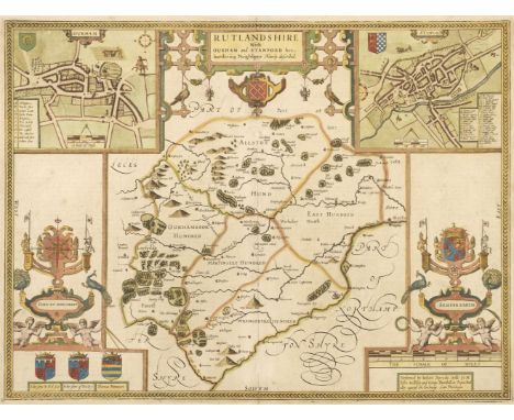
British county maps. A mixed collection of 19 maps, 17th - 19th century, including Bowen (Emanuel). An Accurate Map of the North Riding of Yorkshire Divided into its Wapontakes..., [and] An Accurate Map of the County of Bedford Divided into its Hundreds..., John & Carington Bowles, Robert Sayer and Robert Wilkinson, circa 1765, 2 engraved maps with contemporary outline colouring, originally published in Bowen & Kitchin's 'Large English Atlas', each with a large uncoloured allegorical cartouche, slight creasing and marginal staining, occasional repaired marginal closed tears, each approximately 540 x 690 mm, together with Speed (John). Rutlandshire with Oukham and Stanford her bordering Neighbour Newly described, 1st edition [1611], uncoloured engraved map, inset town plans of Oakham and Stamford, large strapwork cartouche, toned overall, central fold partially split at the base, some crude old repairs to margins, closed tears on the lower border, 380 x 510 mm, English text on verso, with Blaeu (Johannes). Westmoria comitatus Anglice Westmorland [and] Montgomeria comitatus et comitatus Mervinia, Amsterdam, circa 1650, two engraved map with contemporary hand colouring, slight spotting and marginal staining, each approximately 385 x 500 mm, Latin text on verso, plus Schenk (Pieter & Valk Gerard). Nortfolcia vernacule Norfolke, Amsterdam, circa 1710, engraved reticulated map with contemporary hand-colouring, some thinning to central fold, strengthened on verso, 375 x 475 mm, and another 13 engraved county and regional maps and maps of England & Wales, including examples by Morden (large format), Cary, Kitchin, Blair and De Vaugondy, various sizes and conditionQty: (19)
Lot 455
British County Maps. Five engraved maps, 17th & 18th century, including Kitchin (Thomas). A New Improved Map of Hampshire from the best surveys & Intelligence, Divided into Hundreds..., R. Sayer. T. Bowles and John Bowles & Son, circa 1764, engraved map with contemporary outline colouring, large uncoloured allegorical cartouche, old folds, some creasing, central fold repaired on verso, right-hand margin repaired and extended, some repairs to verso, the whole backed with archival tissue, 520 x 670 mm, with another copy similar, together with Blaeu (Johannes). Bercheria vernacule Barkshire, Amsterdam, circa 1650, engraved map with contemporary hand colouring, extensive repaired closed tears to margins and extending into the printed image, some 'bleeding' of the red watercolour, old watercolour has oxidised causing splitting to the printed image, repaired on verso, slight spotting, 380 x 500 mm, French text on verso, plus Drayton (Michael). Untitled map of Middlesex and Hertfordshire, circa 1612, uncoloured engraved allegorical map, torn with loss to the printed image in the lower corners, repaired and crudely replaced in facsimile, 250 x 330 mm, and Ogilby (John). The Roads from York to Whitby and Scarborough in Yorkshire [1676 or later], engraved strip road map, sheet 100 showing a surveyor using a waywiser in the cartouche, some later crude colouring to the cartouche, toned overall, some creasing and occasional fraying and repaired tears and small holes affecting the printed image, backed with tissue 330 x 445 mmQty: (5)NOTESSold not subject to return.
![British Isles. Ortelius (Abraham), Angliae, Scotiae et Hiberniae sive Britannicar: Insularum Descriptio [1592 - 1612], engrav](https://cdn.globalauctionplatform.com/773a2f63-986c-4cc6-9db3-ad1200b50a92/470db4c7-7bf2-4f04-800c-ad1301259eec/468x382.jpg)
Lot 458
British Isles. Ortelius (Abraham), Angliae, Scotiae et Hiberniae sive Britannicar: Insularum Descriptio [1592 - 1612], engraved map orientated to the west, contemporary outline colouring and some later enhancement, central fold strengthened and repaired on verso, backed with archival tissue, 345 x 500 mm, Latin text on versoQty: (1)NOTESMarcel van den Broecke. Ortelius Atlas Maps, no. 16.

Lot 460
Canada. Gill (MacDonald), Canada and Newfoundland. Their Natural and Industrial Resources, A. C. Ltd. 1942, pictorial colour lithographic map, old folds, one small marginal closed tear, torn with slight loss to the upper left corner, old drawing pin marks in each corner, 490 x 740 mmQty: (1)
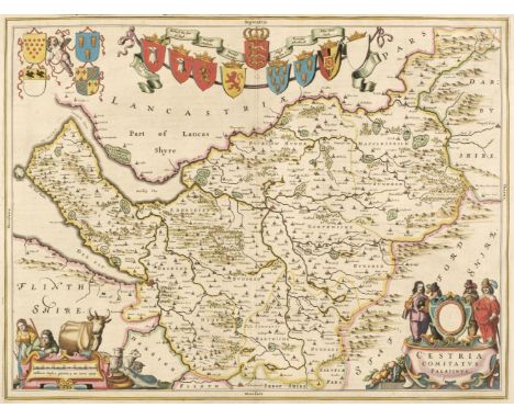
Lot 462
Cheshire. Blaeu (Johannes), Cestria comitatus Palatinus, Amsterdam, circa 1648, engraved map with contemporary outline colouring, decorative cartouche and mileage scale, 385 x 505 mm, Latin text on verso, mounted, together with Moule (Thomas). Cheshire, circa 1848, hand-coloured engraved map, slight overall toning, 200 x 260 mm, mounted, framed and glazedQty: (2)
![China. Jansson (Jan), China veteribus Sinarum Regnum nunc Incolis Tame Dicta, Amsterdam, l1640 or later], engraved map with c](https://cdn.globalauctionplatform.com/773a2f63-986c-4cc6-9db3-ad1200b50a92/38bae9a7-51e9-4733-8e17-ad130125a36c/468x382.jpg)
Lot 465
China. Jansson (Jan), China veteribus Sinarum Regnum nunc Incolis Tame Dicta, Amsterdam, l1640 or later], engraved map with contemporary outline colouring, decorative cartouche and mileage scale, toned overall, some oxidisation to old watercolour with slight cracking affecting the image, 410 x 495 mm, Latin text on versoQty: (1)NOTESThe map shows the eastern part of China, with the Great Wall in the north-west. The fictitious Chaimay Lacus is shown on the western border with numerous rivers flowing south into India and Siam. Korea is erroneously shown as an island and Japan is distorted and consists of only three islands. Taiwan is named as Pakan al I. Formosa. The map was one of the first to update Ortelius's map of 1584 and the revisions were largely based on more up to date Jesuit surveys.

Lot 466
China. Lotter (Tobias Conrad), Opulentissimum Sinarum Imperium juxta Recentissimam Delineationem in suas Provincias Disterminatum Cura et Sumtibus, Augsburg, circa 1760, engraved map with contemporary hand-colouring and some later enhancement, large allegorical cartouche, very slight staining to margins, 500 x 580 mmQty: (1)NOTESThe map shows China divided into provinces, with an allegorical title cartouche representing European trade with China. It was originally published around 1730 by Matthaus Seutter, but this example was published some thirty years later by Seutter's son-in-law & successor, Tobias Lotter.


Lot 470
England & Wales. Moll (Herman), The South part of Great Britain called England and Wales..., Philip Overton, circa 1715, engraved map with contemporary outline colouring on two conjoined sheets, large uncoloured allegorical cartouche, old folds, narrow margins, 610 x 980 mmQty: (1)NOTESR. W. Shirley. Printed Maps of the British Isles 1650 - 1750. Moll 6, state 2.

Lot 471
* Essex. Bickham (George), A Map of Hampshire. N. East view from London..., 1752, hand-coloured engraved aerial birds-eye view map, 260 x 155 mm, mounted, framed and glazedQty: (1)NOTESAn uncommon map, originally published in 'The British Monarchy or a Chrongraphical Description of all the Dominions Subject to the King of Great Britain' which was published in 25 parts between 1743 and 1754.

Lot 472
Essex. Speed (John & Norden John), Essex devided into Hundreds with the most antient and fayre towne Colchester described and other memorable monuments observed, George Humble, circa 1627, hand-coloured engraved map, an inset town plan of Colchester, central fold torn and crudely repaired on verso, 385 x 510 mm, English text on versoQty: (1)

Lot 473
Europe. De Wit (Frederick), Nova Europae Descriptio, Amsterdam, circa 1660, engraved carte-a-figures map with contemporary hand colouring and some later enhancement, eight costumed figures of European rulers to the vertical margins and six oval vignettes of principal cities along the upper horizontal margin, two additional vertical folds, folds strengthened and repaired on verso, 440 x 555 mmQty: (1)
![Europe. Hondius (Jodocus), Nova Europae Descriptio Auctore, Amsterdam [1619 - 28], hand-coloured engraved map, strapwork cart](https://cdn.globalauctionplatform.com/773a2f63-986c-4cc6-9db3-ad1200b50a92/8cf24c4a-7e7f-4d02-94c2-ad130125a8f4/468x382.jpg)

Lot 476
Fries (Lorenz). Untitled map of Poland, Transylvania, Hungary & Russia, Strasbourg, Michael Villanovus (Servetus), circa 1535, hand coloured woodblock map, large margins, 285 x 365 mm, ornate woodcut devices and Latin text on versoQty: (1)NOTESOriginally published in the 1535 edition of the 'Geographia'.
![* Hampshire & Berkshire. Valk (Gerard & Schenk Pieter), Hantoniae comitatus cum Bercheria, [1683 -1724], engraved map](https://cdn.globalauctionplatform.com/773a2f63-986c-4cc6-9db3-ad1200b50a92/8934f86a-8d2b-4d66-85fa-ad130125aad4/468x382.jpg)


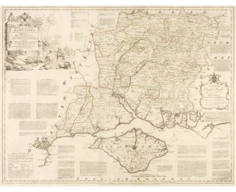
Lot 479
* Hampshire. Bickham (George), A Map of Hampshire. West from London..., 1750, hand-coloured aerial birds-eye view map, 260 x 155 mm, mounted, framed and glazedQty: (1)NOTESAn uncommon map, originally published in 'The British Monarchy or a Chronographical Description of all the Dominions Subject to the King of Great Britain' which was published in 25 parts between 1743 and 1754.


Lot 481
* Hampshire. Kitchin (Thomas), A New Improved Map of Hampshire from the best Surveys & Intelligences Divided into its Hundreds..., R. Sayer & Carington Bowles, circa 1767, engraved map with contemporary outline colouring and some later enhancement, large decorative coloured cartouche, 530 x 690 mm, mounted, framed and glazedQty: (1)
![* Hampshire. Luffman (John), Hampshire, [1803], engraved circular map with contemporary hand-colouring, English text below im](https://cdn.globalauctionplatform.com/773a2f63-986c-4cc6-9db3-ad1200b50a92/43e8b4d7-c349-4177-9ca9-ad130125ae11/468x382.jpg)
Lot 482
* Hampshire. Luffman (John), Hampshire, [1803], engraved circular map with contemporary hand-colouring, English text below image, slight overall toning, map diameter 60 mm, overall size 140 x 80 mm, mounted, framed and glazed, together with Ramble (Reuben). Hampshire [1845], uncoloured engraved map surrounded by topographical and historical lithographic vignettes with contemporary hand colouring, 190 x 150 mm, mounted, framed and glazed, with Van den Keere (Pieter). Southamtoniae, circa 1617, hand-coloured engraved map, 90 x 125 mm, mounted, with another later edition which is framed and glazed, plus Bowles (Carington). Bowles's Reduced Map of Hampshire, [[1785], uncoloured engraved map, 235 x 210 mm, and Badeslade (Thomas & Toms W. R.). A Map of Hampshire South West from London, 1741, engraved map with contemporary outline colouring, descriptive English text to left hand vertical margin, 155 x 155 mm, mounted, framed and glazedQty: (6)
Lot 483
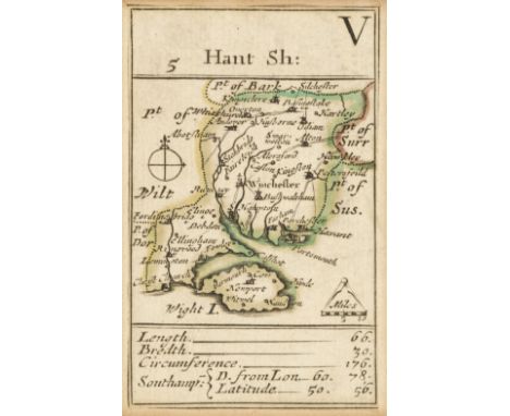
* Hampshire. Morden (Robert), Hant Sh: V, H. Turpin, circa 1750, engraved playing-card map with contemporary outline colouring, trimmed to printed neatline and tipped on to contemporary paper, 90 x 55 mm, mounted, framed and glazedQty: (1)NOTESThis later state of Morden's playing card maps lacks the suit markings. This was done possibly to discourage their use in gambling.
Lot 484
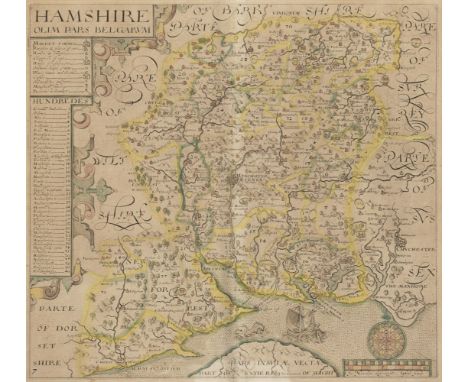
* Hampshire. Norden (J. & Hole G.), Hamshire olim pars Belgarum, circa 1637, hand-coloured engraved map, toned overall, 295 x 325 mm, mounted, framed and glazed, together with Greenwood (C. & J.). Map of the County of Southampton from an Actual Survey made in the years 1825 & 1826..., 4th July 1829, engraved map with contemporary outline colouring, calligraphic cartouche, compass rose, table of explanation, list of the Hundreds and an uncoloured vignette of Winchester Cathedral, 585 x 700 mm, mounted, framed and glazed, with Cary (John). A New Map of Hampshire Divided into Hundreds, Exhibiting its Roads, Rivers, Parks &c. Sept. 28th 1801, engraved map with contemporary hand colouring, 550 x 485 mm, mounted, framed and glazed, plus Moll (Herman). Hamp Shire, [1724 or later], uncoloured engraved map decorated with antiquities in the vertical margins, slight overall toning, 195 x 315 mm, mounted, framed and glazed, and three other maps of Hampshire by Cary & Moule, various sizes and conditionQty: (7)
Lot 486
* Hampshire. Saxton (Christopher), Southhamtoniae comitatus (preter Insulas Vectis Jersey et Garnsey quae sunt partes eiusdem comitatus) cum suis undigs consinibus Oppidis pagis Villis et Fluminibus vera descriptio, circa 1579, engraved map with contemporary hand colouring and some later enhancement, large strapwork cartouche and mileage scale surmounted by the royal crest of Elizabeth I, with the additional coat of arms of Thomas Seckford, engraved by Leonardus Terwoort, two repaired closed tears just affecting the image in the lower margin, 400 x 440 mm, mounted, framed and glazedQty: (1)NOTESThe first printed map of Hampshire

Lot 487
* Hampshire. Speed (John), Hantshire described and devided, John Sudbury & George Humble, circa 1627, hand-coloured engraved map, an inset town plan of Winchester, good margins, one small watercolour blemish, 375 x 505 mm, mounted, framed and double glazed, English text on versoQty: (1)NOTESA bright and clean example in very good condition.

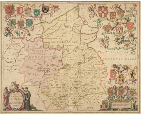
Lot 489
* Huntingdonshire. Speed (John), Huntingdon both Shire and Shire Towne with the Ancient Citie Ely Described, Thomas Bassett & Richard Chiswell [1676], hand-coloured engraved map, inset town plans of Huntingdon and Ely, 385 x 510 mm, mounted, framed and double-glazed, English text on versoQty: (1)
Lot 490
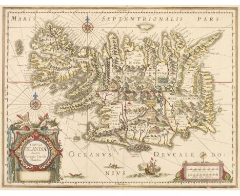
Iceland. Jansson (Jan), Tabula Islandiae Auctore Georgio Carolo Flandro, circa 1650, engraved map with contemporary hand-colouring, large decorative cartouche and mileage scale, compass rose and numerous rhumb lines, central fold partially split and repaired on verso, 380 x 500 mm, French text on versoQty: (1)


Lot 494
* Lithuania. Seutter (Matthaus), Novissima et Accuratissima Magni Ducatus Lithuaniae in suos Palatinatus et Castellanias Divisae Delineatio, Augsburg, circa 1720, engraved map with bright contemporary hand colouring, mounted with another slightly later (circa 1740) edition, in the third state with the J. M. Probst imprint in the upper left corner, each 495 x 570 mm, framed and glazedQty: (1)

Lot 501
London. Strype (John), A New Plan of the City of London, Westminster and Southwark, circa 1720, uncoloured engraved map, large decorative cartouche supported by Apollo and Athena, two additional cartouches, one of the arms of the City of London and one with a dedication to Sir George Thorold (Lord Mayor of London 1719 - 20), old folds, narrow margins, slight staining, 495 x 670 mmQty: (1)NOTESJames Howgego. Printed Maps of London, no.66.

Lot 502
London. Weller (Edward), Civitas Londinum Ano. Dni. circiter MDLX, London in the Reign of Queen Elizabeth, a facsimile (reduced) of the map by Aggas 1566, published Weekly Dispatch, circa 1865, uncoloured engraved panoramic map of London on two sheets, slight finger soiling to margins, overall size if conjoined 465 x 1250 mmQty: (2)
![Mexico. Mercator (Gerard), Hispaniae Novae Nova Descriptio, [1606 or later], engraved map with contemporary hand-colouring, l](https://cdn.globalauctionplatform.com/773a2f63-986c-4cc6-9db3-ad1200b50a92/a50323b0-b10d-4368-bbc2-ad130125be6a/468x382.jpg)

Lot 509
National Geographic Magazine (publishers). The Reaches of New York City, published Baltimore, 1939, large decorative folding lithographic map by Albert H. Bumstead, inset map of South Jersey, the margins decorated with portraits of prominent Americans, topographical vignettes and vistas, old folds, 705 x 645 mm, together with Southwestern United States, published Washington D.C. 1948, large decorative folding lithographic map, old folds, 560 x 840 mm, with The United States of America, Washington D. C. 1951, large folding lithographic map, inset maps of New York Area and East of Maine, old folds, slight fraying along folds, 650 x 1020 mm, with another copy similar, with The North Western United States, The North Central United States, The South Central United States [and] The South Eastern United States, circa 1950, together four lithographic maps, old folds each approximately 645 x 675 mm, plus The South Western United States, Washington D. D. 1940, large decorative lithographic map, the margins decorated with sixteen circular vignettes of topographical views and the seals of the relavent states on the map, with another four maps similar from the same series, various sizes and conditionQty: (13)

Lot 511
North America. Jansson (Jan), Virginiae partis Australis et Floridae partis Orientalis, interjacentiumq3 regionum nova descriptio, circa 1641, engraved map with contemporary outline colouring, central fold strengthened on verso, the printed surface showing signs of consolidation in the form of a paste wash, 385 x 505 mm, French text on versoQty: (1)NOTESPhilip Burden. The Mapping of North America, no. 254 state 1. The map extends from the southern part of Virginia to northern Florida and is virtually identical to Bleau's map of 1638. The map depicts the English and French colonial interests in the region illustrated by their respective Royal coat of arms and several new colonies are noted. At the southern end of the Appalachians, there is a note about gold and silver mines.

Lot 512
* Northern Europe. Ruscelli (Girolamo). Europae Tabula VIII, circa 1562, wood-engraved map with contemporary hand colouring on a trapezoidal projection, mounted with a slightly later uncoloured version, each approximately 190 x 255 mm, framed and glazed, together with Munster (Sebastian). Slesiae Descriptio XV Nova Tabula, circa 1552, uncoloured woodcut map, 295 x 370 mm, mounted, framed and glazed, with La Table du Pays de Pomeran selon les principautez..., circa 1560, uncoloured woodcut map, 9 heraldic shields above map, French text below and on verso of map, 255 x 385 mm, mounted, framed and glazed, plus Solinus (Caius Julius). Europa, circa 1538, uncoloured woodcut map, some later pen annotations, 145 x 230 mm, mounted in a triple-aperture mount with two smaller versions of the map, each approximately 65 x 100 mm, framed and glazed, with another two 16th-century maps of Northern Europe by Sebastian Munster, good condition, various sizes, framed and glazedQty: (6)
![Ogilby (John). The Road from London to Chichester in com Sussex [and] The Road from Chester to Cardiff com Glamorgan, [1675 o](https://cdn.globalauctionplatform.com/773a2f63-986c-4cc6-9db3-ad1200b50a92/9afcfd77-ea92-4da9-b06d-ad130125c3c0/468x382.jpg)
Lot 514
Ogilby (John). The Road from London to Chichester in com Sussex [and] The Road from Chester to Cardiff com Glamorgan, [1675 or later], two hand-coloured engraved strip road maps, each approximately 320 x 435 mmQty: (2)NOTESThe first map (sheet 39) commences at Guildford and runs through Godalming, Chiddingfold, Midhurst and ends at Chichester, with a continuation from Midhurst through Petersfield, ending at Winchester. The second map commences at Chester and runs through Wrexham and ends at Lampeter.

Lot 518
* Poland. De Vaugondy (Robert), Le Royaume de Pologne..., 1767, engraved map with contemporary outline colouring and some later enhancement to the strapwork cartouche, mounted with another later example from circa 1796 showing the partition between Russia, Prussia and Austria, each 485 x 540 mm, framed and glazed, together with Mentelle (Edme & Chanlaire Pierre-Gilles). Carte de L'Ancien Royaume de Pologne partagé entre la Russie, La Prusse et L'Autriche, 1795, engraved map with contemporary outline colouring, mounted with another slightly later example form 1807 showing the additional partition to Germany, 435 x 625 mm, framed and glazedQty: (2)

Lot 519
* Poland. Du Val (Pierre), La Cours de L'Elbe et de L'Oder où sont Electorats de Saxe et de Brandebourg, Les Duchés de Mekelbourg et de Pomeranie, Paris, 1684, engraved map with contemporary hand colouring, presented in a double aperture mount with another slightly earlier example, each 405 x 530 mm, framed and glazed, together with Jansson (Jan). Ducatus Silesiae Grotagnus cum Districtu Episcopali Nissensi..., Amsterdam, circa 1650, engraved map with contemporary hand-colouring, slight creasing, presented in a double aperture mount with another slightly later example, each 400 x 505 mm, framed and glazedQty: (2)
Lot 520
Poland. Homann (J. B. heirs of), Polonia Propria tanquam Regni Polonici..., 1772, engraved map with contemporary hand-colouring, uncoloured strapwork cartouche and mileage scale, large margins, 420 x 490 mm, together with Rizzi Zannoni (Giovanni Antonio Bartolomeo). Carte Generale de la Pologne avec tous les Etats qui en dependent, Paris, circa 1780, engraved map with contemporary outline colouring, uncoloured decorative cartouche and mileage scale, 325 x 460 mm, with another copy similar, with Zatta (Antonio). La Pologne divisee en ses Palatinats selon la dernier condivision des Tris Puisances Sovoire L'Autriche, La Russie, La Prussw, Venice, 1802, engraved map with contemporary outline colouring, slight staining to central fold, short split at base of central fold, 500 x 655 mm, plus Gussefeld (Franz Ludwig). Charte von Polen nach den Bewährtesten Hültsmitteln dem Theilungs Tractat vom Jahr..., 1806, engraved map with contemporary outline colouring, some near-contemporary underlining of principal towns and cities, 485 x 525 mm, and another four unattributed maps of Poland, various sizes and conditionQty: (9)

Lot 521
* Poland. Jaillot (Alexis Hubert), Estats de la Couronne de Pologne, Presente a Monseigneur le Duc de Bourgogne, Paris, circa 1730, engraved map with contemporary outline colouring, several small repaired marginal closed tears along the bottom margin, additional title "Tabula Regni Poloniae ..." above map, 500 x 610 mm, mounted, framed and glazedQty: (1)
![Poland. Speed (John), A Newe Mape of Poland, Thomas Bassett & Richard Chiswell, [1676], hand-coloured engraved 'carte-a-f](https://cdn.globalauctionplatform.com/773a2f63-986c-4cc6-9db3-ad1200b50a92/f4313dd3-e906-4931-9f52-ad130125c947/468x382.jpg)
![Russia. Speed (John), A Map of Russia, Thomas Bassett & Richard Chiswell, [1676], hand-coloured map engraved by Francis L](https://cdn.globalauctionplatform.com/773a2f63-986c-4cc6-9db3-ad1200b50a92/82a43768-a202-4941-a657-ad130125c9de/468x382.jpg)
Lot 524
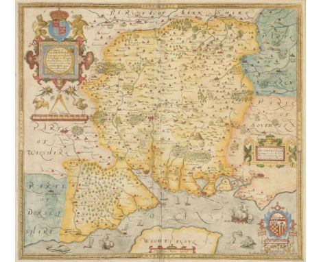
Rutland. Speed (John), Rutlandshire with Oukham and Stanford her bordering Neighbour Newely described, 1st edition, 1611, hand-coloured engraved map, inset town plans of Oakham and Stanford, large strapwork cartouche and mileage scale, 390 x 515 mm, English text on versoQty: (1)NOTESA bright clean example.


Lot 526
Scandinavia. Blaeu (Willem Janszoon), Suecia, Dania et Norvegia regna Europae Septentionalia..., Amsterdam circa 1640, engraved map with contemporary outline colouring, large decorative cartouche containing the coats of arms of the 3 nations, 435 x 535 mm, Lain text on versoQty: (1)NOTESA clearly defined map of the kingdoms of Sweden, Denmark and Norway. The legend in the title cartouche attributes the map to Anders Bure (1571-1646), a Swedish cartographer and mathematician. Bure is best known for his 6-sheet map of Scandinavia and for serving as the first director of the Swedish land survey. The Kingdom of Sweden appears a great deal larger than the boundaries of the nation today because it contains present-day Finland and the Baltic states.

![Scotland. Ortelius (Abraham), Scotiae Tabula, [1584], uncoloured engraved map orientated to the west, large strapwork cartouc](https://cdn.globalauctionplatform.com/773a2f63-986c-4cc6-9db3-ad1200b50a92/4f47aee2-36fb-4b20-a205-ad130125cd3b/468x382.jpg)
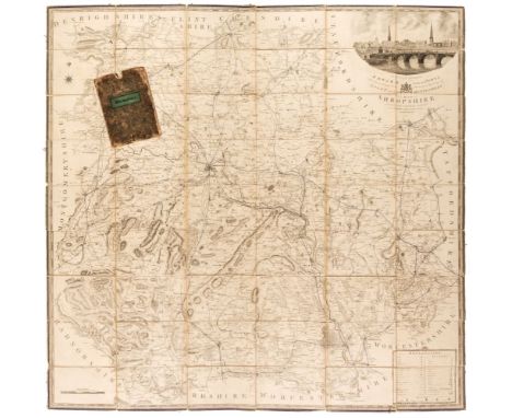
Lot 532
Shropshire. Baugh (Robert), To the Right Honourable Edward Earl of Powis Lors Lieutenant and Custos Rotulorum of the Counties of Salop and Montgomery, This Map of Shropshire is humble and respectfully dedicated by His Lordship's obliged and obedient Servant..., Robert Baugh, Llanymynech, Shropshire [1st August 1808], engraved large scale map, sectionalised and laid on linen, sparse later 19th-century outline colouring highlighting the railways, large calligraphic cartouche surmounted by a view of English Bridge in Shrewsbury, table of explanation and mileage scale, slight staining, edged with blue silk which is frayed in places, marbled endpapers, 1395 x 1420 mm, contained in a contemporary marbled slipcase with a printed label to the upper cover, slipcase worn and frayedQty: (1)NOTESThe first and only edition of this scarce map of Shropshire.

Lot 533
Silesia. Blaeu (Willem Janzoon). Silesia Ducatus A Martino Helwigio Nissence descriptus, Amsterdam, circa 1650, engraved map with contemporary outline colouring, large decorative cartouche, 385 x 500 mm, French text on verso, together with Lotter (Tobias Conrad). Nova Mappa Geographica Totius Ducatus Silesiae Tam Superioris quam Inferioris exhibens..., Augsburg, 1758, engraved map with contemporary outline colouring, an inset town plan of Breslau (Wroclaw), 480 x 570 mmQty: (2)

Lot 534
Silesia. Coronelli (Vicenzo Maria), Silesia Inferiore..., 1694, hand-coloured engraved map, very large ornate cartouche, 460 x 620 mm, together with Jansson (Jan). Silesiae Ducatus nova et accurata descriptio, Amsterdam, circa 1640, hand-coloured engraved map, several marginal closed tears, old folds, 385 x 500 mm, no text on verso, with Silesia Ducatus. circa 1700, a hand-coloured unattributed map, old folds, 365 x 470 mmQty: (3)
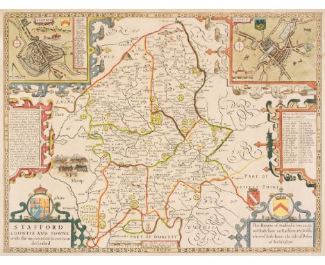
Lot 535
* Staffordshire. Speed (John), Stafford Countie and Towne with the ancient Citie Lichfield described, Thomas Bassett & Richard Chiswell, [1676], hand-coloured engraved map, inset town plans of Stafford and Lichfield, laid on later card, slight staining to margins, 390 x 515 mm, framed and glazed, together with Darbieshire Described, 1st edition, John Sudbury & George Humble, [1611], uncoloured engraved map, inset town plan of Derby and a view of Buxton Well, several long closed tears affecting image, they and the central fold crudely repaired on the recto with old tape which has browned and stained the printed surface, light overall toning, narrow margins, 385 x 510 mm, mounted, framed and glazed, English text on verso, with Leicester both Countye and Citie described, The Honorable Famylies that have had the titles of Earls thereof. With other accidents therein observed, John Sudbury & George Humble, circa 1627, uncoloured engraved map, an inset town plan of Leicester, central fold toned, closed tear affecting image, some creasing, lightly toned overall, 375 x 505 mm, mounted, framed and glazedQty: (3)
![Tartary. Speed (John), A Newe Mape of Tartary, Thomas Bassett & Richard Chiswell [1676], hand-coloured engraved carte-a-f](https://cdn.globalauctionplatform.com/773a2f63-986c-4cc6-9db3-ad1200b50a92/53e878d9-415a-4d3b-82e4-ad130125d1e7/468x382.jpg)
Lot 537
Tartary. Speed (John), A Newe Mape of Tartary, Thomas Bassett & Richard Chiswell [1676], hand-coloured engraved carte-a-figure map, 4 oval vignettes of principal cities to upper margin and 8 costumed figures to the vertical margins, large strapwork cartouche, two small wormholes affecting image, central fold strengthened on verso, 395 x 515 mm, English text on versoQty: (1)
![Van Langeren (Jacob). A collection of 36 maps, originally published in 'A Direction for the English Traveller...,' [1643], un](https://cdn.globalauctionplatform.com/773a2f63-986c-4cc6-9db3-ad1200b50a92/33f49505-d233-45cc-8dd3-ad130125d281/468x382.jpg)
Lot 538
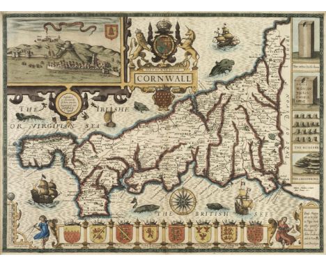
Van Langeren (Jacob). A collection of 36 maps, originally published in 'A Direction for the English Traveller...,' [1643], uncoloured engraved miniature maps, set into the lower right corner below a triangular mileage table, slight spotting, the map of Hampshire with marginal water staining, a contemporary ink manuscript title on the verso causing slight show through, each approximately 105 x 105 mm, apart from the map of Wales which measures 230 x 210, together with the title page and directions for using the mapsQty: (36)NOTESThe maps comprise:- Wales, Lancashire, Hampshire, Dorset, Gloucestershire, Devon, Middlesex, Cheshire, Suffolk, Somerset, Essex, Oxford, Sussex, Cornwall, Berkshire, Warwickshire, Worcestershire, Buckinghamshire, Lincolnshire, Herefordshire, Westmorland, Huntingdon, Cumberland, Cambridge, Durham, Derbyshire, Staffordshire, Nottinghamshire, Wiltshire, Hertfordshire, Leicestershire, Shropshire, Northamptonshire, Bedfordshire, Northumberland and Norfolk.

![Wales. Ortelius (Abraham & Lhuyd Humphrey), Cambriae Typus Auctore Humfredo Lhuydo Denbigiense Cambrobritano [1608- 12],](https://cdn.globalauctionplatform.com/773a2f63-986c-4cc6-9db3-ad1200b50a92/01a8a889-57a8-4596-b4c2-ad130125d3dc/468x382.jpg)
Lot 540
Wales. Ortelius (Abraham & Lhuyd Humphrey), Cambriae Typus Auctore Humfredo Lhuydo Denbigiense Cambrobritano [1608- 12], hand-coloured engraved map, large strapwork cartouche, central fold strengthened and repaired on verso, slight creasing to the margins, 375 x 505 mm, Italian text on versoQty: (1)NOTESMarcel van den Broecke. Ortelius Atlas Maps, no 21 state 2. John Booth. Antique Maps of Wales, map no.2
-
109182 item(s)/page