We found 109198 price guide item(s) matching your search
There are 109198 lots that match your search criteria. Subscribe now to get instant access to the full price guide service.
Click here to subscribe- List
- Grid
-
109198 item(s)/page


Lot 15
STAMPS : SOUTH ATLANTIC, a fine mostly mint collection of Falkland Islands, Falkland Dependencies & British Antarctic Territory. Useful mint sets inc Dependencies thick & thin 1946 Map sets & used thin set. Falklands 1935 Jubilee mint & used sets, used 1938 GVI set to 10/-, 1952 set mint, 1968 set mint etc. British Antarctic 1963-69 set mint & 1971 set etc. A good, clean collection. STC £2,100+

Lot 5
Three books - Clutterbuck's History and Antiquities of the County of Hertford, being volumes I,II & III, with the map of the County and other original records and embellished with views and the most curious monuments of antiquity. Published in London, printed by and for Nichols, Son, and Bentley 1815, with tooled leather spines and bound in blue and black.


Lot 1440
A Collection of Old Maps to include Moors Appletwick and Nidderdale, Rathmell District, Leeds Geology, Burnsdale and Hebden, Dentdale, Bishopdale, Kendall, Helm Part of Rathmell Area, Map of area west of central Howgills, Storth area and Milnthorpe sands, Buchden, Leeds and District geographical survey, part of Morecambe Bay, South of Kendall Division, care rescue organiasation, Skipton division, Northern or Appleby division, Moorland view, Stockdale, Barden, Knaresborough and 1862


Lot 313
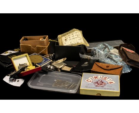
Collection of Ephemera including four packs of vintage cards, comprising playing cards, Lexicon, Whot and Canasta; a handmade wooden and metal cribbage score board; two vintage metal one hole hand punches; a Zenith paper drill; map measure made in West Germany; Masonic cuff links and a collection of medals; St John Ambulance medals and badges; round table studs; Blackpool Tower medallions; Blackpool Tower Pen Knife; Silver coloured leaf tie bar; W.I<. Centenary Brooch.

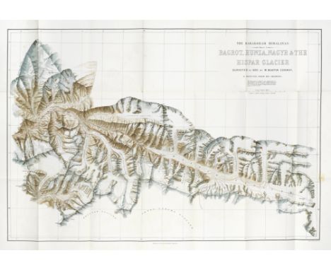
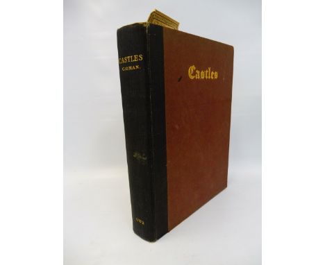
Lot 105
CONWAY (WILLIAM MARTIN)Climbing and Exploration in the Karakoram-Himalayas, 4 vol. (including 'Scientific Reports', and portfolio of maps), FIRST EDITION, ONE OF 150 DE LUXE COPIES SIGNED BY THE AUTHOR on the limitation page, this copy 'number 1' for the publisher, half-titles, photogravure portrait, 300 plates and illustrations by A.D. McCormick, the plates in 2 states (one printed on India paper mounted), with tissue title guards printed in gold), 3 folding maps (2 colour-printed, and one route map) loose in case as issued, original tan buckram, gilt morocco spine labels (one missing), soiled [Neate C103; Yakushi C143, erroneously calling for 5 maps], large 8vo, T. Fisher Unwin, 1894Footnotes:COMPLETE SET OF CONWAY'S CLASSIC ACCOUNT OF THE EXPLORATION OF THE HIMALAYAS. 'In 1892 Conway led a large-scale mountaineering expedition to the Karakoram Himalayas with the financial support of scientific societies and his father-in-law, Manton Marble... Conway's large party surveyed the Baltoro glacier and the region around K2, and ascended Pioneer Peak on Baltoro Kangri, which at 6890 metres may have constituted an altitude record at the time' (ODNB).Provenance: Thomas Fisher Unwin (1848-1935, publisher of Conway's book), bookplate; bequeathed 'to the Alpine Club... in memory of pleasant days on the mountains. Feb 6th 1935'. Unwin was himself a keen mountaineer once climbing the Matterhorn, and Conway served as president of the Club from 1902 to 1904; Alpine Club, small withdrawal stamp on verso of titles.This lot is subject to the following lot symbols: •• Zero rated for VAT, no VAT will be added to the Hammer Price or the Buyer's Premium.For further information on this lot please visit Bonhams.com
Lot 11
ANSON (GEORGE)A Voyage Round the World, in the Years MDCCXL, I, II, III, IV, FIRST EDITION, LARGE PAPER COPY, edited by Richard Walter, with p.319 misnumbered 219, 42 engraved plates, maps and plans (most folding), list of subscribers, 'Directions to the bookbinder' at end, one map with tear repaired, one shaved just touching image, occasional toning and light off-setting, contemporary speckled calf, neatly rebacked preserving original gilt-tooled spine with red gilt morocco spine [Hill 1817; Sabin 1626], 4to (285 x 225mm.), John and Paul Knapton, for the Author, 1748Footnotes:'A MASTERPIECE OF DESCRIPTIVE TRAVEL. Anson's voyage appears to have been the most popular book of maritime adventure of the eighteenth century' (Hill). The first official account of Anson's circumnavigation, edited from Anson's 'papers and materials' by Richard Walter, the Expedition's chaplain. 'The book was both a stirring story of adventures at sea and an exhortation to further Pacific enterprise' (Glyn Williams, The Prize of All the Oceans. The Triumphs and Tragedy of Anson's Voyage, 1999). This copy is considerably larger than the standard quarto first edition (see following lot).Provenance: Earl of Breadalbane, bookplate. This is most probably the third Earl, John Campbell (1696-1782); Stowe Library, bookplate.This lot is subject to the following lot symbols: •• Zero rated for VAT, no VAT will be added to the Hammer Price or the Buyer's Premium.For further information on this lot please visit Bonhams.com
Lot 12
ANSON (GEORGE)A Voyage Round the World, in the Years MDCCXL, I, II, III, IV, FIRST EDITION, ordinary paper issue, edited by Richard Walter, with p.319 misnumbered 219, 42 engraved plates, maps and plans (most folding), list of subscribers, 'Directions to the bookbinder' at end, one plate with short tear, one map with small repairs at folds with archival paper, contemporary calf, spine gilt, neatly restored at joints, later gilt morocco lettering label [Hill 1817; Sabin 1626], 4to (253 x 200mm.), John and Paul Knapton, for the Author, 1748Footnotes:Provenance: John Guy, early ownership inscription on leaf B1.This lot is subject to the following lot symbols: •• Zero rated for VAT, no VAT will be added to the Hammer Price or the Buyer's Premium.For further information on this lot please visit Bonhams.com
Lot 13
ANSON (GEORGE)A Voyage Round the World, in the Years MDCCXL, I, II, III, IV, fifth edition, edited by Richard Walter, folding engraved World map frontispiece, 42 engraved plates and maps (mostly folding, with some adhesion abrasions at fold), ALL HAND-COLOURED, untrimmed in modern half calf [Hill 1820, with plates hand-coloured], large 4to (310 x 240mm.), for the Author, by John and Paul Knapton, 1749Footnotes:A LARGE COPY, GENEROUSLY-MARGINED, WITH ALL THE PLATES HAND-COLOURED. This edition includes the chart 'shewing the track of the Centurion round the world' (including California as an island) which was not included in the first edition. The copy of this edition cited by Hill also has hand-coloured plates. Provenance: Donald H. Graham Jr., bookplate.This lot is subject to the following lot symbols: •• Zero rated for VAT, no VAT will be added to the Hammer Price or the Buyer's Premium.For further information on this lot please visit Bonhams.com
Lot 14
ANSON (GEORGE)A Voyage Round the World, in the Years MDCCXL, I, II, III, IV, bound in 2 vol. (text and plates), fifth edition, edited by Richard Walter, folding engraved World map frontispiece, 42 engraved plates and maps (mostly folding, occasional offsetting and light stains, plate 33 shaved within platemark of upper margin), contemporary calf, 2-line gilt fillet border on sides, rebacked with period style gilt-tooled spine, slightly rubbed [Hill 1820], 4to (text 255 x 202mm.; atlas 272 x 225mm.), for the Author, by John and Paul Knapton, 1749Footnotes:An unusual copy with the plates bound separately, probably for the library at Milton Hall, the largest private house in Cambridgeshire.Provenance: Earl Fitzwilliam, probably the 3rd Earl, bookplate; Milton Hall, Peterborough, the seat of the Fitzwilliam family, booklabel; Ida and F.W. Hosken, Africana book collectors, bookplate.This lot is subject to the following lot symbols: •• Zero rated for VAT, no VAT will be added to the Hammer Price or the Buyer's Premium.For further information on this lot please visit Bonhams.com
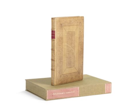
Lot 16
ANSON (GEORGE)A Voyage Round the World, in the Years MDCCXL, I, II, III, IV, twelfth edition, edited by Richard Walter, folding engraved World map frontispiece, 42 engraved plates and maps (mostly folding), bookplate of the Weslyan Library (withdrawn), contemporary calf, rebacked in calf retaining original spine label, folio (290 x 210mm.), T. Osborne, and others, 1767--BARROW (JOHN) The Life of George Lord Anson, FIRST EDITION, engraved frontispiece, publisher's cloth, spine faded, 8vo, John Murray, 1839--[MILLECHAMP (LAWRENCE)] A Narrative of Commodore Anson's Voyage into the Great South Sea and Round the World, NUMBER 1 OF 5 COPIES, first complete edition with reproductions of title, dedication and illustrations from the original manuscript, introduction by Colin Paul, panelled calf antique, red morocco spine label, solander box, 8vo, [Shaftesbury, Colin Paul, 1994]; and approximately 30 others relating to George Anson, H.M.S. Wager and related voyages, together with several original engravings, and research notes of Colin Paul (small quantity)Footnotes:Colin Paul's interest in the Anson narratives spanned a period of over fifty years, starting with the his purchase from Maggs in 1961 of Barrow's biography of Anson, and leading eventually to his publishing for the first time Lawrence Millechamp's contemporary account, the present lot including all five copies that were printed. Excerpts from the account had been published in 1967 by Glyndwr Williams, but here Colin Paul publishes the text in its entirety as well as Millechamp's charming watercolours (mostly ornithological) from the manuscript which is held by the National Maritime Museum. Signed copies of classic works by Williams and Rear Admiral C.H. Layman are also included.This lot is subject to the following lot symbols: •• Zero rated for VAT, no VAT will be added to the Hammer Price or the Buyer's Premium.For further information on this lot please visit Bonhams.com
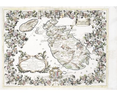
Lot 166
CORONELLI (VINCENZA MARIA)Isola di Malta, olim Melita... dedicata... all'illustrissimo, et eccellentissimo Signore Giorgio Corner, hand-coloured double-page engraved map, issue with blank verso and without the plate crack found in some others, the margins decorated with 62 engraved armorials of the Grand Masters of the Order of Saint John from 'Fra Gerardo' to Giorgio Caraffa, larger coat of arms of Giorgio Corner, title within large decorative strapwork cartouche, 8-line ink note in an early Italian hand about Jean de la Cassière (Grand Master of the Order of Malta 1572-1581) in the margin, and another note in sea area, wide margins (with a little worming neatly repaired), 460 x 610mm., Venice, 1689Footnotes:Coronelli's detailed and highly decorative map of Malta and Gozo, dedicated to Cardinal Giorgio Corner of Padua.This lot is subject to the following lot symbols: •• Zero rated for VAT, no VAT will be added to the Hammer Price or the Buyer's Premium.For further information on this lot please visit Bonhams.com
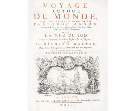
Lot 20
ANSON (GEORGE)Voyage autour du monde fait dans les années MDCCXL, I, III, IV... dans la Mer du Sud, half-title, title printed in red and black with engraved vignette, 34 engraved plates, maps and charts (mostly folding, 2 with short tear repaired), new front free endpaper, old ownership name inked over at foot of final leaf, contemporary cat's paw calf, spine tooled in gilt in compartments, Geneva, Barillot et fils, 1750; Derde durk van het echt verhaal der reistogt rondsom den aardkloot, ondernomen op order des konings van Groot-Britaine in den jare 1740 met een escader van zes oorlogscheepen onder 't bevel van den Commandeur George Anson, 3 parts in 1 vol., engraved portrait frontispiece of Anson, title printed in red and black, 5 folding engraved plates, one folding engraved map, contemporary calf gilt, joints slightly worn, 4to, Delft, Reinier Boitet, 1754, 4to (2)Footnotes:The first edition in French of the official account of Anson's expedition, together with the third Dutch edition, expanded to include for the first time Isaac Morris' account of the shipwreck of the Wager.This lot is subject to the following lot symbols: •• Zero rated for VAT, no VAT will be added to the Hammer Price or the Buyer's Premium.For further information on this lot please visit Bonhams.com
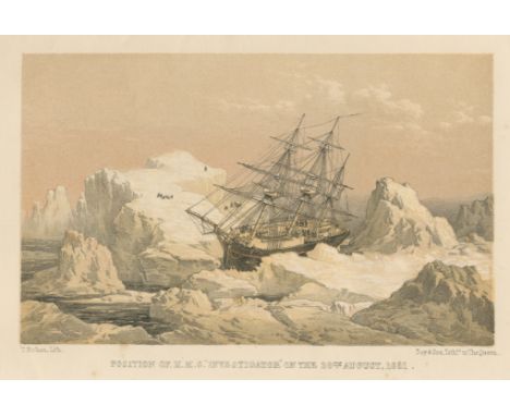
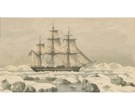
Lot 204
ARMSTRONG (ALEXANDER)A Personal Narrative of the Discovery of the North-West Passage with Numerous Incidents of Travel and Adventure During Nearly five Years' Continuous Service in the Arctic Regions while in Search of the Expedition under Sir John Franklin, FIRST EDITION, tinted lithographed frontispiece, folding route map (torn with some loss), publisher's blue pebble-grained cloth, yellow endpapers with binder's ticket at rear, extremities rubbed, hinges slightly weak [Hill 34; Sabin 2017], 8vo, Hurst & Blackett, 1857Footnotes:First hand account of Robert McClure's voyage in search of Franklin, by the surgeon and naturalist aboard the HMS Investigator. The ship was trapped in ice and abandoned in 1853, until the wreck was discovered by scientists in 2010.This lot is subject to the following lot symbols: •• Zero rated for VAT, no VAT will be added to the Hammer Price or the Buyer's Premium.For further information on this lot please visit Bonhams.com
Lot 206
FRANKLIN AND NORTH-WEST PASSAGECOLLINSON (RICHARD) Journal of H.M.S. Enterprise, on the Expedition in Search of Sir John Franklin's Ships by Behring Strait. 1850-55, FIRST EDITION, edited by T.R. Collinson, colour lithographed frontispiece, 6 folding maps, photogravure portrait, light spotting, early blue calf gilt, the sides with 3-line fillet border enclosing an image of two entwined flags ('Enterprise for Franklin'), t.e.g., rebacked preserving original spine with red gilt morocco lettering labels, Sampson, Low, 1889--M'CLURE (RICHARD) The Discovery of the North-West Passage by H.M.S. 'Investigator'... 1850, 1851, 1853, 1854, second edition, edited by Captain Sherard Osborn, half-title, engraved frontispiece, 4 lithographed plates, map supplied in facsimile), publisher's cloth, joints repaired, new endpapers, Longman, Brown, 1857, 8vo (2)Footnotes:Account of the Franklin Search expedition undertaken in 1849, led by Sir Richard Collinson in the H.M.S. Enterprise. 'Of the many who had searched for Franklin, Collinson came closest to the place where the expedition had ended. Collinson's addition to geographical knowledge on this Arctic trip was very considerable, and would have been tantamount to the discovery of the north-west passage, had this not been already actually achieved by the men of the Investigator' (ODNB), the second ship on the expedition, captained by Robert Maclure.This lot is subject to the following lot symbols: •• Zero rated for VAT, no VAT will be added to the Hammer Price or the Buyer's Premium.For further information on this lot please visit Bonhams.com

Lot 209
M'CLINTOCK (FRANCIS)The Voyage of the 'Fox' in the Arctic Seas. A Narrative of the Discovery of the Fate of Sir John Franklin and His Companions, FIRST EDITION, wood-engraved plates, 3 folding maps on 2 sheets (one in pocket at end), folding facsimile, publisher's blue cloth with gilt ship on upper cover, John Murray, 1859--PEARY (ROBERT E.) The North Pole, FIRST EDITION, plates, publisher's cloth with gilt medallion portrait on upper cover, Hodder & Stoughton, 1910--NANSEN (FRIDTJOF) 'Farthest North', 2 vol., folding map, plates and illustrations, publisher's pictorial cloth, George Newnes, 1898--DU CHAILLU (PAUL) The Land of the Midnight Sun, new edition, folding frontispiece, illustrations, publisher's pictorial cloth, George Newnes, 1899, 8vo; and 36 others on Arctic exploration (41)This lot is subject to the following lot symbols: •• Zero rated for VAT, no VAT will be added to the Hammer Price or the Buyer's Premium.For further information on this lot please visit Bonhams.com
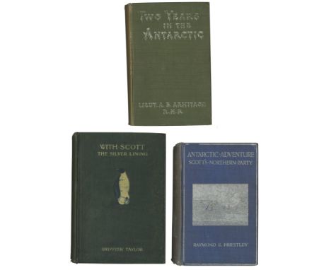
Lot 213
ARMITAGE (ALBERT B.)Two Years in the Antarctic. Being a Narrative of the British National Antarctic Expedition, 15 photographic plates, folding map (short tear at inner edge), numerous illustrations, publisher's catalogue at end, occasional foxing, last few leaves roughly opened, publisher's green cloth, variant without figure on upper cover, spine slightly faded [Rosove 17.A1.c; Taurus 43], Edward Arnold, 1905--PRIESTLEY (RAYMOND E.) Antarctic Adventure, 3 folding maps and numerous plates, 'presentation copy' blindstamp on title, ownership inscription of W. Harold Hundle, 1914, publisher's pictorial cloth blocked and lettered in silver, rubbed, spine faded [Rosove 256.A1a; Taurus 80], T. Fisher Unwin, 1914--TAYLOR (GRIFFITH) With Scott: the Silver Lining, first issue without author's preface, plates and maps (2 folding, one of which colour), some spotting, publisher's pictorial green cloth, slight staining to covers [Rosove 324.A1; Taurus 81], Smith, Elder, 1916--Scott's Last Expedition... Arranged by Leonard Huxley, numerous plates (some colour, some double-page), 8 folding maps, ownership signature of Edgar Lanham, 1913, publisher's blue cloth, lettered in gilt, t.e.g., spines slightly worn [Rosove 290; Taurus 77], Smith, Elder, 1913, FIRST EDITIONS, 8vo; and another (6)This lot is subject to the following lot symbols: •• Zero rated for VAT, no VAT will be added to the Hammer Price or the Buyer's Premium.For further information on this lot please visit Bonhams.com
Lot 221
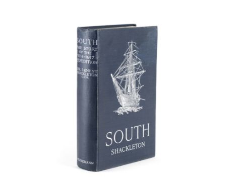
SHACKLETON (ERNEST HENRY)South. The Story of Shackleton's Last Expedition 1914-1917, FIRST EDITION, FIRST ISSUE, with errata slip, colour frontispiece, plates (mostly photographic by Frank Hurley), large folding map (short tear at inner margin), text slightly browned as usual, publisher's blue pictorial cloth gilt, silver lettering and upper cover image of 'Endurance', spine ends and corners slightly bumped, slight damp mark to upper cover [Spence, p.49; Taurus Collection 105], 8vo, William Heinemann, 1919This lot is subject to the following lot symbols: •• Zero rated for VAT, no VAT will be added to the Hammer Price or the Buyer's Premium.For further information on this lot please visit Bonhams.com
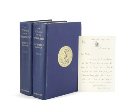
Lot 225
SCOTT (ROBERT FALCON)The Voyage of the 'Discovery', 2 vol., FIRST EDITION, with an AUTOGRAPH LETTER SIGNED by the publisher Reginald Smith (31 October 1905, headed 'I have given Captain Scott your note'), photogravure frontispieces, numerous maps and plates including 12 in colour after Edward Wilson, folding map in pocket at the end of each volume, publisher's slip tipped into volume 1, occasional light soiling, publisher's blue cloth with gilt medallions on sides, gilt lettered spines, t.e.g., [Conrad, p.121; Rosove 286; Spence 1051; Taurus 41], 8vo, Smith Elder & Co., 1905Footnotes:First edition of Scott's narrative, with a loosely inserted letter written in the month of publication by the book's publisher Reginald Smith to the political journalist and Polar devotee Henry William Lucy: 'Dear Mr. Lucy/ I am very glad to see that you like the Antarctic book so much. You have said, in 'Punch' and in 'Vanity Fair', in print and much more forcibly, what I have been telling Captain Scott for the last twelve months while he was writing his book. Now he is inclined to believe me!/ Yours faithfully/ Reginald Smith'. Henry Lucy had reviewed Scott's book in Punch six days earlier, ending 'Written in the simple literary form in which brave men naturally narrate their doings, no more glowing narrative of adventure is to be met with in the English language'. Lucy was also a friend of Shackleton and a major fund-raiser for his Polar ventures, in recognition of which the explorer named a mountain after him in Antarctica.This lot is subject to the following lot symbols: •• Zero rated for VAT, no VAT will be added to the Hammer Price or the Buyer's Premium.For further information on this lot please visit Bonhams.com

Lot 75
D'ANVILLE (JEAN BAPTISTE BOURGUIGNON D')Province de Quang-Tong, double-page engraved map, large pictorial cartouche, blank on verso, 440 x 545mm., [Paris, 1785]Footnotes:A decorative map of the provinces of Guandong (Canton) and Hainan, centred on the Macao and Hong Kong region.This lot is subject to the following lot symbols: •• Zero rated for VAT, no VAT will be added to the Hammer Price or the Buyer's Premium.For further information on this lot please visit Bonhams.com
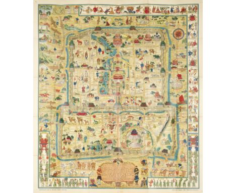
Lot 77
DORN (FRANK)A Map and History of Peiping. With Explanatory Booklet, FIRST EDITION, large folding colour lithographed map of Peking (865 x 755mm.), light overall toning, several short tears at folds, with 22pp. of text, the map loose as issued in pocket inside lower cover publisher's printed cloth-backed paper wrappers, original printed slipcase (torn with small loss at edges) [Pegg, Cartographic Traditions in East Asian Maps, pp.54-55], small 4to, Tientsin-Peiping, Peiyang Press, 1936Footnotes:THE FIRST EDITION OF A HIGHLY DECORATIVE MAP OF BEIJING, depicting the principal sites and occupations of the inhabitants of the city, within a pictographic border showing Chinese history, the whole enlivened with amusing vignettes of the everyday life and sights of the city.This lot is subject to the following lot symbols: •• Zero rated for VAT, no VAT will be added to the Hammer Price or the Buyer's Premium.For further information on this lot please visit Bonhams.com


Lot 106
A very large map of the Peninsula of India; from the 19th Degree of North Latitude to Cape Comorin. The Gants or Passes through the western chain of mountains to which they give their name, are distinguished by a double line. James Wyld, Geographer to the Queen, 11 & 12 Charing Cross, S.W. London, approx 83 x 100 cms (io), glazed and framed.

Lot 710
Local Interest - a mid-Victorian ink MS on vellum indenture, Counterpart Deed of Partition of the Friary Estate in Derby, Dated 8th day of July 1856, composed of five pages, signed and sealed in red wax, by various members of the Mozely family, 62cm x 71cm overall; another, earlier, Mortgage to secure £400 & with a Power of Sale, from Mr Jno Davy to The Revd Jno Pridham, Dated 20th April 1838, 57cm x 77cm; a George II ink MS on parchment identure, Attested Copy of Deed of Revocation and appointment [...] [between] Samuel Burton Esqr and Ann his Wife, Dated 16th March April 1745; 'estate' land map of Mickleover [5]


Lot 3336
An early 20th century children's didactic cartographic jigsaw, Superior Dissected Maps: England & Wales, the complete chromolithograph map printed on paper, cut and laid onto corresponding cut wood pieces, four-fold G.W. Bacon & Co., Ltd., map of England and Wales en suite, 31cm x 25.5cm, original box, sliding cover applied with advertising, 24.5cm wide, c. 1935


Lot 735
A collection of engraved 18th century maps by Robert Morden comprising a framed coloured example of Barkshire (sic) 36 x 43 cm approx. visible sheet size, a further unframed coloured map of Surrey 37.5 x 43 cm and two uncoloured framed maps comprising Barkshire 9 x 45 cm, and Northamptonshire 39 x 43.5 cm approx. (4)

Lot 768
Robert Morden (British c.1650-1703) - An engraved coloured map of Gloucestershire, 35 x 42cm approx. visible sheet size, together with a mid-19th century watercolour and bodycolour on paper, study of a landscape with church spire, indistinctly signed, inscribed with North Wales location and dated 64, 21 x 42cm, both framed


Lot 738
E H Whitfield (20th century) - Pair of ink and watercolour studies of water towers, both signed and dated 1959, 24 x 34cm, a coloured reproduction of Saxton's Map of Pembrokeshire, 1578, 35 x 47cm approx., a Christmas greeting after Percy Vignale from the 48th Division Christmas 1917, inscribed Somme, Peronne and Ypres, 16 x 25cm, etc, various sizes, mostly framed (11)
Lot 145
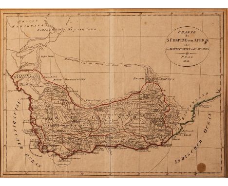
John Barrow CHARTE DER SÜDSPIZE VON AFRICA ODER DES HOTTENTOTTEN UND CAPLANDS Prague, 1811 Copperplate, hand coloured, 1,8cm wide white stripe along centerfold, 1,5cm oily spot in corner, light tanning across map with darker line along window frame edge, pencil note in margin; verso: map secured to window mount with masking tape at top and sides, paper strip along centerfold, original fold lines visible in lighter tone, foxing with heavier foxing and tanning in margins, ink and pencil notes on back and a circle in light ink, framed40 by 29cm
Lot 144
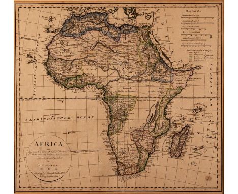
Johann Nepomuk Diewald & Christoph Fembo (ed) AFRICA Nuremberg, 1821 Copperplate, hand coloured, light foxing with a few darker spots, 1,5 cm oily spot in lower right corner, pencil note in margin, light toning with tanning behind window mount; verso: map secured to window mount with masking tape at top and part sides, two pencil numbers, paint show through, paper strip along centerfold, framed50,5 by 45,5cm
-
109198 item(s)/page