We found 109182 price guide item(s) matching your search
There are 109182 lots that match your search criteria. Subscribe now to get instant access to the full price guide service.
Click here to subscribe- List
- Grid
-
109182 item(s)/page


Lot 411
POPE (A), THE WORKS OF ALEXANDER POPE, nine vols, engraved frontis to vol I, full tan calf, London, A Millar, 1766; THE ILIAD OF HOMER, four vols, vol I with engraved frontis, two plates and folding map, vol IV with folding map, full tan calf, London, J Whiston, 1771; THE ODYSSEY OF HOMER, five vols, full tan calf, London, J Whiston, 1771 (18)

Lot 471
BIBLE (ENGLISH – 17TH CENTURY), THE HOLY BIBLE CONTAINING THE OLD TESTAMENT AND THE NEW, comprising, A CONCORDANCE TO THE BIBLE OF THE LAST TRANSLATION, title with engraved armorial, London, Assignes of Clement Cotton 1632; THE GENEALOGIES RECORDED IN THE SACRED SCRIPTURES, by J.S., with engraved plates and double page map engraved title page to the New Testament, imprinted at London by Robert Barker 1633 and engraved title to the New Testament; THE BOOK OF PSALMES COLLECTED INTO ENGLISH MEETER, BY Thomas Sternhold, John Hopkins and others, London imprinted for I.L., 1633; A FORM OF PRAYER TO BE USED IN PRIVATE HOUSES; full tan leather with tolled detailing (boards detached) (1).Additional InformationTitle of Concordance with loss to the outside edge but does not affect text or ruled lines. Page 1 / A2 of Genealogies with a tear close to the spine, P21 with small tear into text and the map with a small vertical tear at the bottom of the fold. Engraved title to Old Testament with small tear at top into top left square. A5 of Translators with small tear into text. A2 of Genesis with loss of paper along the bottom edge – this does not affect text. Third blank after A4 (A7?) with loss to bottom corner but does not affect text. Ff3 of The Book of Job with a tear into the first column of text. Kk4 second blank of Psalmes with small tear at top into text. Ll4 with a tear into the first column of text. Xx at Ezekiel with a small chip which just nudges into the margin notes. Fourth blank after Sss4 of Luke with a chip to the edge which does affect the red line but not the text. Ttt with a chip at the bottom and there is some loss of text here. Xxx3 and Xxx4 in John with a tear at the bottom which goes into the second from bottom line of text. Yyy with two small tears – one is just into the first line of text. The preceding page to this has a small tear which just touches the call word. Aaaa2 with a chip to the top corner which does affect the text in the chapter line. Title to the Book of Psalms with a tear at the top into the which goes into the third line of text and does have a small hole. Second blank after A4 (A6?) of the Book of Psalms with a small tear into the first line of text. D of Psalms with a tear coming in from the side edge into the column of text. Second blank after D4 (D6?) with a tear at the bottom which goes up into ten lines of text. Concordance title followed by *2 and finishes on the reverse of H2. Malachi ends reverse of Ccc4 (End of the Prophets) and is followed by title to the new testament. The call word APO on the reverse of Ccc4 is not on the title page which follows. Corners of pages rounded. Some page creasing. Other small chips, little tears and nicks to the page edges and general age browning throughout. Some old blemishes to the text here and there. the Bible is 23.5cm high x 18cm side and 7.5cm deep.
Lot 488
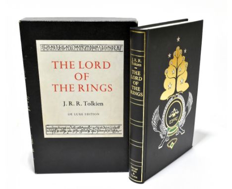
TOLKIEN (J.R.R), THE LORD OF THE RINGS, de-luxe edition, 3rd impression, pictorial black cover and two section box with paper label, George Allen and Unwin, 1974 (1).Additional InformationBox with some wear to edges of the top and to the corners of the base section, heaviest to one corner (see images). Binding with a few light marks. No previous owners name. Initial pages slightly undulated. Odd Fox spot to a page here and there. Some slight creasing to a few of the pages and p227 with a crease at the print stage which impinges on the text. Corners of Took the great smials and The longfather tree with fold over to bottom corner and this has occurred at binding because the fold over section is larger than the page size. Top left corner of folded map with slight tear and crease.


Lot 277
Abyssinia, Macpherson after Outhett, a map of Abyssinia and the adjacent districts laid down partly from original Observations taken in the Country and partly compiled from information collected there by Henry Salt Esq., part hand coloured, mounted, framed, glazed 75 x 92cm overall Provenance: with an applied printed label stating this came from the home of a former British Diplomat to Ethiopia.


Lot 46
Meinertzhagen (Richard). Birds of Arabia, 1st edition, London: Oliver and Boyd, 1954, colour plates, illustrations, folding map (loosely inserted), contemporary burgundy half morocco gilt, 4toQty: (1)NOTESPresentation copy, inscribed "John Barlee, from R. Meinertzhagen, February 1955". John Barlee was the author of Birds on the Wing (1947).
Lot 5
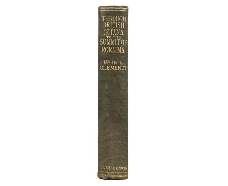
Clementi (Mrs Cecil). Through British Guiana to the summit of Roraima, 1st edition, London: T. Fisher Unwin, 1920, folding map, half-tone illustrations, advertisements, frontispiece detaching, offsetting to title, one or two closed marginal tears, a little light spotting, original cloth, spine and part of lower cover faded, 8voQty: (1)NOTESNeate C79. Cecil Clementi was appointed Colonial Secretary of British Guiana in 1913 and with his wife undertook a journey through the country to the highland region bordering Venezuela and Brazil in 1915-16.

Lot 53
White (Gilbert). The Natural History of Selborne, edited, with an introduction and notes by E.M. Nicholson, London: Thornton Butterworth, 1929, 16 mounted wood-engraved plates by Eric Daglish, folding map, extra wood-engraved plate "The Snipe", signed by the artist mounted at front, one or two leaves unopened, rear endpaper toned, original vellum-backed boards, a little rubbed, some soiling to vellum, 4to, limited edition 41/125, together with The Life and Letters of Gilbert White of Selborne, written and edited by Rashleigh Holt-White, 2 volumes, 1901Qty: (3)

![* Devon. Saxton (Christopher & Kip William), Devoniae comitatus vulgo Denshyre..., [1610], hand-coloured engraved map, or](https://cdn.globalauctionplatform.com/d3a06311-0b61-4c67-8749-ad7400bebae4/8152b384-1edf-412c-8317-ad7c00e5fba3/468x382.jpg)
Lot 57
* Devon. Saxton (Christopher & Kip William), Devoniae comitatus vulgo Denshyre..., [1610], hand-coloured engraved map, ornate strapwork cartouche and mileage scale, slight creasing, 295 x 335 mm, mounted, framed and glazed, together with Rapkin (John). Plymouth, Devonport and Stonehouse, circa 1850, hand-coloured engraved city plan, slight staining, 255 x 350 mm, mounted, framed and glazed, with Owen (Samuel & Bowen Emanuel). The Road from Nottingham to Lincoln and on the reverse, The Road to Grimsby, [1720 or later], hand-coloured engraved strip road map, 175 x 110 mm, mounted, framed and glazedQty: (3)

Lot 58
England & Wales. Cary (John), Cary's New Map of England and Wales with Part of Scotland, on which are carefully laid down all the Direct and Principal Cross Roads, the Course of the Rivers and the Navigable Canals, Cities, Market and Borough Towns, Parishes and most considerable Hamlets, Parks, Forests &c &c, 1st edition, 1794, dedication, printed title with slight staining, general map of England & Wales (frayed with slight loss), table of explanation and 76 (complete) engraved map sheets (numbered 1 - 81 and omitting 62/63, 71/72 & 80 as intended), all with contemporary outline colouring, each page laid on contemporary linen, slight fraying and loss to some map sheets, slight spotting and staining, contemporary limp morocco 'envelope style' binding, rubbed and worn at extremitiesQty: (1)NOTESA copy of Cary's multi-sheet map of England Wales adapted for travelling, with each map sheet backed with linen and gently rolled over to create a pocket-sized portable map.

Lot 59
England & Wales. De Vaugondy (Robert), Le Royaume D'Angleterre divisé selon les sept Royaumes ou Heptarchie de Saxons avec la Principauté de Galles; et subdivisé en Shires ou Comtés, Paris, 1753, engraved map with contemporary outline colouring, large uncoloured decorative cartouche, 485 x 525 mm, together with Kitchin (Thomas). An Accurate Map of Great Britain from the latest and best observations, circa 1770, uncoloured engraved map, old folds, 395 x 300 mm, with another hand-coloured copy with some repaired closed tears, with A New & Accurate Map of the Roads of England and Wales with the Distances by the Mile Stones..., circa 1770, uncoloured engraved map, old folds, some staining, 345 x 350 mm, plus Kitchin's most Accurate Map of the Roads of England and Wales..., circa 1763, engraved map with sparse outline colouring, old folds, some staining, long repaired marginal closed tear affecting image, 345 x 345 mm, and Wyld (James). Wyld's A Map of England, Wales & Scotland describing all the Principal Cross Roads in Great Britain..., circa 1840, engraved map with contemporary outline colouring, inset map of Scotland, slight dust soiling, old folds strengthened on verso, repaired marginal closed tears, 730 x 615 mm, together with Brion de la Tour (Louis). L'Angleterre divisée en 5 Grandes partis, subdivisées en 52 Comtes..., Paris 1766, engraved map with contemporary outline colouring, descriptive text (printed from separate sheets) pasted to vertical margins, central fold repaired on verso, 290 x 485 mm, and Weidner (I. G. L.). Charte der Vereinigten Konigreiche Gros Britanien und Ireland..., 1804, engraved map with contemporary outline colouring, three inset columns of descriptive text, some water staining, 595 x 484 mmQty: (8)


Lot 63
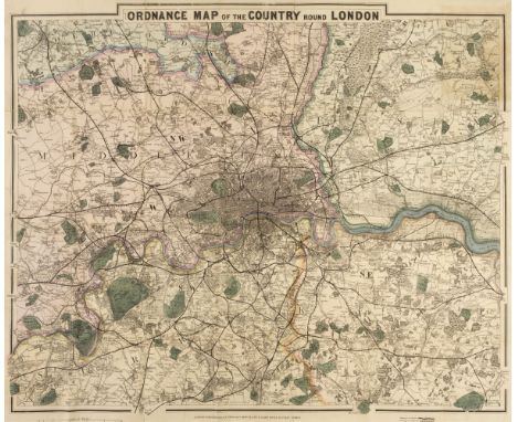
London. Cruchley (George Frederick). Ordnance Map of the Country round London, circa 1875, lithographic folding map with contemporary outline colouring, slight staining, laid on linen, 590 x 700 mm, contemporary green cloth boards with publisher's red and white label to upper cover, binding size 165 x 110 mmQty: (1)

Lot 65
Map Reference. A collection of approximately 130 books and periodicals, 20th century, reference books and periodicals including Mercator's World and The Map collectors Circle and books including examples by Wheat & Brun, Batten & Bennett, Chubb, Tooley, Hodson, Moreland & Bannister and Ristow, various sizes and conditionQty: (4 cartons)

Lot 66
Map Reference. The British Museum. Catalogue of Printed Maps Charts and Plans, Photolithographic edition, complete to 1964, 16 vols. (including the Ten Year Supplement), published by The Trustees of the British Museum, 1967 - 74, contemporary publisher's red cloth gilt, very slight fading to a few boards, folioQty: (17)
![* Merionethshire. Speed (John), Merionethshire Described, George Humble [1627], hand-coloured engraved map, an inset town pla](https://cdn.globalauctionplatform.com/d3a06311-0b61-4c67-8749-ad7400bebae4/2ecc02f7-5c14-4ee0-8691-ad7500aec366/468x382.jpg)
Lot 67
* Merionethshire. Speed (John), Merionethshire Described, George Humble [1627], hand-coloured engraved map, an inset town plan of Harlech, central fold strengthened on the verso, 380 x 510 mm, framed and double glazed, English text on verso, together with Van den Keere (Pieter). Surrey, Devonshire & Dorsetshire, circa 1627, together three hand-coloured engraved maps, Dorset toned overall, each approximately 85 x 120 mm, uniformly mounted, framed and glazed, with Owen (John & Bowen Emanuel). A Map of Hampshire [1720 or later], hand-coloured engraved map, 180 x 120 mm, mounted, framed and glazedQty: (5)

Lot 68
National Geographic Magazine (publishers). Northern and Southern Hemispheres, Washington D. C. 1943, colour lithographic map with airline distances between principal cities in triangular tables in each corner, old folds, 520 x 1020 mm, together with The Top of the World, Washington D. C. 1949, colour lithographic map, old folds, 700 x 690 mm, with The World Map, Baltimore, 1943, colour lithographic map on a Mercator projection, old folds, slight wear and splitting where folds cross, 645 x 1020 mm, with another copy similar, plus Northern Hemisphere, Washington D. C. 1946, colour lithographic map, old folds, 585 x 520 mm, and another damaged copy of the World map, together with another 28 maps from the same series, some with dust soiling and staining, some fraying and slight loss along old folds, some duplicates, various sizes and conditionQty: (36)NOTESThe additional maps comprise of:- Australia, Japan and Korea, Atlantic Ocean, Japan and Adjacent Regions, Union of Soviet Socialist Republics, India and Burma, The Bible Lands, Pacific Ocean (2 copies), Asia (2 copies), Africa (2 copies), Europe and the Near East (3 copies), China, South America (2 copies), Western Europe, Indian Ocean including Australia New Zealand and Malaysia, Classical Lands of the Mediterranean (2 copies), Countries of the Caribbean, Canada Alaska and Greenland, The Philippines, Central Europe and the Balkan States, Southeast Asia and Pacific islands from the Indies and the Philippines to the Solomons [and] Mexico Central America & The West Indies.

Lot 69
Northumberland. Blaeu (Johannes), Comitatus Northumbria vernacule Northumberland, Amsterdam circa 1648, engraved map with contemporary outline colouring, margins strengthened and repaired on verso but not affecting the printed image, 410 x 500 mm, French text on verso, together with Insula Sacra; vulgo Holy Island et Farne, Amsterdam, circa 1648, engraved map with contemporary hand colouring, slight staining, margins strengthened and repaired on verso, 390 x 470 mm, French text on versoQty: (2)
Lot 7
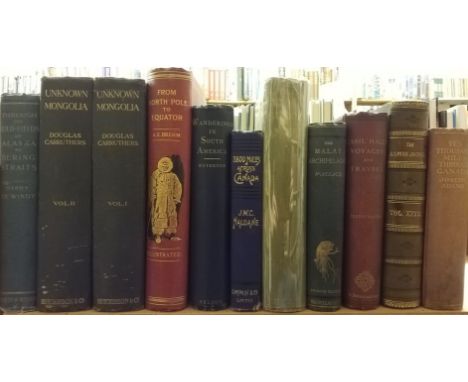
De Windt (Harry). Through the Gold-Fields of Alaska to Bering Straits, 1st edition, London: Chatto & Windus, 1898, 33 monochrome illustrations, the folding map of Alaska and the Yukon Gold-Fields is a facsimile replacement, some light toning, top edge gilt, publisher's original gilt decorated blue cloth, spine slightly faded & rubbed to head & foot, 8vo, together with: Carruthers (Douglas). Unknown Mongolia, a record of travel and exploration in North-West Mongolua and Dzungaria, 2 volumes, 2nd edition, London: Hutchinson & Co., 1914, 168 monochrome illustrations & 6 maps, some spotting throughout, publisher's original uniform blue cloth, boards & spines slightly marked & rubbed to head & foot, 8vo, plus Brehm (Alfred Edmund), From North Pole to Equator: studies of Wild Life and Scenes in Many Lands, London: Blackie & Son, circa 1890, 83 black & white illustrations, bookplate to front pastedown, minor marginal toning, top edge gilt, publisher's original gilt decorated red cloth, spine slightly faded, 8vo, and other late 19th & early 20th-century travel reference, including Wanderings in South America Etc., by Charles Waterton, 1st edition, London: Thomas Nelson and Sons, 1903, 8vo, mostly in original cloth, 1 volume in contemporary gilt decorated half calf, 8voQty: (11)
Lot 70
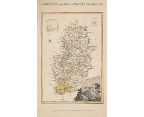
Nottinghamshire. Greenwood (C. & J.), A Map of the County of Nottingham from an actual survey made in the years 1824 & 1824..., Greenwood, Pringle & Co, 1826, large scale engraved map with contemporary outline colouring on four conjoined sheets, the whole laid on linen, calligraphic title, compass rose, table of explanation and an engraved panoramic vignette of Nottingham, several repaired marginal closed tears, some affecting the image. slight staining, dust soiling and toning, the lower margin attached to a near-contemporary stained wooden batten, 1380 x 1040 mm, contained in a purpose-made modern gilt cloth tube, together with Sanderson (George). This Map of the County of Nottingham from a Careful Survey, made in the Years 1834 & 1835 is Respectfully Inscribed..., 1836, engraved large scale map of Nottinghamshire with contemporary outline colouring on four sheets, calligraphic title, compass rose, table of explanation and a panoramic vignette of Webeck Abbey, some dust soiling and staining, several marginal closed tears with slight loss to the strapwork margins, some tears affecting image, each sheet laid on later paper, each sheet approximately 685 x 515 mm, together with another 7 county maps of Nottinghamshire, including examples by Harrison, Kitchin, Langley Gentleman's Magazine (publisher), Van den Keere and ButtersQty: (12)

Lot 73
Poland. Mewa (Atelier, publisher), Pologne, Crackow, circa 1935, colour printed lithographic poster of a map of Poland, old folds, 580 x 435 mmQty: (1)NOTESA promotional map of Poland published by the Atelier Mewa. The map depicts indigenous costume, topographical landmarks, flora & fauna, agriculture and industry in a stylised pictorial form.

Lot 74
* Spain & Portugal. Senex (John), Spain and Portugal Distinuish't into their Kingdoms and Principalities &c. According to ye Newest Observations..., 1719, engraved map with contemporary outline colouring, some creasing, 485 x 550 mm, mounted, framed and glazed, together with A Map of Greece with part of Anatolia..., 1720, engraved map with contemporary outline colouring, inset plan of Constantinople, slight overall toning, 485 x 570 mm, mounted, framed and glazedQty: (2)


Lot 77
The Map Collector, numbers 1 - 74 (complete), December 1977 - Spring 1996, numerous colour and black & white illustrations throughout, all with original publisher's printed wrappers, with the 3 (of 5) printed indices, and numerous loose supplements and inserts, slim 4to, contained in 4 purpose-made magazine filesQty: (77)

Lot 12
Nansen (Fridtjof). "Farthest North". Being a Record of a Voyage of Exploration of the Ship Fram 1893-96 and of a Fifteen Months' Sleigh Journey by Dr. Nansen and Lieut. Johansen, with an Appendix by Otto Sverdrup, Captain of the Fram, 2 volumes, London, George Newnes, 1898, folding map, monochrome illustrations, all edges gilt, original pictorial cloth blocked in gold and silver, in bright condition, 8voQty: (2)NOTESEx libris Constance Mary Butler, with her bookplate to front pastedown of each volume, and her inscription in purple ink to verso of front endpaper 'Constance Butler, Christiania, July 19th 1906'. Lady Constance Mary Butler (1879-1949), an Anglo-Irish noblewoman, yachtswoman and socialite, was a strong supporter of the Irish republican cause, who acted as President of the Irish Prisoner's Family Welfare Fund.
Lot 13
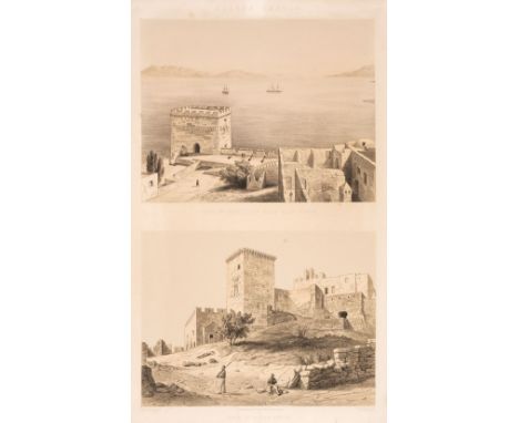
Newton (Charles). A collection of 31 plates from A History of Discoveries at Halicarnassus, Cnidus and Branchidae ..., London: Day & Son, [1862], 31 mostly tinted lithographed plates only, mostly antiquities and statues, with some half-page views, and including several uncoloured lithographed plans, from the total of 97 plates issued between 1862-1863, comprising plates: II, VI, VIII, IX, X, XII, XIV, XV, XXX, XXXII, XXXIV, XXXV, XXXVI, XXXVIII, XLIV, XLVI, XLVII, XLIX, LIV, LV, LVI, LVII, LIX, LX, LXXIV, LXXV, LXXVIII, LXXIX, LXXX, and LXXXIV, some marginal water-staining, light scattered spotting, most plates with several closed edge-tears and fraying, sheet size 55.5 x 37cm, with tinted lithograph title in similar condition, all loosely contained in original publisher's cloth gilt, heavy soiled and worn, large folio, together with: De Vaugondy (Robert), Asia Minor in suas partes seu provincias divisa, 1736, engraved map on two sheets, with outline hand-colouring, some fraying and minor staining to outer blank margins, sheet size 55 x 81cmQty: (2)NOTESAtabey 868; Blackmer 1192. Sold as a collection of plates, not subject to return.
Lot 14
Ogilby (John). Africa: Being an Accurate Description of the Regions of Aegypt, Barbary, Lybia and Billedulgerid... Collected and translated from the most authentick authors..., 1st edition, London: Thomas Johnson, 1670, title printed in red and black, 8 single page engraved plates only (lacking the frontispiece, general map and 43 double-page maps and plates), engraved illustrations in text, printed tables, final two leaves torn with loss of text, a few leaves detached, some frayed and insect predated fore margins, a few marginal wormtracks, some light soiling, contemporary boards, lacking all leather except remnant to spine only, worn, folioQty: (1)NOTESMendelssohn 3, p. 571; Wing O1631. Sold with all faults, not subject to return.
Lot 17
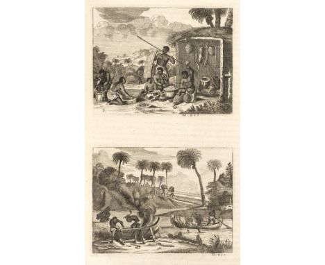
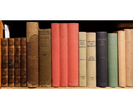
Thunberg (Charles Peter). Travels in Europe, Africa, and Asia, 4 volumes, 3rd edition, London: printed for F. and C. Rivington, 1795, 11 black & white engraved plates, some light toning & spotting, contemporary uniform gilt decorated mottled calf, spines rubbed, 8vo, together with; Andersson (Charles John), Lake Ngami; or Explorations and Discoveries, during four years' wanderings in the wilds of South Western Africa, 1st edition, London; Hurts and Blackett, 1856, monochrome illustrations, some spotting & toning throughout, rebound retaining publishers original gilt decorated brown cloth, repaired loss to head & foot of the spine, boards slightly faded & rubbed, 8vo, plus Colliard (François), On The Threshold of Central Africa..., 1st edition, London: Hodder and Stoughton, 1897, black & white illustrations, lacking map to the rear, contemporary previous owner inscription plus later stamps to the front endpaper, front & rear gutters cracked, some light spotting & toning, publishers original gilt decorated brown cloth, boards & spine slightly rubbed to head & foot, 8vo, and other late 19th & early 20th-century Africa travel reference, mostly original cloth, some rebound 8voQty: (30)
![[Southey, Robert]. A Summary of the Life of Arthur Duke of Wellington, from the period of his first achievements in India, to](https://cdn.globalauctionplatform.com/d3a06311-0b61-4c67-8749-ad7400bebae4/1a7fb5c0-8254-4b08-a0a0-ad7500aefc3b/468x382.jpg)
Lot 176
[Southey, Robert]. A Summary of the Life of Arthur Duke of Wellington, from the period of his first achievements in India, to his invasion of France, and the decisive Battle of Waterloo, June 18, 1815. Taken from the Quarterly Review. Dublin: printed for George Mullens, 1816, folding hand-coloured engraved map (with short closed tear and minor offsetting), a little minor spotting front and rear, all edges gilt, contemporary green blindstamped morocco gilt, joints and edges very slightly rubbed, small 4toQty: (1)NOTESLarge paper copy in handsome contemporary binding.
Lot 19
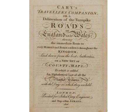
Cary (John). Cary's Traveller's Companion or a Delineation of the Turnpike Roads of England and Wales; shewing the immediate Route to every Market and Borough Town throughout the Kingdom..., London: John Cary, 1806, calligraphic title, advertisement and contents leaf, 43 engraved maps with contemporary outline colouring, (complete, including folding map of Yorkshire), dedication leaf & advert leaf for 3rd edition of Cary's New Itinerary detached, some light toning & offsetting, disbound 8voQty: (1)
Lot 2
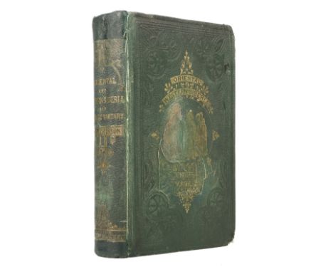
Atkinson (Thomas William). Oriental and Western Siberia. A Narrative of Seven Years' Explorations and Adventures in Siberia, Mongolia, the Kirghis Steppes, Chinese Tartary, and part of Central Asia, 1st edition, London: Hurst and Blackett, 1858, 20 chromolithograph and tinted lithograph plates, folding map at end (toned with reinforcements to verso), occasional light spotting, previous owner inscription of Charles Cotesworth, 1858 at head of title, endpapers renewed, original cloth gilt, rebacked with original spine relaid, lower corners worn, a little rubbed with a few stains, 8voQty: (1)
Lot 21
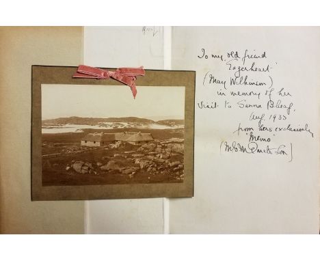
Donaldson (M. E. M.). Further Wanderings - Mainly in Argyll, 1st edition, Paisley: Alexander Gardner, circa 1933, inscribed by the author 'To my old friend "Eagerheart" (May Wilkinson)...', numerous monochrome illustrations, some light toning & spotting, original cloth in dust jacket, covers slightly toned & rubbed with minor tears & loss to head & foot, 8vo, includes a sepia photograph laid to card & inscribed on the back by the author, Ibid., Wanderings In The Western Highlands, 3rd edition, Paisley: Alexander Gardner, circa 1930, signed by the author to the title page, numerous monochrome illustrations some minor toning & spotting, publishers original cloth in dust jacket, covers rubbed with some loss to head & foot, 8vo, Ibid., Islesmen of Bride..., 1st edition, Paisley: Alexander Gardner, circa 1928, extra leaf inscribed by the author & laid down to the front endpaper, some minor spotting original cloth in dust jacket, 8vo, together with: Jakobsen (Jakob), An Etymological Dictionary of the Norn Language in Shetland, 2 volumes, 1st edition, London: David Nutt,1928, monochrome portrait frontispiece to volume 1, some light toning & spotting, original cloth in dust jackets, covers slightly toned & rubbed to head & foot, 8vo, plus Grieve (Symington), The Book of Colonsay and Oronsay, 2 volumes, Edinburgh: Oliver and Boyd, 1923, volume 2 inscribed hy the author to head of the half-title, folding map to the front of volume 1, monochrome illustrations, some light spotting & toning, original uniform cloth in dust jackets, spines toned & rubbed with slight loss, 8vo, and other early 20th-century Scotland reference, all original cloth in dust jackets, 8vo/4toQty: (16)
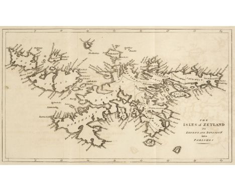
Lot 23
Gifford (Thomas). An Historical Description of the Zetland Island, 1st edition, London: J. Nichols, 1786, folding engraved map (with light offsetting), bound without the half title ('Bibliotheca Topographica Britannica No. XXXVII'), recent half calf, morocco label to spine, 4to, together with a modern facsimile copy of the same workQty: (2)NOTESESTC T84178. Forms volume 5, part 7 of Bibliotheca Topographica Britannica (1780-90).
![Lysons (Daniel). Topographical and Historical Account of Devonshire, 2 volumes, London: T. Cadell, [1822], engraved folding m](https://cdn.globalauctionplatform.com/d3a06311-0b61-4c67-8749-ad7400bebae4/cf2d94f6-f97a-4dad-ae2f-ad7500aeafd6/468x382.jpg)
Lot 27
Lysons (Daniel). Topographical and Historical Account of Devonshire, 2 volumes, London: T. Cadell, [1822], engraved folding map (browned, spotted & damp stained), numerous engraved plates (some folding), scattered spotting, browning and damp staining, bookplate of John Robert Mowbray to upper pastedown, late 19th century half calf, rubbed and some wear, 4to, together with two volumes of Lysons' Magna Britannia, volume 1, part 2 - Berkshire, and volume 5 - Derbyshire, London: T. Cadell, 1813 & 1817, both with folding county map and numerous engraved plates (some folding), some spotting, occasional damp staining and browning, Berkshire volume in contemporary red cloth, joints and head & foot of spine torn and worn, Derbyshire volume in contemporary half morocco, large 4to, together with Victoria County Histories, Hampshire and the Isle of Wight, 5 volumes, 1900-12, with index volume for Hampshire & Isle of Wight, 1914, and Sussex, volume 9 only, 1937, each in original red cloth, some joints split and extremities frayed, folioQty: (11)

Lot 32
Philip (George & Son publishers). Philip's Atlas of the Counties of England, circa 1886, title and contents list, general map of England and Wales and 48 (complete as list) double-page colour lithographic maps, very slight spotting, last three maps with slight creasing, index bound at rear, marbled endpapers, all edges gilt, contemporary half morocco gilt, slight staining to boards, re-backed but retaining original spine, rubbed and worn at extremities, folioQty: (1)
Lot 325
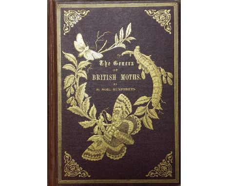
Humphreys (H. Noel). The Genera of British Moths, 2 volumes in 1, London: Paul Jerrard & Son, circa 1860, 62 colour plates, some minor toning, reinforced front & rear gutters, edges gilt, rebound retaining publishers original gilt decorated red cloth, spine faded with some loss to head & foot, large 8vo, together with; Sladen (F. W. L.) The Humble-Bee, its life-history and how to domesticate it..., 1st edition, London: Macmillan & Co, 1912, 34 black & white illustrations plus 6 monochrome plates, later inscription & ink stamp plus loss to head of the front endpaper, minor marginal toning, top edge gilt, publishers original gilt decorated brown cloth, spine lightly rubbed to head & foot, 8vo, plus Patterson (Robert Lloyd), The Birds, Fishes, & Cetacea of Belfast Lough, 2nd edition, London: David Bogue, 1881, monochrome map frontispiece, period inscription to the half-title, ex-library bookplate to the front pastedown, some light spotting & toning, publishers original gilt decorated green cloth, boards & spine lightly rubbed to head & foot, 8vo, and other 19th & early 20th-century 'picture cloth natural history reference, including Charles Dixon, Oliver G. Pike, C. A. Johns, Frank Buckland, all in original gilt decorated cloth, overall condition is good/very good, 8vo 60 volumesQty: (3 shelves )
Lot 328
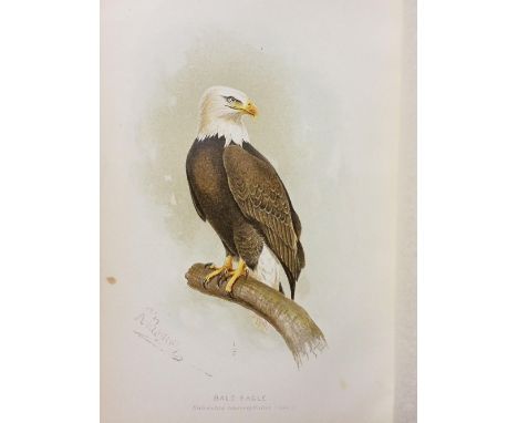
Fisher (A. K.) .The Hawks and Owls of the United States in their relation to agriculture [U. S. Department of Agriculture... bulletin no. 3], Washington: Government Printing Office, 1893, 26 colour plates with tissue guards, bookplate to front pastedown, some marginal toning throughout, publishers, original brown cloth, spine slightly rubbed to head & foot, 8vo, together with; Cave (Francis O. & James D. Macdonald), Birds of The Sudan, their Identification and distribution, 1st edition, Edinburgh: Oliver and Boyd, 1955, 12 colour plates plus numerous black & white illustrations & folding map to the rear, period inscription to the front endpaper, typed letter on 'British Museum' headed notepaper dated 17th May, 1955 to Col. G. Goodwin by & signed J. D. Macdonald, some light spotting, publishers original blue cloth, boards & spines slightly rubbed to head & foot, 8vo, plus Gosse (Philip Henry), The Birds of Jamaica, 1st edition, London: John van Voorst, 1847, period inscription to the front endpaper, bookplate to front endpaper, ink stamp to the title page, some marginal toning, original embossed green cloth, spine lightly faded & rubbed, 8vo, and other late 19th & early 20th-century ornithology reference, including Birds of the Eurasian Tundra [Memoirs of the Boston Society of Natural History volume 6, number 3], by Theodore Pleske, 1st edition, Boston: printed for the Society, April 1928, large 4to, mostly in original cloth, G/VG, 8vo/4toQty: (3 shelves)

Lot 329
Borlase (William). The Natural History of Cornwall..., new edition, London: E & W Books, 1970, monochrome illustrations & folding map, some light spotting to the text-block, top edge gilt, original cloth in price-clipped dust jacket, folio, limited edition if 350 copies, together with; Henrey (Blanche), Britush Botanical Horticultural Literature before 1800, London: Oxford University Press, 1975, colour & monochrome illustrations, publishers original uniform blue cloth in slipcase, 8vo, plus Taubert (Sigfred), Bibliopola, 2 volumes, London: Allen Lane The Penguin Press, 1966, numerous monochrome illustrations, publishers original uniform cloth in slipcase, large 8vo, and other modern bibliography reference & related, including publications by Edinburgh University Press, Yale, Oxford, Minerva, Witherby, mostly original cloth, many in dust jackets, G/VG, 8vo/folioQty: (4 shelves)
Lot 336
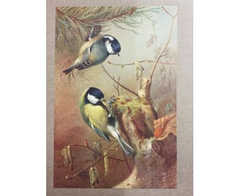
Thorburn (Archibald). British Birds, 4 volumes, limited edition, London: Longmans, Green and Co., 1925, numerous colour plates, bookplates to the front pastedowns, some light spotting, top edges gilt, publishers original uniform gilt decorated red cloth, 8vo, 70/205 copies, together with; Swainson (Charles), The Folk Lore and Provincial Names of British Birds, London: Folk Lore Society, 1886, pencil annotations to the front endpaper, some light spotting, publishers original gilt decorated red cloth, boards & spine lightly rubbed, 8vo, plus Chapman (Abel), Bird-Life of the Borders on Moorland and Sea..., 1st edition, London: Gurney and Jackson, 1907, colour folding map, monochrome illustrations, bookplate to front pastedown offset to the front endpaper, some light toning, top edge gilt, publishers original green cloth, boards & spine slightly faded & rubbed to head & foot, 8vo, and other 19th & early 20th-century British ornithology reference, including a 2 volume sammelband of 'Ornithology and other Pamphlets ', circa 1900, 8vo, mostly original cloth, G/VG, 8vo/4toQty: (3 shelves )
-
109182 item(s)/page