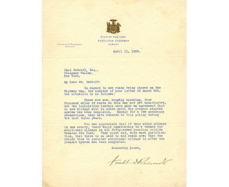

ROOSEVELT FRANKLIN D.: (1882-1945) American President 1933-45. T.L.S., Franklin D Roosevelt, one page, 4to, Albany, New York, 11th April 1929, to Paul DeGroff, on the printed stationery of the State of New York, Executive Chamber. Roosevelt writes to his correspondent to explain the situation regarding new roads being placed on a Highway Map, 'There are now, roughly speaking, four thousand miles of roads on this Map not yet constructed, and the legislative leaders have made an agreement that no new mileage will be added until the present adopted system has been completed. Except for a few necessary connections, they have adhered to this policy during the last three years. You can appreciate that if they added mileage in one county, there would immediately be a demand for additional mileage in all fifty-seven counties outside Greater New York. They point out, with much justification, that there is no need to add roads now; that the proper time to consider additional mileage is after the present system has been completed'. Accompanied by the original envelope. Some extremely light, very minor age wear, VG, 2 £200-300 Roosevelt served as Governor of New York from 1929-32.
We found 109198 price guide item(s) matching your search
There are 109198 lots that match your search criteria. Subscribe now to get instant access to the full price guide service.
Click here to subscribe- List
- Grid
-
109198 item(s)/page


A G. F. Cruchley's table 10" globe, 12 hand coloured engraved gores, The Catourche 'Cruchley's new terrestrial globe showing the latest discoveries towards the North Pole, equatorial Africa, Australia, New Zealand & C. London G.F. Cruchley map seller, globe maker and publisher, 81 Fleet Street, London. Dated 1867. The globe is seated in a replacement mahogany stand. Globe Diameter 24cm. Height with stand 32cm.


Various Railway Related Paperwork including Railway Clearing House Map on England & Wales 1897 (lack one section to top right hand corner), NER Timetables July-September 1914, LNER Locomotiveman's Pocket Book, LNER Timetables mostly dating to 1926, NER Working Timetable undated, LNER Co. List of Lines 1926 (Excellent condition) and various other mostly BR related items


LONDON: a collection of approx 75 books, pamphlets, guides and maps relating to London, largely late 19th-early 20thc publications, to include Daily Telegraph Postal Map of London, pub. Geographia: six Ward Lock Red Guides to the capital, to include The Festival Edition for 1951 in dustjacket: 'A Record of the Honoured Men of Wimbledon & Merton who fell in the Great War 1914-18', 1921: various formats and bindings, generally in good condition. (2 shelves)

BRITISH TOPOGRAPHY: SMITH (Charles): 'The Antiquities of Richborough, Reculver and Lymne, in Kent...' London, John Russell Smith, 1850: square 8vo, publisher's blind stamped blue cloth, hinges a little frayed: 'The Oxford University & City Guide, on a new plan', Oxford, Henry Slatter, n.d. (circa 1860): recent red cloth preserving original backstrip, folding map and steel engraved plates: together with a quantity of other British topography over 5 shelves, chiefly 19th & 20th century publications, various sizes and formats, generally in good condition. (5 shelves)
INDIA: a miscellany in one carton, 19th-20thc material to include, 'East Indian Railway Company, Map to Accompany the Report of Directors, dated 15th April 1856', large folding map printed on paper and laid onto linen, some marks and spotting: TOGETHER WITH other folding maps, prints/engravings and ephemera, with a copy of Baden-Powell's 'The Origin and Growth of Village Communities within India', 1899. (A box)

FOLIO SOCIETY: DOUGHTY (C M): 'Travels in Arabia Deserta..' London, The Folio Society, 2013. Limited edition No.439/780 numbered copies: 3 vols inc. folding map in boards, the 2 text vols bound in brown half goat skin gilt lettered, the whole contained in publishers brown buckram slipcase, large 8vo, VG. (3)


Collection of maps: J. Blaeu 17th-century map of Bedfordshire, copper engraving on laid/chain-lined paper with English & French text to verso; a pair of 19th-century Thomas Moule maps of Cambridgeshire and Yorkshire West Riding; a pair of 18th-century Robert Morden maps of Buckinghamshire and East Riding of Yorkshire; Robert de Vaugondy map of Normandie, 1751; and two large Ordnance Survey maps of Yorkshire West Riding, 'Revision of 1935'. (8)


![Johannes Blaeu (Dutch, 1596-1673), Wales, Wallia Principatus vulgo Wales, published Amsterdam, [1645 or later], decorative ca](https://cdn.globalauctionplatform.com/e4260346-f460-42b0-9131-a81d00c3f2e4/46805b82-ff02-4e08-cc88-bb72edaaf630/468x382.jpg)
Johannes Blaeu (Dutch, 1596-1673), Wales, Wallia Principatus vulgo Wales, published Amsterdam, [1645 or later], decorative cartouche, Spanish text on verso, hand coloured engraved map, plate size 38.5 x 50cm.; 15.25 x 19.75in. For condition report please see the catalogue at www.peterwilson.co.uk

Herman Moll (1654-1732), A New Map of Great Britain, according to the Newest and most Exact Observations, 1726, with inset map of the Orkney and Shetland Islands, printed and sold by Thomas Bowles next the Chapter House in St. Paul's Churchyard, John Bowles at the Black Horse in Cornhill and by John King at the Globe in the Poultrey near Stocks Market, hand coloured engraved map, 103.5 x 62.5cm.; 40.75 x 24.75in. For condition report please see the catalogue at www.peterwilson.co.uk

John Senex (1678-1740), A New Map of Great Britain Corrected from the Observations communicated to the Royal Society at London, with inset map of the Orkney and Shetland Islands and decorative title and dedication cartouches, engraving with hand colouring on two sheets joined, 98 x 68cm.; 38.5 x 26.75in. For condition report please see the catalogue at www.peterwilson.co.uk


BOWEN, Emanuel (1693-1767), An Accurate Map of the County of Lancaster Divided into its Hundreds, from the Large English Atlas, sold by John Bowles & Son in Cornhill & Robert Sayer in Fleet Street, London 1753, hand coloured engraved map, 71 x 54cm.; 28 x 21.25in. For condition report please see the catalogue at www.peterwilson.co.uk

A Complete Set of 40, Sterling Silver Medals 'The Ancient Counties of England,' issued by the Birmingham Mint 1975 to commemorate the boundary changes to English counties 31 March 1974; the obvs depict a building or other well-known landmark associated with each county; the set also includes a reproduction map of England dated 1635 & a booklet with detailed historical notes on each county; together with thirty five silver medallions for churches and cathedrals
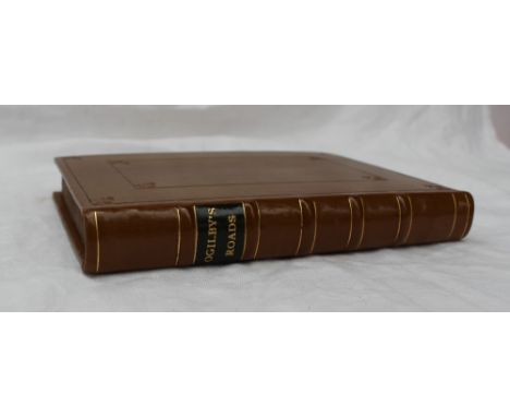
Bowen (Emmanuel). Britannia Depicta or Ogilby Improv'd being a correct coppy of Mr Ogilby's actual survey of all ye Direct & Principal cross roads in England and Wales..., 2nd edition, London printed for & sold by Tho. Bowles, Print & Map seller next ye Chapter House in St. Pauls Church-Yard & E. Bowen Engraver & Print Seller near ye stairs in St. Katherines, 1720, [1721], engraved title, four pages of tables & maps, 273 uncoloured engraved county maps and strip road maps printed back-to-back, CONDITION REPORT: Rebound
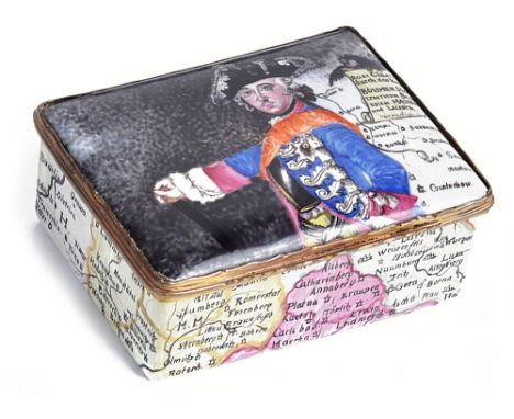
A GERMAN ENAMEL SNUFF BOX, PROBABLY BERLIN, CIRCA 1755the lid with a half length portrait of Frederick the Great after Antoine Pesne (1683-1757) flanked by part of a map of the Kingdom of Bohemia and Duchy of Silesia, the map continuing over the sides and base, the interior lid with a portrait of his wife Elisabeth Christine, Queen of Prussia, gilt metal reeded and scalloped rim mounts8.2cm wideProvenance: The Hoffenreich Collection of Snuff Boxes, Vienna
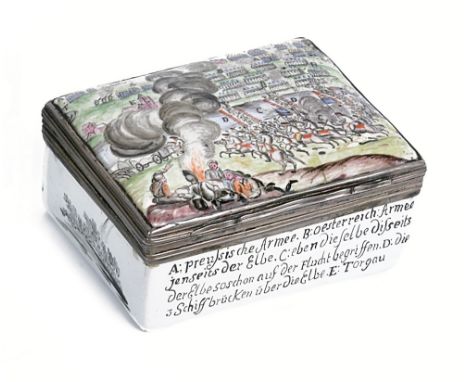
A GERMAN ENAMEL SNUFF BOX, PROBABLY BERLIN, CIRCA 1761commemorating the Battle of Torgau (3 November 1760), rectangular, the lid painted with the order of engagement, the front and back sides with key to the scene on the lid, interior lid with map of the surrounding area, and base with the date of battle, unmarked reeded silver rim mounts8.2cm longProvenance: The Hoffenreich Collection of Snuff Boxes, Vienna

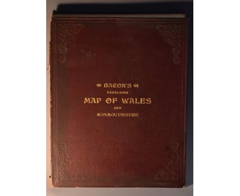
Bacon's Excelsior Map of Wales and Monmouthshire, Revised According To The Latest Ordnance Survey, With Railways, Roads, and Distances, [printed and published by] G.W. Bacon & Co. Ltd., London [c. 1900], twenty-five chromolithographic and hand-coloured folds laid on canvas, maroon buckram boards, marbled endpapers, square 4to

Railwayana - Map & Section of the Railways of Great Britain, Dedicated by Permifsion (sic) To James Walker, F.R.S, L & E., President of the Institution of Civil Engineers by George Bradshaw, Engraved by I. Dower [...] London, Published by G. Bradshaw, Manchester 1839, Sold by J. Gardner, London, forty-nine fold engraved map laid on canvas, hand-coloured delineations, 166cm x 104cm overall, disbound from covers

English School (early 20th century), nautical map or chart, Halifax to the Delaware, North America - East Coast, Engraved by Davies & Company, Published at the Admiralty [...] under the Superintendant of Rear Admiral W.J.L. Wharton [...] Large corrections, Sold by J.D. Potter, London 1908, twelve-fold map, 69cm x 99cm

-
109198 item(s)/page