We found 109198 price guide item(s) matching your search
There are 109198 lots that match your search criteria. Subscribe now to get instant access to the full price guide service.
Click here to subscribe- List
- Grid
-
109198 item(s)/page


Lot 11
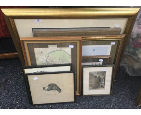
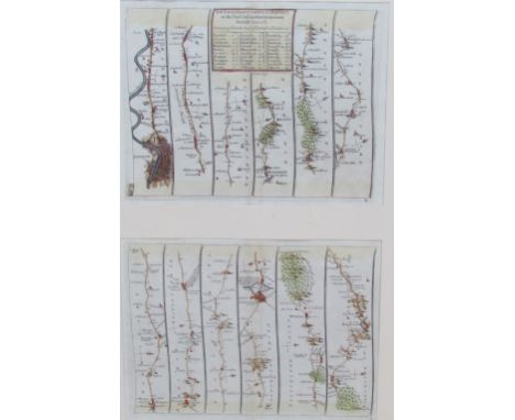
Two 18th century coloured maps of Italy to include a map of Italy with its Kingdoms, States from Mr Tindal's Continuation of Mr Rapin's History, 48 x 39cm together with Map from the Expedition of Hannibal from the understanding of Mr Rollin's Roman History, 48 x 30cm, both in mounts but unframed (2)


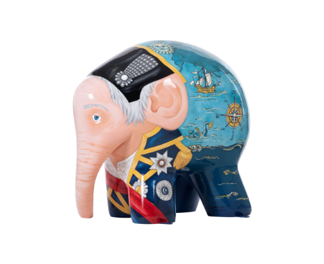
Lot 50
Lord Admiral NellyThis design was inspired by the great East AnglianNaval Commander, Lord Admiral Horatio Nelson.The English hero had strong links to Ipswich; witha country home at Roundwood House, he was anhonorary freeman of the town and, in 1800, wasmade high steward of Ipswich. Depicting ‘Nelly’ infull naval uniform complete with medals, there isa vintage nautical feel to the design. A map of theseven seas adorns the rear of the sculpture featuringseveral ships including HMS Victory - Nelson’sflagship at the battle of Trafalgar.Logistics partner: Palletways Palletways is Europe’s largest pallet delivery network.With over 400 depots strategically positionedacross 20 countries, we’re unrivalled in our ability toconnect your business to the continent. Our growingpallet delivery network now delivers up to 40,000pallets every day with the help of over 400 partnernetwork members. We combine both our resourcesand connections to ensure goods are deliveredfast and efficiently, leaving our customers to focuson growing and managing their businesses. Withindustry leading customer satisfaction levels, we arethe pallet delivery partner of choice for hundreds ofbusinesses across Europe. Working side by side withour members, we aim to be the leading Internationalpallet delivery network service provider.www.palletways.comArtist: Donna NewmanDonna Newman is a freelance mural artist workingin Birmingham and the surrounding areas, where sheseeks to inspire young people by transforming theirlearning environments with her vibrant artwork.Trained as a painter at Coventry University, Donnaresponds with creativity and flair to her client’sspecifications producing original designs in a hugevariety of subjects. She is also an experiencedpainter of sculpture trails working closely withWild in Art on several commissions. Working innumerous locations and on various surfaces, Donnais an extremely versatile artist who brings colour andlife through her art.

Lot 48
This design is a total fantasy on the word ‘Trunk’.All elephants have trunks; Elmer has just goneone step further and had a travelling trunk madefor all his travels. Except he outgrew it, but stillinsists on wearing it anyway! He has travelled allover the world and collected a few stickers onthe way... The trunk has been fitted to perfectlysuit his needs, with easy reach pockets full of hisessential travelling things - even a map of Ipswichready for the parade.Sponsor: Fred. Olsen Cruise Lines Fred. Olsen Cruise Lines is one of the world’sbest-known and best-loved holiday brands. It hasbeen specialising in providing high-quality cruiseexperiences since 1988, when it established itsheadquarters in Ipswich, Suffolk. Operating fourclassic ocean cruise ships - Balmoral, Braemar,Boudicca and Black Watch - as well as newriver cruise addition, Brabant - Fred. Olsenis renowned for its award-winning customerservice, excellent cuisine and friendly ‘homefrom-home’ atmosphere. Visiting over 200destinations each year, family-run Fred. Olsenprides itself on ‘bringing the world closer’.www.fredolsencruises.comArtist: Angela Ashford,The Ashford StudioAngela Ashford has worked in many styles andmediums over the years. She could be said tobe an all round artist, as she has painted largemurals in churches, portraits, cartoons, spiritualart (paintings based on biblical truths), and morerecently she has had great fun painting comicalpeep boards. Art has always been Angela’spassion, especially working in detail. She worksfrom home in her studio, where she takes onportraits and other commissions.

Lot 12
Tree Trunk is a fun play on words that createsan enveloping woodland scene with birds ofparadise, butterflies and flowers to connect usback to nature and make us smile - a breath offresh air in the centre of town. Design partner: Firebrand Creative Firebrand were delighted to help St ElizabethHospice as official design partners for Elmer’s BigParade Suffolk and have volunteered their timeto create a whole range of pieces for the eventincluding the Parade Map, Learning Herd Guide,banners, plaques on the sculptures and even thisSouvenir Guide!www.firebrandcreative.comArtist: Firebrand CreativeThe team at Firebrand Creative have reallyenjoyed collaborating with Ipswich based artistJessica Bradley to bring ‘Tree Trunk’ to life.Firebrand Creative specialise in branding,marketing and design; creating or refreshingvisual identities to make them enduring andmemorable. Established and based in Ipswichsince 1997, they work with clients from allsectors, both big and small.
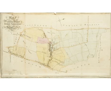
Lot 196
London.- Robinson (William) The History and Antiquities of the Parish of Stoke Newington, in the County of Middlesex, folding hand-coloured engraved map frontispiece, 14 plates, folding map, illustrations, occasional faint off-setting, later half-calf, upper cover detached, rubbed and worn, 1820; The History and Antiquities of the Parish of Tottenham High Cross, in the County of Middlesex, Middlesex, hand-coloured engraved map frontispiece, small marginal tears, neatly repaired, 16 engraved plates only (of 18), occasional faint spotting and off-setting, modern cloth, for the author, by G. S. Coventry, 1818; The History and Antiquities of the Parish of Edmonton, in the County of Middlesex, folding double-page hand-coloured engraved map frontispiece, one or two short marginal tears, small marginal ink stain, 9 engraved plates, engraved folding map, illustrations, occasional faint damp-staining, short repair neatly repaired (K1), modern half calf, 1819, first editions, ex-library with label to front pastedown, 8vo (3).
![Middle East.- [Bell (Gertrude)] The Arab of Mesopotamia, Basrah, map, browned, strengthened joints, original cloth, rubbed, s](https://cdn.globalauctionplatform.com/301ad9da-51ab-4cd1-ae03-aaa30115c199/22414483-1917-4b97-b308-aad400bfb136/468x382.jpg)
Lot 182
India.- Pennant (Thomas) The View of Hindoostan, 2 vol., first edition, engraved frontispieces, 2 headpieces, 19 plates, 1 hand-coloured, large folding map (small tear), both lacking half-titles, modern half-morocco over marbled boards, 4to, 1798.⁂ This was originally projected to be a 14 volume work titled "Outlines of the Globe" though a total of only 4 volumes were published, with only this work published in the author's lifetime.
Lot 115
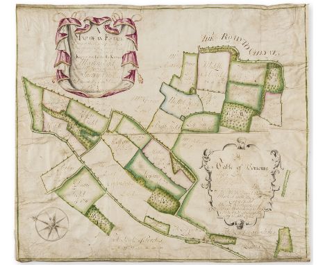
Berkshire Estate map.- The Plan of John Glover's Farm Lying in the Parish of Sulhamstead Bannester Stratfield Mortimer and Burfield, manuscript estate map with gold decorated floral watercolour wash cartouche and gold decorated compasses, watercolour wash map in green and pink, on vellum, title within cartouche, all within a green watercolour wash border, left corner torn and repaired, some slight creasing and soiling to edges, 520 x 655mm., [c. 1750].
Lot 177
Europe.- Breval (John Durant) Remarks on Several Parts of Europe: Relating chiefly to the History, Antiquities and Geography of those Countries, 2 vol. in 1, first edition, engraved frontispieces, double-page engraved map, 43 plates, 12 folding or double-page, subscriber's list, one or two short marginal tears, occasional faint off-setting, bookplate, contemporary calf, rebacked with the original spine laid down, a little rubbed, folio, Bernard Lintot, 1726.
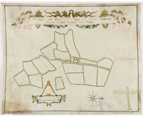
Lot 114
Buckinghamshire & Hertfordshire Estate Map.- Hailey (John, surveyor of Amersham) A Map of an Estate Lying in the Parishes of Standen & Chesham and in the County of Hertford and Buckingham Known or called b y the Name of Martins End Late Mr. Richard Princes Decd..., manuscript estate map with watercolour wash, on vellum, title within cartouche, all within a green watercolour wash border, some creasing, some slight surface wear in margins, 540 x 630mm., 1743.

Lot 165
Dorset.- Hinton St. Mary, near Sturminster... Estate... Hinton Manor House... 150 Acres of capital Land... Sold by Auction, by Mr. W.H. Hewitt, 7pp., large hand-coloured folding lithographed map of Hinton loosely inserted, folio, 1852; and 8 other sale particulars of properties in Dorset, folio (9).
Lot 190
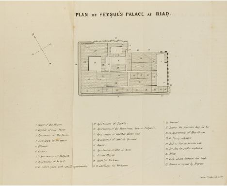
Middle East.- Palgrave (William Gifford) Narrative of a Year's Journey through Central and Eastern Arabia (1862-63), 2 vol., first edition, hand-coloured folding map, tear (repaired), 4 folding lithographed plans, occasional soiling, ex-library with labels to front pastedowns, contemporary half calf, rubbed and worn, Cambridge, 1865
Lot 189
Middle East.- Doughty (Charles M.) Travels in Arabia Deserta, 2 vol., first edition, half-title to vol. 1 only, strengthened at joint, vol. 2 title strengthened at joint, folding plates, 1 with tears, tape repairs, illustrations, folding colour map and plate loosely inserted, 1 or 2 short marginal tears, publisher's catalogue at end (vol. 1 only), ex-library with label remnants to front pastedown and usual stamps, occasional marginal soiling, later cloth, rubbed and worn, 8vo, Cambridge, 1888.⁂ Classic work on the exploration of Arabia with so much information on the topography of the area that it was used as a text-book by the British army during the Arab Revolt. There are also detailed descriptions of the Bedouin tribes and their customs.
Lot 48
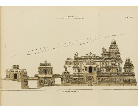
Indian Art.- Fergusson (James) and James Burgess. The Cave Temples of India, first edition, wood-engraved frontispiece and illustrations, folding map, 99 plates including one mounted albumen print, a few tinted, 2 folding, with a duplicate of plate XVIII, very occasional spotting, map creased, Breezewood book-label, contemporary half morocco, t.e.g., spine gilt, rubbed, 1880; History of Indian and Eastern Architecture, first edition, wood-engraved frontispiece and illustrations, light foxing at beginning and end, modern half morocco, t.e.g., 1876, 4to & 8vo (2)⁂ James Fergusson (1808-86), originally an indigo planter in India later became an architectural historian and respected authority on Indian architecture and its cave temples in particular. The first work was co-produced with the archaeologist James Burgess who from 1886-89 was Director General of the Archaeological Survey of India.

Lot 193
NO RESERVE Voyages.- Cochelet (Charles) Narrative of the Shipwreck of the "Sophia"... on the Western Coast of Africa and of the Captivity of a part of the Crew in the Desert of Sahara, folding engraved frontispiece map and 7 plates (2 folding), 1822 bound with Kotzebue (Otto von) Voyage of Discovery in the South Sea, and to Behring's Straits, in Search of the North-east... in the Ship Rurick, 2 parts in 1, 4 folding engraved charts and 10 plates only of 16, 1821, bound with 2 other pamphlets, foxed and browned, broken in two, contemporary half calf, worn, covers detached, forming vol. VI New Voyages and Travels... Printed for Sir Richard Phillips & Co., 8vo.

Lot 148
China. A photograph album compiled by an unidentified naval officer serving onboard HMS Aphis with the Yangtze Flotilla in northern North China, 1931-33, a total of approximately 210 gelatin silver print photographs corner-mounted on rectos and versos of 21 paper leaves, images mostly 7 x 9.5cm and mounted as multiples of five or six to a page with white china ink captions, some photographs with printed captions in the negative, captions include Views of the Gorges, Upper Yangtze, Scenes in Kinkau, Kwankau, Yolushan, Changsha, Hankow (including the Great Flood, 1931), Nanking, Shanghai, Ichang, Peking, Chefoo, etc., evidence of some photographs removed, some leaves detached, white china ink title, itinerary and map to front pastedown, contemporary black silk over boards with embroidered dragon design and spine tie, rubbed and a little corner wear, oblong folio (Qty: 1)


Lot 28
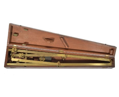
A George IV brass pantograph Cary, London, circa 1825 The pivoted frame with circular dark green silk covered anchor-weight fitted to an adjustable slider against engraved ratio scale to one arm opposing fixed pencil holder to the other, the centre with subsidiary pivoted armature with further adjustable slider against a similar scale for the tracing stylus and signed Cary, London to the opposing member, fitted with removable bone wheel castors to each junction/terminal, in original mahogany box with tracing pointer and weighted pencil carrier, the box 73.5cm (29ins) long. William Cary is recorded in Clifton, Gloria Directory of British Scientific Instrument Makers 1550-1851 as born circa 1759 and apprenticed to Jesse Ramsden. William worked from 272 Strand, London 1789-90 then 182 Strand 1794-1822, he died in 1825. John Cary (I) is recorded by Clifton as a map, globe and chart engraver who was born in 1755 and worked from Johnson's Court, Fleet Street 1782 then Corner of Arundel Street, Strand 1783 before moving to 188 Strand 1783-1790 followed by 181 Strand 1792-1805. He is last recorded working at 86 St. James Street 1820-21. The business was continued by John (II) and George Cary (both sons of John senior) until circa 1851 when it was acquired by Henry Gould.
-
109198 item(s)/page