We found 108737 price guide item(s) matching your search
There are 108737 lots that match your search criteria. Subscribe now to get instant access to the full price guide service.
Click here to subscribe- List
- Grid
-
108737 item(s)/page


Lot 255
J. Cary, engraving, coloured map of Hampshire, from the best authorities. Engraved by J.Cary, published by John Stockdale, Piccadilly, 26th March 1805. 54cm x 45cm. Framed and glazed. Together with a later coloured Thomas Moule map engraving 'Rutlandshire', inscribed verso 'presented by RAF North Luffenham Wives' Club and Thrift Shop to AMJ on 1st November 1982'. (2)
Lot 217
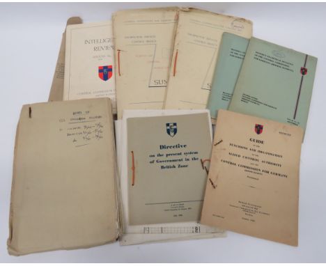
Good Selection of Control Commission Germany Documents including Intelligence reports for Aug 1946, Sept, Oct, Dec Jan 1947, Feb. Printed covers with CCG badge ... Directive In The British Zone July 1946 ... Guide To The Organisation Oct 1945 ... 6 x Information Service Control Branch booklets, 1946 ... Staff Course Notts CCG College ... CCG map of British zone of Germany. Formerly property of Lt Col R N Hamilton
Lot 223
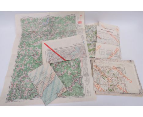
Good Set of Overprinted Army Of Occupation Maps of Germany captured German maps of Ireland and Wales and Europe with Cancelled stamps to the them and the reverse reprinted with map of Germany. Printed by the Allies, mostly dated 1945. Good selection of German areas including Drolshagen ... Peine ... Salzwedel ... Marsberg ... Nienburg ... Hannover. 50 items.

Lot 234
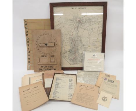
Selection of No 23 (37th GPO) Batt Hampshire Home Guard Paperwork all relating to Lt-Col R N Hamilton. Including Christmas 1944 card ... 5 x blank Home Guard Registers of Attendance ... 10 x blank Proficiency certificates ... Printed list of Officers, Warrant Officers and Platoon Commanders ... 2 x maps of Portsmouth ... Framed map of Portsmouth showing rest centres and emergency feeding centres. Quantity.

Lot 335
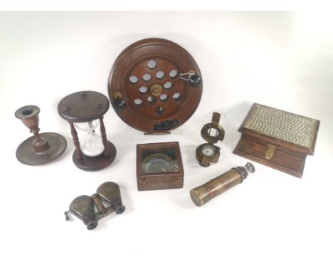
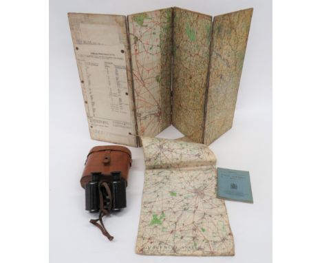
Good Selection of Various Equipment including 1908 pattern webbing, small bag. Internal date faint. Various post war stamps ... Pair of Officer pattern field binoculars. Complete in leather case ... Khaki covered waterbottle, complete in leather harness ... Waterproof canvas, Officer's folding map case ... Canvas, Far East survival waterbottle.

Lot 345
WW2 Officer's Large Map Case and Maps canvas covered wooden body. The front with pencil pocket and rear with large pocket. Complete with an Egyptian issue map Matruh Egypt and Western Desert, dated October 1941. Similar map Cairo, dated May 1941. Together with a copy report of British escapees Lt A.M.S. Neave & Capt H A Woollatt concerning equipment and escape routes.
Lot 363
Attributed WW1 Binoculars and Battle Map pair of Goerz Berlin field binoculars with blackened mounts and leather covered body. Central adjustment dials. Lower mounts engraved EPM Robinson Loyal North Lanc Regt. Leather neck strap. Contained in their fitted leather case. Inner lid with white metal label named Capt H Pennington Robinson. Front of case with marked E.P.M.R. ... Battle map 12/7/16 on folding map board covering the Arras area in various scales ... Linen backed, paper map Valenciennes ... Field Almanac 1918. 4 items. Estate of E P M Robinson Loyal North Lancs & RFC
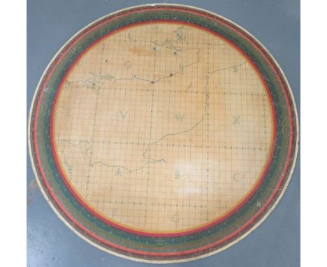
Lot 419
Rare Possibly Unique Aircraft Plotting Table circular table top. The edge with various scale markings for Kingsdown, Farningham, Carisbrooke, Medstead, Bury, Beachy, Friston and Southminster. Central line drawn map covering the south coast and French coastal line, all with marked grid system. Together with a wall mounted counter display Army Plotting Table Display (some markings absent) ... 6 x various alloy plotting stands with display numbers ... Various table markers.


Lot 5061
MAP OF THE NORTH RIDING OF THE COUNTY OF YORK from an actual survey made in the years 1817 and 1818 by C. & J. Greenwood corrected to the present period and published April 1st 1834, framed and glazed 61cm by 76cm; AND THE NORTH RIDING OF YORKSHIRE, BY ROBERT MORDEN, hand coloured, framed and glazed 37cm by 42.5cm (2)

Lot 408
Antiquarian Folding Map. Italy. Carte Physique & Routiere de L'Italie. Par J. Andriveau-Goujon. Paris: 1832. In 48 folding cloth-backed sections. Outline colour. Measures approx.: 121cm x 98cm. Housed in a cloth and marbled paper case. A few minor ink splashes to a couple of sections, overall in VG condition. (1)


Lot 27A
Antique 17th century 'WIGORNIENSIS COMITATUS SABRINAE' hand coloured Map (Worcestershire) by Saxton.This is the earliest printed map of the county which can be acquired at an 'affordable' price and was engraved by William Hole who is also one of the earliest recorded English map engravers.This particular example is from the 1637 edition which had the (plate) number '30' added to the bottom left of the map.


Lot 49
Quadrophenia signed the making Of Limited Boxset Edition book by Simon Wells. Hand Signed by Franc Roddam (Film Director) and Simon Wells. Boxset Limited Edition - 500 copies. New & Unread, opened only to take photo of the signatures. The Making of Quadrophenia is the definitive account of Britain's greatest youth movie, containing behind-the-scenes photographs and interviews from principal cast members, director Franc Roddam, producer Bill Curbishley, scriptwriter Martin Stellman and many others. This deluxe box-set edition – limited to 500 copies – is hand signed by both Franc Roddam and Simon Wells, and contains the following exclusive items: A specially designed, illustrated map of the movie locations in Brighton. A reproduction of an original Japanese promotional brochure. A print of an Adrian Boot photograph taken on set. A set of four postcards featuring rare international posters. A certificate of authenticity, this is VERY rare!
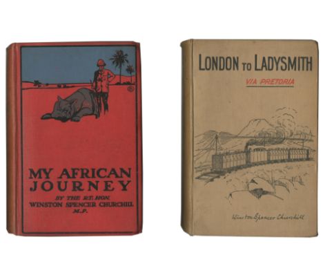
Lot 112
CHURCHILL (WINSTON)London to Ladysmith via Pretoria, FIRST EDITION, 8 maps and plans (3 folding), 2pp. advertisements and 32pp. publisher's catalogue at end, one folding map with edges slightly frayed and browned, publisher's pictorial cloth [Cohen A4.1.a; Woods A4], Longmans, Green and Co., 1900; My African Journey, FIRST EDITION, 3 maps and numerous plates (one soiled at edges), light spotting, publisher's pictorial red cloth, spine a little faded and stained, recased [Cohen A27.1; Woods A12], Hodder & Stoughton, 1908; The People's Rights, FIRST EDITION, FIRST ISSUE IN WRAPPERS, second state with p.71 corrected, one appendix and index at end, paper toned as usual, publisher's yellow wrappers with portrait on front wrapper (fore-edge chipped not affecting lettering), spine creased with some loss at foot, rear wrapper detached with loss to part of one advertisement [Cohen A31.2.b; Woods A16], Hodder & Stoughton, [1910]--NOBLE (WALTER) With a Bristol Fighter Squadron... with an Introduction by... Winston Churchill, FIRST EDITION, portrait and 2 plates, The John Crerar Library (Chicago) copy with bookplate, ink stamp on verso of plates, and perforated stamp on title, publisher's cloth, spine ends bumped, [Cohen B23.1; Woods B7], Andrew Melrose, 1920, 8vo (4)This lot is subject to the following lot symbols: •• Zero rated for VAT, no VAT will be added to the Hammer Price or the Buyer's Premium.For further information on this lot please visit Bonhams.com
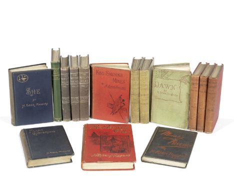
Lot 124
HAGGARD (HENRY RIDER)Cetywayo and His White Neighbours, ownership inscription (1887) on title-page, early newspaper review tipped-in page facing title [Sadleir 1082], Trubner & Co., 1882; Dawn, 3 vol., [LIMITED TO 500 COPIES], 20 pages of advertisements ([4], 16pp.) at end of volume 3, final free endpaper of volume 1 torn with loss to one corner, hinges weakened (cracked in volume 1), some old adhesions marks on paste-down endpapers [Sadleir 1085; Wolff 2851], Hurst and Blackett, 1884; King Solomon's Mines, second issue or 'binding up' of 500 copies (with advertisments dated '10.85'), folding colour lithographed map (2 tears), 16pp. of advertisements, light dampstain at fore-edge margin from title through to pp.32, old paper reapair to joints [Sadleir 1089; Woolf 2863, with ads dated '8.85], Cassell & Co., 1885; The Witch's Head, 3 vol., [LIMITED TO 500 COPIES], volume 3 with half-title and 8pp. of advertisements at end, without half-titles in others [not in Sadleir or Wolff], Hurst and Blackett, 1885 [1884]; Allan Quartermain, plates, early ownership stamp in purple ink on title, upper joint cracked, hinges slightly weakened [Sadleir 1079], Longmans, Green, 1887; She, 2 chromolithographed plates [Sadleir 1093; Wolff 2881], Longmans, Green, 1887; Jess, advertisements at end, front free endpaper loose, old tapemarks at edges of pastedown endpapers and inner margin of binding sides [Wolff 2861], Smith, Elder, 1887; Mrs Meeson's Will, 16 plates, 32pp. advertisements at end, light dampstain at upper part of lower cover [Sadleir 1098], Spencer Blackett, 1888; Colonel Quaritch, 3 vol., light dampstaining to fore-edges of covers [Sadleir 1084; Wolff 2850], Longmans, Green, 1888; Maiwa's Revenge, without front free endpaper, ownership stamp inside upper cover [Wolff 2868], Longmans, Green, 1888; idem, publisher's boards [Wolff 2868a], Longmans, Green, 1888, FIRST EDITIONS, half-titles where required (unless stated), occasional spotting, all but last mentioned publisher's cloth, some rubbing and wear, 8vo; and 51 others, nearly all first editions, by Rider Haggard (88)Footnotes:A good collection of first editions of Henry Rider Haggard's novels and non-fiction, including copies of all his rare early works.This lot is subject to the following lot symbols: •• Zero rated for VAT, no VAT will be added to the Hammer Price or the Buyer's Premium.For further information on this lot please visit Bonhams.com
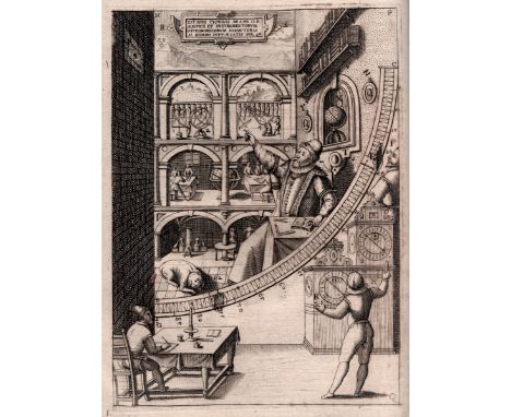
Lot 34
BRAHE (TYCHO)Astronomiae instauratae mechanica, second (first trade) edition, title with large engraved portrait of the author standing beneath an arch containing the arms of the families of Brahe and Bille, 6 large engravings (5 full-page of astronomical instruments, one half-page of the observatory at Hven, Uraniborg), 19 full-page woodcuts (mostly of instruments), and several smaller woodcuts (including a map of the island of Hven), decorative woodcut head- and tailpieces and initials, varying degrees of browning and oxidisation throughout, affecting some illustrations, lower outer corners of first sections curled with slight fraying, title with early ownership inscription crossed through and a few scrawled ?numbers at foot, later stiff wrappers with earlier vellum backstrip titled in ink, soiled, a few short tears and chips and chips to wrappers [Houzeau and Lancaster 2703; Norman 320; Sparrow Milestones 29], folio (320 x 201mm)., Nuremberg, Levinus Hulsius, 1602Footnotes:TYCHO BRAHE'S MOST IMPORTANT ASTRONOMICAL WORK, providing an illustrated description of his astronomical instruments and of the observatory on the island of Hven. The first edition had been printed in 1598 on Brahe's own press at Heinrich Rantzov's castle at Wandbeck, near Hamburg, the forty copies of which Brahe distributed privately. The illustrations of this published 1602 edition were printed from the same blocks and plates, which were sold by the author's heirs to Levinus Hulsius, with the addition of the portrait and the engraving of an armillary sphere on C6 verso, replacing a woodcut. The work also contains a short autobiography and a summary of the principal results of Brahe's observations, and an appendix in which the construction of the observatories is shown.In 1576, King Frederick II had heard of Brahe's plans to move to Basel to further his experiments, he offered Tycho permanent the island of Hven in the Danish Sound to use as he saw fit. There Brahe constructed the most advanced astronomical observatory of his time, which he christened Uraniborg (Heavenly castle)., but hen he realized that the Palladian style towers were not adequate because of the instruments' exposure to the elements and the movement of the building, he constructed a second underground observatory at nearby Stjerneborg, whose basement also housed an alchemical laboratory with 16 furnaces for conducting distillations and other chemical experiments. Unusually for the time, he also established a research centre, where almost 100 students and artisans worked from 1576 to 1597. The library housed Brahe's brass-encased globe, now preserved in Copenhagen: 'On this globe, over the years, Tycho marked the exact positions, referred to the year 1600, of the fixed stars that he observed... In the southwest room on the ground floor at Uraniborg... was Tycho's most famous instrument, the mural quadrant, with a radius of about six feet... Inside the quadrant's arc, for ornamental purposes, was painted a life-size portrait of Tycho seated at a table, with arm outstretched as though pointing to a cylinder...' (DSB).This lot is subject to the following lot symbols: •• Zero rated for VAT, no VAT will be added to the Hammer Price or the Buyer's Premium.For further information on this lot please visit Bonhams.com

Lot 58
BIBLE, IN ENGLISH, AUTHORISED VERSIONThe Holy Bible, Contayning the Old Testamant and the New, titles within wide woodcut illustrated borders, text in 2 columns, Roman type, 2 final leaves of New Nestament shaved at upper margin (part loss to one headline, one fully cropped), 6 leaves with small loss at gutter margin [ESTC S90517; Herbert 431], Robert Barker, and the Assignes of John Bill, 1630; The Genealogies Recorded in the Sacred Scriptures... by J.S., title within woodcut typographical border, double-page map of Canaan (misbound in preliminaries of the Old Testament), lacks pp.31-34 [ESTC S3189], [?F. Kingston, 1630]; The Booke of Common Prayer, woodcut Royal arms on title, title with lower right corner torn away resulting in part loss of one letter, short old paper tab repair [ESTC S93887], Robert Barker, and Assignes of John Bill, 1631; The Booke of Psalmes, woodcut ornament on title [ESTC S90776], Company of Stationers, 1630, 4 works bound in 1 vol., contemporary calf, sides with fine engraved metal corner and centre-pieces, metal straps, clasps and hasps, neatly rebacked in calf gilt, small tear towards fore-edge of lower cover, 4toFootnotes:Provenance: John Lang, of Baconsthorpe, Norfolk, ownership inscription dated 1709/10; Phebe Crane, ownship inscription dated 1 July 1768, both on front free pastedown; inscription dated 1988 on front free endpaper.This lot is subject to the following lot symbols: •• Zero rated for VAT, no VAT will be added to the Hammer Price or the Buyer's Premium.For further information on this lot please visit Bonhams.com
Lot 71
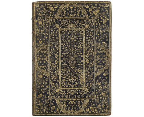
LOGGAN (DAVID)Oxonia illustrata, sive omnium celeberrimæ istius universitatis collegiorum, aularum, bibliothecæ Bodleianæ, scholarum publicarum, Theatri Sheldoniani; nec non urbis totius scenographia, FIRST EDITION, engraved throughout comprising title, privilege, dedication to Charles II, prefatory and index leaves, 40 double-page engraved plates by Loggan including general views of the city, map, and views of the colleges (that of Christ Church double-page and folding), all mounted on guards, some light browning in upper margins, some plates with short slits at foot of fold or guard (a few repaired on verso), in a fine contemporary English binding of black goatskin, tooled with an elaborate all-over design in gilt, sides with outer roll tool borders enclosing double central panel, outer panel with 4 large semi-circles composed of flower, acorn and small semi-circle tools, all panels filled with curling leafy tendrils and numerous different small and large flower tools (including distinctive tulip design in centre), gilt spine with raised bands and 6 of the 8 compartments each containing a floral tool with pointillé and 4 black dots at corners, leather title label, g.e., marbled endpapers, some wear to upper joint and to spine ends and bands, corners slightly bumped [ESTC R5725; Madan 3035], folio (428 x 295mm.), Oxford, E Theatro Sheldoniano, 1675Footnotes:LOGGAN'S 'GREAT WORK' IN A SUMPTUOUS RESTORATION BINDING. The workshop which produced this distinctive binding has not been identified, although some of the tools are redolent of those used by other well-know binders of the period.'David Loggan's great work, including forty large, accurate, and interesting illustrations of Oxford, intended partly as a companion volume to Anthony Wood's Historia et Antiquitates' (Madan). Loggan's largest work, it was produced at Oxford where he held the position of engraver to the university, but despite the Sheldonian imprint, it is thought to have been printed in Loggan's own house in Holywell.Provenance: Charles Finch, 4th Earl of Winchilsea, 4th Viscount Maidstone, 2nd Baron FitzHerbert of Eastwell (1672–1712), bookplate dated 1704 (the year he was appointed Lord Lieutenant and Custos Rotulorum of Kent), and family armorial device mounted on fly-leaf; private UK collection.This lot is subject to the following lot symbols: •• Zero rated for VAT, no VAT will be added to the Hammer Price or the Buyer's Premium.For further information on this lot please visit Bonhams.com

Lot 79
AUSTRALIALEICHARDT (FRIEDRICH WILHELM LUDWIG) Journal of an Overland Expedition in Australia from Moreton Bay to Port Essington, a Distance of Upwards of 3000 Miles, During the Years 1844-1845, edited by Phillip Parker King, 7 mezzotint plates (including frontispiece) after H. Melville and Charles Rodius (one folding, one slightly cropped touching caption), wood-engraved illustrations in the text, additional folding engraved map of 'Stuart's Discoveries in the Continent of Australia from 1858 to 1862' (with routes hand-coloured in outline, some blue wash), without advertisements, some spotting (heaviest on title), and offsetting from plates to text, several pencil annotations and corrections, late nineteenth century half calf, spine gilt in compartments with morocco lettering labels, slightly rubbed [Abbey Travel 579; Ferguson 4571; Wantrup Checklist 138a], 8vo, T. & W. Boone, 1847Footnotes:Leichardt's account of the privately funded expedition of volunteers he led overland from Sydney to Port Essington in the Northern Territories is 'one of the foundation stones of an exploration collection and every collector should acquire a copy' (Wantrup).Provenance: Henry Gerard Sturt, first Baron Alington (1825-1904), armorial bookplate.This lot is subject to the following lot symbols: •• Zero rated for VAT, no VAT will be added to the Hammer Price or the Buyer's Premium.For further information on this lot please visit Bonhams.com
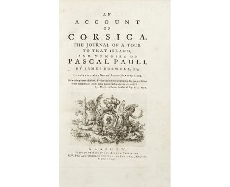
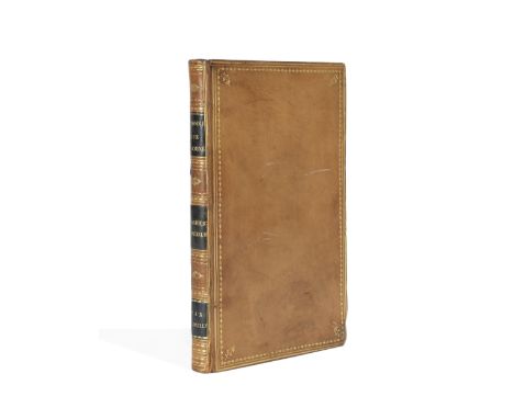
Lot 80
BOSWELL (JAMES)An Account of Corsica. The Journal of a Tour to that Island; And Memoirs of Pascal Paoli, FIRST EDITION, half-title, engraved vignette on title, folding engraved map of Corsica (spotting and off-setting), contemporary tree calf, red morocco gilt spine label, slightly rubbed [Gaskell 473; Rothschild 442], 8vo, Glasgow, Edward and Charles Dilly, 1768Footnotes:Provenance: Hugh Montgomerie, 12th Earl of Eglinton (1739-1819), bookplate. 'In March 1781 Boswell set off for London to appear as counsel for Hugh Montgomerie...' (ODNB) in a matter relating to Montgomerie's contested election as Member of Parliament for Ayrshire. It had been Hugh's uncle Alexander, the 10th Earl, who when Boswell was a young man had diverted his 'thoughts from Catholicism and the priesthood by introducing him into the circles of his high-born and rakish friends, including the young duke of York' (ODNB).This lot is subject to the following lot symbols: •• Zero rated for VAT, no VAT will be added to the Hammer Price or the Buyer's Premium.For further information on this lot please visit Bonhams.com
Lot 81
CHINAD'ANVILLE (JEAN-BAPTISTE BOURGUIGNON) Mémoire... sur les cartes geographiques, insérées dans l'ouvrage compose par le P. DuHalde sur la Chine, woodcut ornament on title [Cordier, Sinica 187; Lust 154; Lowendahl 585], 'A Pe-Kin, et se trouvé a Paris', for the Author, 1776; Considérations générales, sur l'étude et les connaissances que demande la composition des ouvrages de géographie, woodcut ornament on title, E3 possibly a cancellans, Paris, Lambert, 1777, 2 works bound in 1 vol., FIRST EDITIONS, light spotting, contemporary polished calf gilt, marbled edges, pink silk marker, slightly rubbed and scuffed, 8voFootnotes:First editions of two works by the great French cartographer d'Anville, who was engaged by the Jesuits to produce three maps based on the findings of the Jesuit missionaries to China, for inclusion in Pierre Du Halde's Description géographique... de l'Empire de la Chine et de la Tartarie chinoise (1735). These were subsequently revised for the Nouvel atlas de la Chine (1737). In the Mémoire he provided a comprehensive explanation for his methodology in preparing the map, the sources he had chosen to draw from and an overview of earlier expeditions undertaken to China and Tibet.Provenance: Bernard Hanotiau, etched bookplate.This lot is subject to the following lot symbols: •• Zero rated for VAT, no VAT will be added to the Hammer Price or the Buyer's Premium.For further information on this lot please visit Bonhams.com
-
108737 item(s)/page