We found 109198 price guide item(s) matching your search
There are 109198 lots that match your search criteria. Subscribe now to get instant access to the full price guide service.
Click here to subscribe- List
- Grid
-
109198 item(s)/page


Lot 349
JENEFER CAPTAIN (JOHN). A Draft of the Golden & Adjacent Islands, with Part of the Isthmus of Darien as it was taken by Capt. Jenefer where ye Scots West India Company was Settled and A New Map of ye Isthmus of Darien in America, The Bay of Panama ... with its Islands & Countries Adjacent. Pair of engraved maps, cojoined at the fold, each hand coloured in outline. Eng. by Herman Moll & dedicated to Haldane of Gleneagles. 66 x 53cms. John Senex, 1721. For more on the Scots` Expedition to Darien see the following lots and see books lots 102 to 108 et al.

Lot 35
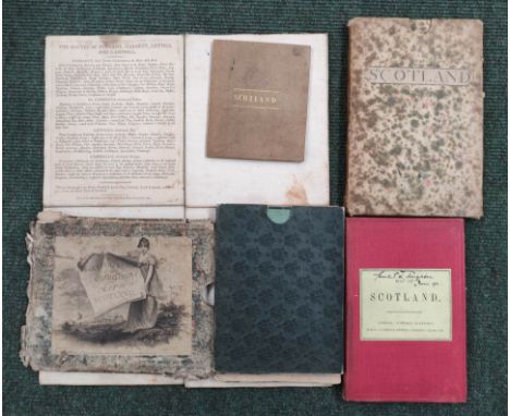
MACPHERSON JOHN. Critical Dissertations on the Origin, Antiquities ... of the Ancient Caledonians. Quarto. Rubbed half calf, lacking front free endpaper, worn. 1768; also 1 other vol. (2).NB. 2 VOLS ONLY IN THIS LOT NOW. THE 3RD VOL ORIGINALLY CATALOGUED IN THIS LOT IS NOW IN LOT 33 TO COMPLETE THE MACCULLOCH SET.One other vol in this lot;MacCulloch, John - A Description Of The Western Islands Of Scotland, 1819, vol. 3. Marbled boards, has monochrome plates (except col. plate 29) with hand coloured maps at back (except monochrome Staffa/St. Kilda). 10 maps in total.Maps1. General map of the Western islands2. Sky, Rasay and adjoining islands3. Rum, Egg and Muck4. Mull and the adjoining islands5. Staffa and St Kilda6. The Slate isles etc.7. Isla, Jura, Colonsa and Oransa.8. Arran and Lamlash9. Bute and Gigha10. The Isle Of Man

Lot 350
JENEFER CAPTAIN (JOHN). A Draft of the Golden & Adjacent Islands, with Part of the Isthmus of Darien as it was taken by Capt. Jenefer where ye Scots West India Company was Settled and A New Map of ye Isthmus of Darien in America, The Bay of Panama ... with its Islands & Countries Adjacent. Pair of engraved maps, each hand coloured in outline. Eng. by Herman Moll & dedicated to Haldane of Gleneagles. Each 31 x 49cms. John Senex, 1721.


Lot 354
THORNTON JOHN. A Large Draught of the Gulf of Darien with the Coast to Porto Bella. Engraved hand coloured map laid or copied on card. The property of the late John Prebble, a version of this was used for the endpapers of his book "The Darien Disaster" (with a letter from Mrs Prebble). 46 x 56cms.


Lot 40
LESLIE JOHN, Bishop of Ross. De Origine Moribus & Rebus Gestis Scotorum. 2 parts, each with title. 11 eng. genealogical plates. Eng. Royal Arms & decs. Without the map called for on the title page (as usual in this edition). Small quarto. Rebound mottled calf. All leaves collated present with Ddd repeated twice & misnumbering to some later pages. 2nd ed., 1675.

Lot 40A
LESLIE JOHN, Bishop of Ross. De Origine Moribus & Rebus Gestis Scotorum. Part 1 only, concluding at James I. 7 eng. genealogical plates. Eng. capitals & decs. No map. Small quarto. Limp vellum, title inscribed to back. All leaves collated present with some misplaced or misnumbered. 1st ed., In Aedibus Populi Romani, Rome, 1578.


Lot 46
ABRAHAM A. P. Rock-Climbing in Skye. 3 copies. Illus. Orig. blue cloth. 1st eds.,1908. Condition report:Maps all present.1 - Foxing and browning as images. No tissue guards.2 - Binding has movement, foxing and browning. Creased map.3 - Cloth damp stained and spine quite faded. Some splitting starting. Foxing and browning. Creased map.All foxed and browned on fore edge and in text. Worn bindings.

Lot 67
KIRKWOOD J. & SONS. Map of Scotland. Hand col. eng. fldg. linen map in well worn orig. slip case. 1804; also 4 other antique fldg. maps of Scotland. (5).Condition report:Kirkwood Map of Scotland - some staining and browning overall. Linen thinning along folds with small hole. Case worn and poor condition.Small map of Scotland by J. dover Pentonville London - Browned, binding discoloured.Stanford Map of Scotland - Faded spine, inscribed label. Browning overall.James Wyld Roads of Scotland - case split and worn. Map slightly browned with light offsetting.Cary's New Sheet Map Scotland - Worn case, map browned with light foxing overall.

Lot 68
AINSLIE JOHN. A Map of Scotland. Large fldg. hand col. eng. map in card slip case. 1838; also 5 small fldg. col. maps ref. Scotland from Lowthian's Ancient & Modern Scotland, in dark morocco slip case & 3 other maps. (5).condition report:Black's large map has anotations/pen marks/roads highlighted, as images.


Lot 61
Speede (John) Cambridgeshire map, described with the division of the hundreds, the Townes situation and also the Armes of the colleges of that famous Universiti... circa 1610 Sudbury and G. Humbell, hand coloured with small plan of Cambridge city, in good overall condition, approx 38.5 x 52.5 cms, framed and glazed. Condition report: as worded, overall in good condition with some general staining near the centre fold.
Lot 112
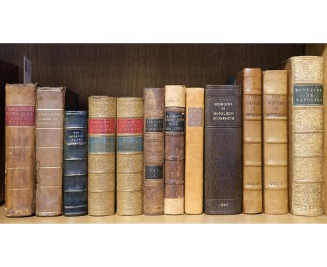
Segur (Phillippe Paul de). History of the Expedition to Russia, undertaken by the Emperor Napoleon, in the year 1812, 2 volumes in 1, 2nd edition, 1825, 7 portrait and plates, folding map, occasional light soiling, a few small repairs, presentation inscription, contemporary half calf, upper joint cracked, edges rubbed, 8vo, together with Goldsmith (Lewis). The Secret History of the Cabinet of Bonaparte, 4th edition, 1810, some light spotting, contemporary half calf, spine repaired and a little wormed, 8vo, plus others related including P.M. Laurent de l'Ardeche's Histoire de l'Empereur Napoleon, Paris, 1840, William Hazlitt's The Life of Napoleon Buonaparte, 2 volumes, 2nd edition, 1852, The History of Napoleon, edited by R.H. Horne, 2 volumes, 1840, and The Napoleon Gallery; or, illustrations of the Life and Times of the Emperor of France, 1837Qty: (12)
![Jesuits. Lettres e?difiantes et curieuses e?crites des missions e?trange?res, [edited by Yves Querbeuf], Nouvelle e?dition, o](https://cdn.globalauctionplatform.com/264540c1-8006-41b4-8705-ad3600d78abc/9f8a0334-6a9b-4171-9f35-ad36010d6c65/468x382.jpg)
Lot 14
Jesuits. Lettres e?difiantes et curieuses e?crites des missions e?trange?res, [edited by Yves Querbeuf], Nouvelle e?dition, orne?e de cinquante belles gravures, 14 volumes, Lyon: J. Vernarel, libraire, E?t. Cabin ..., 1819, 22 folding engraved maps (including Kino's map of California in volume 5), 27 engraved plates & plans (including 15 folding), one folding diagrammatic table, closed tear to single leaf in volume 2 (pp.213/214), some browning & scattered spotting, occasional light damp stains (mostly to volume 7), ex-library with ink stamps to endpapers, early 20th century cloth by Speakman of Liverpool, slight fading to spines, 8voQty: (14)
Lot 16
La Perouse (Jean-Francois Galaup, comte de). The Voyage of La Perouse Round the World, in the Years 1783, 1786, 1787, and 1788, 2 volumes, London: John Stockdale, 1798, engraved portrait frontispiece and 50 engraved maps and plates, one folding map with reinforcement to verso, one or two imprints partly shaved, some offsetting and light spotting, light water stain to volume II frontispiece, contemporary mottled calf, modern calf rebacks, a little rubbed, 8voQty: (2)NOTESFerguson 269; Hill 974; Howes L93; Sabin 38963. One of two English editions published in the same year. The other edition, published by J. Johnson in 3 volumes with less plates, is supposed to have slightly preceded this John Stockdale edition. La Perouse was commissioned by King Louis XVI to expand on Cook's discoveries in the Pacific. "The narrative of the enterprising but ill-fated Perouse, is full of interest in all portions, but his relations of the peculiarities he observed in the natives of the north-west coast of North America, are especially valuable. The mysterious fate of this distinguished navigator has never been satisfactorily cleared up. The above account was transmitted from Botany Bay, after leaving this place the expedition was never heard of again." (Sabin).

Lot 17
Labillardiere (Jaques Julien Houton de). Voyage in search of La Perouse. Performed by Order of the Constituent Assembly, during the Years 1791, 1792, 1793, and 1794, 1st edition in English, 2 volumes in 1, London: John Stockdale, 1800, folding engraved map (discreet reinforcements to verso), 45 engraved plates, a few close-trimmed, some offsetting and spotting, modern calf gilt, 8voQty: (1)NOTESFerguson 309; Sabin 38421. No news had been received for three years from the Comte de la Perouse expedition so a two-ship search and exploration party was organised and set out in 1791. "Proceeding via the Cape of Good Hope to Tasmania, extensive investigations of its coastline were made, New Caledonia, the Solomon Islands, the Admiralty Islands, Tonga, New Britain and other groups were visited, but although most searching inquiries were made, no trace of the missing navigator was found. The crews of the ships suffered greatly from scurvy, and many men were lost from this cause and from the unhealthy climate of Java, where a protracted stay was made. The expedition made several important contributions to geographical knowledge, and the investigations of the naturalists into the productions of countries visited were of special value." (Ferguson).
![Lawrence (T. E.). T.E. Lawrence to his Biographer Robert Graves, [and] T.E. Lawrence to his Biographer Liddell Hart, 2 volume](https://cdn.globalauctionplatform.com/264540c1-8006-41b4-8705-ad3600d78abc/dea67461-7a4a-40bc-bf72-ad36010dc28f/468x382.jpg)
Lot 186
Lawrence (T. E.). T.E. Lawrence to his Biographer Robert Graves, [and] T.E. Lawrence to his Biographer Liddell Hart, 2 volumes, limited edition, London: Faber & Faber, 1938, 2 black & white frontispieces, limitation pages signed by Liddell Hart & Robert Graves, top edges gilt, publishers original cloth in slipcase, spines slightly faded, 8vo, 175/1000 The Letters of T. E. Lawrence of Arabia, edited by David Garnett, 1st edition, London: Jonathan Cape, 1938, black & white folding map & illustrations, previous owner inscription to the front endpaper, minor spotting to the text block, original cloth in dust jacket, covers lightly rubbed, 8vo, The Home Letters of T. E. Lawrence and His Brothers, 1st edition, Oxford: Basil Blackwell, 1954, numerous monochrome illustrations, previous owner inscription to the front endpaper some light toning & marks, some light spotting to the top edge, original cloth in dust jacket, covers lightly rubbed to head & foot, spine lightly toned, 8vo, Seven Pillars of Wisdom, a triumph, 1st trade edition, London: Jonathan Cape, 1935, numerous monochrome illustrations, some minor toning, publishers original gilt decorated brown cloth, spine slightly faded & rubbed to head & foot, together with approximately 20 further modern volumes of T. E. Lawrence reference & related, mostly original cloth in dust jackets, 8voQty: (approximately 25)

Lot 19
Lear (Edward). Journal of a Landscape Painter in Corsica, 1st edition, London: Robert John Bush, 1870, half-title, single-page map and 40 single-page wood-engraved illustrations, numerous wood-engraved illustrations to text, all edges gilt, contemporary gilt-decorated red morocco, lightly rubbed and scuffed to joints and extremities, generally in good condition, large 8voQty: (1)
Lot 201
Alderson (E. A. H.). With The Mounted Infantry and the Mashonaland Field Force 1896, 1st edition, London: Methuen & Co., 1898, 10 monochrome illustrations, minor marginal toning, publishers original gilt decorated blue cloth, spine lightly rubbed to head & foot, 8vo, together with; Spurgin (Karl B.), On Active Service with the Northumberland and Durham Yeomen, Under Lord Methuen (South Africa, 1900-1901.), London: Walter Scott Publishing Co., circa 1902, 15 monochrome illustrations, bookplate to front pastedown, some light spotting & toning, publishers original gilt decorated green cloth, spine slightly rubbed, 8vo, and Williams (Basil), Record of the Cape Mounted Riflemen, 1st edition, London: Sir Joseph Causton & Sons, 1909, 11 colour illustrations plus colour folding map, some spotting throughout, publishers original gilt decorated black cloth, boards & spine rubbed, rear hinge cracked & spine partially detached, 8vo, plus other late 19th-century & modern Boer War reference & related, including South Africa Field Force Casualty List 1899-1902, Essex: Oaklands Books, 1972, some leather bindings, mostly original cloth, some in dust jackets, G/VG, 8vo/4toQty: (3 shelves)
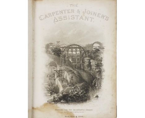
Lot 204
Newlands (James). The Carpenter And Joiners Assistant..., Glasgow: Blackie and Son, 1869, 111 black & white plates plus numerous in-text illustrations, period inscription to front endpaper & verso of the title-page, water damage to foot of front endpaper paper through to plate 1, toning & spotting throughout, pp.291 laid down & strengthened with some minor loss to foot, cracked gutters, contemporary gilt decorated full calf boards & spine rubbed with some minor loss to head & foot, large 8vo, together with; Dugdale (William), Warwickshire; being a Concise Topographical Description of the different Towns and Villages in the County of Warwick, Coventry: printed by John Aston, 1817, 8 black &white engraved plates plus a colour county map, bookplate to front pastedown some light marginal toning, later gilt decorated calf spine retaining contemporary gilt decorated boards, boards lightly marked & rubbed, 8vo, and other 19th & 20th-century miscellaneous history reference, including The Modern Carpenter Joiner and Cabinet-Maker, 8 volumes, by G. Lister Sutcliffe, London: Gresham Publishing, 1903, publishers original uniform green cloth designed by Talyn Morris, large 8vo, some leather bindings, mostly original cloth, some in dust jackets, G/VG, 8vo/4toQty: (6 shelves)

Lot 227
Fawcett (H. W. & G. W. W. Hooper). The Fighting At Jutland, the personal experiences of sixty officers and men of the British Fleet, 1st edition, Glasgow: Maclure, Macdonald & Co., 1920, numerous tipped-in monochrome plates, plus illustrations & maps, top edge gilt, minor toning to the text-block, publishers original gilt decorated quarter blue morocco, boards & spines lightly rubbed, 8vo, together with; Richards (Brooks), Secret Flotillas, the clandestine sea lo NBC es to France and French North Africa 1940-1944, 1st edition, London: HMSO, 1996, inscribed by the author to the half-title, colour & monochrome illustrations plus folding map, original cloth in dust jacket, 8vo, and Hore (Peter), Dreadnought to Daring, 100 years of comment, controversy and debate in The Naval Review, 1st edition, Barnsley: Seaforth, 2012, black & white illustrations, original cloth in dust jacket, plus other modern naval reference, including publications by Australian War Memorial, United States Naval Institute, Conway, Pen & Sword, Airlife, mostly original cloth in dust jackets, some paperback editions, G/VG. 8bo/4toQty: (5 shelves )
Lot 243
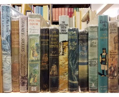
Ardizzone (Edward). Diary of a War Artist, 1st edition, London: The Bodley Head, 1974, numerous monochrome illustrations, original cloth in price-clipped dust jacket, spine lightly faded, 8vo, The Little Bookroom, by Elanor Farjeon, 1st edition, Oxford: University Press, 1955, black & white illustrations, minor marginal toning, original cloth in price-clipped dust jacket, covers slightly rubbed with some loss to the head of the spine & rear cover, 8vo, Showmen and Suckers, by Maurice Gorham, 1st edition, London: Percival Marshall, 1951, black & white illustrations, minor marginal toning, original cloth in dust jacket, sone loss to the head of the spine, 8vo, Open The Door, stories collected & arranged, by Margery Fisher, 1st edition, Leicester: Brockhampton Press, 1965, black & white illustrations, bound-in cloth bookmark, some minor spotting, original cloth in dust jacket, 8vo, together with; Forester (C. S.), Hornblower and the Atropos, 2nd impression before publication, London: Michael Joseph, 1953, some minor toning, original cloth in dust jacket designed by Val Biro, covers lightly rubbed to head & foot, 8vo, and Newman (David), The Forgotten Path, 1st edition, London: Robert Hale, 1965, black & white illustrations plus a map, period inscription to the front endpaper, original cloth in dust jacket designed by Val Biro, spine light rubbed to head & foot, 8vo, plus other modern literature illustrated by Edward Ardizzone & dust jackets illustrated by Val Biro, including 'Portrait Of..' English counties series, 12 volumes, circa 1960s, 8vo, mostly original cloth in dust jackets, G/VG, 8voQty: (3 shelves)
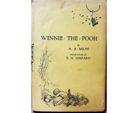
Lot 249
Milne (A. A.). When We Were Very Young, 2nd edition, London: Methuen & Co., December 1924, black & white illustrations by E. H. Shepard, some minor loss to the front pastedown, some minor spotting & toning, top edges gilt, publishers original gilt decorated blue cloth boards & spine slightly rubbed, 8vo, plus a duplicate copy, 4th edition, December 1924, 8vo Winnie-The-Pooh, 5th edition, London: Methuen & Co., 1927, black & white illustrations by E. H. Shepard, map endpapers previous owner inscription to the half-title and showing through to the verso, some minor toning & spotting, top edges gilt, original gilt decorated green cloth in dust jacket, covers slightly toned & rubbed with minor tears to the head, 8vo, together with; Edwards (Amelia B.), A Thousand Miles Up The Nile, 2nd edition, London: George Routledge and Sons, 1891, numerous black & white illustrations, repair to the front pastedown, front & rear gutters cracked, some light toning, contemporary gilt decorated tree calf bound by Bickers & Son, spine rubbed with minor loss, hinges cracked, 8vo, and Edgar (Morton), The Great Pyramid its spiritual symbolism, 1st edition, Glasgow: Bone & Hulley, 1924, colour frontispiece plus monochrome illustrations, some minor spotting to the text-block, publishers original gilt decorated green cloth, boards & spine slightly rubbed, 8vo, plus other late 19th & 20th-century illustrated literature, including Stories Revived, volumes 1 & 3 only, by Henry James, 1st edition, London: Macmillan and Co., 1885, 8vo, some leather bindings, mostly original cloth, some in dust jackets, overall condition is generally good/very good, 8vo/4toQty: (6 shelves )


Lot 255
Asia. Homann (Johann Baptist), Asia secundum legitimas Projectionis Stereographicae..., 1744, engraved map with contemporary outline colouring and some later enhancement to the cartouche and mileage scales, additional title in French above the upper neatline, some dust soiling and staining to the margins, separately printed key plate affixed below the lower neatline which is affected by worming, 505 x 555 mmQty: (1)

Lot 256
Australia. John Power Studios - for Wonder Maps Australia (publisher), The Wonder Map of Melbourne, We show you Melbourne City from a Dizzy height. Come and see it as we know it, you'll vote it very Bright! 1934, bright chromolithographic folding pictorial map, slight wear to old folds, 720 x 960 mm, contained within its contemporary colour pictorial 'envelope style' wrapperQty: (1)NOTESA derivative of Macdonald Gill's 1914 'Wonderground map' of London. and although a pastiche of Gill's work, this has an 'Australian' feel and dimension that stands on its own merit. Uncommon.

Lot 257
* Bedfordshire. Speed (John), Bedford Shire and the Situation of Bedford described with the armes of thos Honorable Familyes that have borne ye titles of Dukes and Earls thereof, George Humble, circa 1627, hand-coloured engraved map, inset town plan of Bedford, large strapwork cartouche and mileage scale, slight creasing and fraying to the central fold, strengthened and repaired on verso, 380 x 510 mm, English text on verso, mounted, framed and double-glazedQty: (1)

Lot 258
Berkshire. Blaeu (Johannes), Bercheria vernacule Bark Shire, Amsterdam, circa 1648, engraved map with contemporary hand colouring, ornate decorative cartouche and two heraldic crests, 385 x 500 mm, French text on verso, together with Bedfordiensis Comitatus Anglis Bedford Shire [on sheet with] Buckinghamiensis Comitatus Anglis Buckingham Shire, Amsterdam, circa 1648, 2 engraved maps with contemporary hand-colouring on one sheet (as published), overall size 420 x 530 mm, French text on versoQty: (2)
![* Berkshire. Speed (John), Barkshire Described, Thomas Bassett & Richard Chiswell [1676], hand-coloured engraved map, pan](https://cdn.globalauctionplatform.com/264540c1-8006-41b4-8705-ad3600d78abc/6c8b28ca-67fe-48d3-b5e1-ad36010df332/468x382.jpg)
Lot 259
* Berkshire. Speed (John), Barkshire Described, Thomas Bassett & Richard Chiswell [1676], hand-coloured engraved map, panorama of Windsor Castle, some spotting and slight staining, central fold partially repaired on verso, 385 x 515 mm, English text on verso, framed and double-glazedQty: (1)

Lot 260
Bermuda. Blaeu (Willem), Mappa aestivarum insularum, alias Barmudas..., Amsterdam, circa 1640, hand-coloured engraved map, large allegorical cartouche, two mileage scales, lists of the tribal names below the map, compass rose and numerous rhumb lines, 405 x 530 mm, French text on versoQty: (1)NOTESBelow the cartouche is a miniature map of Bermuda which shows the correct proportion of the island and its relation and distance from the coast of mainland America. A bright clean example.

Lot 261
Birmingham. Beilby, Knott & Beilby (publishers), To the Right Honourable William Earl of Dartmouth, Viscount Lewisham &c. &c. the Zealous Promoter of the interests of the Town and Liberal Patron of its Public Institutions, This Map of Birmingham engraved from a minute Trigonometrical survey, made in the years 1824 & 1825, is with permission dedicated..., Birmingham, March 25th 1828, uncoloured engraved map, sectionalised and laid on linen, inset plan of the town of Birmingham in the year 1731, large calligraphic cartouche, compass rose and mileage scale, some staining, edged in green silk, 1380 x 1290 mm, marbled endpapers, contained in a contemporary calf book box, worn and frayedQty: (1)NOTESRare. Copac lists only four known copies.

Lot 264
British Isles. Homann (Johann Baptist, heirs of), Regnorum Magnae Britanniae et Hiberniae Mappa Geographica..., Nuremberg, 1749, engraved map with contemporary hand colouring, additional title in English above the map, inset map of the Shetland Islands, large uncoloured allegorical cartouche, slight staining and dust soiling, 490 x 555 mm, together with Homann (Johann Baptist). Magnae Britanniae pars Meridionalis in qua Regnum Angliae tam in septem antiqua Anglo Saxonum Regna..., Nuremberg, circa 1720, engraved map with contemporary hand-colouring and some later enhancement to the cartouche and vignette, slight creasing, slight staining, but largely confined to the margins, 575 x 490 mm, with Philippe (Pierre). Les Isles Britanniques comprenant L'Angleterre, L'Ecosse et L'Irlande, circa 1750, hand-coloured map engraved by J. Vallet, large compass rose and decorative cartouche, 280 x 405 mmQty: (3)


Lot 267
* Caernarvonshire. Speed (John), Caernarvon both Shyre and Shire-Towne with the ancient Citie Bangor described, Thomas Bassett & Richard Chiswell [1676], hand-coloured engraved map, inset town plans of Caernarvon and Bangor, large strapwork cartouche and mileage scale, 385 x 510 mm, mounted, framed and glazed, together with Blaeu (Johannes). Comitatus Nottinghamiensis, Nottingham Shire, Amsterdam, circa 1648, engraved map with contemporary hand-colouring, slight overall toning, slight mount staining, 390 x 500 mm, Latin text on versoQty: (2)
![Cambridge, Bedford & Huntingdonshire. Drayton (Michael). Two allegorical maps, [1622], two hand-coloured engraved allegor](https://cdn.globalauctionplatform.com/264540c1-8006-41b4-8705-ad3600d78abc/457bff9c-da63-4421-b5ec-ad36010df881/468x382.jpg)
Lot 268
Cambridge, Bedford & Huntingdonshire. Drayton (Michael). Two allegorical maps, [1622], two hand-coloured engraved allegorical maps, the first centred around the Isle of Ely, the second showing parts of Cambridge, Bedfordshire and Huntingdonshire, slight staining to the second map, each approximately 240 x 310 mmQty: (2)NOTESPublished in the 2nd edition of the Poly-Olbion
Lot 269
Camden (William). Britannia: or a Chorographical Description of Great Britain and Ireland, together with the Adjacent islands..., revised by Edmund Gibson, 2 volumes, 2nd edition, circa 1730, engraved portrait frontispiece, title printed in red & black, 10 plates of coins and antiquities, 10 (only) uncoloured engraved double-page maps (Bedfordshire, Huntingdonshire, Northamptonshire, Shropshire, Staffordshire, Nottinghamshire, Rutland, Leicestershire, Hereford and Monmouth), slight spotting throughout, bookplates of J. B. Boulton & Peter Delme, contemporary mottled calf, upper board on volume 1 detached and on volume 2 near detached, rubbed and worn, folio, together with Johnston (Alexander Keith). Handy Royal Atlas of Modern Geography, 1881, numerous double-page colour lithographic maps, slight spotting, contemporary half morocco gilt, rubbed and worn, folio, with Dugdale (Thomas). England and Wales Delineated..., volumes 2, 3 & 4 (only), circa 1840, decorative titles, 21 uncoloured engraved portraits, 157 engraved topographical views and 45 uncoloured engraved county maps by J. Archer, occasional offsetting, contemporary half morocco gilt, slight wear to extremities, 8vo, plus Lewis (Samuel). A Topographical Dictionary of England..., 4 volumes, together with the Atlas volume, 1831, the atlas volume comprising of an uncoloured engraved folding map of England and Wales and 42 uncoloured engraved maps by Thomas Starling (including 13 folding), lacking the plan of London, contemporary half morocco gilt, worn at extremities, 4to, with 11 other atlases similar, including examples by Bacon, Letts, Vertue & Co and part of a later Camden atlas containing the map and description of Lincolnshire, including a folding engraved map by John CaryQty: (22)NOTESSold as a collection of maps and plates, not subject to return.

![Cumberland & Westmorland. Drayton (Michael), Untitled allegorical map, [1622], hand-coloured engraved allegorical map, sl](https://cdn.globalauctionplatform.com/264540c1-8006-41b4-8705-ad3600d78abc/16b8d00b-4ddd-464a-90a8-ad36010df9fd/468x382.jpg)
Lot 271
Cumberland & Westmorland. Drayton (Michael), Untitled allegorical map, [1622], hand-coloured engraved allegorical map, slight mount staining, very slight worming, 245 x 310 mmQty: (1)NOTESPublished in the 'expanded' 2nd edition of the 'Poly-Olbion'. The map is not present in the earlier 1612 edition.

Lot 272
Derbyshire. Blaeu (Johannes), Darbiensis Comitatus vernacule Darbie Shire, Amsterdam, 1646, engraved map with contemporary hand-colouring, large decorative cartouche and mileage scale, 385 x 495 mm, Latin text on verso, together with Comitatus Nottinghamiensis; Nottingham Shire, Amsterdam, circa 1648, engraved map with contemporary hand-colouring, 385 x 490 mm, French text on versoQty: (2)
![Derbyshire. Speed (John), Anno Darbieshire described, John Sudbury & George Humble [1616], hand-coloured engraved map, an](https://cdn.globalauctionplatform.com/264540c1-8006-41b4-8705-ad3600d78abc/01ea2d79-7058-4b9b-af29-ad36010dfb5a/468x382.jpg)
Lot 273
Derbyshire. Speed (John), Anno Darbieshire described, John Sudbury & George Humble [1616], hand-coloured engraved map, an inset town plan of Derby and a vignette of Buxton, large strapwork cartouche and compass rose, trimmed to neatline with margins extended, a repaired hole at the base of the central fold, slight overall toning, 385 x 515 mm, Latin text on verso, together with The West Ridinge of Yorkshyre with the most famous and fayre Citie Yorke described, John Sudbury & George Humble, circa 1627, hand-coloured engraved map, an inset town plan of York, some creasing, 380 x 505 mm, English text on versoQty: (2)
![* Eastern Europe. Wells (Edward), A New Map of Present Poland, Hungary, Walachia, Modavia, Little Tartary &c. [and] A New](https://cdn.globalauctionplatform.com/264540c1-8006-41b4-8705-ad3600d78abc/810fa750-4e86-4439-acd4-ad36010dfce4/468x382.jpg)
Lot 275
* Eastern Europe. Wells (Edward), A New Map of Present Poland, Hungary, Walachia, Modavia, Little Tartary &c. [and] A New Map of Sarmatia, Europaea, Pannonia and Dacia..., circa 1700, two hand-coloured engraved maps, each with an elaborate strapwork cartouche and mileage scale, each approximately 365 x 500 mm, uniformly mounted, framed and glazedQty: (2)
![* England & Wales. Speed (John), The Kingdome of England, published Thomas Bassett & Richard Chiswell, [1676], engrav](https://cdn.globalauctionplatform.com/264540c1-8006-41b4-8705-ad3600d78abc/03143fde-7bdc-42c1-8150-ad36010dfd87/468x382.jpg)
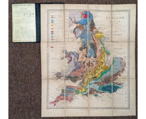
Lot 278
England & Wales. Geological Map of England and Wales (with all the Railways), by Roderick Impey Murchison, 5th edition, 1864, folding engraved map by J. & C. Walker, with original hand-colouring, sectionalised on linen, light dust-soiling & toning, slight spotting, contained within original green cloth covers, 153 x 100mm, map dimensions approx. 385 x 320mmQty: (1)

Lot 279
England & Wales. Homann (Johann Baptist), Magnae Britanniae pars Meridionalis in qua Regnum Angliae tam in Septem Antiqua Anglo-Saxonum Regna..., Nuremberg, circa 1720, engraved map with contemporary hand-colouring, margins stained and dust-soiled, very slight spotting, 580 x 490 mm, together with Ogilby (John). A New Map of the Kingdom of England & Dominion of Wales whereon are Projected all ye Principal Roads, Actually Measured & Delineated by John Ogilby Esq. [1675 - 76], hand-coloured engraved map, slight dust-soiling, short split at the base of the central fold, 380 x 500 mm, with Cary (John). A New Map of England from the Latest Authorities, 1807, engraved map with contemporary hand-colouring, some creasing and dust soiling, 460 x 520 mmQty: (3)

![* Europe. Schedel (Hartmann) Untitled map of Northern & Central Europe, Nurnberg [1493], uncoloured woodcut map engraved](https://cdn.globalauctionplatform.com/264540c1-8006-41b4-8705-ad3600d78abc/35a194df-e20e-456e-aea4-ad36010e00c6/468x382.jpg)
Lot 282
* Europe. Schedel (Hartmann) Untitled map of Northern & Central Europe, Nurnberg [1493], uncoloured woodcut map engraved by Hieronymous Munzer and published in the 'Nurnberg Chronicle', some restoration and strengthening of the central fold, 390 x 580 mm, mounted, framed and glazedQty: (1)NOTESThe map is one of the earliest depictions of Europe, extending to Russia in the east and Ireland in the west. In the south, the map extends south of the Alps to Istanbul, Venice and the northernmost coast of the Mediterranean Sea and up to Scandanavia in the north. Schedel's map is a cartographic landmark, widely regarded as being the earliest obtainable map of Central Europe available to collectors.

Lot 286
Fullarton (Archibald & Co. publisher). The Royal Illustrated Atlas of Modern Geography, Introductory Notice by Dr N. Shaw, London & Edinburgh, circa 1862, engraved pictorial title, 76 colour printed single and double-page engraved maps, a few maps with closed tears affecting the printed image, some water staining and spotting throughout, one map detached, printed ink ownership stamp to contents list and the margin of two maps, upper hinge broken, all edges gilt, contemporary half morocco gilt, heavily worn and stained, folio, together with Bacon (George W. publisher). New Complete Atlas of the World, circa 1900, title and preface, 124 (complete as list) colour printed maps, a few maps detached with subsequent fraying to the foredge, slight finger and dust soiling, contemporary half calf gilt, lacking spine, heavily worn and frayed, folioQty: (2)NOTESSold as a collection of maps, not subject to return.
-
109198 item(s)/page