We found 109198 price guide item(s) matching your search
There are 109198 lots that match your search criteria. Subscribe now to get instant access to the full price guide service.
Click here to subscribe- List
- Grid
-
109198 item(s)/page
![ROBERT MORDEN: STAFFORD SHIRE, engraved hand coloured map [1695], approx 430 x 365mm, framed and glazed](https://cdn.globalauctionplatform.com/e9790c41-c947-402e-ad16-adbb00e6d97a/06f06e0c-1af3-4c76-9909-adc0011c6e62/468x382.jpg)


Lot 144
OWEN/BOWEN, 2 hand coloured engraved road maps, 1736, printed recto and verso, comprising THE ROAD FROM YORK TO WHITBY AND SCARBOROUGH, inset map of Westmorland, pages 269-272 + THOMAS GARDNER: THE ROAD FROM MONMOUTH TO LLANBEDR, engraved hand coloured road map circa 1719, sheet 77, approx 170 x 260mm, framed and glazed + THOMAS GARDNER: THE CONTINUATION OF THE EXTENDED ROAD... BARNSLEY TO RICHMOND, engraved hand coloured road map circa 1719, sheet 49, approx 170 x 260mm (4)


Lot 146
OWEN/BOWEN: 3 hand coloured engraved road maps circa 1736, printed recto and verso, comprising THE ROAD FROM BRISTOL TO WESTCHESTER..., inset map of Herefordshire, pages 143-146, double glazed frame; THE ROAD FROM HUNTINGDON TO IPSWICH..., inset map of Huntingdonshire, pages 193-194 double glazed frame + JOHN OGILBY: THE CONTINUATION ROAD FROM LONDON TO HOLY HEAD, engraved hand coloured road map circa 1698, plate 23, very browned, approx 310 x 430mm, framed and glazed (3)


![ROBERT MORDEN: THE EAST RIDING OF YORKSHIRE, engraved hand coloured map [1695], browned, approx 355 x 420mm, framed and glaze](https://cdn.globalauctionplatform.com/e9790c41-c947-402e-ad16-adbb00e6d97a/cbcf0a09-5ad3-4dbf-9a40-adc0011c7472/468x382.jpg)

Lot 158
SOCIETY FOR THE DIFFUSION OF USEFUL KNOWLEDGE: EIGHT ENGRAVED PART HAND COLOURED ITALY TOWN PLANS COMPRISING TURIN, London, George Cox, 1853, approx 300 x 375mm, FLORENCE, London, George Cox, 1852, approx 285 x 370mm, MILAN, London, George Cox, 1852, approx 350 x 380mm, NAPLES, London, George Cox, 1853, approx 320 x 375mm, VENICE, London, George Cox, 1853, 2 plans West and East, approx 375 x 290mm, MODERN ROME AND ANCIENT ROME, 2 plans, London, George Cox, 1853, approx 295 x 375mm, together with SYRACUSE, engraved part hand coloured map, London, George Cox, 1853, approx 320 x 390mm (9)
![JOHN SPEED: NORFOLK..., engraved hand coloured map [1627], approx 375 x 505mm, double glazed](https://cdn.globalauctionplatform.com/e9790c41-c947-402e-ad16-adbb00e6d97a/fec93dd8-43d2-4079-b412-adc0011c7cf7/468x382.jpg)
![JOHN SPEED: THE COUNTYE PALATINE OF CHESTER..., engraved part hand coloured map [1676], approx 380 x 505mm, framed and glazed](https://cdn.globalauctionplatform.com/e9790c41-c947-402e-ad16-adbb00e6d97a/91a5a824-0ee3-47b4-9320-adc0011c7ddd/468x382.jpg)
![CHRISTOPHER SAXTON/WILLIAM KIP: NORFOLCIAE COMITATUS..., engraved hand coloured map [1637], approx 265 x 380mm, framed and gl](https://cdn.globalauctionplatform.com/e9790c41-c947-402e-ad16-adbb00e6d97a/3d430e88-b5be-474b-aef7-adc0011c8052/468x382.jpg)
Lot 77
Latvia, mint and used stamp collection, mainly 1918-41 in a Lighthouse stock book with a good degree of specialisation and some high value sets etc, 1918 map stamp, 5K red including full sheet of 228 (map R15) in a double glazed frame (glass cracked) plus various on stock leaves and a packet loose together with various relevant reference material in a ring binder


Lot 276
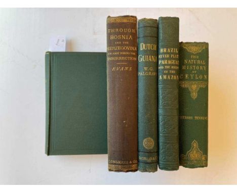
Travel. CUNNINGHAM (Robert O) Notes on the Natural History of the Strait of Magellan and West Coast of Patagonia, made during the Voyage of H.M.S. 'Nassau' in the years 1866, 67, 68, & 69, 1st edition, Edinburgh, 1871, folding map (partial tear along a fold), lithograph plates including tinted views, as required, some spotting and foxing, original green cloth gilt; PALGRAVE (W G) Dutch Guiana, 1876, 1st edition, 8vo, folding colour map and folding plan, half-title, scattered light foxing, original cloth; EVANS (Arthur J) Through Bosnia and Herzegóvina on Foot, 1st edition, 1876, 8vo, frontispiece, folding map, illustrations, 40pp. advertisements at end, original cloth gilt, contemporary owner's engraved bookplate; HADFIELD (William) Brazil, the River Plate, and the Falkland Islands, 1st edition, 1854, 8vo, lithograph portrait frontispiece, large folding coloured map, map of the Falkland Islands, wood-engraved plates and illustrations, cracked endpapers, original blindstamped cloth; TENNENT (Sir J E) Sketches of the Natural History of Ceylon, 1861, 8vo, illustrated, original cloth (5)

![CULPEPER (N) English Physician and Complete Herbal, [1794], 4to, engraved frontispiece and plates, somewhat age toned and soi](https://cdn.globalauctionplatform.com/fecba2e8-f417-4853-8544-adb000d3ce28/88b4d727-0b5f-4ba5-ad8f-adb80103d7d9/468x382.jpg)
Lot 62
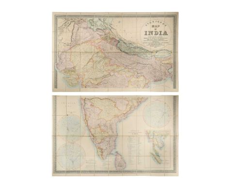
INDIA. STANFORD (Edward) Stanford's Map of India, based on the surveys executed by order of the Honourable The East India Company, 1857, in two sections, North and South, a large-scale lithographic map on two sheets with hand colour, circular cartouche title, the South section with inset map of the Malay Peninsula and three diagrams illustrating 'Distances and Bearings from Bombay', and similarly 'Madras' and 'Calcutta', each section approx. 825 x 1280 mm, dissected and mounted on linen, some spotting and minor surface dirt, folding into a rubbed slipcase

![ELLIS (Rev. W) Three Visits to Madagascar, 4th thousand 1858, 8vo, map and illustrations, original cloth; [BLENKINSOP] A Tran](https://cdn.globalauctionplatform.com/fecba2e8-f417-4853-8544-adb000d3ce28/106207d4-a79a-4b76-96f3-adb801045a3f/468x382.jpg)
Lot 253
ELLIS (Rev. W) Three Visits to Madagascar, 4th thousand 1858, 8vo, map and illustrations, original cloth; [BLENKINSOP] A Transport Voyage to the Mauritius and Back, John Murray 1851, small 8vo, half calf; SAYER (Captain) The History of Gibraltar, 1862, 8vo, tinted frontispiece and two plates, folding map, cloth; MANN (J H) A History of Gibraltar and its Sieges, 2nd edition, 1873, 8vo, mounted photographs and a map as called for, some foxing, original cloth (damp stained)
Lot 170
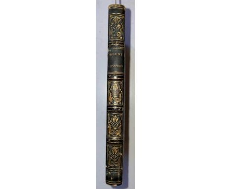
HAMILTON (Sir W) Observations on Mount Vesuvius, Mount Etna, and other Volcanos: In a series of letters, addressed to the Royal Society, 2nd edition London 1773, 12mo, 5 engraved plates (all cropped to one side margin) and folding engraved map, a little foxed and toned, 19th century calf backed boards

Lot 191
CHAUNCY (Sir Henry) The Historical Antiquities of Hertfordshire, in 2 vols. 1826, 8vo, folding map and plates as required, variable foxing and spotting throughout, calf, rubbed edges; WALPOOLE (George A) The New British Traveller. London: for Alex Hogg, no date c.1800, folio, frontispiece damaged, lacking general map and 7 other plates of maps, 14 map plates only present including Cross Roads, (Scotland map damaged), numerous plates of views, subscribers list incomplete, stains and faults, binding worn (3)

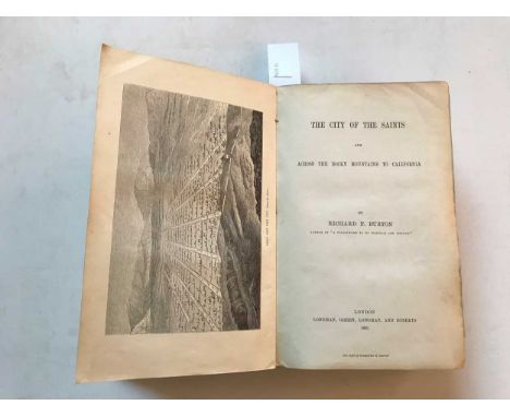
Lot 251
The City of the Saints and Across the Rocky Mountains to California, first edition, London 1861, 8vo, half-title, folding map, plates, as required, front inner hinge broken, publisher's green cloth with beehive motif, spine creased, a little shaken, front board with signs of a removed label, Mudie label to rear paste-down

Lot 66
Johannes JanssoniusPolus Antarcticus, hand-coloured double-page engraved map of the South Polar region circa 1640, in a hemispherical projection with decorative figural spandrels, French text verso, generally toned, a few spots and flies, some creasing around the centre fold, lower centrefold with a partial split

Lot 260
JAMES (F L) The Unknown Horn of Africa. London 1888, 8vo., no. 16 of 21 copies on Japanese vellum, plates and illustrations including 10 hand-coloured lithographed plates with duplicates in monochrome, 9 unnumbered tinted plates with duplicates, colour folding map in pocket, 4 plates at end, printed limp wrappersCondition report: good appearance internally; cover with some general wear to the edges

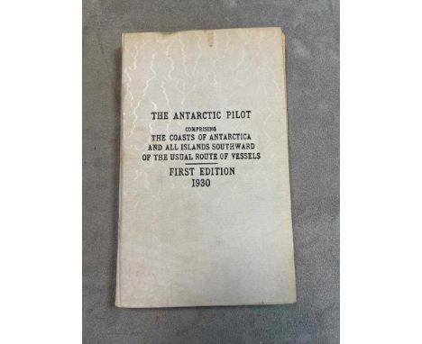
Lot 362
THE ANTARCTIC PILOT, comprising the Coasts of Antarctica and all Islands Southward of the Usual Route of Vessels. London: The Hydrographic Department, Admiralty, 1939, 8vo, cream cloth covers marked 'First Edition 1930', with pink paper 'Notice' leaf before title, 3 maps including 2 folding, illustrations (some printed back to back), with Supplement No. 11-1944 booklet inserted; GUNTHER (E R) Notes and Sketches made during two years on the 'Discovery' Expedition, Oxford 1928, 4to, paper wrappers (dust stained), author's inscribed compliments slip inserted; Scottish National Antarctic Expedition, Report on the Scientific Results of S.Y. "Scotia". Vol. IV - Zoology, 1908, 4to, maps and plates, original cloth; PEARY (R E) Nearest the Pole, London 1907, large 8vo, large folding map, illustrations, bookplate of Leonard Harrison Matthews, blue cloth gilt (4)
Lot 160
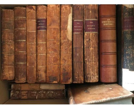
GODWIN (William) Enquiry Concerning Political Justice, 2nd edition in 2 vols. 1796, 8vo, light spotting, calf, worn; SMITH (Adam) An Inquiry into the Nature and Causes of the Wealth of Nations, 7th edition, vols. I and III only, London 1793, 8vo, very rubbed; PRIESTLEY (J) Institutes of Natural and Revealed Religion, 2nd edition, in 2 vols., Birmingham 1782, 8vo, tree calf, rubbed; DARWIN (E) The Botanic Garden, 2 vols., 4th edition 1799, 8vo, plates, some staining, worn calf; GOGUET (A Y) The Origin of Laws, Arts, and Sciences and their Progress among the most Ancient Nations, in 3 vols. Edinburgh 1775, 8vo, plates, worn calf; An Universal History, vol. V only 1747, 8vo, folding map and plates, 20th century half morocco; MILLAR (J) Observations concerning the Distinction of Ranks in Society, 2nd edition, 1773, 8vo, worn calf; 10 others, mainly odd volumes in worn bindings (23)

Lot 366
Prize bindings. BENNETT (A W) The Flora of the Alps, 2 vols. 1900, small 8vo, many coloured plates; ROBERTS (Lord) Forty-One Years in India, 1901, new edition, 8vo, folding map, plans, and portraits, green calf gilt; 11 others mainly history and science; also - two 18th century hand coloured engraved maps: Essex by Thomas Kitchin, 20.5 x 26cm; and Warwickshire by Owen and Bowen, 19 x 12.5cm (16)

Lot 288
Scotland and Northern Europe, travel and topography. ST JOHN (Charles) A Tour in Sutherlandshire, 2nd editon in 2 vols., 1849, 8vo, plates, original cloth; WELD (C R) Two Months in the Highlands, Orcadia and Skye, 1860, 8vo, coloured lithographic plates, illustrations, original cloth; KNIGHT (W) Through the Wordsworth Country, illustrated by Harry Goodwin, 1887, 4to, plates, bright cloth gilt; WARNER (Richard) A Tour through the Northern Counties of England and The Borders of Scotland, 2 vols. in one, Bath 1802, 8vo, tinted aquatint frontispieces, a little toned throughout, half calf; TOMLINSON (C) Winter in the Arctic Regions, no date, circa 1872, 8vo, 2 folding maps, illustrations, green cloth; RAE (E) The Land of the North Wind, John Murray 1875, 8vo, folding map, plates, as required, small tear to title, half calf (upper board detached); few others (18)
Lot 421
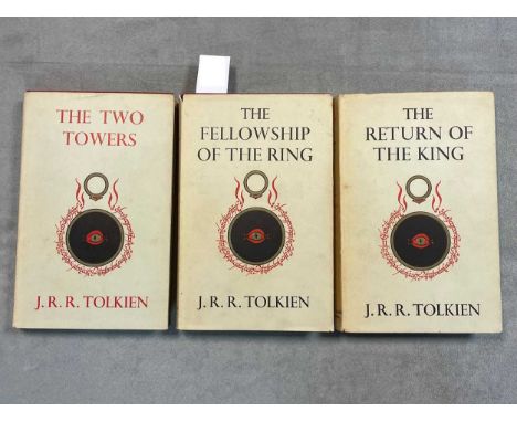
TOLKIEN (J R R) The Lord of the Rings, 3 vols., 9th impression (The Two Towers, The Return of the King) and 10th impression (The Fellowship), 1961-62, 8vo, folding map at end of each, no inscriptions, original red cloth, dust jackets generally good with light wear, one price neatly clipped (3)Condition report: images are attached.
Lot 60
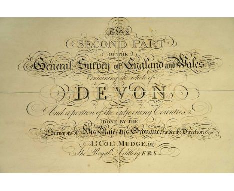
Devon. MUDGE (Lt. Col. William) The Second Part of the General Survey of England and Wales Containing the Whole of Devon and a Portion of the Adjoining Counties, no date, title sheet and eight large scale engraved map sheets, each section approx. 625 x 950 mm, dissected and linen backed, slight surface staining and offsetting, in original red morocco box with gilt Ordnance shield crest (slightly rubbed)
Lot 290
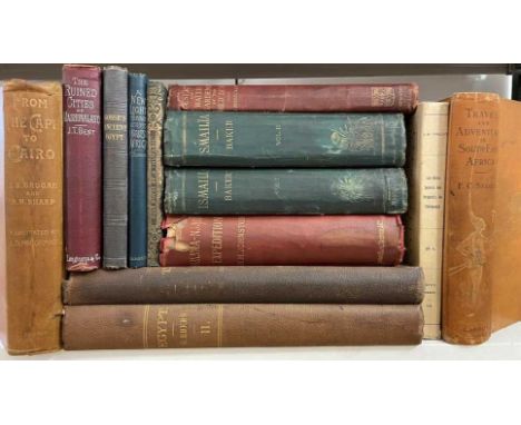
Africa. EBERS (G) Egypt: Descriptive, Historical, and Picturesque, 2 vol., Cassell & Co 1887, 4to, plates and illustrations, faded plain cloth; BAKER (Sir Samuel) Ismailia, in 2 vols. 1874, 8vo, maps, portraits and plates, ex. library, a little shaken and worn; JOHNSTON (H H) The Kilima-Njaro Expedition, 1886, 8vo, maps and illustrations, rear hinge weak, portrait slightly foxed, original cloth with spine chipped at head with loss; SELOUS (F C) Travel and Adventure in South East Africa, 1893, 8vo, folding map, illustrations, original cloth gilt, stained and worn in places; GROGAN & SHARP. From the Cape to Cairo, 1900, 8vo, maps and plates, light foxing, a little shaken, original cloth, spine worn; 6 others, 8vo and 12mo, (13)

Lot 57
KNIPE (J A) Geological Map of Scotland, Lochs, Mountains, Islands, Rivers and Canals. The Railways and Principal Roads, and Sites of the Minerals, by J. A. Knipe. Author of the Geological Map of the British Isles, Inscribed to H.R.H. Prince Albert. London, Edward Stanford 1858. Folding lithographic hand coloured dissected map, linen backed, 1097 x 844mm, lacking slip case.Condition report: Apparently a first edition of this rare map. Reference: Toland, Ryder & Torrens. 'The Life and Works of James Alexander Knipe (?1803-1882), British Itinerant Geological Map Maker', Earth Science History, vol. 32, No. 2, 2013.

Lot 235
West Indies - travel. FROUDE (James Anthony) The English in the West Indies, 1888, 8vo, wood-engraved title-vignette and 8 plates (marginal browning), publishers' catalogue at end, later cloth; COLERIDGE (H E) Six Months in the West Indies in 1825, 3rd edition, 12mo, folding map slightly stained on to title, 'Family Library' cloth binding; KINGSLEY (C) At last, a Christmas in the West Indies, 4th edition 1874, 8vo, original cloth; also - PRIOR (James) Narrative of a Voyage in the Indian Seas in the Nisus Frigate during the Years 1810 and 1811, no date [circa 1820], 8vo, folding chart frontispiece and 3 plates as required, 112pp., paper wrapper; others including natural history (10)

Lot 215
HUC (E R) Travels in Tartary, Thibet, and China during the years 1844-5-6, translated from the French by W. Hazlitt, no date (circa 1851), 2 vols., 8vo, National Illustrated Library edition, folding map, added engraved titles, frontispieces and illustrations, original cloth gilt spines; WILKES (C) Narrative of the United States Exploring Expedition, 2 vols., 1852, 8vo, in uniform original cloth (4)


Lot 277
Travels and voyages. BAIKIE (William Balfour) Narrative of an Exploring Voyage up the Rivers Kwo'ra and Bi'nue, (commonly known as the Niger and the Tsadda) in 1854. London: John Murray, 1856, 1st edition, 8vo, folding engraved map, folding plan (partial tear to a fold), frontispiece, contemporary half calf, repaired; [SCOTT (Michael)] The Cruise of the Midge, 1st edition, 2 vols. 1836, 12mo, half titles, lightly toned, plain original cloth; BURNEY (William) The British Neptune ... Achievements of the Royal Navy, London 1807, small 8vo, folding map and 8 plates as called for, all rather age stained, map reinforced and soiled, morocco, recased and rebacked; ALCOCK (A) A Naturalist in Indian Seas, London: John Murray, 1902, 8vo, folding map (foxed), plates, sporadic spotting, original cloth; few others early 20th century, cloth (22)


Lot 271
BURTON (Richard F) Vikram and the Vampire or Tales of Hindu Devilry. London 1870, 8vo, illustrated by Ernest Griset, half title, frontispiece and plates, original green cloth gilt; The Lands of Cazembe. Lacerda's Journey to Cazembe in 1798. John Murray 1873, 8vo, large folding coloured map, original blue cloth, gitl lettered spine; A Sketch of the Career of ---, by A B Richards, A Wilson and St Clair Baddeley, 1886, small 8vo; WRIGHT (T) Life of Burton, 2 vols. 1906, cloth, (rather shaken): The Jew, the Gypsy and El Islam, 1898, cloth (rubbed); STISTED (Georgiana) The True Life of Captain Sir R F Burton, 1896, 8vo, original cloth (7)

Lot 225
HOARE (Richard Colt) The Itinerary of Archbishop Baldwin Through Wales, A.D. MCLXXXVIII, by Giraldus De Barri, 2 vols., London: W. Miller 1806, 4to, large folding hand coloured map, plates as called for, uncut, slight foxing and offsetting, boards (rubbed); DONOVAN (E) Descriptive Excursions through South Wales and Monmouthshire, 2 vols., 1805, 8vo, half calf; WILLIS (Browne) A Survey of the Cathedral Church of Landaff, 1719, 8vo, folding plan and plate, contemporary sprinkled calf; BRIDGEMAN (G T O) History of the Prines of South Wales, 1876, author's letter pasted in, front hinge broken, cloth; 3 others (9)
Lot 289
Travel including Asia and Americas. BURNABY (F) A Ride to Khiva, 9th edition 1877, 8vo, 3 folding maps, original cloth (stained); THURSTON (Edgar) Ethnographic Notes in Southern India. Madras 1906, 8vo, plates, original cloth, a little faded; COCKBURN (John) A Journey over Land.., London 1735, 8vo, lacking folding map, some light foxing, calf, rebacked; PATON (A A) Highlands and Islands of the Adriatic, in 2 vols. 1849, folding map, plates, light foxing, faded original cloth; WHYMPER (Edward) Travels Amongst the Great Andes of the Equator, 1892, 8vo, with 'Special Edition Subscriber's copy No. 16 Edward Whymper' leaf to face half title, numerous illustrations but lacking the accompanying separate map vol. ; Supplementary Index vol. of natural history specimens, 1891, both vols. in calf backed boards (scuffed); various others (20)

Lot 122
PROCLUS (Diadochus) De sphaera; CLEOMEDES, libri I & II; ARATI; DIONYSII; HONTERI; Basel: per Henricum Petri, 1561, small 8vo, circa 154 x 107mm, text in Latin and Greek, De Sphaera with wood engravings of Proclus teaching and an armillary sphere, and 12 further spherical diagrams; Honteri Cosmography section with 10 double page maps and 10 single page maps only, including World map, Britain, Spain, France, Italy, Germany, Greece, India and Africa, (pp.933-940 missing), final soiled leaf with printer' device; some damp and age staining, damaged binding with 1 board only; incomplete. Sold not subject to return.

Lot 134
VERGILIUS MARO (P) Opera, Leiden: Elzevir 1636, 12mo, with engraved title and folding map, red ruled throughout, contemporary red morocco gilt, rubbed; [De LAET (Joannes)] Portugallia sive Regis, Elzevir: Leiden, 1641, 16mo, engraved title, damp-stain mark to first few leaves, contemporary binding; and two others - poetry, early 19th century, calf, rubbed (4)


![Two maps of Cumberland, including John Oglsby's strip map depicting "The Roads from Kendal [...] to Carlisle", 40 x 49cms, fr](https://cdn.globalauctionplatform.com/cdd474b9-4c54-4455-870e-ad7200b1ed34/8d74278a-3312-462b-8a8b-adbf00bebc11/468x382.jpg)


Lot 631
A pair of gilt framed and glazed (later) hand-coloured map engravings; 'The Continuation of the Extended Road from Oakham in Rutland to Richmond Com Ebor', together with companion engraving 'The Road from Ferrybridge to Borough Bridge continued to Barnard Castle In Com Ebor' (the slightly larger 36.5cm x 45cm) (2)


-
109198 item(s)/page