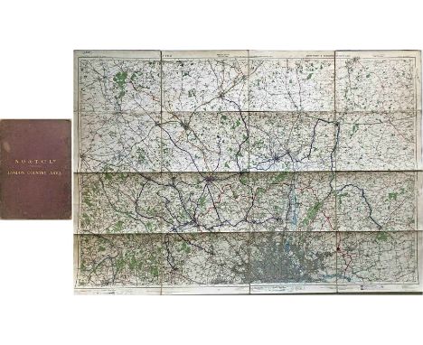
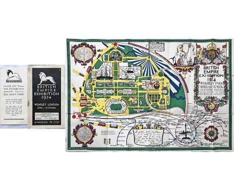
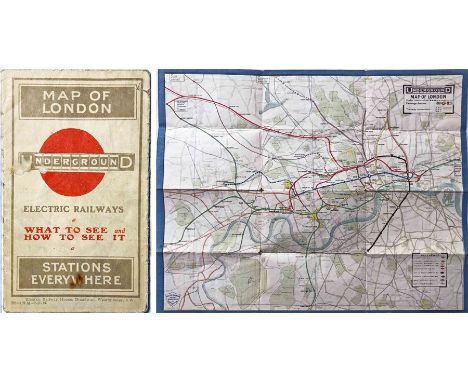
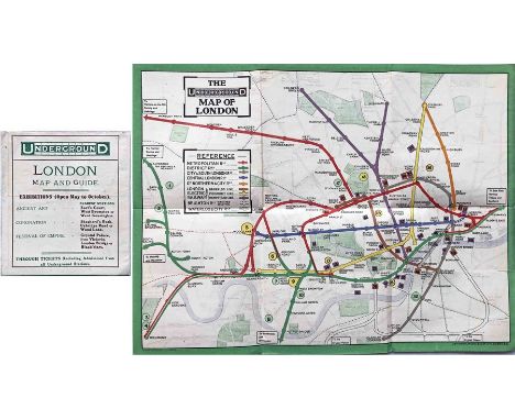
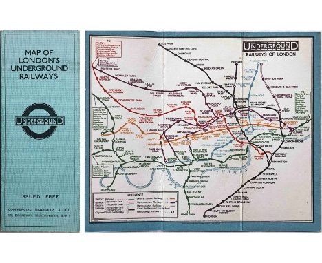
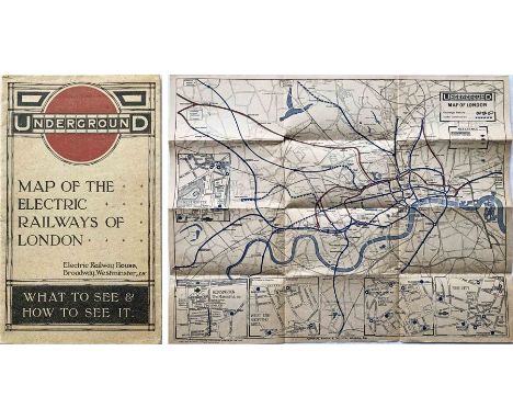
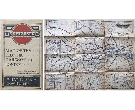
1913 London Underground POCKET MAP 'What to See & How to See it. Stations everywhere'. This is the uncommon issue with print-code 220-139M-7.11.13. Opens out to 14 " x 11" (36cm x 28cm). Shows projected extensions to Ealing Broadway, Queens Park and Edgware as well as the LNWR line to Watford in anticipation of the proposed Bakerloo extension. Cover has one of the first printed 'bar & circle' logos. A very reasonable example in used condition with some cover stains, creasing and fragile folds. [1]
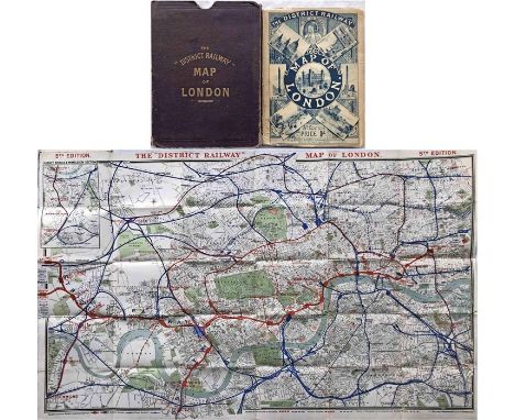
We found 109198 price guide item(s) matching your search
There are 109198 lots that match your search criteria. Subscribe now to get instant access to the full price guide service.
Click here to subscribe- List
- Grid
-
109198 item(s)/page
c1850s Carte Generale des Chemins de la France et de l’Allemagne published by Logerot, Paris (map of the railways of France and Germany). Also covers Swiss, Belgian, and parts of Dutch & Italian railways. Opens on paper to 37" x 27" (94 x 69 cm). Colour-coded key to lines plus a key to towns, cities, ferry ports, railways built, railways under construction and projected with an inset map of the Paris region. Red board covers with an image of a very early 2-4-0 loco. Worn covers with reinforced spine, some staining to map which is reinforced on reverse with archival clear tape. [1]
1935 London Underground diagrammatic, card POCKET MAP designed by Henry Beck. This is issue No 1, 1935 (no print-code) and shows the escalator connection between Bank and Monument stations. An excellent copy, crisp and firm. Carries a label on the front showing it was issued by Frames' Tours of London WC1. [1]
1905 MAP of the Electric Railways in the Metropolis and Neighbourhood prepared for the Royal Commission on London Traffic. Shows the railways existing and authorised and those proposed in sessions 1901-1905 with a key to lines constructed, under construction, authorised, proposed and to steam railways electrified. Some colour. On folded paper, opens out to 40" x 30" (102 x 76 cm). A fascinating record. Some ageing but generally in very good condition. [1]
Quantity (50+) of London Transport etc POCKET MAPS & LEAFLETS from 1930s to recently. Includes LCC Tramways 'Parks & Open Spaces', 'Rambles from Cockfosters', Bus & Tram Revised Route Numbers, Bakerloo Line extension, 1937 & 1953 Coronations, Festival of Britain guide and pocket maps, 'London' & 'Welcome' pocket maps, WW2 East Yorkshire bus map (ex-timetable book) etc etc. Mostly in very good condition. [50+]
1933 first edition of the H.C. Beck London Underground diagrammatic card POCKET MAP with the famous cover slogan "A new design for an old map....." and print-code 750M - 1-33. A lightly-used example with a few tiny marks, very small bends at the corners and a crease to the rear cover/down the r/h side of the map but overall still in very good condition. [1]
1911 London Underground POCKET MAP. Shows the CLR extension to Liverpool St under construction, the 3 separate Hammersmith stations and the LBSCR lines to Crystal Palace. Opens out to 10.5" x 8" (27cm x 20cm). In excellent condition, an ex-guidebook copy that has a trace of adhesive on the reverse at one edge. [1]
1950s British Railways (Eastern Region) quad-royal POSTER 'Norfolk - Britain's "finest" county' by Lance Cattermole (1898-1992). A colourful depiction of a map of the county onto which are superimposed small illustrations of its principal cities and towns, particularly seaside resorts. Has been professionally mounted onto acid-free conservation paper. Some light stains from the top edge downwards but generally in very good order. [1]
1976 (July) London Underground quad-royal POSTER MAP designed by Paul E Garbutt. Shows the Fleet Line from Baker Street to Trafalgar Square as under construction, the Piccadilly line extension to Heathrow Central as opening in late 1977 and the Northern City Line link from Drayton Park to Finsbury Park as opening in November 1976 . A very good example with a small stain at the top r/h corner (off map) and minor edge-scuffs. [1]
1903 MAP of London prepared for the Royal Commission on London Traffic and showing the 1846 proposed Lines of Railway and Termini referred to in that year's Report of the Royal Commission on Metropolitan Railway Termini and the limits within which the Commission recommended no railway or termini should be permitted. With a colour-coded key to the lines of 15 companies. On folded paper opening out to 32" x 28.5" (82 x 72 cm). Generally in very good condition. [1]
1903 MAP "Diagram of the Omnibus Routes in Central London" for the Royal Commission on London Traffic 1905, prepared by Mr Edgar Harper, Statistical Officer of the London County Council. The routes and termini are shown in black and the number of buses per hour on each route is printed on each section of the routes in red. On folded paper, opens out to 44" x 30" (112 x 76 cm). A most important historical document compiled well before the first public bus maps. In very good condition. [1]
1901 District Railway Map of London, 6th edition. This is the very uncommon 2nd version. It shows the development of the tube railways with the C&SLR and CLR open and the Baker St & Waterloo, the Brompton & Piccadilly and the Hampstead tubes as authorised or under construction. Also shows the proposed Brixton & City and North West London (north along the Edgware Rd from Marble Arch) railways. Linen-backed inside board covers, opens out to 41.5" x 26" (105cm x 66cm). Covers a little worn, the map is very good. [1]
1924 Metropolitan Railway POCKET MAP, the Met's own version of the London Underground map. This is the edition with print-code G.1608.100,000 and is the version with the overprint on the map for the British Empire Exhibition and Cup Final Stadium. A very good example, just lightly used with a few small blemishes. [1]
Pair of items by Fred Stingemore (1890-1954) comprising a 1921 DISTANCE MAP OF UNDERGROUND RAILWAYS, linen-backed inside card covers, opens out to 36" x 20" (92cm x 51cm), in very good, used condition plus a 1931 Underground Group Tramways Staff Dinner MENU & PROGRAMME featuring 3 pages of light-hearted cartoons by FHS on the subject of trams & trolleybuses - in very good condition. [2]
Small selection (5) of London Underground items comprising 2 x 1924 (April & July) City & South London and Hampstead Railways fold-out CARDS 'Approximate Running Times, Speeds, Distances' (good condition, some wear), undated c1924 POCKET MAP by MacDonald Gill showing British Empire Exhibition stations (used but still good) and 2 x No 1 1947 fold-out, paper POCKET MAPS (12/46) in very good condition. [5]
c1928/9 London Underground linen-card POCKET MAP from the Stingemore-designed series of 1925-32. This is one of the two first issues of the larger, second series. Unusually, it has a light-blue cover although this may have just been as a result of the usual pale green shade appearing differently during the printing process. This was issued before any of the line extensions were projected. An excellent example, crisp and firm, with only very minor blemishes. [1]
September 1911 London General Omnibus Co POCKET MAP and GUIDE TO OMNIBUS SERVICES. A very early issue (the 7th) from the first year of publication of the London bus map, which ran until 1993. Cover illustrated with a B-type bus, London's first standard motor bus. In unusually good condition, a very fine example with no material blemishes, just a little age-darkening. [1]
1921 London Underground MAP OF THE ELECTRIC RAILWAYS OF LONDON 'What to See & How to Travel' with issue date 9-3-21. Designed by MacDonald Gill with a blue decorative border and calligraphed station names, the map opens out to 13.5" x 10.5" (34 x 27cm). Generally a very good example with a little wear to some folds and a very small loss at one corner. [1]
Large quantity (150+) of 2002 Transport for London 'CONTINUING YOUR JOURNEY' LEAFLETS sorted alphabetically from Acton Town to Wood Green, all bar the top one in very good condition, very minor duplication noted, plus approx 20 copies of the 1993 London Underground FACTSHEET FOR STAFF 'Aiming Higher', each with a credit-card-size Underground map, all in very good condition. [170+ items]
c1930 National Omnibus & Transport Co Ltd MAP of the LONDON COUNTRY AREA. Linen-backed inside board covers with gold-leaf titling, the map opens out to 57" x 40" (145cm x 102cm). Based on the Ordnance Survey and hand-coloured to show the Metropolitan Police Boundary, the London Country Area Boundary, Routes of the National Omnibus Co (route numbers are shown) and Routes of other Companies run in agreement with the National. This area became the northern Country Area of London Transport in 1933. Well-used with some wear but generally very good. [1]
1914/5 London Underground pocket MAP OF THE ELECTRIC RAILWAYS OF LONDON 'What to See & How to See it'. Opens out to 17 " x 13.5" (43cm x 34cm) with 12 panels and pictorial views on the reverse. No date or print-code but c April 1914 - Jan 1915. Shows extensions to Ealing Broadway, Gunnersbury and Edgware as under construction. Circle of bullseye on cover is red. Generally a very good example with a couple of very small partings at the fold-corners and the usual age-darkening. [1]
c1892 District Railway Map of London, 5th edition (1st version). It shows the the world's first deep-level tube railway, the C&SLR, open as far as Stockwell with the Clapham extension proposed. Also shows the proposed Regent's Canal, City & Docks Railway and City Lines Railway to Barbican. Linen-backed inside card covers, opens out to 42" x 26" (107cm x 66cm). A very fine copy that, most unusually, comes with its original, titled board folder. The map is excellent, slight wear to covers, the folder has some wear. [1]
1875 District Railway MAP. A very early issue from London's second Underground railway which opened in 1868. Undated but can be attributed to 1875 as it shows the company's line from Hammersmith to Mansion House and to West Brompton and a planned westward extension to 'Shaftesbury Road' (towards Gunnersbury). Shows the District's running rights over the Metropolitan Railway and an authorised "Metropolitan & South Western Railway" line from Earls Court to Barnes. Single-sided, measures 18" x 11.5" (46cm x 29cm. Small tear at l/h edge, otherwise very good. Folded. [1]
1954 London Underground quad-royal POSTER MAP by H C Beck with print-code date of November 1954. Depicts the network in its settled post-war form that was to last until the construction of the Victoria Line in the 1960s. The lines have been thickened to allow the names to be shown within them. The term 'Railways' is now shown on the bar of the bullseye. Generally a very good example with a little age-darkening, tiny losses at the edge-corners and fold-corners, short pieces of tape at the edges on the reverse which partially shows through. Folded. [1]
1933 London Underground H C Beck diagrammatic, card POCKET MAP from the first-year series titled 'Underground Railways of London'. Issued c.December 1933 and has print reference 33-3636. This is a special edition produced for Davis Estates and shows the locations on the map of their head office and various estates. A superb copy in excellent condition - crisp and firm. [1]
Special issue of the 1909 London Underground POCKET MAP 'What to See and How to See it, The Excursionists' Guide with Map'. This version shows an illustration of Shoolbred's, the Tottenham Court Road department store (closed 1931), on the map, together with the address and an arrow pointing to Euston Square station. Opens out to 10.5" x 8.5" (27cm x 22cm). Traces of adhesive at the edges suggest this was tipped into a brochure for the store, otherwise the map is in excellent condition. [1]
Quantity (23) of 1920s/30s London Underground/London Transport GUIDEBOOKS & PUBLICITY including 1920s 'London's Country', 'London Town & Country' and 'London' (the latter complete with unique fold-out Underground map), 1933 (ref 253) Green Line Rambles, 10 copies of 1930s 'Strolls & Rambles', 'London Transport' 1934 & 1935 editions, 1933 'London's Buses, the story of a hundred years' plus misc 1930s guidebooks eg 'Imperial Pilgrimage', 'Serious Pleasures' etc. Mostly in good to very good condition. [23]
1933 first edition of the H.C. Beck London Underground diagrammatic card POCKET MAP with the famous cover slogan "A new design for an old map....." and print-code 750M-1-33. A used but very reasonable example with small cover stains but the map side is very good with just a couple of very small marks. [1]
1930s CIGARETTE CASE with engraved London Underground map on the inside including pre-WW2 bullseye logo. Undated but map shows Underground service on the West London line (Uxbridge Rd & Addison Rd) which ceased during WW2. Manufactured by Tallent in silver-coloured and gold-coloured metal with two spring-loaded cigarette compartments. In very good condition with a little wear on the outside. [1]
Selection (10) of 1920s-40s BUS & TRAM HANDBILLS comprising Leicester City Tramways 1925 'Coming of Age', 1926 'How to distinguish Trams at Night' & 1937 Coronation Week + TIMETABLE BILLS for South Yorkshire Motors 1946 x 4, Ebor Bus Company 1948, Everingham Bros 1948 & Haslingden Corporation 1949 + a 1930s City of Leicester Passenger Transport OFFCIAL HANDBOOK with fold-out map of tram & bus routes. Generally in good to very good condition. [11]
1914/5 London Underground pocket MAP OF THE ELECTRIC RAILWAYS OF LONDON 'What to See & How to See it'. Opens out to 17 " x 13.5" (43cm x 34cm) with 12 panels and pictorial views on the reverse. No date or print-code but c April 1914 - Jan 1915. Shows extensions to Ealing Broadway, Gunnersbury and Edgware as under construction. Circle of bullseye on cover is red. Generally a good example with short partings at two fold-corners and the usual age-darkening. [1]
Special edition of the London Underground diagrammatic POCKET MAP, a paper version of the Garbutt design produced c1965 for distribution to arriving passengers at the British European Airways (BEA) West London Air Terminal in Cromwell Road with walking directions to Gloucester Road station. A most unusual item. In excellent, unused condition. [1]
1902 'District [Railway] MAP of Greater London & Environs', 1st edition. Shows the first tube railways (C&SLR & CLR), indexed as 'Electric Railways' and also the authorised extension of the Metropolitan Railway to Uxbridge. A linen-backed map inside hard covers, it opens out to 42" x 27" (107cm x 68cm). Heavy wear to the covers with small corner loss, original owner's name on front cover, the map is in good, used condition. [1]
Selection (3) of 1912 London General Omnibus Co POCKET MAPS and GUIDES TO OMNIBUS SERVICES. Early issues from the second year of publication of the London bus map, which ran until 1993, these are for July, August and September 1912. Covers illustrated with a B-type bus, London's first standard motor bus. In used but reasonable condition with some fold partings. [3]
Selection (8) of Underground-related GUIDES & MAPS comprising c1908 British Tea Table LONDON GUIDE BOOKLET with fold-out, independently-produced tube map (used condition, map is loose), 1924 British Empire Exhibition at Wembley official, fold-out GUIDE with a map designed by Kennedy North in MacDonald Gill style with an Underground map with calligraphed station names and elaborate, colourful illustrations (well-used with wear) plus a selection of Underground DIAGRAMMATIC CARD MAPS: 8/60, 1/65, 8/66, 4/72, 6/85 & 2/91 (good condition, lightly-used). [8]
1933 London Underground H C Beck diagrammatic, card POCKET MAP from the first-year series titled 'Underground Railways of London'. This is the edition with no print-code, issued c. August 1933 and has 'LPTB' inside the bullseye logos. Refers to re-naming of Dover St station to Green Park and the merger of Holborn and British Museum stations, all in September that year. A lightly-used example with a little wear and a short tear visible on the front cover to the right of 'London' and just visible on the map-side but otherwise a very good example. [1]
Pair of 1924 British Empire Exhibition at Wembley fold-out GUIDES, the first is the BEE official guide with a map designed by Kennedy North in a style similar to MacDonald Gill with an Underground map with calligraphed station names and elaborate, colourful illustrations and the second is the Underground Group 'Way to...and Way About' guide showing bus, tram & Underground connections as well as a plan of the site. The first is in lightly-used condition with some cover wear but good when opened out, the second is in very good condition. [2]
c1910 Evening News LONDON TUBE MAP & GUIDE. Produced by George Philip & Sons and features a unique cover design of tunnel segments, one for each tube line (the sub-surface Underground lines are given equal status on the map!). Folds out from card covers to 23.5" x 19.5" (60cm x 50cm) and has a tramways map on the reverse. In good condition, light wear to the covers. [1]
Christo*, The Gates, Lithography, fabric sample and 2 brochuresChristo* (Christo Javatscheff), (1933-2020)The Gates. Farblithografie. 52 x 60 cm. Unten links mit Bleistift signiert. Foto von Wolfgang Volz 2004, Hrsg. Kunstverlag Schumacher, Düsseldorf. Beiliegend ein Musterstück des Stoffes, 7x7 cm, und zwei Broschüren, The Gates Map und The Gates Views. Christo*, The Gates, Lithography, fabric sample and 2 brochuresChristo* (Christo Javatscheff), (1933-2020)The Gates. Color lithograph. 52 x 60 cm. Signed in pencil lower left. Photo by Wolfgang Volz 2004, published by Kunstverlag Schumacher, Düsseldorf. Enclosed is a 7x7 cm sample of the fabric and two brochures, The Gates Map and The Gates Views.
Jasper Morrison, Map from Reuters News Centre, documenta 8, 1987Jasper Morrison1987Landkarte, ein Objekt aus der Installation Reuters News Centre, documenta 8. Schulwandtafel / Rollkarte Weltkarte. 135 x 190cm.Literatur: Jasper Morrison. [Hrsg. Peter Teichgräber]. Katalog Ausstellung Prodomo Wien, 1988, [Katalog Nr. 6 Prodomo Wien], S. 21. Jasper Morrison, Map from Reuters News Centre, documenta 8, 1987Jasper Morrison1987Map, an object from the Reuters News Center installation, documenta 8. School blackboard / roll map world map. 135 x 190 cm.Literature: Jasper Morrison. [Hrsg. Peter Teichgräber]. Katalog Ausstellung Prodomo Wien, 1988, [Katalog Nr. 6 Prodomo Wien], S. 21.
The Racing Car Explained - Tuning Side-valve Fords - The Ford Cortina - A collection of 18 vintage motoring related books, and a vintage map. Includes The Wonder Book Of Motors, Road Car Racing And Preparation and a vintage Motoring and Hiking map of Yorkshire/Derbyshire. All show signs of age and wear, overall condition is Fair to Good.
-
109198 item(s)/page