We found 109198 price guide item(s) matching your search

Refine your search

Year

Filter by Price Range
  • List
  • Grid
  • 109198 item(s)
    /page

Lot 417

YULE, COL. HENRYA NARRATIVE OF THE MISSION SENT BY THE GOVERNOR-GENERAL OF INDIA TO THE COURT OF Calcutta: Thacker, Spink & Co., [1857]. 4to, 20 tinted or coloured lithographed plates, 6 plain lithographed plates, 3 coloured maps, folding map at end, illustrations, modern quarter calf retaining original gilt spine, orange cloth, slight dampstain at foot of titleProvenance: From the collection of Larry Hutchison

Lot 88

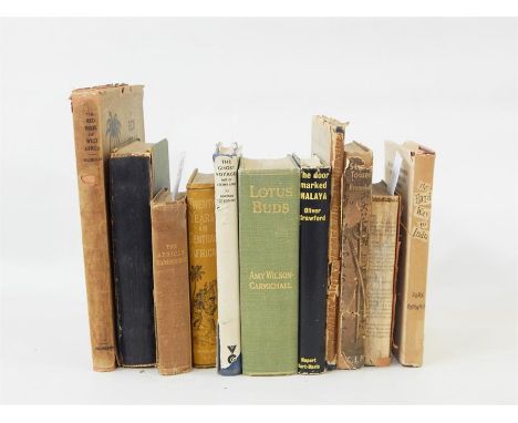
SCOTLAND, ANTIQUARIAN, 8 VOLUMES INCLUDINGTHE ACTS & ORDERS OF THE MEETING OF THE ESTATES of the Kingdom of Scotland. Edinburgh, 1690; The Laws & Acts made in the First [-Ninth] Parliament of... William & Mary. 1690-1701, bound with 2 others, contemporary calf, slight spotting, rubbed, rebacked; Arnot, Hugo A Collection and Abridgment of Celebrated Criminal Trials in Scotland. 1785. 4to, contemporary calf, rubbed; Literary and Antiquarian Society of Perth Transactions. Perth, 1827. 4to, plates, contemporary quarter morocco, slightly spotted, slightly rubbed; [Trial] of Duncan Terig Alias Clerk... for the Murder of Arthur Davis. 1831. 4to, contemporary half morocco, slightly rubbed; Dobie, J. Cunninghame, Topographized by Timothy Pont. 1876. 4to, folding map, plates, contemporary half morocco, neatly rebacked; Martin, George The History and Antiquities or St. Rule's Chapel. 1787, 4to, extracted from a larger work. modern half calf gilt; Martine, G. Reliquiae divi Andreae. St. Andrews, 1797. 4to, 3 engraved plates, contemporary half calf, joints split; Wingate, James Illustrations of the Coinage of Scotland. 1868. 4to, limited to 150 copies, plates, contemporary green morocco gilt, t.e.g., small stain to upper corner of some plates, rubbed; sold not subject to returnProvenance: From the collection of Larry Hutchison

Lot 398

An Edwardian piano stool, coffee table depicting map of the world and a wicker sewing box

Lot 321

1938-55 2½d 'Map of Fiji Islands', perf 14, lower right corner block of four the lower left stamp showing the Extra Island, pos. 10/5 (SG 256/a), minor creasing a the foot of the lower margin otherwise fine u/m and a lovely positional multiple

Lot 428

Quantity of framed pictures and prints with gallery advertising posters and modern map prints

Lot 306

Modern map of Lancaster, Japanese woodblock, etc

Lot 414

Robert Morden, map of Hertfordshire, 37 x 45cm

Lot 475

Robert Morden (1668-1703) - Coloured engraving - "Map of Kent", 14ins x 25.5ins, in Hogarth frame and glazed

Lot 476

Herman Moll (1654-1732) - Coloured engraving - "A New Map of Italy, Distinguishing all the Sovereignties in it, Weather, States, Kingdoms, Dutchies, Principalities, or Republiks...", with views of Mount Vesuvius and Mount Etna, 41ins x 24.5ins, framed and glazed

Lot 69

"London County Council Survey of London", vol 18 'The Strand, the Parish of St Martin and Fields part 2 1937', ill though the text and vol 8 'The Parish of St Leonard, Shoreditch 1922', photographic ills, folding map, hinges cracked, all rather bumped and worn Morton, H V "In Search of Ireland", Methuen & Co 1931, photographic ills, half leather, marbled bds, gilt titles but rather worn  Dugdale, Thomas "Curiosity of Great Britain, England and Wales ...", vol 4 only, numerous engravings, engraved ills, double maps, marbled bds, half leather, rather worn and two other volumes (6) 

Lot 70

Militaria  "Record of the Cold Stream Guards 1650-1918", "Record of the Cold Stream Guard 1650-1950" Herbert, A P  "Let Us Be Glum", Methuen 1944, black cloth, dj  "Friendships Offering, a Literary Album and Annual Remembrancer 1913", Cornish Brothers, limp cloth Von Bernhardi, General Frederich  "Germany and the Next War", Edward Arnold 1914, lacking front cover Howarth "The Dawn of D-Day" Neugebauer, M Norwid  "The Defence of Poland, September 1939", ex-library "The King and the Somme Film ...", numerous photographs of the Battle of the Somme, lacking covers and bound with tape "The Battle of Egypt, the Official Record in Pictures and Map"  "The Daily Mail War Atlas" 32 pages Hamilton, Sir Ian "The Scottish National War Memorial", Grant & Murray 1932 Hitler, Adolf "Mein Kampf", Hurst & Blackit, November 1939, blue cloth  A German Magazine dated 1937 Ciborowski, Adlof "Walsall, a City Destroyed and Rebuilt" 1969 and other volumes 

Lot 71

Quantity of books on travel including:- "The Red Book of West Africa" Henry W Cave "The Ruined Cities of Ceylon", Hutcheson & Co 1904 Lee, Mrs R  "The African Wanderers; or the Adventures of Carlos and Antonio ...", J Harris 1850 with engraved plates, hinges cracked, cloth all rather worn Rowley, The Rev Henry "20 Years in Central Africa ...", Wells Gardner Darton & Co, folding map, yellow dec cloth but rather worn and bumped  Nansen's, F  "Farthest North", vol 2 only, George Nunes 1898 De Poncins, Gontran  "The Ghost Voyage out of Eskimo Land", Victor Gollanz 1955, dec ep, blue cloth, dj not price clipped but rather chipped and worn Hunt, John  "Our Everest Adventure", Rockhampton Press 1954, pictorial cloth, dj rather worn and chipped  Seymour, John  "The Hard Way to India" Crawford, Oliver "The Door Marked Malaya", Rupert Hart Davis 1958, dj  "Murray's Handbook of South Italy and Naples" "The Transactions of the Asiatic Society of Japan"  Helmericks, Constance  "We Live in Alaska", Little Brown & Co 1944, photographic ills and various other volumes 

Lot 73

Cochrane, Captain J D  "Narrative of Pedestrian Journey through Russia and Siberian Territory, etc", vol 2 only, folding map which is torn near the hinge, front bd missing, contemporary blue bd Bunyon, John  "The Pilgrims Progress", vol containing "A Plan of the Road from the City of Destruction to the Celestial City adapted to the Pilgrim's Progress", a coloured folding map, the book itself broken hinged and with a paper cover, publ Bennett in 1820  "The Universal Geography" with ills and maps, brown pictorial cloth (3) 

Lot 80

Aiken, Joan  "The Wolves of Willoughby Chase", Jonathan Cape 1962, authors signature on tp, ills, brown cloth with silver titles, dj not price clipped  "Night Birds on Nantucket", Jonathan Cape 1966, ills, map on ep, black cloth, gilt titles, dj not price clipped  "The Stolen Lake", Jonathan Cape 1981, blue cloth, dj not price clipped  "The Cuckoo Tree", Jonathan Cape 1971, green cloth, dj  "Black Hearts in Battersea", Jonathan Cape 1964, black cloth, dj not price clipped  Woods, Margaret L  "Come Unto These Yellow Sands", ill by J Hancock, John Lane, The Bodly Head 1915, colour plates (not collated), the whole book worn with hinges cracked and backstrip separating  Dowd, J H & Spender, B E  "Serious Business", Country Life Limited 1937, delightful images throughout, inscription on ffep dated 1941, green cloth, red titles (7) 

Lot 83

Norie, J W  "A Complete Epitomy of Practical Navigation ..., including a journal of a voyage from London to Australia ...", Wilson Late Norie and Wilson 1877, numerous ills, plans, maps, etc, full leather but bds detaching and backstrip Scott, Peter Lt Cdr  "The Battle of the Narrow Seas", Country Life (nd), colour frontis, map on ep, ills, pale blue cloth with blue titles and decs Simper "Beach Boats of Britain", The Boydell Press 1984, ex-library, ffep torn out, dj not price clipped  Slade, W J & Greenhill, Basil  "West Country Coasting Ketches", The Conway Maritime Press 1974, dj  Todd, John & Whall, W B "Practical Seamanship for the use in the Merchant Service", 5th ed enlarged, George Philip & Son 1904, frontis, with tissue guard, various ills, some plans, maps, etc, cloth but very rubbed and worn the book is cocked (5) 

Lot 98

Map of "Magnai Britanniae ... Regnum Angliae ... Exhibet Ioh Bapt Homan Noribergae", coloured map, cartouche top right hand corner and at the bottom of Wise men with the King, the map has split in the middle under the frame, 57cm x 48cm within the margin

Lot 104

After Bleau Colour map "Wiltonia ... Wilshire from Theatrum Orbis", 41cm x 49cm, the central crease can be seen and parts are raised under the frame

Lot 415

After Joanne Blaeu, Wigorniensis and Warwicsensis, (Worcester, Warwick and~The Liberty of Coventry), hand-coloured engraved map, 42 x 51cms.

Lot 446

An Antiquarian Map of Rutland, Robert Morden "Comitatus Rotelandiae Tabula Nova & Aucta" sold by A Swale, A Churchill & Partners, 29cm x 37cm, a reproduction map of Lincolnshire. (2)

Lot 447

Robert Morden, Northamptonshire, hand-coloured county map, 36cm x 41cm, framed and glazed.

Lot 457

After John Speed, Comitatus Northantonesis (Northamptonshire), hand-coloured county map, 40 x 50cms.,

Lot 458

John Speed - an antiquarian map of Staffordshire,

Lot 432

A William IV mahogany library cabinet, two panelled doors, leaf scroll and stylised decoration, flanked by a pair of columns with stylised capitals, fitted interior with vertical map cabinet, 117 cm wide x 58 cm deep x 111 cm high

Lot 66

Robert Morden (c. 1650 - 1703) map of Shropshire, taken from a book, later coloured, framed, 37 cm x 42 cm. Together with Robert Morden map of the county of Lancaster, 45 cm x 39 cm (2)

Lot 315

A Framed Map of Staffordshire by John Cary

Lot 182

A BROWN LEATHER CASE WHICH CONTAINS A WOODEN CONSTRUCTED ROLLING DESIGN MAP OF THE U.K, the case is by J.C. Vickery of London and has the large initials M.O., the map is scrolled through and is in good condition

Lot 122

A hand tinted map of Suffolk, by Robert Morden, mounted and framed

Lot 12

A selection of miscellaneous including early 20th century Philips Planisphere scale, vintage glass negatives for Halley's Comet, a Cadbury Yard chocolate box, two vintage yard sticks, a monthly Star Map volume 1911, three Roy Rogers albums and a Knock Out annual 1957

Lot 195

A map after Christopher Saxton and Philip Lea, 18th century, Cumberland and Westmorland, later colouredThe line on the photo is a  reflection, condition ok

Lot 196

A map after Robert Morden, 18th century Durham, later coloured

Lot 197

A linear map after Harris, 18th/18th century, The East and West parts of the River Thames

Lot 198

A map after J Ellis, 18th century, Cumberland, later coloured

Lot 329

A small carton. Local history and related. Includes; Wainwright, A. 'Westmorland Heritage', signed limited edition; 'Some Records of Troutbeck'; West, 'A Guide to the Lakes', London: 1784, 3rd edition, with map. Etc. (15)

Lot 34

A large collection of printed travel ephemera, mainly 1950's and 1960's, comprising road and town maps (including a 1942 road map of India, Michelin, etc.), rail, bus, air and cruise line material (including some BOAC and Cunard items), many tourist information brochures and leaflets, including Europe, Asia, Canada, USA, Russia, museums and art galleries, a holiday scrapbook and sundries

Lot 399

A Robert Morden map, the Kingdom of Ireland, 1695 or later ('Newry' spelled correctly), unframed, 45 x 39cm

Lot 1788

The History Gazeteer and Directory of Cheshire by Francis White and Co in half calf 1860 ( map not included )

Lot 466

Browning, Robert H.K. - Golf Club Handbooks (4) to incl The Wrekin Golf Club Wellington Shropshire, The Strawberry Hill Golf Club Twickenham London, Calcot Golf Club Reading, Dunstable Downs Golf Club and Brookmans Park Golf Club North London - usual soiling to the edges - overall (F/G) plus Enville Golf Club (Staffs) road map showing the new positon of the club house (5)

Lot 767

London Golf Clubs Annual 1937 - "50 Miles of Golf Round London" 1st ed in the original pictorial boards with cloth spine together with the original folding map (complete but with one tear to one corner hence loose), owners name and address written to the first title page, internally clean although there is some foxing to the front and rear free end plates

Lot 288

A small lot of collectables including wristwatches, Barnsley and Sheffield ordnance survey map, chrome cigarette case and a copper lustre mug.

Lot 294

Two 1970s Mdina art glass vases and a reproduction John Speede map of Derbyshire.

Lot 1080

A framed survey map of the Moray Firth from Dunrobin Point to Buckie, 70 x 102cm

Lot 1363

A rustic part grey painted pine slopefront writing bureau, the panelled slopefront later inset with map of Weymouth and surrounding coastline, over two short and two long drawers, w.84.5cm

Lot 181

A Hummel table lamp as a seated flowerboy (lacking shade and fittings), height 19cm, together with a reproduction Captain Cabin map reading compass in glazed case (2)

Lot 290

An 18th century engraved map of Bavaria, 44 x 56cm, unframed

Lot 465

A map, showing the disposition of Luftwaffe units on 7th September 1940, during World War II, 120 x 90cm

Lot 691

A collection of prints signed by Edward Lange, Frigate Unicorn under sail, lithograph, 52 x 40cm, together with RRS Discovery at Sea, lithograph, and a map of the British Empire (3)

Lot 138

Vintage Map / Print or Storage Box in the form of a Large Leather Bound Antique Book, the spine marked ' Prints: Topographical Wales ' 88cms x 68cms

Lot 139

Vintage Map / Print or Storage Box in the form of a Large Leather Bound Antique Book, the spine marked ' Maps Welsh Counties ', 88cms x 68cms

Lot 140

Vintage Map / Print or Storage Box in the form of a Large Leather Bound Antique Book, the spine marked ' Drawings: Topographical Wales ', 88cms x 68cms

Lot 683

An early 20th Century oak and oak ply plan or map chest of six drawers, with applied brass cup handles, height 89cm, width 123cm and depth 90cm, S/D.From the estate of the late Richard Beer

Lot 1045

Seven boxes forming a library of coaching, hunting, riding, racing and similar horse-related books (as well as some on dogs) including Underhill, Driving for Pleasure, 1904, publisher's quart.-lthr; Strong, The Hansom Cab and the Pigeons, Golden Cockerel, limited of 1000, illus. by Ravilious, in worn dj; Mogg's Ten Thousand Cab Fares with Map; Shone, A Century and a Half of Amateur Driving, 2 vols, quart.-lthr; Phillipson on Harness; Littauer, The Forward Seat; and Howlett, Driving Lessons, 1894. With a wide variety of others including Gilbey, Selway, Nimrod, Somerville, Edwards, Hussey and Harper and a number of pamphlets

Lot 405

CHRISTOPHER SAXTON A MAP OF STAFFORDSHIRE, hand coloured, 28cm x 31cm, unframed

Lot 406

A MAP OF THE COUNTY OF WARWICK, published by Greenwood and Co., London. 1830. Some hand colouration, 47cm x 68cm, unframed

Lot 407

AN EARLY MAP OF STAFFORDSHIRE, bears date 1607, hand coloured, includes Royal Arms, 28cm x 31, in ebonised glazed frame

Lot 408

CHRISTOPHER SAXTON AN 18TH CENTURY MAP OF HEREFORDSHIRE, hand coloured, includes the Royal crest, 28cm x 30cm, mounted in gilt glazed frame

Lot 1068

TALISKER 10 YEARS OLD - MAP LABEL Active. Carbost, Skye. 70cl, 45.8% volume, in carton.

Lot 1199

TALISKER 10 YEARS OLD - MAP LABEL Active. Carbost, Skye. 70cl, 45.8% volume, in carton.

Lot 66

One Volume 'Reports of Cases Decided by the Railway and Canal Commissioners' together with a small book collection and a hand coloured Map of Kent, 27 x 35 cms

Lot 217

A group of collector's items, including New York World's Fair souvenir, Cunard White Star menus, framed stamps, East Riding of Yorkshire map, Papua New Guinea bamboo pipe and Victorian walking stick penwork-decorated with a hunting scene

Lot 1234

Thomas Kitchen, circa 1768, A New map of Westmore-land, hand coloured engraved map, 19.5cm x 25.5cm, framed and glazed, Robert Morden - Westmorland, engraved map in a book on the county with table of the county, original boards, 23.5 x 18.5cm and an 18th century monochrome watercolour of Kendal Castle, 10.5cm x 15.5cm (3).

Loading...Loading...
  • 109198 item(s)
    /page

Recently Viewed Lots