We found 109198 price guide item(s) matching your search
There are 109198 lots that match your search criteria. Subscribe now to get instant access to the full price guide service.
Click here to subscribe- List
- Grid
-
109198 item(s)/page


Lot 198
A wooden crate containing a collection of vintage toys to include a Chad Valley roulette wheel, a collection of chess pieces, wooden animal figures, vintage Meccano pieces, vintage die-cast vehicles, a French carved wooden cat face with articulated mouth, a painted metal toy stove / burner, etc, together with a cardboard box containing a collection of postage stamp albums, a military map depicting Egypt, a draft/foreword referring to 1st July 1946 6th Armoured Division, a 19th Century map of Africa, etc

Lot 330
AFTER JOHN SPEEDE "Countie Palatine of Lancaster described ....", map, black and white engraving, later coloured CONDITION REPORTS Size of printed image approx 50.5cm x 38cm. Plate mark visible around printed image. Overall quite browned/yellowed and with creases and dirt. The print is sealed within the frame, so unable to ascertain whether or not the print is stuck down / laid down. Quite pronounced creases, including large crease / possibly a repair running horizonally from about a third of the way down and across the map. Fold down centre of map with some wear and some touch up colouring along and near the fold. The area inscribed "Performed by John Speede and are to be sold by Henry Overton ...." - the wording to this area is quite distorted and worn and creased, with some touch up paint around this area, and it may have had some repair or alteration here. There is a black smudgy ink-like line running vertically through the left part of the Lancaster plan. This map is believed to be a 17th Century print.


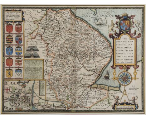
Lot 100
Lincolnshire.- Speed (John) - The Countie and Citie of Lyncolne Described, county map with ornamental title cartouche, coats of arms, battle scene, inset plan of Lincoln, and ship and sea-monster, engraved map with full hand-colouring, 390 x 520mm., English text on verso with woodcut initial by William Hall and John Beale, central vertical fold, with minor tears to lower centre, discolouration to central fold, light browning, Sudbury and Humble, [1611-1612].

Lot 108
Sayer (Robert) and John Bennett. - The London Directory, or a New & Improved Plan of London, Westminster & Southwark, from Angel, Islington to Newington Butts, and from Shadwell Docks to Hyde Park, titled above with extensive key below, engraved map with full oriignal hand-colouring, 410 x 520mm., dissected and line-backed, slight surface dirt and minor spotting, folding into contemporary marbled slipcase, [Howgego 138 (6)], 1781.
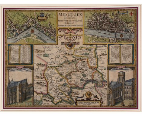
Lot 110
Middlesex.- Speed (John) - Midle-sex described with the most famour Cities of London and Westminster, 1st issue, with inset plans and views of St Paul s and Westminster Abbey, engraved map with hand-colouring, 385 x 510mm., English text verso with woodcut initial by Hall and Beale, central vertical fold, several repaired tears, even browning, light spotting and surface dirt, Sudbury and Humble, 1611.


Lot 117
Smith (W.,mineral suveyor) - Geological map of Sussex, title above, addiontal title cartouche, 'A New Map of Sussex Divided into Hundreds', upper left, coloured to distinguish the underlying geology, engraved map, original hand colouring, slight browning and repaired split on central vertical fold, John Cary, c.1819

Lot 118
Speed (John) - Sussex described and divided into Rapes, inset town plan of Chichester, battle scene, coats-of-arms, ships and sea-monsters, engraved map, 390 x 510mm., English text on verso with woodcut intial by Thomas Snodham, central vertical fold, repaired tear through the title cartouche, sheet edges frayed, minor creasing, John Sudbury and George Humble c. 1614/16.


Lot 26
Roberts (Emma) - Hindostan, its landscapes, places, temples, tombs; The Shores of the Red Sea , 2 vol. in 1, frontispieces, additional engraved titles and 97 engraved plates, lacking map, some scattered foxing, preliminary leaves browned, contemporary half straight-grained roan, upper crease cracked, rubbed, 8vo, [c.1850].
Lot 294
Marshall (John) - The Life of George Washington, 5 vol., 2 folding engraved maps only (of 12), lacking plates, original boards, some covers detached or becoming loose, spines chipped, 1804-07 § Stevenson (Robert Louis) Kidnapped, being Memoirs of the Adventures of David Balfour in the Year 1751, first edition, intermediate issue with "business" on p.40 but 9pp. publisher s catalogue at end dated 5G.7.86 , half-title, folding colour map, original green cloth, slight shelf-lean, spine slightly darkened, spien ends and corners a little bumped, 1886, 8vo ; sold not subject to return.

Lot 3
Australia.- Basire (James) - Map of Australia, Compiled from the Nautical Surveys, Made by Order of the Admiralty, And other Authentic Documents, for the Report of the Select Committee on Transportation, lithographed map with original hand-colouring, 445 x 630mm., linen-backed with old folds, sides edged in green silk, slight surface dirt, The House of Commons, 1837.
Lot 344
Lawrence (T.E.) - Revolt in the Desert, plates, folding map, endpapers browned, original buckram, near-fine, dust-jacket, a little browned at margins, 1927 § Joyce (James)Stephen Hero, original cloth, dust-jacket, some light spotting, 1944, first editions, excellent examples ; and c.50 others, modern literature and art, many in superb condition, 4to & 8vo (c.50)
Lot 4
Bibliography.- - The Map Collector, 73 vol., comprising issue nos 1-35, 37-45, 47-50, 52-72, including a few duplicates, original wrappers, some spines a little faded, lightly rubbed , 1977-1996; together with a small quantity of others, similar cartography, including Koeman's Atlantes Neerlandici (1967), v.s. (c.90)
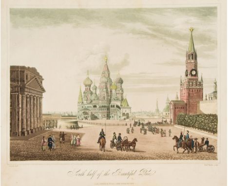
Lot 41
Lyall (Robert) - The Character of the Russians, and a Detailed History of Moscow..., first edition , 22 engraved plates only (of 23, lacking folding panorama of the Kremlin), 12 hand-coloured, 3 folding, and large folding engraved map of Moscow, some light foxing, ink inscription and bookplate of james Whatman to front free endpaper and front pastedown respectively, new endpapers, later half calf, recased, preserving 3/4 of the original backstrip, 4to, 1823.

Lot 43
Plescheef (Sergey) - Survey of the Russian Empire, translated by James Smirnove, third edition, folding engraved map, lacking plates, slightly foxed and soiled, new endpapers, later leather, 8vo, J. Debrett , 1792 § Storch (Heinrich Friedrich von) The Picture of Petersburg, from the German, engraved frontispiece, engraved vignette title and folding plan, plate, a couple of repaired tears, some browning and foxing, new endpapers, modern half calf, 1801, 8vo (2)
Lot 46
Tooke (William) - View of the Russian Empire, 3 vol., second edition, folding engraved map, some foxing and browning, contemporary calf, spine gilt in compartments with red and green labels, spine ends worn and joints split at ends, 1800 § Morton (Edward) Travels in Russian In the Years 1827-1829, contemporary half calf, gilt, spine gilt in compartments, 1830; and 2 others, Russia, 8vo (6)
Lot 58
Shepherd (C.W.) - The North-West Peninsula of Iceland, colour printed map and 2 chromolithographed plates, re-cased, some staining, 1867 § Pairpoint (Alfred J.) Rambles In America, Boston , 1891 § Sharpe (Sir Alfred) The Backbone of Africa, some spotting, modern half morocco, 1921 § Thomas (Bertram) Arabia Felix, original 1932 § Lawrence (T.E.) Oriental Assembly, 1939 § Scott (Hugh) In the High Yemen, second edition, spine faded, 1947, all but the third in original cloth ; and c.35 others, travel, v.s. (c.40)
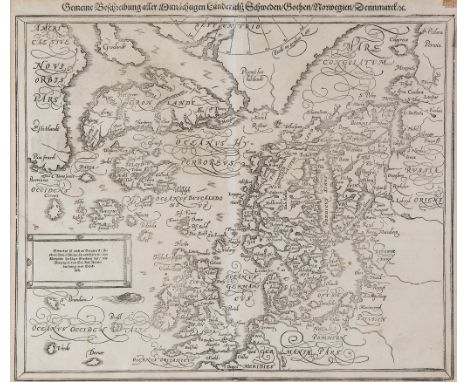
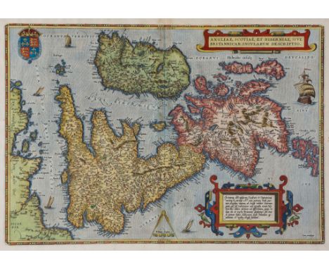
Lot 63
Ortelius (Abraham) - Angliae, Scotiae, et Hiberniae, sive Britannicar: Insularum descriptio, the British Isles, Ireland and the north coast of France, north oriented to the right, with strapwork cartouches, upper and lower right, a galleon and 4 sail boats, engraved map with hand-colouring, 345 x 500mm., Latin text verso ending with putaveris and page number 10, central vertical fold, some light browning and spotting [vdB. 16], Antwerp, [1592 or later].

Lot 74
-. Speed (John) - Cornwall, inset views of Launceston and stone monuments, armorial cartouche, ships and sea monsters, with coats-of-arms below, engraved map by Jodocus Hondius, with hand-colouring, 385 x 510mm., English text verso with woodcut initial by William Godbid, central vertical fold, Bassett & Chiswell, [1676].

Lot 76
Devonshire.- Blaeu (Johan and Willem) - Devonia vulgo Devon-shire, county map with decorative title cartouche of merchants, putto, kingfishers and sheep, lower right, coats-of arms in upper corners, engraved map with original hand-colouring, 395 x 500mm., Latin text verso, central vertical fold, Amsterdam, [1645 or later].


Lot 90
Essex.- Speed (John) - Essex, devided into Hundreds after John Norden, with inset bird s-eye plan-view of Colchester, surmounted by roman coins, and armorials of the earls of Essex to the left, engraved map with hand-colouring, 390 x 510mm., Latin text verso with woodcut inital by John Beale, central vertical fold, G. Humble, [1611-12].
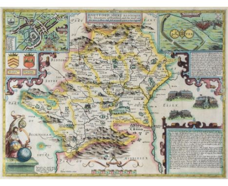
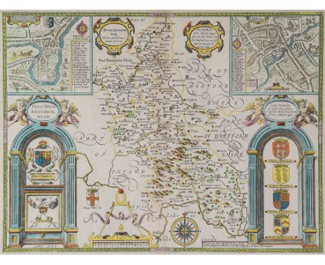
Lot 95
Hertfordshire.- Speed (John) - Hartfordshire Described, inset views of Hertford, Roman St Albans, text panels, with battle scene and allegorical figure with astrolabe below, engraved map by Jodocus Hondius, with hand-colouring, 385 x 510mm., text verso with woodcut initial by Hall and Beale, central vertical fold, light browning and surface dirt, Sudbury and Humble, c.1611-1612


Lot 361
After Randolph Caldecott, Hunting prints and two postcards, after Henry Alken, aquatint by Duncan of 'To the Crack Riders of England', a small Albert Buckle etching of York Minster, circa 1880, a reproduction map of the Railways of Norfolk and a coloured engraving for The Complete English Traveller entitled 'View of the remarkable Cataract on the River Teese which divides the Counties of York and Durham' and other topographical prints (all framed & glazed)


Lot 1819A
Folkes (Martin) - A table of English silver coins From The Norman Conquest to the present time, printed for the Society of Antiquaries, London, 1745, further books to include Whewell's Scientific Ideas, two volumes, eight copies of The Gentleman's Magazine, dates from 1742-1835, Text book of Geology in two volumes, Elementary Text Book on Zoology etc., also two engravings of Italian Interior Scenes. (26) CONDITION REPORT: Lot 1819: Specific years of the gentleman's magazines 1742 1743 1744 1750 1752 1825 (two volumes) 1855 (one volume). 1744 no folding plates or maps. 1743 no folding plates or maps. 1742 folding plate with map, a plan of the City of Prague some staining and a tear within the oval of the portrait. 1750 folding plate, Prospect of Mount Etna folding plate depicting four bridges including the new bridge of the Thames at Walton, another the Grand Duke's Gallery, inside St Stephen's Walbrook, view of Fontanbleau Vulcan's Court Naples, a classical two handled urn, St Paul's choir, Vesuvius, and east Indian leopard. 1762 folding plate of Doge of Venice, other plates but non folding. 1855 folding plate Pantheon London other plates but non folding. 1825 the steeple of St Brides church 1825 (second volume) no folding plates or maps.


Lot 1830
H Moll, engraved map of the Isle of Man The double plate map with a view of Peel Castle, in a presentation bearing by Captain G Collins to the Honorable William of Derby. 46x59cms framed, and another, presented to the Honorable Sir John Lowther each framed as a pair, 29 and 31 top left hand corner. 46x59cms. (2)


-
109198 item(s)/page