We found 109182 price guide item(s) matching your search
There are 109182 lots that match your search criteria. Subscribe now to get instant access to the full price guide service.
Click here to subscribe- List
- Grid
-
109182 item(s)/page


Lot 1286
John Speed (1551 - 1629) A map of "The Bishoprick and Citie of Durham" bearing inscriptions detailing the erection of the city and the Battle of Neville's Cross, with "A Table of all the Towns in the Bishoprick of Durham" verso, watercolour tinted engraving, in moulded wooden frame under glass, 59 cm x 45 cm overall


Lot 117
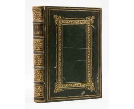
NO RESERVE Bourassé (Jean-Jacques, l'abbé) La Touraine. Histoire et Monuments, half-title, chromolithographed additional title and 3 plates, 14 steel-engraved plates, all by Karl Girardet & F. L. Francais, one map (hand-coloured in outline), wood-engraved illustrations throughout, occasional light foxing, attractive contemporary green morocco, richly gilt, spine slightly sunned, some rubbing and a few small stains, lower joint split at foot, g.e., [Brunet I, 1174], folio, Tours, 1855.
Lot 16
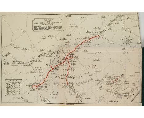
NO RESERVE China.- South Manuria Railway.- Souvenir Album, photographic illustrations, additional folding map of the South Manchuria Railway with route picked out in red tipped in, photographic illustrations, some chipping to final f., original pictorial cloth, rubbed and a little marked, oblong 4to, [c.1910].⁂ Rare photographic book, a partial guide to the places and customs of then Manchuria as well as a celebration of Japanese conquest of the region and the construction of the railway. This copy with a map of the railway seemingly issued separately to this publication.
Lot 171
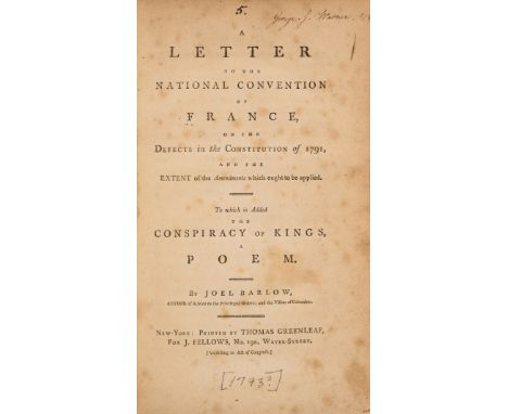
Barlow (Joel) A Letter to the National Convention of France on the defects of the Constitution of 1791, small contemporary ink ownership inscription to title, title lightly foxed, modern half cloth, New York, by Thomas Greenleaf for J. Fellows, [1793]; The Political Writings of Joel Barlow, ink ownership inscriptions to title and front endpaper, light uniform browning, contemporary calf, worn, New York, by Mott & Lyon, 1796 § Cartwright (John) England's Aegis, or the Military Energies of the Empire, folding engraved map and plate, bookplate, contemporary calf, rebacked, for Richard Phillips, 1804; and 3 others French Revolution, v.s. (6)⁂ I. Joel Barlow (1754-1812) was an American poet, diplomat and politician. He lived in Paris during the early years of the French Revolution (which he supported) and the Reign of Terror, was a close friend of Thomas Paine, and became U.S. Minister for France in 1811. III. Scarce first edition by former naval officer, written in response to possible French invasion, arguing for an Anglo-Saxon type militia.
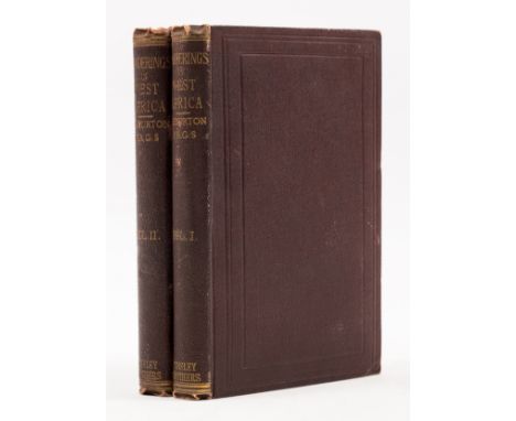
Lot 2
Africa.- Burton (Sir Richard Francis) Wanderings in West Africa from Liverpool to Fernando Po, 2 vol., first edition, half-titles, folding lithographed map, wood-engraved frontispiece in vol.2, occasional light foxing marks, lower hinge cracking to vol.2, original dark purple cloth, [Penzer pp.71-2], a very good copy, 8vo, 1863.⁂ In 1861 Burton took up the post of British consul on the Spanish island of Fernando Po (Bioko, off Cameroon in West Africa). The work includes descriptions of the gold-mining prospects in both Sierra Leone and Nigeria. Burton was in dispute with Speke over the source of the Nile and was infuriated by the Royal Geographical Society for choosing Speke to lead a second expedition to establish his claim, causing him to issue this work anonymously, although his name does appear on the spines.
Lot 21
NO RESERVE Egypt.- Maspero (Gaston) Egyptian Archaeology, one of 50 large paper copies, translated by Amelia B. Edwards, illustrations, original gilt-stamped vellum, soiled, uncut, 1887 § Whymper (Charles) Egyptian Birds, first edition, colour plates, occasional foxing, endpapers browned, original decorative cloth, A. & C. Black, 1909 § White (Arthur Silva) From Sphinx to Oracle, first edition, plates, illustrations, folding map, original pictorial cloth, slightly rubbed and spine a little faded, 1899; and c.130 others on Egypt, v.s. (c.133)

Lot 40
NO RESERVE Scandinavia.- Brooke (Arthur de Capell) Travels through Sweden, Norway, and Finmark, to the North Cape, without half-title, lithographed frontispiece and 20 plates, 2 hand-coloured, 1 lithographed map, illustrations, scattered spotting, ex-library with occasional ink-stamps, abrasion mark to front pastedown where label removed, later half-cloth, label to upper cover, a little rubbed, slight bumping to corners and extremities, [Abbey Travel 248], 4to, 1823.
![NO RESERVE Scandinavia.- [Rothery (Charles William)] "A Yachting Dabbler". Notes on a Yacht Voyage to Hardanger Fjord, tinted](https://cdn.globalauctionplatform.com/2b0e366d-3c7e-4c46-ae34-afa500c1c044/2ef945c2-ea89-4c5d-8837-afa50103ace2/468x382.jpg)
Lot 41
NO RESERVE Scandinavia.- [Rothery (Charles William)] "A Yachting Dabbler". Notes on a Yacht Voyage to Hardanger Fjord, tinted lithograph frontispiece, 25 plates, of which 13 tinted lithographs and 1 double-page, folding colour map, short marginal tear to p.99, original cloth, gilt, a little rubbed, slight bumping to corners and extremities, housed in modern slipcase, [1850] § Ross (W. A.) A Yacht Voyage to Norway, Denmark, and Sweden, 2 vol., first edition, lithographed frontispiece, vol. 2 with half-title, spotting and marginal water-staining to frontispiece, trimmed compliments slip of historian and founder of the National Maritime Museum Sir Geoffrey Callender loosely inserted, original cloth, gilt, bumping to corners and extremities, sunned spine, backstrip beginning to split at joints but holding firm, a little rubbed, 1848; 8vo (3)
Lot 51
World.- Sonnini (C. S.) Travels in Upper and Lower Egypt, engraved portrait frontispiece, 27 engraved plates, linen-backed folding map, occasional damp-staining and off-setting, bookplate, contemporary calf, rebacked, rubbed, bumping to corners, 1800 § Allom (Thomas) Constantinople ... Illustrated, 2 vol., additional engraved titles, 1 engraved map, engraved plates, tissue-guards, occasional spotting and damp-staining, contemporary half-calf, rubbed and worn, bumping to corners, n.d. § Pugin (A.) and C. Heath. Paris and its Environs, 2 vol. bound as 1, additional engraved titles, small loss and staining to bottom edge, engraved plates, scattered spotting and staining, one or two pencil notes, new endpapers, contemporary morocco, rebacked, rubbed and worn, bumping to corners, 1833; previous owner's discreet blind-stamp at end, and others similar, v.s. (32)
Lot 56
Britain.- Wright (Thomas) The History and Topography of the County of Essex, 2 vol., engraved vignette titles, folding map and 100 plates after W.H. Bartlett, contemporary and later ink ownership inscriptions to front free endpaper, some offsetting and light foxing, a few plates with slight damp-stain to fore-edge, g.e., 1831-35 § Our National Cathedrals, 3 vol., vol. 1 with additional title in red and black, colour plates and engraved illustrations, light foxing to endpapers, spines a little sunned, 1887-89, contemporary half morocco, spines gilt, rubbed, 4to (5)

Lot 57
Ireland.- Merry (Tom) Map of Ireland, Geography Bewitched, The false Ireland & the true Erin strangling the hag of Hawarden, political and allegorical caricature map showing the British prime-minister, William Gladstone, being strangled by Erin who sits atop a masked terrorist, lithograph printed in colours, sheet 540 x 365 mm (21 1/4 x 14 1/4 in), central horizontal fold, a few small marginal splits, handling creases, unframed, [circa 1890]; together with Johannes Blaeu's map of part of Norway, 'Episcopatus Stavangriae pars Borealis', unframed, [1665] (2)
Lot 59
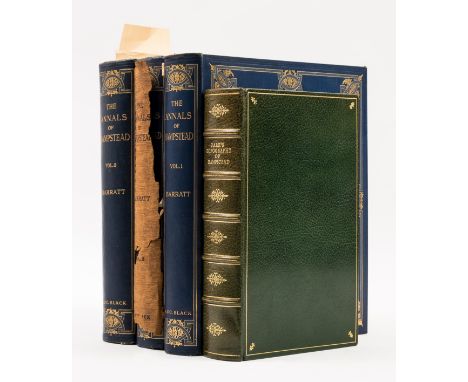
London.- Hampstead.- Barratt (Thomas J.) The Annals of Hampstead, 3 vol., one of 550 copies signed by the author, half-titles, plates, some colour and tipped-in, captioned tissue-guards, illustrations, signed presentation inscription from the author to Arthur E. Fraill "eldest son of my eldest friend...from the age of nine to seventy two" on front free endpaper, dated June 1912, some light foxing, mostly to endpapers, original decorative cloth, gilt, lightly rubbed, vol. 2 with dust-jacket, spine worn with loss and secured with tape, chipped at extremities, g.e., 1912 § Park (John James) The Topography and Natural History of Hampstead, one of 550 facsimile reprints, folding map and tables, crushed emerald morocco by Weatherby Woolnough, gilt, spine slightly sunned, t.e.g., 1982, 8vo & large 4to (4)
Lot 8
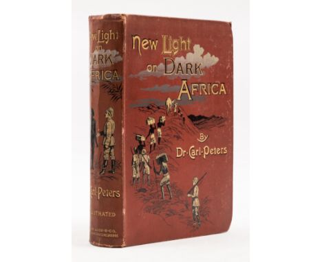
Africa.- Peters (Dr Carl) New Light on Dark Africa, first English edition, portrait frontispiece, title in red and black, plates and illustrations, folding colour map in pocket at end, scattered faint spotting, previous owner's ink signature, bookplate, original pictorial cloth, gilt, slight bumping to corners and spine extremities, a little rubbed, [Czech p.128; Hosken p,157], 8vo, 1891.


![G W BACON: BACON'S NEW CHART OF THE WORLD MERCHATOR'S PROJECTION, Manchester, Royal London Building [1908], large coloured di](https://cdn.globalauctionplatform.com/d0ec2406-3ed7-4541-b523-af8600f80bd6/186808d3-51b0-4184-a901-afad00a92d68/468x382.jpg)


Lot 377
LEWIS MARIANO NESBITT: DESERT AND FOREST THE EXPLORATION OF ABYSSINIAN DANAKIL, London, Jonathan Cape, 1934 first edition, large folding map, original cloth, spine gilt plus RAYMOND LEE DITMARS: THE FOREST OF ADVENTURE, New York, The McMillan Company 1933 first edition, original cloth plus LEONIDAS W RAMSEY: TIME OUT FOR ADVENTURE LETS GO TO MEXICO, New York, Doubleday Doran, 1934 first edition, original cloth gilt, plus EDITH WHARTON: IN MOROCCO, London, McMillan 1920 first edition, original cloth (4)

Lot 393
PETER HENRY EMERSON: 3 Titles: ON ENGLISH LAGOONS BEING AN ACCOUNT OF THE VOYAGE OF TWO AMATEUR WHERRYMAN ON THE NORFOLK AND SUFFOLK RIVERS AND BROADS, London, David Nutt, 1893 first edition, original pictorial cloth d/w (part losses) BIRDS BEASTS AND FISHES OF THE NORFOLK BROADLAND, London, David Nutt, 1895 first edition, first issue, original pictorial cloth worn, spine dulled, MARSH LEAVES FROM THE NORFOLK BROAD-LAND, Stratford, Benjamin Perry, 1898, first edition, folding frontis map, original pictorial cloth gilt worn (3)
![ROBERT MORDEN: LINCOLNSHIRE, engraved part hand coloured map [1695], approx 360 x 410 mm, framed and glazed](https://cdn.globalauctionplatform.com/d0ec2406-3ed7-4541-b523-af8600f80bd6/3e83ddae-d097-4a92-8bac-afad00aa953c/468x382.jpg)

![COSMO MONKHOUSE: NONSENSE RHYMES, ill Gilbert Chesterton, London, R Brimley Johnson [1902], original cloth backed pictorial b](https://cdn.globalauctionplatform.com/d0ec2406-3ed7-4541-b523-af8600f80bd6/be1cc777-a423-459e-8e37-afad00a651df/468x382.jpg)
Lot 67
COSMO MONKHOUSE: NONSENSE RHYMES, ill Gilbert Chesterton, London, R Brimley Johnson [1902], original cloth backed pictorial boards worn, scarce + GILBERT K CHESTERTON: THE NAPOLEON OF NOTTING HILL, ill William Graham Robertson, London and New York, John Lane, 1914, 1st edition, 7 plates, map, as list, original pictorial cloth worn + WILLIAM SOMERSET MAUGHAM: 5 titles: ON A CHINESE SCREEN, London, William Heinemann, 1922, 1st edition, original cloth gilt; THE CASUARINA TREE, London, William Heinemann, 1926, 1st edition, original cloth gilt worn; AH KING, London, William Heinemann, 1933, inscription on ffep, original cloth gilt worn; A WRITERS NOTEBOOK, London, William Heinemann, 1949, 1st edition, inscription on ffep, original cloth; THE COMPLETE SHORT STORIES, London, William Heinemann, 1952 reprint, 3 vols, original cloth, d/ws. slip-case (9)
![THOMAS HARDY: 3 Titles: JUDE THE OBSCURE, London, Osgood Mcilvane, 1896 [1895] first edition, etched frontis and map as calle](https://cdn.globalauctionplatform.com/d0ec2406-3ed7-4541-b523-af8600f80bd6/0cd86be2-a6ce-424a-8e05-afad00a6911f/468x382.jpg)
Lot 92
THOMAS HARDY: 3 Titles: JUDE THE OBSCURE, London, Osgood Mcilvane, 1896 [1895] first edition, etched frontis and map as called for, mixed state, original cloth gilt worn and soiled with part losses of cloth, THE WOODLANDERS, London, McMillan, 1912, frontis double page map, 2pp adverts at end, original cloth worn, WINTER WORDS IN VARIOUS MOODS AND METERS, London, McMillan, 1928, original cloth worn (3)
Lot 100
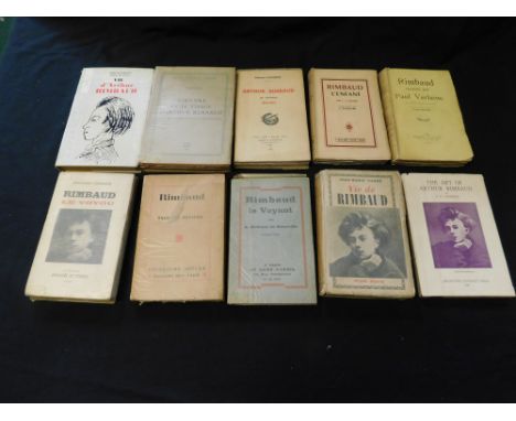
JEAN-MARIE CARRE: LA VIE AVENTURESUSE DE JEAN ARTHUR RIMBAUD, Paris, Librairie Plon, 1926, folding map at end, leaves browned, original pictorial wraps plus ANDRE ROLLAND DE RENEVILLE: RIMBAUD LE VOYANT, Paris, Sans Pariel, 1929 first edition, leaves browned, original wraps, plus ALAN ROLAND CHISHOLM: THE ART OF ARTHUR RIMBAUD, Melbourne University Press, 1930 first edition, original cloth d/w, plus JACQUES RIVIERE: RIMBAUD, Paris, Editions Era, 1930 (1800) numbered (931), original wraps plus BENJAMIN FONDANE: RIMBAUD LE VOYOU, Paris, Denoel Et Steele, 1933 first edition, original pictorial wraps, plus PAUL VERLAINE: RIMBAUD RACONT..., Paris, Mercure, 1934 first edition, leaves browned, original wraps, plus SIMON GODCHOT: ARTHUR RIMBAUD NE VARIETUR 1854-1871, Nice, Chez L'Auteur, 1936 (1000) numbered (857), original wraps plus CECIL ARTHUR HACKETT: RIMBAUD L'ENFANT, Paris, Jose Corti, 1948 first edition, original wraps, plus PIERRE PETITFILS: L'OEUVRE ET LE VISAG D'ARTHUR RIMBAUD, Paris, Nizet, 1949 first edition, leaves browned, original wraps plus HENRI MATARASSO & PIERRE PETITFILS: VIE D'ARTHUR RIMBAUD, preface Jean Cocteau, Paris, Hachette, 1962 first edition, original cloth d/w (10

Lot 186
Staunton (Sir George Leonard) engraved uncoloured map, A Chart of the Islands to the South of the Tchu-San on the Eastern Coast of China, generally laid down from one published by Alexander Dalrymple Esq.with additions and alterations by J. B. Arrow, c.1797, pub. London, W. Bulmer & Co. for G. Nicol, 21¾ x 14in. (55.25 x 35.5cm.); together with Sketch of the Pay-Ho or White River and of the Road from Pekin to Geho, taken 1793, H.W. Parish Royal Artillery, pub. 1796, 18 x 13½in. (45.75 x 34.25cm.), both mounted, unframed. (2)* Condition: - Tchu-San: Occasional spotting. Lower margin has two small tears and other tiny splits - possibly slightly trimmed.- Pay-Ho: Occasional light spotting. Several small handling creases. Otherwise good.


Lot 621
Official GWR and Other Railway Wooden Jigsaws (x7). Comprising:GWR jigsaws (x4) as follows: "Cornwall preparing for a Catch" (unchecked) "Viking Landing at St Ives" ( 3 of 400 pieces missing), "The Cathedral" 150 pieces (complete) with railway map on reverse, "St Julian" 150 pieces (complete)Other: Photochrom: 160 piece "Flying Scotsman" (2 pieces missing, 3 pieces broken) AVN Jones "Six in 1" puzzle of 6x30 pieces (complete but 1 piece broken). Small puzzle 20 piece jigsaw of a blue A4 pacific.(Completeness of jigsaws advised by vendor).

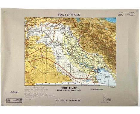
Lot 448
Iraq/Gulf War British Issue Escape Map. A 2002 issue British Escape Map (size 42x30cm) in 1:5,000,000 scale for "UK Defence Purposes Only" printed in simulated micro cloth in full colour. To rear is the legend "I am British, I do not speak your language, I will not harm you" - and also goes on to ask for food and passage and offers a reward for assistance. It is printed in a total of 7 local languages. Unusual item in mint condition in a protective tube.

Lot 690
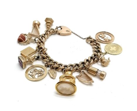
9ct gold charm bracelet (with hand chased decoration to the links) with charms inc 14ct gold map of Switzerland set with a ruby, antique carved amethyst stone set seal fob, antique (touch tests as high carat gold) seal fob, bible, Irish stone set harp etc - total weight 64.2g ~ 1 old repair to a link


Lot 3464
Jurassic Park (1993) - A Framed Prop Display containing a piece of prop Visitors Map from the Film, signed & inscribed by Ariana Richards who played Lex Murphy. 15x12.5x1 inches overall. Provenance: The Prop was originally acquired through Vendors Screenused. The autograph was signed at The London Film & Comic Con on 8th July 2022. With Certificate on reverse.


Lot 286
Maritime interest - 1950s Cunard RMS Queen Elizabeth first class accommodation plan, luncheon and dinner menus, others SS America; Pitt American Football publications program, University of Pittsburgh V University of Oklahoma sept 21st 1957; map; Cunard Chad Valley wooden jig-saw puzzle 2167 Aquitania; wooden sailing boat etc


-
109182 item(s)/page