We found 109198 price guide item(s) matching your search
There are 109198 lots that match your search criteria. Subscribe now to get instant access to the full price guide service.
Click here to subscribe- List
- Grid
-
109198 item(s)/page


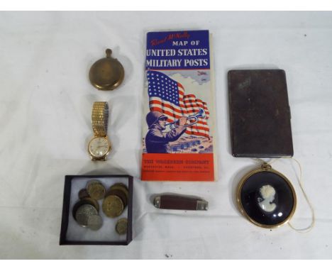
Lot 290
A good mixed lot to include a white metal engine turned cigarette case, a yellow metal pocket watch, Oris wrist watch stamped to the rim with the makers mark, a Cameo, penknife, small quantity of coins and a Rand McNally map of United States military posts This lot MUST be paid for and collected, or delivery arranged, no later than close of business on Tuesday. Please do not bid if you are unable to comply


Lot 1037
Collection of British topographical books, comprising: 'The Beauties of England and Wales', Edward Wedlake Brayley, Vol.X (in five volumes), London: Harris, 1810-1816, numerous engraved plates, modern half-leather bindings; a 19th-century 'Commercial Directory', predominantly for Birmingham/Warwickshire, but including Staffordshire, Shropshire and Worcestershire, including numerous advertisements and several maps; 'Picturesque Views on and near the Eastern Coast of England' (Norfolk interest), James Stark, London: Moon, Boys and Graves, 1834, numerous plates; 'The Picturesque Beauties of Great Britain', Thomas Allen, London: George Virtue, 1833, folding map frontis. and numerous engraved plates; 'Ports and Harbours of Great Britain', William & Edward Finden, London: Charles Tilt, 1838, numerous engraved plates; 'Black's Guide to England and Wales', Edinburgh: Adam & Charles Black, 1870; six catalogues of topography books bound as one volume. Condition varied, not collated, a/f (11)


Lot 1125
Elizabethan Geneva / Breeches Bible. 'The Bible, that is, The holy Scriptures conteined in the Olde and Newe Testament, Translated According to the Ebrew and Greeke, and conferred with the best translations in divers languages', London: Christopher Barker ('Printer to the Queenes most excellent Majestie'), 1599. Woodcut illustration to title page and a few other woodcut vignettes and map within the text. Title page present for 'The Booke of Psalmes' but not to New Testament (though that does close with 'Imprinted at London, Christopher Barker, 1599'). Rebacked with restoration and wear to contents, not collated, book closes at G6 of Book of Psalms.Provenance: Originally from the library of William F. Northend (1887-1968), master printer at Northend's in Sheffield (son of the founder of the firm, J. W. Northend). By descent.


Lot 1160
Blome, Richard (1635-1705). Map of North Wales, c.1673, featuring heraldic shields and decorative cartouche with cherubs. Hand-coloured copper-engraving on laid/chain-lined paper. Unmounted/unframed, 46cm x 35cm. Together with a small 19th-century engraved map showing the 'Mail Road from London to Holyhead'. (2)

Lot 1161
Warwickshire & Worcestershire Interest: Blaeu, Joan (1596-1673). 'Wigorniensis Comitatus et Comitatus Warwicensis nec non Coventrae Libertas'. 17th-century copper-engraving on laid/chain-lined paper, hand-coloured, Latin text to verso, featuring decorative cartouche and heraldic shields. Unframed/unmounted. 59cm x 48cm. Together with a 19th-century engraved map of Birmingham, engraved & published by J. Henshall, published by the Society for the Diffusion of Useful Knowledge, May 15th 1839, mounted but unframed. 41cm x 33cm (mount window). (2)

Lot 1166
Speed, John (1552-1629). 17th-century map of the British Isles, hand-coloured copper engraving on laid/chain-lined paper featuring heraldic shields and vignettes of historical scenes, published by Sudbury and Humble, English text to verso. 'Britain as it was devided in the tyme of the Englishe Saxons'. Framed & glazed to recto and verso. 52cm x 39cm.

Lot 1167
Speed, John (1552-1629). 17th-century map of Lincolnshire, 'The Countie and Citie of Lyncolne', hand-coloured copper engraving on laid/chain-lined paper bearing manufacturer's watermark, featuring ships and sea monsters, heraldic shields, and inset view of Lincoln, Hondius (signed in plate), no publisher specified, English text to verso. Framed & glazed to recto and verso. 51.5cm x 39cm.

Lot 1168
Speed, John (1552-1629). 17th-century map of Lincolnshire, 'The Countie and Citie of Lyncolne', hand-coloured copper engraving on laid/chain-lined paper bearing manufacturer's watermark, featuring ships and sea monsters, heraldic shields, and inset view of Lincoln, Hondius (signed in plate), Bassett & Chiswell, English text to verso. Framed & glazed to recto and verso. 51cm x 39cm.

Lot 1169
Speed, John (1552-1629). 17th-century map of Derbyshire, 'Darbieshire Described', hand-coloured copper engraving on laid/chain-lined paper bearing manufacturer's watermark, featuring heraldic shields and inset views of Derby and Buxton, Bassett & Chiswell, English text to verso. Framed & glazed to recto and verso. 51cm x 39cm.

Lot 1170
Speed, John (1552-1629). 17th-century map of Cheshire, 'The Countye Palatine of Chester with that most ancient citie described', hand-coloured copper engraving on laid/chain-lined paper bearing manufacturer's watermark, featuring ships and sea monsters, heraldic shields and inset view of Chester, Sudbury & Humble, English text to verso. Framed & glazed to recto and verso. 51.5cm x 39cm.

Lot 1171
Speed, John (1552-1629). 17th-century map of Nottinghamshire, 'The Countie of Nottingham described', hand-coloured copper engraving on laid/chain-lined paper bearing manufacturer's watermark, featuring heraldic shields, decorative cartouche with peacocks and inset view of Nottingham, Sudbury & Humble, Hondius signature in plate, English text to verso. Framed & glazed to recto and verso. 51cm x 39cm.

Lot 1172
Speed, John (1552-1629). 17th-century map of The West Riding of Yorkshire, 'with the most famous and fayre citie Yorke described', hand-coloured copper engraving on laid/chain-lined paper bearing manufacturer's watermark, featuring heraldic shields and inset view of York, Sudbury & Humbell, English text to verso. Framed & glazed to recto and verso. 51cm x 39cm.

Lot 1173
Speed, John (1552-1629). 17th-century map of Warwickshire, 'The Counti of Warwick, The Shire Town and Citie of Coventre described', hand-coloured copper engraving on laid/chain-lined paper bearing manufacturer's watermark, featuring heraldic shields, bear & ragged staff, and inset views of Warwick and Coventry. Sudbury & Humble, English text to verso. Framed & glazed to recto and verso. 51.5cm x 39cm.


Lot 1177
Morden, Robert (c.1650-1703). Collection of four antique maps: Leicestershire, Nottinghamshire, Rutland, and Derbyshire. Hand-coloured copper engravings on laid/chain-lined paper; the Leicestershire map bearing manufacturer's watermark of eagle & crown, the Derbyshire map bearing watermark of horse in circle. Unmounted/unframed. (4)

Lot 1178
Morden, Robert (c.1650-1703). Collection of four antique maps: Cornwall, Dorsetshire, Hampshire, and Wiltshire. Hand-coloured copper engravings on laid/chain-lined paper, the Dorsetshire map bearing manufacturer's watermark of eagle & crown, Hampshire and Wiltshire on very fine laid paper, Cornwall mounted in wrappers, the others loose/unmounted. (4)

Lot 1181
Morden, Robert (c.1650-1703). Collection of three antique maps: South Wales, Monmouth, and Herefordshire. Hand-coloured copper engravings on laid/chain-lined paper, the Monmouth map bearing manufacturer's watermark of eagle & crown, the Herefordshire map bearing watermark of horse in circle. (3)

Lot 1184
Speed, John (1552-1629). 17th-century map of Derbyshire, 'Darbieshire Described', hand-coloured copper engraving on laid/chain-lined paper bearing manufacturer's watermark, featuring heraldic shields and inset views of Derby and Buxton, Bassett & Chiswell, English text to verso. Framed & glazed to recto and verso. 52cm x 39.5cm.

Lot 1186
Speed, John (1552-1629). 17th-century map of Somerset, hand-coloured copper engraving on laid/chain-lined paper bearing manufacturer's watermark. Featuring ships at sea, heraldic shields, and inset view of Bath. Sudbury and Humble, English text to verso, framed to recto and verso. 52cm x 39cm. Together with an Ogilby road map, 'London to Barnstaple in Devonshire', framed. (2)

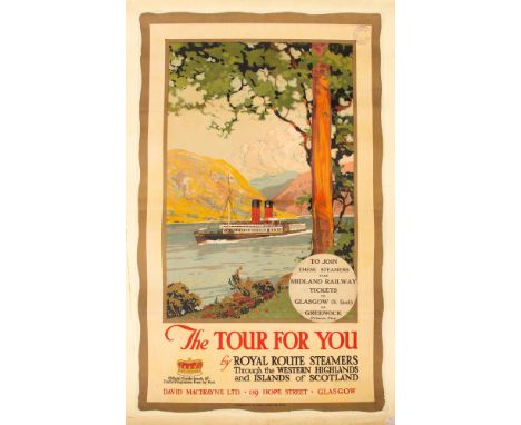
Lot 1221
Original Edwardian Ocean Liner Travel Poster / Advertising / Midland Railway / Scottish Interest: 'The Tour For You by Royal Route Steamers through the Western Highlands and Islands of Scotland', colour lithographic poster, c.1910-1920, bearing original sticker: 'To Join these Steamers take Midland Railway Tickets to Glasgow (St. Enoch) or Greenock (Princes Pier)'. Published by McCorquodale & Co. Limited, Glasgow and London. The poster includes a 'Midland Railway Authorised for Exhibition' stamp at upper-right. 97cm x 59cm. Together with another Edwardian Scottish travel poster, 'To See the Land o' Burns Travel by the Midland & G.&S.W. Railways, the Only Direct Route' (depicting poet Robert Burns standing over a map of Scotland), colour lithograph published by Andrew Reid & Company Ltd, 50 Grey Street, Newcastle-on-Tyne. 98cm x 62cm. Both posters exceptionally vibrant for age, the Burns poster a/f with loss. Each poster has been professionally mounted/backed with linen incorporating archival/conservation materials.
Lot 101
Africa.- Cameron (Verney Lovett) Across Africa, 2 vol., first edition, half-titles, wood-engraved frontispieces, 27 plates, 4 plates of facsimiles (3 folding), folding colour map in pocket at end (slightly browned), wood-engraved illustrations, 8pp. publisher's catalogue at the end of vol. 2, cracked hinges, ink ownership signature to titles, original pictorial cloth, gilt, bumping to corners and spine extremities, [Hosken p.38], 8vo, 1877.

Lot 120
NO RESERVE Saint Helena.- Read (Lieut. R.P.) Geographical Plan of The Island & Forts of Saint Helena, the island orientated with north to the lower left corner, with Napoleon's residence incorrectly identified at Plantation House in the centre of the island, with facsimiles of Napoleon's signatures in the lower right corner, engraved map by Kirkwood, with early hand-colouring, 455 x 600 mm. (17 7/8 x 23 5/8 in), dissected and mounted on linen, with descriptive engraved text verso, folding into contemporary slip-case with title and vignette printed on orange paper, rubbed and worn, 8vo, Burgis & Barefoot and others, October 1815.
Lot 156
Royal Commission on Canals and Waterways. Eight folding maps of canals and waterways, maps comprise 'Map of the Canal Systems and Navigable Rivers of Scotland', 'Map of the Canals and Navigable Rivers of Ireland', 'Map of the Canals & Navigable Rivers in the Catchment Basis of England and Wales', 'Map of the Inland Navigation and Waterways of Belgium', 'General Map of the Navigable Waterways of France', 'Map of the Inland Navigation and Waterways of Germany', 'The Industrial development along the Finow Canal', 'The Industrial Development along the Canalized Main from Frankfurt to Mainz', 8 folding lithographic maps on 8 sheets, approximate dimensions ranging from 450 x 650 mm. to 950 x 600 mm., all dissected onto linen and bound into 5 maroon cloth folders, manuscript paper labels to front boards, worn, [1902-11] (5).⁂ With correspondence from original owner and Photographers Admiralty, dated 1942.
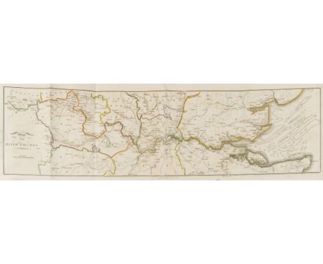
![Agriculture.- [Young (Arthur)] A Six Months Tour through the North of England, containing an Account of the present State of](https://cdn.globalauctionplatform.com/8bfd4c67-462b-4808-a885-a90400f46e61/593a9c27-14b5-4668-ea33-9a227d499aa8/468x382.jpg)
Lot 16
Agriculture.- [Young (Arthur)] A Six Months Tour through the North of England, containing an Account of the present State of Agriculture, Manufactures and Population..., 4 vol., first edition, folding engraved map and 27 plates, 14 folding, 6 folding letterpress tables, 3pp. advertisements at end of vol.1, light offsetting from plates, vol.1 with some ink underlinings and a few pencil annotations, small stain to G6 & 7 of vol.3, later ink inscription on front pastedowns, contemporary speckled calf, rubbed, spine ends a little worn, lacking most labels, upper joint of vol.1 split, 8vo, W.Strahan [&c.], 1770.
Lot 25
London.- Hunter (Rev. Henry) The History of London, and its Environs, in the original 10 parts, first edition, 2 advertisement leaves in part I, list of subscribers in part VIII, 28 engraved plates and plans (one aquatint), 5 folding county maps, folding map of the Thames and large map of environs of London (both hand-coloured in outline, large map loose), lacking Stockdale's large plan of London from part 2, part V with large folding key to panorama but without panorama itself (as issued), part VIII with tipped-in printed labels on pink paper, occasional spotting or soiling but generally clean, one or two plates with light water-staining, mostly marginal, a few marginal tears or defects, original blue wrappers with printed labels on upper wrappers, uncut, rubbed, spines worn and defective, upper wrapper of part I stained, wrapper of part II lacking and part III's defective, some detached, 4to, John Stockdale, 1796-1811.⁂ An Advertisement in part V announces the inclusion of the key plate but offers the large panorama for sale separately "as it has been suggested that the View itself would be a desirable addition to the present work".


Lot 99
Zoology.- Melville (R. V.) & J.D.D. Smith, editors, Official Lists and Indexes of Names and Works in Zoology, ink signature to blank prelim, 8pp. typewritten supplement loosely inserted, original roan, 1987 § Wieland (G. R.) La Flora Liasica de la Mixteca Alta, ex-Cambridge University Botany School with occasional ink stamps, map, plates, original covers bound at end, contemporary cloth, 2 small paper labels to spine, Mexico, 1914 § Audubon (John James) Audubon's Birds of North America, colour frontispiece, illustrations, original cloth, dustjacket, Seacacus, 1990; and 18 others, similar, v.s. (21)


Lot 875A
GREENWOOD & CO; 'Map of The County of Hereford from an Actual Survey made in the year 1831', later coloured, 58 x 70cm, and another of the South-East of England, both framed and glazed (2). CONDITION REPORT: Second map heavily spotted/foxed, fold to centre and wavy. Greenwood map: slightly wavy, some foxing and marks.


-
109198 item(s)/page