We found 109182 price guide item(s) matching your search
There are 109182 lots that match your search criteria. Subscribe now to get instant access to the full price guide service.
Click here to subscribe- List
- Grid
-
109182 item(s)/page
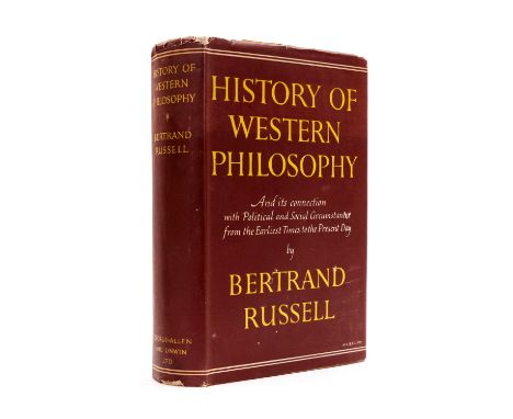


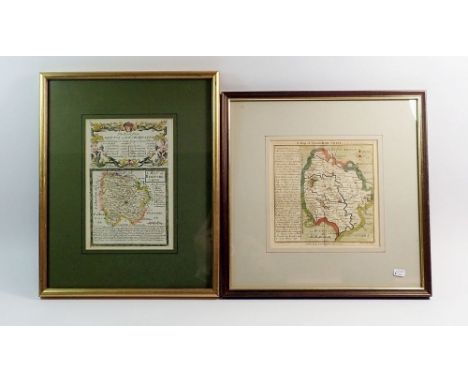
Lot 291
PIM CAPTAIN BEDFORD & SEEMANN BERTHOLD. Dottings on the Roadside in Panama, Nicaragua & Mosquito. Tinted litho frontis & plates. Fldg. map, another map & text vignettes, all as called for. Orig. yellow/orange cloth, fading & mkg. 1869; also Charnay, The Ancient Cities of the New World, fldg. map & many illus., royal 8vo, recased, 1887. (2).


Lot 290
BOYLES MURRAY REV. THOS. Pitcairn, The Island, The People and The Pastor. Eng. frontis & 14 plates & chart, as called for. Orig. green cloth gilt. 1856; also another edition of the same, n.d.; also J. Chalmers & W. Wyatt Gill, Work & Adventure in New Guinea, frontis, plates & fldg. map, attractive orig blue pict. cloth gilt, 1885. (3).


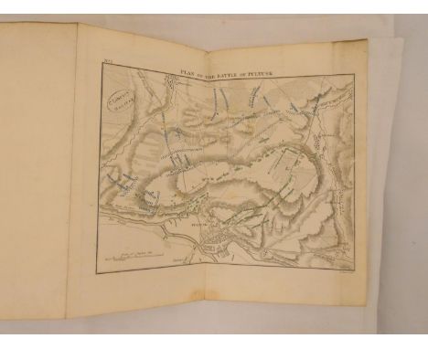
Lot 263
WILSON SIR ROBERT. Brief Remarks on the Character & Composition of the Russian Army & A Sketch of the Campaigns in Poland in the Years 1806 & 1807. Large fldg. eng. map & 7 fldg. & other eng. battle plans, as called for. Quarto. Rebacked qtr. calf, some internal soiling & spotting but a good enough copy. 1810.


Lot 69
MURRAY CHARLES AUGUSTUS. Travels in North America including a Summer Residence with the Pawnee Tribe of Indians ... & a Visit to Cuba & the Azore Islands. 2 vols. in one. Orig. embossed red cloth with gilt figure to back, some wear but a sound copy. 1854; also James Stuart, Three Years in North America, 2 vols., fldg. map, rather crude rebound half calf, Edinburgh, 1833. (3).

Lot 256
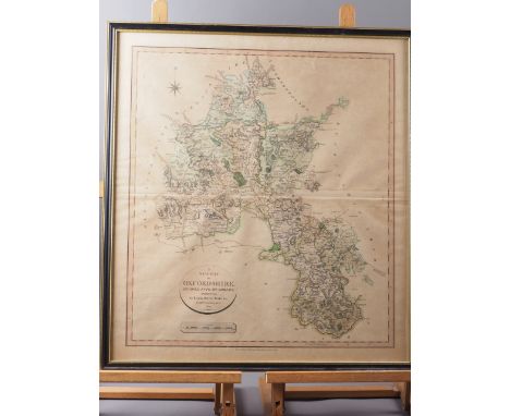
ESHELBY HENRY DOUGLAS. The Genealogy of the Family of De Eskelby or Erelby of the North Riding of the County of York. Ltd. ed. no. 13 of only 40. Double page col. map. Plates & pedigrees. Orig. red cloth, some wear & slight loss to back strip. Pres. copy from the author & Eshelby Family bookplates. Privately Printed, 1891.

Lot 252
FOSTER CHARLES WILMER & GREEN J. J. History of the Wilmer Family. Fldg. map & pedigrees. Quarto. Poor bdgs. Leeds, 1888; also Joseph Foster, Pease of Darlington with Notices of the Families of Robson, Backhouse, Dixon & others, pedigrees & blank interleaves, quarto, stained & mkd. orig. red cloth, Private Circulation, 1891. (2).


Lot 193
PATERSON DANIEL. A New & Accurate Description of All the Direct & Principle Crossroads in England & Wales. Eng. double page map. 9th ed., 1792. Bound in old calf with Daniel Paterson, A Travelling Dictionary or Alphabetical Tables of the Distance of All the Principle Cities, Borough, Market & Sea-Port Towns in Great Britain ... Comprehending Above Fifty Thousand Distances, 6th ed., 1792.


Lot 247
SPEED JOHN. Barkshire Described. Antique hand col. double page eng. map with vignettes & an extensive view of Windsor Castle, English text to reverse "To be sold by Thomas Bassett in Fleet Street & Richard Chiswell in St. Paul's Churchyard". 16" x 20.5". 17th cent. In oak frame, glazed to both sides.
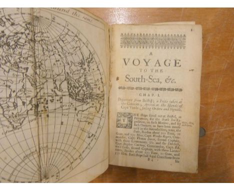
Lot 227
COOKE CAPT. EDWARD. A Voyage to the South Sea and Round the World Perform`d in the Years 1708, 1709. 1710 & 1711. Title relaid. Fldg. dbl. globe eng. map of the world & 8 eng. single page plates (thus 9 plates only of 20 but textually complete). Defective bdgs., lower brd. det. but present, worn cond. & some leaves tending loose. Printed by H.M. for B. Lintot & R. Gosling, 1st. ed., 1712. On this voyage they discovered castaway Alexander Selkirk on Juan Fernandez island: the real-life story that inspired Daniel Defoe to write Robinson Crusoe. The map plate of Juan Fernandez is present (p.99).

Lot 289
ROWLANDS HENRY. Mona Antiqua Restaurata ... on the Antiquities, Natural & Historical of the Isle of Anglesey. 12 eng. plates, as called for. No map. Quarto. Errata & advert leaf. 1766; bound in worn qtr. leather with (John Thomas), A History of the Island of Anglesey ... Serving as a Supplement to Rowlands' Mona Antiqua Restaurata to which are also added Memoirs of Owen Glendowr, half title, title & eng. map, 1775.


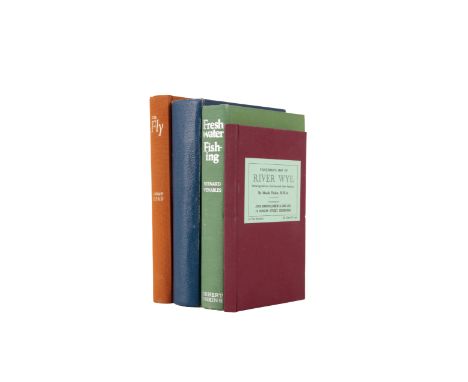
Lot 305
PARKER RWA, MAUDE: "Fisherman's Map of the River Wye Showing Salmon Catches and other features"published by John Bartholomew & Son Ltd, 12 Duncan Street, Edinburgh; Bernard Venables "Freshwater Fishing"; The Journal of the Malayan Angling Association; and Andrew Heard "The Fly" (4)Provenance: From a private Midlands vintage fishing tackle collection.


![British A group of four prints [a] 19th Century, A view outside Bristol, coloured lithograph on paper [b] Sir William Nichols](https://cdn.globalauctionplatform.com/3c99a0a0-f873-4281-9f77-b0ff00bffc58/3cd6e10e-f64f-4b4d-86b8-b100010fb930/468x382.jpg)
Lot 421
British A group of four prints [a] 19th Century, A view outside Bristol, coloured lithograph on paper [b] Sir William Nicholson, An Almanac of Twelve Sports, coloured lithograph on paper [c] Bowen/Owen, Circa 1720, A map of Wiltshire [d] Liam Thompson (b. 1956), Love In A Mist, coloured lithograph [e] 20th Century, A study of geranium sanguineum To be sold without reserve Dimensions: [a] (Paper) 9 in. (H) x 15 in. (W); (Frame) 16 in. (H) x 23 in. (W) [b] (Image) 8 in. (H) x 8.5 in. (W) [c] (Image) 7.5 in. (H) x 4.75 in. (W) [d] (Image) 7.75 in. (H) x 7.75 in. (W) [e] (Paper) 8 in. (H) x 5.5 in. (W); (Frame) 15.25 in. (H) x 12 in. (W)


Lot 219
THE WORLD OF MERCANTORS PROJECTION, 1854. Annotated world map of R W Poore, CPT of the 8th King's Royal Irish Hussars, charting his journey from Queenstown (now Cobh) at 5pm, 8th October 1857 to Bombay 5pm, 17th December 1857. Linen mounted and folded (rip to bottom right corner), size approximately: 81x126cm
Lot 334
After John Ogilby (1600-1676), THE ROAD FROM WELSHPOOL COM MONTGOMERY TO CARNARVON IN NORTH WALES, a strip road map on paper, second edition, later hand coloured, visible plate mark, the plate 34cm x 42.5cm, framed and glazed, text from the first edition applied verso; with an Owen Bowen strip map on laid paper showing roads from Anglesey to North Wales and Chester, 18.5cm x 12cm, in double-sided glazed frame (2)
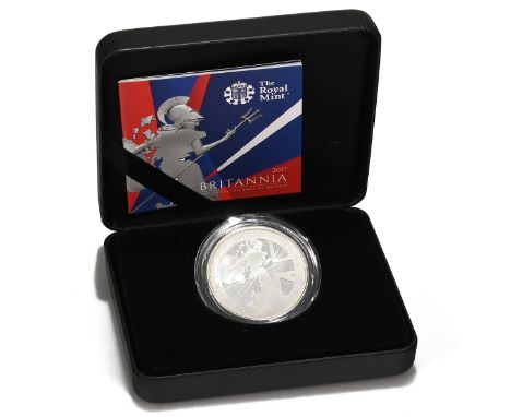
Lot 303
2017 Britannia 1oz silver proof coin in the original Royal Mint presentation packaging with certificate. Obverse: Jody Clark's fifth and final definitive portrait of Queen Elizabeth II, facing right, 'ELIZABETH II · D · G · REG · F · D · 2 POUNDS ·' around. Reverse: map of Great Britain and Northern Ireland overlaid on the figure of Britannia with helmet, shield and trident on Union Jack field with trident mint mark to right. Artist: Louis Tamlyn. Legend: 'BRITANNIA 1OZ FINE SILVER 999' with '2017' to the bottom right. Offered in the original Royal Mint packaging with a numbered certificate of authenticity. Mintage: 7.500. Face value: £2. Finish: proof. Composition: 999 silver. Weight: 31.21g. Diameter: 38.61mm.2017, Queen Elizabeth II. Silver Proof One Ounce Britannia. Royal Mint issue, in full packaging.

Lot 6
TALISKER 10 YEAR OLD MAP LABEL ISLAND SINGLE MALT 45.8% ABV / 70cl Even by today’s standards Talisker distillery is a bit out of the way, nestled on the shore of Loch Harport on the west coast of the isle of Skye. This might explain why, in its early days, the distillery frequently changed hands, with owners struggling to turn a profit. It wasn’t until owner Roderick Kemp oversaw construction of a pier in the late 19th century, allowing much easier access for the boats that transported the casks to the mainland, that the distillery’s fortunes began to improve.Despite a minor stumbling block in 1960 when the distillery burned down and had to be completely rebuilt, it has grown to become one of the most recognisable single malt brands in the world.

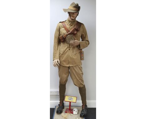
Lot 307
British Boer War Full Uniform, Headdress and Equipment Mannequin of a Private in the 2nd Battalion ‘F’ Company Hampshire Regiment Mounted Infantry, fine khaki four pocket tunic with high collar. Brass post 1902 general service buttons. Brass Hampshire regiment (rose) collar badges and brass HANTS shoulder titles. KD other ranks trousers with khaki putties and black leather boots with stirrups. Complete with a rare early Boer War period enlisted ranks felt slouch hat with cloth pagri and brass 2/MI headdress badge. The set is mounted onto a museum display mannequin with a full set of leather equipment, including cavalry ammunition bandolier, early pattern felt covered water bottle with leather harness and strap, pistol holster with leather cross strap having loops for spare ammunition. Brown leather map / document case with shoulder strap. Enamel drinking cup and heliograph mirror in circular tin. The mannequin is mounted onto a moveable museum display stand. We have not removed any items from this display. We are not able to offer in house post and packing on this lot as it stands, specialist shipping or personal collection recommended. Late Rod Flood collection.

Lot 564
WW2 German 1940 Operation Sea Lion Invasion Maps of Great Britain, interesting grouping housed in the printed card outer cover, consisting of single map of the railway network in the United Kingdom and large reconnaissance book produced on the south coast with printed images and two further smaller reconnaissance books with information produced to be issued for German troops during the aborted German invasion of Great Britain in 1940, code name Operation Sea Lion. All remain in excellent condition.
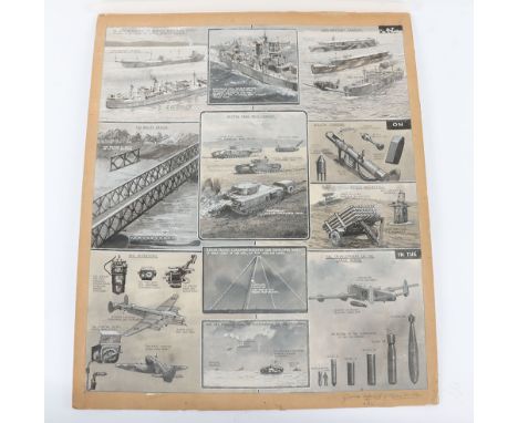
Lot 237
Grouping of Original Artwork by G.H.Davis, the grouping consists of three artists boards, the first being a series of images on one board has as its main theme the Normandy invasion with a drawing of Mulberry Harbour, Pluto (the petrol pipe line) Artificial moonlight etc. Signed by Davis in 1945 and some pencilled notes to margin 11 images in total; second Mix of Images including Magnetic mines and counter measures, use of heavier bombs by the RAF up to 22,000 lbs, Rocket Projectiles, British Tank Development, "Crocodile" Flame Throwing Tank, The Bailey Bridge etc; 3rd board being a map showing Rommel’s defences in North Africa, signed to the bottom corner. G H Davis was a well known artist whose realistic portrayal of aircraft, vehicles, ships, many of them cutaway, made him the Artist of choice for such work during the Second World War. He worked for the Illustrated London News for some forty years and passed away in 1963


Lot 270
George V, Sovereign Mintmark Collection, Perth Mint set comprising 7x George V, sovereigns; 1911 Melbourne Mint, 1912 London Mint, 1913 Sydney Mint, 1918 Bombay Mint, 1919 Ottawa Mint, 1920 Perth Mint and 1927 Pretoria Mint; presented across a map of the world, one time framed but since removed; set no. 236/250; all coins are encapsulated and grading near extremely fine to extremely fine with lustre
-
109182 item(s)/page