We found 108737 price guide item(s) matching your search
There are 108737 lots that match your search criteria. Subscribe now to get instant access to the full price guide service.
Click here to subscribe- List
- Grid
-
108737 item(s)/page


![WITCHCRAFT BOOK,'Salem Witchcraft with An Account of Salem Village' by Charles W Upham. [2 volumes] Boston, Wiggin and Lunt 1](https://cdn.globalauctionplatform.com/3931d079-acf6-41f0-9c01-acef00cb5085/beeae467-1a3b-44a9-9fa2-acef00d53704/468x382.jpg)
Lot 38
WITCHCRAFT BOOK,'Salem Witchcraft with An Account of Salem Village' by Charles W Upham. [2 volumes] Boston, Wiggin and Lunt 1867. Size: 19 x 22cm, hardback, good condition with scuffed covers however the binding of volume 2 is slightly damaged. 469 pages [Vol. 1], 553 pages [Vol. 2]. Both volumes have a frontispiece and volume 1 has a fold-out map and index. Note: This is the First Edition and is No. 67 of a limited edition of only 100 copiesCondition report: Good condition with scuffed covers however the binding of volume 2 is slightly damaged.


Lot 121
A collection of concert, theatre, sports and event tickets; various ages and types, a shoebox full including London's Festival Ballet 1957; Whitney Houston 'The Moment of Truth World Tour' Wembley Arena 14th May 1988 (pair); Dail Mail Ideal Home Exhibition Olympia 1952; (x4) Arsenal v Leicester City Arsenal Stadium Sept 25th; Ice Hockey The Empire Pool, Wembley, 1947; British Games White City Stadium, 1953; Cunard White Star Limited no.4923, 1948; The Everly Brothers, Wembley Arena, 21st Oct 1984; Neil Diamond, Earls Court, 24th June 1984; London Lawn Tennish Championships, Empire Pool, 1957; Olympic Games London 1948 programme and map; and many others.
Lot 122
Collection of ephemera, theatre programmes and sporting brochures; booklets and magazines; including 1947 London underground travel map; Dolphin Holiday Camp booklet, Brixham, Devon; Dunbille's Old Irish Whiskey certificate; Willesden Regatta, Welsh Harp Sailing, 1954, with a badge; London Palladium; Freddy Randall and Eric Silk, Chiswick Empire; and others.


Lot 2822
-- Französische Ausgabe des berühmten Himmelsatlas' Flamsteeds-- Flamsteed, John. Atlas céleste. VIII, 40 S. Mit 30 doppelblattgroßen und in der Platte nummerierten Kupfertafeln. 22 x 15 cm. Halbleder d. Z. (Kapitale mit kleinen Fehlstellen, leicht berieben und bestoßen) mit goldgeprägtem RSchild und RVergoldung. Paris, F. G. Deschamps, 1776.Warner, Sky explored, 84, 1. Shirley C. Flam 1-a Anm. Roller-G. I, 402. Nederl. Scheepvaart Mu. I, 645. Vgl. DSB V, 22f. - Erste Fortin-Ausgabe des berühmten Himmelsatlas. Das englische Original war 1729 erschienen. Die vorliegende Ausgabe wurde um zwei Karten erweitert und im Format verkleinert. "The first 26 [maps] are centered on major constellations visible from Greenwich; the 'extra' map published by Fortin depicts Corvus and the rear half of Hydra, which were omitted from Flamsteed's 'Atlas Coelestis'. For Sharp's northern and southern hemispheres Fortin substitued those of Le Monniert; and he added Lacaille's map of the southern stars and a map for the alignments of the principal northern ones" (Warner). - Stellenweise in der oberen Ecke mit kleinem gebräunten Feuchtigkeitsfleck. Die Tafel 30 im unteren Bug mit längerem Einriss. Gelegentlich mit montierten hs. Zettelchen und selten mit hs. Randanmerkungen. Minimal fleckig.


Lot 730
PRINTS AND ETCHINGS, to include three William Tatton Winter etchings 'Market Square Salisbury', 'Salisbury Cathedral from St Ann's' and 'A Water Mill, Sturry', two Leon Verdier etchings from Rye, hand coloured print of men riding hobby horse bikes 'The Hobby Horse 1819', David Shepherd print signed to the mount of trains, map York to Lancaster from John Ovens Britannia Depicta 1720, various maps of Staffordshire, topographical prints and other assorted prints (box and loose)
Lot 755
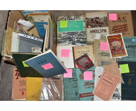
AUTOMOTIVE EPHEMERA, a large collection of books and handbooks, some rare and highly collectable, book titles include Memories of Men & Motor Cars by S.C.H. Davis 1965, Wheel Spin, Competition Motoring from the Driver's Seat by C.A.N. May, This Motoring by Stenson Cooke, published by The A.A. The Motor Manual 33rd Edition 1948, Handbooks, nearly all vintages, include Morris Fourteen-Six Series III, Morris Oxford Series V, Morris Minor 1000 and 1100, The Morris Oxford & Cowley Car Manual 1928 Edition, The Humber Super Snipe Series III, The Hillman Imp 1963, The Sunbeam Rapier Series III, The Riley Elf Mark III, Flying Standard Cars 1936-7, AJS Motorcycle 1946, Raleigh Motorcycles 1931 Models, Royal Enfield 148cc Model X 1933, other publications include The R.A.C. County Road Map and Gazatteer, Gloucestershire, Monmouthshire and Herefordshire 2nd edition plus several other instruction books or manuals

Lot 160
MAVOR, WILLIAM, 'A GENERAL COLLECTION OF VOYAGES AND TRAVELS, FROM THE DISCOVERY OF AMERICA TO THE COMMENCEMENT OF THE 19TH CENTURY, Volume XXIII, printed for Richard Phillips, 1810, with 'A map of Hindoostan including the British Empire in India......', leather binding, front cover detached, foxed and stained
Lot 189
Extensive collection of posters and prints of British History and Paintings, Monthy Python, museum exhibition posters, and educational posters, to include Sir Thomas More and his Descendants, H.M.S. Victory, Florence Nightingale, limited edition historical map of Combs & Battisford, Degas, and others (qty)


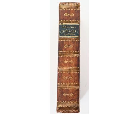
Lot 236a
Amaso Delano, A Narrative of Voyages and Travels in the Northern and Southern Hemispheres, Comprising Three Voyages Round the World, Together with a Voyage of Survey and Discovery, in the Pacific Ocean and Oriental Islands, Second Edition 1818, Printed by E G House for the Author; gilt decorations on the spine and covers, with two engraved portraits and one fold-out map, the first portrait shows Captain Delano, an American sea captain from Duxbury, Massachusetts and author of the book, the second depicts Abba Thulle, King of the Pelew Island, in 1791, with descriptive accounts of some of the voyages Delano’s ship took to various parts of the Pacific, including Hawaii, Palau, the Galapagos Islands, and Australia; his travelogue describes the different cultures he encountered and provides a unique account of the Bounty and Captain Bligh, including an early map of Pitcairn Island, and this may have been the basis for the film “The Mutiny on the Bounty”. A rare book, but a front free endpaper is missing, parts of the map are missing, there is foxing, and the bottom tips have wear. Very desirable. Several modern reprints have been found, but only two original copies on the rare book website we use at the auction house. The book measures 8 3/4 x 5 1/2 in. wide.


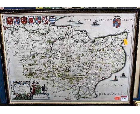
Lot 1047
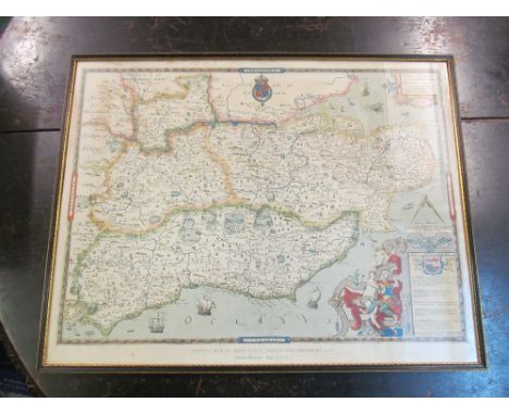
Kent. Blaeu (Johannes) - Cantium Vernacule, Kent, Amsterdam, circa 1645, engraved map with bright contemporary hand colouring, decorative cartouche and mileage scale, Latin text verso, 38 x 53cm, framed and glazedCondition report: Crease to centre.No tears.Very light discolouratino only.Generally very good.


-
108737 item(s)/page