We found 118275 price guide item(s) matching your search
There are 118275 lots that match your search criteria. Subscribe now to get instant access to the full price guide service.
Click here to subscribe- List
- Grid
-
118275 item(s)/page

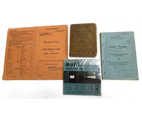
Lot 559
'Signalling: Morse, Semaphore Station Work, Despatch Riding, Telephone Cables, Map Reading' Imperial Army Series, based on training manual- signalling 1915, London, John Murray, Albemarle Street, 1916; together with a Rotor-Tutor 'Morse Indicator' self instructor and practice board; and Royal Air Force 'The Morse Code and How to Learn It' , 1st end. Nov. 1941; Signal Training (All Arms), Pamphlet No.7, Procedure for Radio Telephony, 1952, WO Code No. 8761
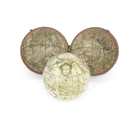
Lot 172
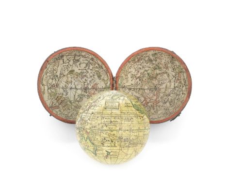
A 2 ¾-INCH TERRESTRIAL POCKET GLOBE AFTER HERMAN MOLL, English, circa 1775,the rectangular cartouche inscribed A Correct Globe With The New Discoveries, Australia and New Zealand are drawn to Cook's discoveries, the fish-skin case lined with celestial paper gores, inscribed Correct Globe with ye New Constelations of Dr Halley & ...' the case with two swivel securing hooks, 3in (7.5cm) diameter Footnotes:Provenance:The Stephen Edell Collection.Herman Moll (fl.1678-d.1732) was a cartographer and map maker of German decent who settled in England in about 1670. A pocket globe by Moll and dated 1719 is in the National Maritime Museum collection Greenwich. It is suggested that the gores were republished in about 1775 with alterations to Australia and New Zealand coastline and showing James Cook's voyage of 1760 and California shown as a peninsular rather than as an island.Literature: For a very similar pocket globe see: Elly Dekker, Globes at Greenwich, London, 1999, p.529.For further information on this lot please visit Bonhams.com
Lot 177
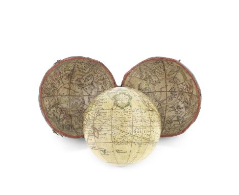
A Nathaniel Hill 2 ¾-inch pocket globe in case, English, circa 1760,the cartouche signed A NEW Terrestrial GLOBE by Nath Hill 1754, twelve hand-coloured engraved gores and two polar calottes, showing New Holland, Dimens Land and New Zealand part-delineated, North-West America labelled Unknown Parts, in original fish-skin case, each interior hemisphere with map of the heavens, 3in (7.5cm) diameter Footnotes:Provenance:The Stephen Edell Collection.Nathaniel Hill (fl.1746-1768) was apprenticed to the globe maker Richard Cushee. In 1751 he became a freeman of the Merchant Taylors' Company and took over the business of John Coggs at the sign of the Globe and Sun in Chancery Lane.For further information on this lot please visit Bonhams.com
Lot 166
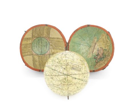
A John and William Cary 2 ¾-inch pocket globe, English, early 19th century,the cartouche printed NEW CELESTIAL GLOBE, printed just outside the cartouche by J & W Cary Strand, with two pivots at the poles, in fish-skin covered case with inner surface applied with coloured map The WORLD as known in Caesar's Time agreeable to D'Auville, the other hemisphere with print A TABLE of Latitudes and Longitudes of Places not given on this GLOBE, 3 1/4in (8.3cm) diameter Footnotes:Provenance:The Stephen Edell Collection.John Cary (1755-1835) founded the family firm, which went on to become one of the most prolific map-makers of the 19th century. John collaborated with his brother William (1758-1798), before his sons entered the firm in the 1820s. After John Cary Jr. died in 1852 the firm's name was updated to 'William Cary'.Literature:Elly Dekker, Globes at Greenwich, London, 1999.For further information on this lot please visit Bonhams.com
Lot 174
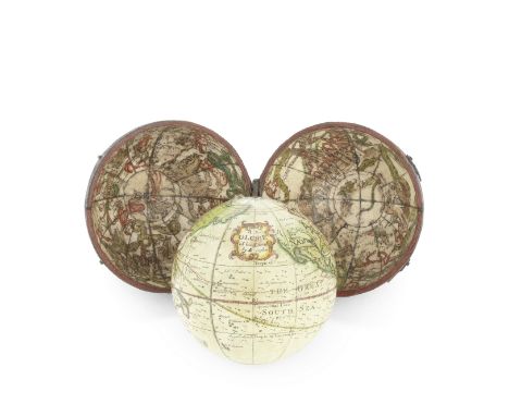
A Richard/Leonard Cushee 2 ¾-inch pocket globe in case, English, circa 1750,signed in a cartouche, A New GLOBE of the Earth by L Cushee (the initial L in manuscript presumably over the printed R), the sphere applied with hand coloured and printed gores, pivot holes at both poles, North America is labelled Unknown Parts and California is shown as a peninsular, the fish-skin case with inner hemispheres applied with hand coloured goes of the celestial sphere, 2 3/4in (7cm) diameter Footnotes:Provenance:The Stephen Edell Collection.Leonard Compere Cushee is recorded at Opposite Temple Gate, Fleet Street, London in 1761 as a map engraver. It is likely that he was the brother or cousin of Richard Cushee (fl. 1730-1750), and his globes were sold from the workshop previously operated by Thomas Wright who collaborated with Richard Cushee on globe and orrery designs. Unusually for pocket globes made in the mid-18th century, the Cushee family used celestial gores which showed the constellations as seen from the Earth rather than from outside.For further information on this lot please visit Bonhams.com
Lot 170
A John Newton 2 ½-inch pocket globe in case, English, circa 1790,the cartouche printed A NEW Terrestrial GLOBE by J Newton 1783, the sphere applied with hand coloured gores showing the trade winds and monsoons indicated by arrows, the Dampier Strait is labelled, Australia and New Zealand are drawn according to Cook's discoveries, and the tracks of Anson's voyage and Cook are shown, in fish-skin covered case with map if the heavens applied to inner two hemispheres, 3in (7.5cm) diameter Footnotes:Provenance:The Stephen Edell Collection.John Newton (1759-1844) founded his family firm in the 1780s, which flourished into the 19th century with support from various family members. The workshop primarily made globes before expanding to include mechanical planetaria. Newton globes were advertised in an unusually broad range of sizes - a total of ten different variations from 1 inch to 25 inches in diameter.For further information on this lot please visit Bonhams.com
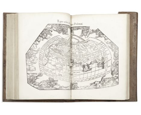
Lot 46
PTOLEMAEUS (CLAUDIUS)Geographicae enarrationis libri octo, woodcut printer's device on title-page, double-column text with woodcut initials, woodcut illustrations (2 full-page, one with image shaved), 50 woodcut maps (49 double-page, mounted on guards), with colophon leaves n4 and [2]h6, text with dampstain in upper margins of first few gatherings and some light browning, occasional light foxing and browning to maps (no. 31 more heavily browned), old inscription and stamp erased from title-page, contemporary wallet-style blindstamped sheep, restored and rebacked preserving original backstrip, metal fasteners with silk ties [cf. Mortimer, Harvard French, 450; Phillips Atlases 366; Sabin 66485], folio (400 x 270mm.), Lyon, Hughes de la Porte [colophons: Vienne, Gaspar Trechsel], 1541Footnotes:The second edition of Ptolemy edited by Servetus, many copies of which are said to have been destroyed on Calvin's orders at the time of the execution of Servetus.The maps are printed from unaltered woodblocks first used in Lorenz Fries's 1522 edition printed by Grüninger (the final map is captioned with this date and Fries's initials), then again in Grüninger's Strasbourg edition of 1525, and in the first Trechsel edition printed at Lyon in 1535. These double-page maps of the ancient and modern comprise: 10 of Europe, 4 of Africa, 12 of Asia, World map, New World, 2 further World maps and 19 others (including Britain and further maps of Africa, Asia and Europe, one with a single-page map on verso). The maps featuring the Americas comprise: Tabula terre nova, number 28, with an account of the voyages and discoveries of Columbus on the verso; Norbegia et Gottia, number 34, showing Greenland as a peninsula of Europe; Tabula nova orbis, number 49, attributed by some to Columbus and known as the 'Admiral's Map', and Tabula totius orbis, number 50, the celebrated new map of the world by Lorenz Fries, the first Ptolomeian map to use the name 'America', on a portion of the South American Continent.This lot is subject to the following lot symbols: •• Zero rated for VAT, no VAT will be added to the Hammer Price or the Buyer's Premium.For further information on this lot please visit Bonhams.com
Lot 82
PLOT (ROBERT)The Natural History of Oxford-Shire, being an Essay towards the Natural History of England, second edition, folding engraved map, 16 engraved plates, contemporary panelled calf, joints cracked, Oxford, Charles Brome, 1705--SKELTON (JOSEPH) Engraved Illustrations of the Principal Antiquities of Oxfordshire, large paper copy, engraved frontispiece (with 'Subscription copy' printed at head), engraved title, county map and 49 plates, all on india paper, engraved illustrations to text, many plates foxed, nineteenth century half morocco, rubbed, 1823; Pietas oxoniensis, or Records of Oxford Founders, engraved frontispiece and 25 plates, all on india paper, light waterstain at head reaching text and images, occasional light foxing, later buckram, 1828, Oxford, J. Skelton, folio (3)Footnotes:Provenance: First work, John Frederick Head, bookplates; Second work, Henry Drummond of Albury Park, bookplate; Third work, Charles Buckeridge, ownership inscription on title.This lot is subject to the following lot symbols: •• Zero rated for VAT, no VAT will be added to the Hammer Price or the Buyer's Premium.For further information on this lot please visit Bonhams.com
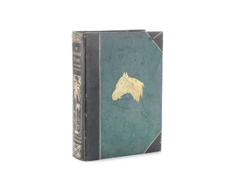
Lot 37
TWEEDIE (WILLIAM)The Arabian Horse. His Country and People with Portraits of Typical or Famous Arabians, FIRST EDITION, NUMBER 26 OF 100 LARGE PAPER COPIES printed on hand-made paper, half-title, 7 chromolithographed plates of horses, 30 other plates and illustrations (mostly on India proof paper), large folding colour-printed map ('country of the Arabian Horse') loose as issued in pocket at end, occasional light spotting, publisher's green half morocco gilt, upper cover gilt-stamped with a picture of an Arab horse, spine with pictorial design of a palm oasis, g.e., some mildew to side-panels, a few scuffmarks [Podeschi 258], folio (345 x 260mm.), Edinburgh, William Blackwood, 1894Footnotes:LARGE PAPER EDITION LIMITED TO 100 COPIES of a classic work devoted to the Arabian horse. Major Tweedie was for many years Consul-General at Baghdad, and Political Resident for the Government of India in Turkish Arabia, but had begun his study of Arab horses whilst serving with the British army in India, where Arab horses were highly prized as gifts amongst the native and colonial rulers.Provenance: C.J. Anstruther, bookplate.This lot is subject to the following lot symbols: •• Zero rated for VAT, no VAT will be added to the Hammer Price or the Buyer's Premium.For further information on this lot please visit Bonhams.com
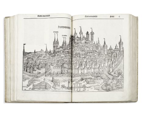
Lot 17
SCHEDEL (HARTMANN)Liber chronicarum, FIRST EDITION, 325 leaves (of 326, without final blank), 65 lines plus headline, gothic letter, woodcut title, approximately 1809 woodcut illustrations printed from 645 blocks by Michael Wolgemut, Wilhelm Pleydenwurff and their workshop, including Albrecht Dürer, comprising 29 double-page town views, 8 full-page woodcuts and double-page maps of the World [Shirley 19] and of Europe by Hieronymus Münzer after Nicolas Khrypffs, washed, title laid down, a handful of stains, a very few leaves shaved touching headline, occasional repaired tears at edges, reaching into text on 6 leaves, fol. 101 repaired at head of gutter with loss to a couple of words and border of illustration, fol. 129-130 mounted on guard, fol. 291 and 296 repaired at blank lower fore-corners, Europe map shaved at fore-edges and with cleanly-repaired tear lower left, sixteenth century blindstamped vellum, rubbed, one corner repaired, new endpapers [ISTC is00307000], folio (410 x 285mm.), Nuremberg, Anton Koberger, 12 July 1493Footnotes:The Nuremberg Chronicle, a pictorial history of the world, is the most lavishly illustrated book of the incunable era. The twenty-nine large double-page city views, many illustrated for the first time, are accurate in depicting particular distinguished features of each city. In addition it includes many details of fifteenth-century daily life: carpenters with their tools, astronomers and their instruments, archers, bridges, derricks, dishes, furniture, windmills, ships, beds, houses, fortifications, weapons, tents, wharves, ferries, books, drawing materials, dogs, horses, and other animals, as well as costumes. Hartmann Schedel's Nuremberg Chronicle epitomizes 'the commercial sophistication, economic power and technical virtuosity that brought the art of print to this extraordinary climax' (Pettegree, The Book in the Renaissance, New Haven, 2011 p.42).Provenance: 'Joannis Baptista Gadii militis', ownership inscription on title.This lot is subject to the following lot symbols: •• Zero rated for VAT, no VAT will be added to the Hammer Price or the Buyer's Premium.For further information on this lot please visit Bonhams.com
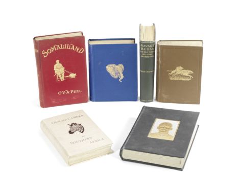
Lot 32
PEEL (CHARLES VICTOR ALEXANDER)Somaliland Being an Account of Two Expeditions into the Far Interior, one corner bumped [Czech p.127], Robinson, 1900--WOLVERTON (LORD) Five Months' Sport in Somali Land, 1894--NEUMANN (ARTHUR H.) Elephant-Hunting in East Equatorial Africa, one colour plate, large folding map in pocket at end, binding stained, 1898--BALDWIN (WILLIAM CHARLES) African Hunting and Adventure from Natal to the Zambezi, third edition, light stains to lower cover, Richard Bentley, 1894--FOA (EDOUARD) After Big Game in Central Africa, first edition in English, light dampstain to half-title, A. & C. Black, 1899--JOHNSTON (HARRY) The Uganda Protectorate, 2 vol., second edition, light stains on one spine, Hutchinson, 1902--CHAPMAN (ABEL) Savage Sudan. Its Wild Tribes, Big-game and Bird-life, light stains to margins of upper cover, Gurney & Jackson, 1921--BRYDEN (H.A.) Kloof and Karroo: Sport, Legend, and Natural History in Cape Colony, binding rubbed, with small loss to blank piece of spine, Longmans, 1889; Gun and Camera in Southern Africa, light bubbling to covers, Edward Stanford, 1893--SWAYNE (H.G.C.) Seventeen Trips Through Somaliland. A Record of Exploration & Big Game Shooting, 1885 to 1893, spine soiled, rubbed, Rowland Ward, 1895--HARRIS (WILLIAM CORNWALLIS) The Wild Sports of Southern Africa, fourth edition, 26 hand-coloured lithographed plates, one folding map, joints split with minor loss, Pelham Richardson, 1844, FIRST EDITIONS unless otherwise stated, publisher's cloth, all but the third and tenth mentioned pictorial gilt, some rubbing, 8vo; and 7 others, big game hunting and exploration in Africa (19)Footnotes:Provenance: C.J. Anstruther, bookplate.This lot is subject to the following lot symbols: •• Zero rated for VAT, no VAT will be added to the Hammer Price or the Buyer's Premium.For further information on this lot please visit Bonhams.com
![HOLINSHED (RAPHAEL)1577. The Firste [-Laste] Volume of the Chronicles of England, Scotland, and Irelande, 2 vol., FIRST EDITI](https://cdn.globalauctionplatform.com/ac67bc36-2f32-4faf-b1ca-ad860115cc32/e2513192-ca2a-4786-a1e6-ad86011f9cd1/468x382.jpg)
Lot 79
HOLINSHED (RAPHAEL)1577. The Firste [-Laste] Volume of the Chronicles of England, Scotland, and Irelande, 2 vol., FIRST EDITION, volume 1 lacking errata leaf r1, volume 2 with title, inserted leaf foliated 1593, map of Edinburgh, and final 4 leaves supplied in facsimile, side-notes and a few catchwords trimmed, nineteenth century diced calf, rebacked, rubbed [ESTC S121346; Pforzheimer 494], folio (275 x 185mm.), Imprinted [by Henry Bynneman] for John Harrison, [1577]Footnotes:Provenance: William, Thomas and Walter Hawes, early ownership inscriptions near end of volume 2; Silvanus Chirm, Kentish Town, stamped ownership mark on flyleaves dated 1785; George Wilbraham (1779-1852), bookplates. Silvanus Chirm was a bookseller who 'made an attempt to replace 'the deceitful Practice of stabbed Bindings' with books sewn on bands' (N. Pickwoad, 'Bookbinding in the eighteenth century,' Cambridge History of the Book in Britain, Volume 5. 1695–1830, p.287).This lot is subject to the following lot symbols: •• Zero rated for VAT, no VAT will be added to the Hammer Price or the Buyer's Premium.For further information on this lot please visit Bonhams.com
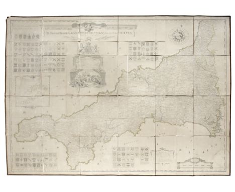
Lot 39
CORNWALLMARTYN (JOHN) A New and Accurate Map of the County of Cornwall, from an actual Survey, FIRST EDITION, very large engraved folding map in 24 sections dissected and mounted on linen, hand-coloured in outline, with pictorial title and dedication cartouche surmounted by Royal arms, inset map of the Isles of Scilly, numerous arms of Cornish families, galleons and historiated compass rose, slightly browned, most central sections and part sections separated but present, some creases and slight chips at section edges, a few small white spots [Rodger 56], overall 1480 x 1860mm., Roberts Sayer, 1748Footnotes:The rare first edition of Thomas Martyn's large scale (one inch to a mile) map of Cornwall, which was normally issued in 9 larger sheets. A financially ambitious undertaking, Martyn's surveying project was underwritten with subscriptions, partly payable in advance and partly on completion. Some 164 subscribers also paid extra to have their coat-of-arms engraved in the border and their county seats named on the map.This lot is subject to the following lot symbols: •• Zero rated for VAT, no VAT will be added to the Hammer Price or the Buyer's Premium.For further information on this lot please visit Bonhams.com
![LONDON - 'WONDERGROUND MAP'[GILL (MACDONALD) The Wonderground Map of London], lithographed pictorial map printed in colours,](https://cdn.globalauctionplatform.com/ac67bc36-2f32-4faf-b1ca-ad860115cc32/c1789637-580a-49c4-b2d5-ad860116a31d/468x382.jpg)
Lot 42
LONDON - 'WONDERGROUND MAP'[GILL (MACDONALD) The Wonderground Map of London], lithographed pictorial map printed in colours, the border with text 'The Field Distemper Fund. If You Want to Save Your Dog from Distemper Send Your Pounds & Your Pence to the Fund' interspaced with a picture of a dog alternating with a dog's gravestone ('Faithful Rover'), with the lion depicted beside the 'on to Wembley' caption, and the cartouche on the righthand side with the address of the Fund ('The Organising Secretary. The Field Distemper Fund, Windsor House, Breams Buildings, London, E.C.4'), a few small tears at folds, 745 x 940mm., Printed by The Westminster Press, Henrietta St., [c.1924]Footnotes:EXTREMELY RARE variant of MacDonald Gill's celebrated 'Wonderground Map of London', issued on behalf of 'The Field Distemper Fund'. The Fund was set up in 1922 'to save the nation's dogs from a deadly disease. Spearheaded by landed patricians associated with the country journal The Field, and funded by dog owners and associations, it relied on collaborations with veterinary professionals, government scientists, [and] the Medical Research Council' ('Saving the Lives of Our Dogs', article by Michael Bresalier and Michael Worboys', British Journal for the History of Science, July 2013). The campaign to raise £25,000, led by Theodore Cook, editor of The Field, was a great success, culminating in the development of a vaccine by 1933. The map, first printed for London Underground in 1914, was amended in 1924 for the British Empire Exhibition with the addition of a lion which is present in this version. The text in the cartouche gives the address of the Fund in place of the original 'Wonderground' title, and has repeated illustrations of a seated dog and a dog's gravestone in the border.This lot is subject to the following lot symbols: •• Zero rated for VAT, no VAT will be added to the Hammer Price or the Buyer's Premium.For further information on this lot please visit Bonhams.com
Lot 100
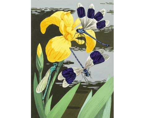
ORIGINAL ARTWORKYUNGE-BATEMAN (JOHN) Three large illustrations of insects (Ruby Tail Wasp; Icheumon wasp; ?purple winged damselflies on a yellow lily), pen, watercolour and gouache on artist's pasteboard, 2 with the artist's name on verso (one with his address of 'The Long House, Angley Park, Cranbrook, Kent'), all with stamp of the 'B.L. Kearley Ltd.' agency, damselfly 390 x 275mm., others 380 x 260mm., undated; [BEES] 'What Insects Do', a complete manuscript maquette of a picture book on bees, attributable to Yunge-Bateman, 46 pages (including pictorial title, double-page map 'Where to look for...[17 types of bees and wasps]', endpapers, etc.), each with illustrations of bees or wasps, 10 in ink with watercolour and gouache, the remainder in pencil, original cloth, 4to (250 x 170mm.), [?1950s/early 60s] (4)Footnotes:Yunge-Bateman (1897-1971) is perhaps best known for the artwork he provided for several Golden Cockerel Press publications (including the Rubaiyat of Omar Khayyam), but from the late 1940s onwards illustrated many children's natural history books, including two devoted to the subject of the bee, as in this mock-up for a book seemingly never to come to press.For further information on this lot please visit Bonhams.com
Lot 34
POTOCKI (JOSEPH)Sport in Somaliland, Being an Account of a Hunting Trip in that Region, NUMBER 186 OF 200 COPIES signed by the publisher, translated from the Polish by Jeremiah Curtin, half-title, chromolithographed frontispiece portrait of the author, 18 photogravure plates (6 double-page), large folding colour-printed map, numerous coloured illustrations in the text, tissue guards, frontispiece loose, one leaf of text (pp.69/70) re-inserted on stub, occasional light spotting, publisher's pictorial white cloth, lettered in gilt, t.e.g., a few small marks but generally clean, folio (390 x 300mm.), Rowland Ward, 1900Footnotes:'One of the rarest of all African big game hunting books' (Czech), recording a hunting trip undertaken by Count Potocki (1862-1922) to the Haud and Ogaden regions of Somaliland in 1895.Provenance: C.J. Anstruther, bookplateThis lot is subject to the following lot symbols: •• Zero rated for VAT, no VAT will be added to the Hammer Price or the Buyer's Premium.For further information on this lot please visit Bonhams.com
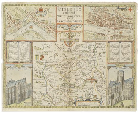
Lot 44
MIDDLESEXSPEED (JOHN) Midle-Sex Described with the Most Famous Cities of London and Westminster, hand-coloured double-page engraved map, inset maps of London and Westminster, and views of St. Paul's and St. Peter's, English text on verso, a few repairs at fold with a few small losses touching letters of title, short tear upper right, 395 x 510mm., Thomas Bassett and Richard Chiswell, [1676, or later]This lot is subject to the following lot symbols: •• Zero rated for VAT, no VAT will be added to the Hammer Price or the Buyer's Premium.For further information on this lot please visit Bonhams.com
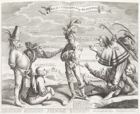
Lot 18
SOUTH SEA BUBBLEHet Groote Tafereel der Dwaasheid, vertoonende de opkomst, voortgang en ondergang der Actie, Bubbel en Windnegotie, FIRST EDITION, title page in red and black (in second state), 76 engraved plates (most folding), printed on various paper stocks, comprising Muller nos. 1-45 (one of the 4 parts of Muller 26 missing and replaced with a non-listed alternative), 47-70, 72-73, plus Muller supplementary numbers 2-4 and 7, with additional state of Muller 65, 8-page manuscript satirical poem in Dutch on rear fly-leaves, text lightly browned, a handful of small wormholes or trails at extremities just touching one letter of one plate, contemporary half vellum, rubbed, inner hinges cracked [Goldsmiths 5879; Kress 3211], folio (385 x 245mm.), [Netherlands], 1720Footnotes:First edition of The Great Mirror of Folly. 'Of the volume's significance in economic literature there can be no doubt.... In neither [England nor France] did there appear such a stout and extravagant piece as this Dutch volume. Constituted of folio size, its bulk is made up largely of satirical plates.... No two specimens, even of approximately the same actual issue date, are exactly the same' (Cole, The Great Mirror of Folly... an Economic-Bibliographical Study, 1949). Prints include portrait of John and Mrs Law, broadsides featuring images and poems, 'Missisippi of 't wydbefaamde Goudland' ('Mississippi, or the world-famous Goldland'), a fanciful map of Louisiana, and 3 sheets of playing cards.This lot is subject to the following lot symbols: •• Zero rated for VAT, no VAT will be added to the Hammer Price or the Buyer's Premium.For further information on this lot please visit Bonhams.com
Lot 36
ROOSEVELT (THEODORE)Hunting Trips of a Ranchman. Sketches of Sport on the Northern Cattle Plains, covers stained (heavier on lower cover), Kegan Paul, 1886; Ranch Life and the Hunting-trail... Illustrated by Frederic Remington, stain to upper cover, 4toT. Fisher Unwin, [c.1888], first English editions--ENGLEHEART (GARDNER N.) Journal of the Progress of H.R.H. The Prince of Wales through British North America, FIRST EDITION, PRESENTATION COPY inscribed 'Forwarded to Colonel Rollo, Military Secretary Canada, by order of H.R.H. The Prince of Wales 26th May 1861' on the half-title, 8 tinted lithographed plates (one double-page), 2 maps (one folding), wood-engraved illustrations in the text, spotting, a few gatherings working loose, light staining to covers, Privately Printed, [1860]--LEFFINGWELL (WILLIAM BRUCE, editor) Shooting on Upland, Marsh, and Stream.... Written by Prominent Sportsmen, Descriptive of Hunting the Upland Birds of America, first English edition, Sampson, Low, 1890--SELOUS (FREDERICK COURTNEY) Sport and Travel East and West, Longmans, 1900--PHILLIPPS-WOLLEY (CLIVE) The Trottings of a Tenderfoot: A Visit to the Colombian Fiords, and Spitzbergen, light staining to covers, lower hinge cracked, 1884; A Sportsman's Eden, 1888, Richard Bentley, FIRST EDITIONS--BUXTON (EDWARD NORTH) Short Stalks: Or Hunting Camps North, South, East and West, 2 vol. [first and second series], second edition of first volume, first edition of second volume, folding map in pocket inside upper cover of second volume, spines soiled, Edward Stanford, 1893-1898, publisher's cloth, most pictorial gilt, rubbing and soiling--MAYER (ALFRED M., editor) Sport with Gun and Rod in American Woods and Waters, 2 vol., title vignettes printed on india-proof paper, publisher's cloth-backed boards, worn, short tears to one spine, t.e.g., Edinburgh, David Douglas, 1884, unless otherwise mentioned 8vo; and 3 others, relating to the Americas (14)Footnotes:Provenance: C.J. Anstruther, bookplate.This lot is subject to the following lot symbols: •• Zero rated for VAT, no VAT will be added to the Hammer Price or the Buyer's Premium.For further information on this lot please visit Bonhams.com
Lot 47
SEUTTER (GEORG MATTHAUS)Atlas novus sive tabulae geographicae totius orbis faciem, partes, imperia, regna et provincias exhibentes..., engraved allegorical title-page by M.G. Grophius after J.C. Weiserman, 50 double-page engraved maps coloured in a contemporary hand, some decorated with allegorical scenes, some general finger-soiling and light staining (mainly towards lower edges/corners, as a result of page-turning, slightly affecting some maps), a few small old paper repairs in margins, contemporary wallet-style limp calf, lettered in blind ('Atlas. Novus. A.L. Mapp.') on upper cover, one leather strap intact, the other loosely inserted, spine and foot of flap restored [Phillips II, 593], folio (550 x 315mm.), Augsburg, Matthaus Seutter, [c.1740]Footnotes:A nice example of Seutter's world atlas in the original wallet-style binding. The maps include the twin-hemisphere World and 'Planispharium coeleste' maps, three of the Americas (including 'Novus orbis sive America meridionalis et septentrionalis'), Asia, and Africa. Seutter was apprenticed to J. B. Homann in 1687 in Nuremberg, then worked as an engraver for the publisher J. Wolff in Augsburg, before setting up his own map and globe business in the same city. Copies of the atlas were issued with very varying numbers of maps.This lot is subject to the following lot symbols: •• Zero rated for VAT, no VAT will be added to the Hammer Price or the Buyer's Premium.For further information on this lot please visit Bonhams.com
Lot 40
DE WIT (FREDERICK)Atlas, engraved title-page depicting Atlas on top of the World and 103 double-page engraved maps COLOURED BY A CONTEMPORARY HAND, most with decorative cartouches, ships and monsters in sea areas, letterpress index on verso of title listing 100 maps, light browning and foxing to some maps, a few old stains and creases, several maps slit at foot of central fold, a few tears and repairs, mostly short and in lower margins, original vellum with blindstamped central globe device surrounded by arabesque tooling, stained and worn at extremities [cf. Koeman Wit 9], folio (540 x 335mm.), Amsterdam, Frederick de Wit, [c.1688]Footnotes:A VERY GOOD COPY OF DE WIT'S ATLAS WITH BRIGHT CONTEMPORARY COLOURING.The fine and attractive double hemisphere world map, Nova orbis tabula, in Lucem edita, was first published in 1670 as a companion to De Wit's maritime map of 1668. Described by Shirley as 'one of the most attractive of its time', the map contains finely engraved and coloured allegorical vignettes depicting the four seasons, the elements and signs of the zodiac. Ours map corresponds to Shirley 451, state 2, with cherubs placed in the cusps and a border added.The map of the Americas, Novissima et accuratissima totius Americae descriptio, dating to around 1675 and replacing De Wit's earlier one of 1660, is notable for its inclusion of the five Great Lakes, which appear for the first time on a Dutch map. Burden has identified 9 states of the map, ours being placed somewhere between the second and fourth, with longitudinal numbers to the 10s, the Canaries re-engraved, no ships, and without the later additions in the Pacific.The number of maps and compilation of the atlas corresponds to Koeman Wit 9, but with the addition of a map of Prussia. In addition to the World map, there are: 4 maps of the Continents, 5 of Asia (2 Middle East and Arabia, Southeast Asia, China, Palestine) and 91 European area maps including Germany (20), Italy (10, Sicily with inset town views), Low Countries (18), Spain/Portugal (7), Greece, the Pelopennese (fine folding map with inset town views), Crete, Malta, Cyprus etc.Provenance: Franz Maximilian Hartmann von Klarstein (1662-1725), ownership inscriptions on front free endpaper and at head of engraved title.This lot is subject to the following lot symbols: •• Zero rated for VAT, no VAT will be added to the Hammer Price or the Buyer's Premium.For further information on this lot please visit Bonhams.com
Lot 29
MARKHAM (FREDERICK)Shooting in the Himalayas. A Journal of Sporting Adventures and Travel in Chinese Tartary, Ladac, Thibet, Cashmere, &c., wood-engraved additional title, 8 tinted lithographed plates (one with short tear), one folding engraved map (short tear), contents shaken, hinges cracked, spine sunned [Abbey Travel 503], Richard Bentley, 1854--DARRAH (HENRY ZOUCH) Sport in the Highlands of Kashmir Being a Narrative of an Eight Month's Trip in Baltistan and Ladak, numerous photographic illustrations, 2 folding maps in pocket at end as issued, spine faded, Rowland Ward, 1898--STONE (S.J.) In and Beyond the Himalayas. A Record of Sport and Travel in the Abode of Snow, 16 plates after Charles Whymper, dampstain to upper fore-edge of frontispiece, a couple of small stains on upper cover, E. Arnold, 1896--MACINTYRE (DONALD) Hindu-Koh: Wanderings and Wild Sport on and Beyond the Himalayas, 8 plates, illustrations in the text, short tear at head of spine, William Blackwood, 1889--KENNION (R.L.) Sport and Life in the Further Himalaya, photographic plates by the author, covers stained, William Blackwood, 1910--TAYLOR (NEVILLE) Ibex Shooting on the Himalayas, 8 plates, abrasions to upper cover, Sampson Low, 1903--[FORSTER (JACK BURTON)] The Sportsman's Vade-mecum for the Himalayas... by K.C.A.J., photographic frontispiece, illustrations, Horace Cox, 1891--KINLOCH (ALEXANDER A.) Large Game Shooting in Thibet, the Himalayas, and Northern India, photographic plates, large folding map (frayed at edges), 4to, Calcutta, Thacker, Spink and Co., 1885, FIRST EDITIONS, publisher's cloth, the first, third to fifth and last mentioned pictorial gilt, some rubbing, all but last mentioned 8vo (8)Footnotes:Provenance: A.J. Anstruther, bookplate.This lot is subject to the following lot symbols: •• Zero rated for VAT, no VAT will be added to the Hammer Price or the Buyer's Premium.For further information on this lot please visit Bonhams.com
Lot 11
MARINONI (GIOVANNI GIACOMO)De astronomica specula domestica et organico apparatu astronomico libri duo, FIRST EDITION, engraved frontispiece by J.J. Sedelmayr after A.D. Bertoli, title printed in red and black with a vignette map of Vienna engraved by J.C. Winkler, 43 engraved folding plates, engraved illustrations (7 full-page), one engraved initial by Winkler, woodcut initials and head-pieces, with final errata and instructions to the binder in Latin and German leaf, some mold stains in blank upper margins, with the first few leaves restored, modern calf preserving some sections of original backstrip, red edges [Kenney, Catalogue of the Rare Astronomical Books in the San Diego State University Library, 115; Poggendorff II, 53; Riccardi II, 119, 'Bellissima ediz.'], Folio (346 x 245mm.), Vienna, Leopoldus Joannes Kaliwoda, 1745Footnotes:First edition of 'one of the most exquisitely illustrated astronomical works ever printed' (Kenney), describing and illustrating the astronomical instruments in the private Viennese observatory of G.J. Marinoni, mathematician and astronomer to the Imperial Court of Austria and geodetic surveyor. The observatory was one of the most beautiful and best equipped in Europe, and the instruments illustrated here include quadrants, telescopes, micrometers, an improved Graham pendulum, and a camera obscura.This copy is complete with the errata/instructions to the binder leaf at the end (Riccardi mistakenly calls for 2 leaves rather than pages, leading to some copies being described as lacking the second errata leaf).This lot is subject to the following lot symbols: •• Zero rated for VAT, no VAT will be added to the Hammer Price or the Buyer's Premium.For further information on this lot please visit Bonhams.com
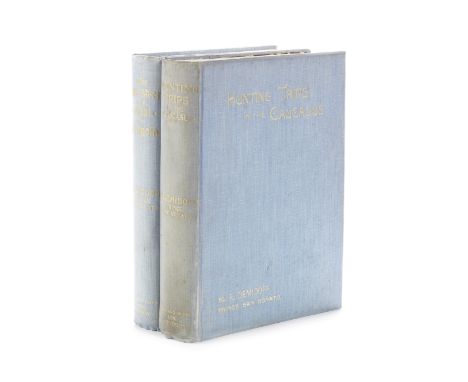
Lot 25
DEMIDOFF (ELIM, PRINCE SAN DONATO)Hunting Trips in the Caucasus, 1898; After Wild Sheep in the Altai and Mongolia, 1900, FIRST EDITIONS, half-titles, frontispieces and illustrations, colour-printed folding map in pocket at end, publisher's light blue cloth, lettered in gilt, zebra-pattern endpapers, spine of first title dulled, some rubbing, large 8vo, Rowland Ward (2)Footnotes:Provenance: C.J. Anstruther, bookplate.This lot is subject to the following lot symbols: •• Zero rated for VAT, no VAT will be added to the Hammer Price or the Buyer's Premium.For further information on this lot please visit Bonhams.com
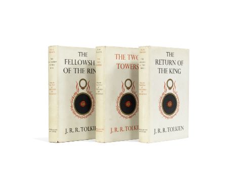
Lot 113
TOLKIEN (J.R.R.)The Lord of the Rings, 3 vol., FIRST EDITION, FIRST IMPRESSIONS, with 'sagging text' on p.49 of 'The Return', each with a folding map printed in red and black, publisher's red cloth, dust-jackets (unclipped, light age soiling to spines, slight wear at spine extremities and corners of folds), 8vo, George Allen and Unwin, 1954-1955This lot is subject to the following lot symbols: •• Zero rated for VAT, no VAT will be added to the Hammer Price or the Buyer's Premium.For further information on this lot please visit Bonhams.com
Lot 33
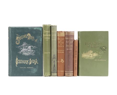
POLLOCK (A.J.O.)Sporting Days in Southern India: Being Reminiscences of Twenty Trips in Pursuit of Big Game, Chiefly in the Madras Presidency, frontispiece and plates after Charles Whymper, errata slip, first tissue guard torn, a few light stains to upper cover, Horace Cox, 1894--HAMILTON (DOUGLAS) Records of Sport in Southern India... edited by his Brother, Edward Hamilton, R.H. Porter, 1892--KIPLING (JOHN LOCKWOOD) Beast and Man in India, illustrations by the author, Munshi Sher Muhammad, Amir Bakhsh and others, a few abrasions to upper cover, Macmillan, 1891--BURTON (E.F.) Reminisicences of Sport in India, 8 plates, rubbed, W.H. Allen, 1885--EDYE (S.J.) Sport in India and Somali Land, with Hints to Young Shikaries, Gale & Polden, [1895]--RICE (WILLIAM) 'Indian Game,' (From Quail to Tiger), 12 tinted lithographed plates, W.H. Allen, 1884--BRADDON (EDWARD) Thirty Years of Shikar, frontispiece, illustrations, one folding map, William Blackwood, 1895--SIMSON (FRANK B.) Letters on Sport in Eastern Bengal, 10 tinted lithographed plates (some loose), binding soiled, R.H. Porter, 1886--JERDON (T.C.) The Game Birds and Wild Fowl of India, some dampstaining, binding dampstained and soiled, Calcutta, for the Author, 1864, FIRST EDITIONS, publisher's cloth, some pictorial, rubbing, 8vo and small 4to; and 12 others, mostly hunting in India (21)This lot is subject to the following lot symbols: •• Zero rated for VAT, no VAT will be added to the Hammer Price or the Buyer's Premium.For further information on this lot please visit Bonhams.com
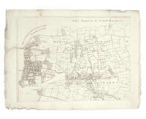
Lot 43
LONDON - EAST END, 1703GASCOYNE (JOEL) An Actuall Survey of the Parish of St Dunstan Stepney, alias Stebunheath, Being One of the Ten Parishes in the County of Middlesex adjacent to the City of London... Taken Anno. Dom. 1703... Engraven by John Harris, large engraved map on 8 irregularly sized sheets, large ornamental title cartouche incorporating an image of St. Dunstan pinching the devil's nose with a pair of Goldsmith's tongs, all sheets with platemarks visible and good borders, 2 sheets with one horizontal tear extending c.140mm. in from the platemark (but no loss), a few edges slightly frayed, largest sheet 510 x 610mm., smallest 106 x 160mm., overall approximately 1110 x 1150mm., Joel Gascoyne, 1703Footnotes:RARE MAP OF THE EAST END OF LONDON, ON 8 SEPARATE SHEETS. Drawn up by the surveyor Joel Gascoyne (1650-705), the map extends from Spitalfields to the River Lea, and Bethnal Green to the Isle of Dogs, encompassing the parishes of Limehouse, Poplar, Mile End Old and New Towns, Ratcliff, Wapping, Spitalfields, Bethnal Green, Bromley and Bow. The irregular size of the sheets, in addition to the East End being at this time an unfashionable working area with much of it yet to be built upon (the Isle of Dogs is all but empty), are perhaps reasons the map is scarce. Each sheet of this set has the platemark and full margins, and appears never to have been stitched or bound.This lot is subject to the following lot symbols: •• Zero rated for VAT, no VAT will be added to the Hammer Price or the Buyer's Premium.For further information on this lot please visit Bonhams.com
Lot 26
DREW (FREDERIC)The Jummoo and Kashmir Territories. A Geographical Account, frontispiece, 4 mounted woodburytype plates of group types, 7 folding colour-printed maps (one in pocket at end as issued), publisher's cloth, soiled, hinges cracked, Edward Stanford, 1875--[ADAIR (FREDERICK E.S.)] Sport in Ladakh. Five Letters from 'The Field', 5 photographic plates, publisher's pictorial cloth gilt, 4to, Horace Cox, 1895--WARD (A.E.) The Sportsman's Guide to Kashmir & Ladak, &c., second and revised edition, 3 folding maps, publisher's limp cloth gilt, soiled, Calcutta, Calcutta Central Press, 1883--BRINKCMAN (ARTHUR) The Rifle in Cashmere: A Narrative of Shooting Expeditions in Ladak, Cashmere, Punjaub, etc., 2 tinted lithographed plates, without tissue guards, later half morocco, rubbed, Smith, Elder, 1862--LISCOMB (HERSCHAU) Astor (Kashmir Territory.). A Journal of Sport and Travel, large folding photozincographed map 'of the District of Astor Kashmir 1888' in pocket at end (early ink annotations including addition of five place names, tear at one fold), later half calf, sides stained, Mussorie, [Privately printed] at the Mafasilite Printing Works, [1888], all but the fourth mentioned FIRST EDITIONS, all but the second mentioned 8vo (5)Footnotes:All relating to Kashmir and Ladakh, including a rare work on hunting in the Astor Territory of Kashmir privately printed at Mussorie, and for which we can find no other copies previously offered at auction.This lot is subject to the following lot symbols: •• Zero rated for VAT, no VAT will be added to the Hammer Price or the Buyer's Premium.For further information on this lot please visit Bonhams.com
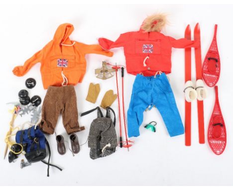
Lot 134
A Quantity of Vintage Original Action Man Uniforms Accessories From 1960’s Artic Explorer, including: Polar Explorer, Anorak, over-trousers, gloves, boots, rucksack, goggles, skis, ski sticks, sextant, snow shoes, helmet, ice axe, goggles, pitons, karabiners, map, radio transmitter, storm lamp lens only, compass, hat, Mountaineer: anorak, knee breaches, boots, rucksack, ice axe, crampons, suckers, Base camp: flag, tent & wire fittings, billycan and wire ladder, all in good to excellent condition. (A.Lot)
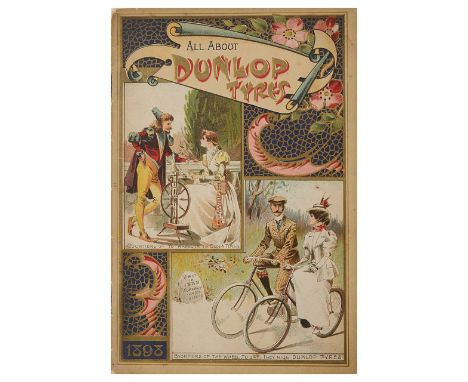
Lot 592
A collection of rare late 19th and early 20th century Continental and British cycling trade catalogues, advertisements, patents, maps and cycle touring guides,to include a c.1896 guide no. 7 in 'The Way About Series of Gazetteer Guides', 'The Way About Hertfordshire', an 1898 booklet for Dunlop Tyres along with a number of 20th century flyers, an 1898 advert for the 'Constra' saddle, an 1899 catalogue for S. de Long & Co., Anvers, the Minerva & Romania bicycles, an 1898 fold-out cycling map of Belgium produced by Touring Club de Belgique, 3rd edition, a late 19th/early 20th century fold-out cyclists map of Bexhill-on-Sea, Eastbourne, Hastings, Rye & District, a 1928 Cyclist's Touring Club Handbook & Guide, a c.1900 Pattisons Whisky Cyclists' Road Map, a 1910 Cycling Pocket Road book, a 1934 John Bull Tourist's Guide in hard cover wallet, a 1901 Chase cycles catalogue, a 1907 Monople Cycles catalogue, trade list and letter, a 1909 catalogue for Cycles ClŽment, Paris, along with another printed flyer, a 1910 catalogue for Nil Supra Cycles, Paris, a scarce c.1912 catalogue for Raleigh Bicycles entitled 'The Book of the Raleigh' with embossed front cover along with other Raleigh related promotional material, a 1917, 1920 and 1938 B.S.A Bicycles catalogue and an early 20th century pamphlet entitled 'A Potted History of the Bicycle', an early 20th century pamphlet 'Cycling Penny Handbooks No. 3: The A.B.C of Cycle Touring' by Reginald Wellbye, a large early 20th century b/w printed image of Paskell's cycling shop, Finsbury, backed with cardboard, a 1988 booklet promoting the history of Reynolds steel tubing, five loose patents from the 1890s relating to bicycle components, (qty)Condition: The collection is in a condition relative to its age, most of the catalogues are held in individual sleeves, some are dog-eared, faded, held together by rusting staples, many have stains and . From the collection of cycling journalist David Taylor (1937-2020).

Lot 23
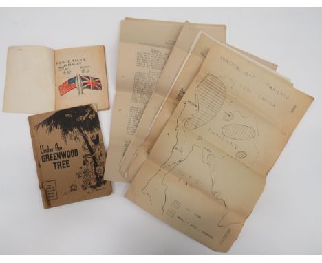
Scarce Far East Escape Packconsisting silk printed, language chart with Union Jack and phrases in various languages including Sumatran, Thai, Burmese and Tamil ... Paper, printed on linen, language chart with central, royal coat of arms and English and Burmese writing ... Double sided, printed silk map 44/C and 44/D .. Heliograph mirror in linen case. All contained in a silver coloured, fabric bag. Belonged to Sergeant J H P Lawrence 62 Sqn.
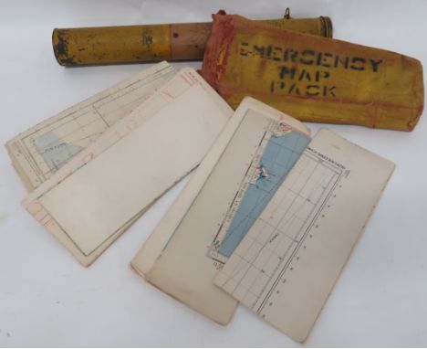
Lot 91
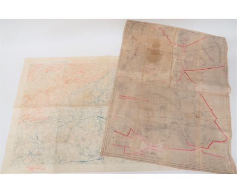
WW2 RAF Emergency Map Pack. .An interesting and unusual example, possibly for Coastal Command aircraft. A yellow painted canvas pack, stencilled “Emergency Map Pack. Containing approximately 20 air maps of the UK and parts of Europe. ... Accompanied by a RAF radio Box Kite. contained in original tin tube. (2 items) . . . .Kite has not been removed from the tin and sold as a historical collectors item as viewed.
Lot 94
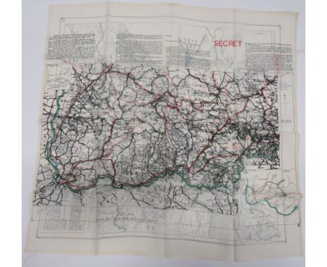
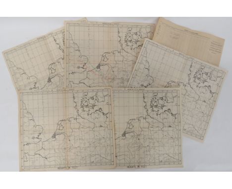
WW2 Bomber Command Operationally Used Captain of Aircraft Maps. .A selection of 5 maps Newcastle to Prague and corrected to 1944. Each map gives details of the route to and from the target with heights and details of the date, target and aircraft code letter. Some with calculations and notes to the reverse. Comprising: 23/12/44 Trier K. ... 28/1/45 Coligne Y. ... 1/2/45 Munchen Gladbach K. ... 14/2/45 Chemnitz K. .... 1/3/45 Kamen K. .... Also a Petrol Log for a Lancaster with some pencil notes. Overall GC used condition (6 items) . . . .Targets and dates are confirmed. The vendor believes the maps relate to 90 Squadron RAF.
Lot 107
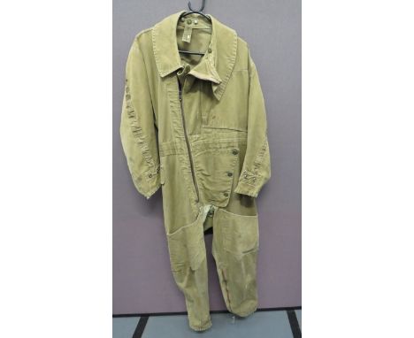
1941 Pattern Electrically Heated Sidcot Suitgreen tan canvas, one piece suit. Offset front, full length body zip. Zips to the ankles and cuffs. Large, open top, leg bag pockets. Left chest angled, open end map pocket. Electrical terminals to the ankles and cuffs. Internal issue label "22C/775" "Size 3". Some service wear and old repairs.
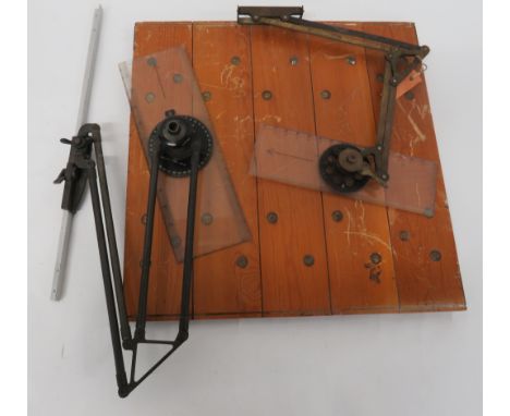
Lot 127
RAF Air Ministry Navigator's Wooden Map Board .A good example with wooden board. The front with hinged perspex cover and adjustable, brass arm with lower directional protractor. Rear of board with AM 1940 stamp, also a canvas pencil holder. .... Together with navigator rule, with brass arm. (2 items) . . . .
Lot 330
Bygone books, etc., an interesting selection to include Warne's Picture Natural History, various other natural history fiction, non fiction, The Electrician's Pocket Book 1949, The Motor Manual Motor, a small quantity of map books, pocket diaries, year books 1913, Great Discoveries, religion, prayer, Biggles and the Black Peril, cookery, Life and Words of Christ, etc., (a quantity).
-
118275 item(s)/page