We found 109182 price guide item(s) matching your search
There are 109182 lots that match your search criteria. Subscribe now to get instant access to the full price guide service.
Click here to subscribe- List
- Grid
-
109182 item(s)/page


Lot 275
John Sturch - A View of the Isle of Wight, 6th edition, published 1796, folding map to front; together with John Albin - Vectiana or a Companion to the Isle of Wight, 6th edition, dated 1808 CONDITION REPORT: John Sturch volume appears complete but uncollated, boards loose; John Albin volume appears complete but uncollated, boards slightly loose


Lot 3367
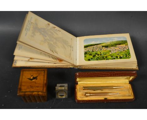
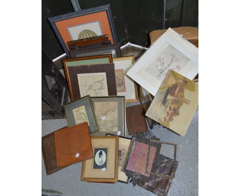
A mid-20th century schoolboy's botany album, collected from a 'Walk from Nottingham Road tram terminus to Coxbench via Breadsall Moor', the album with sixteen pages of botanical specimens preserved beneath tissue paper, including corn poppy, scarlet pimpernel, mallow, hemp kettle and other indigenous plants, the front pastedown with a hand-drawn map of the route in a '[s]cale of three inches to one statue mile', the front cover inscribed 'Form V September 195[?]', the folder 27cm x 38cm overall

Lot 3381
Buffier (Claude), Geografia Universale, Nuova Edizione, Col Trattato della Sfera del medefimo Autore, e Rami nuovi (sic), A Spese di Gregorio, e Michele Stasi Presso Giuseppe di Bisogno, Naples 1771, 442pp + index, various copper plate pull-out maps engraved after Francesco de Grado of Naples, including a hemispherical map of the world, central Europe, eastern Europe, the Balkans, Turkey, Africa, the Americas [with the 'island' of California], 16mo, the leaves measure 15.5cm x 9.3cm, full period vellum

Lot 3390
Glover (Stephen), The History and Gazetteer of the County of Derby: Drawn up from Actual Observation, and from the Best Authorities: Containing the Parochial and Family History, Biography, and Statistical Information, edited by Thomas Noble, Esq., Henry Mozley and Son, Derby 1829-33, volume I and volume II - part II [complete as published], pull-out county map to title page, pull-out pedigrees, original boards, 8vo

Lot 3394
Howitt (William), The Rural Life of England, third edition, Longman, Brown, Green and Longmans, London 1844, small octavo, 615pp + adverts, full gilt tooled red morocco, gilt-edged text block; Dobson (William), A Narrative of the Peninsular Campaign 1807-1814: Its Battles and Sieges, Bickers & Son, London 1897, octavo, 408pp, pull-out three-fold map of Spain and Portugal by W & A.K.Johnston, full red morocco gilt tooled prize binding from the College of Preceptors, presentation plate to front pastedown, gilt-edged text block (2)
Lot 3408
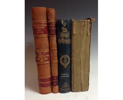
Militaria - Burton (Major R.G.), Wellington's Campaigns in India, printed for Division of the Chief of the Staff, Intelligence Branch: For Official Use only, Superintendent Government Printing, Calcutta 1908; viii + 177pp, map to back sleeve, period half leather, no. 948 in gilt to top corner; Frontier and Overseas Expeditions From India, Compiled in the Intelligence Branch Division of Chief of the Staff Army Head Quarters India, Volume II; North-West Frontier Tribes Between the Kabul and Gumal Rivers, Government Monotype Press, Simla 1908 For Official Use Only., iii + 461pp, map to back sleeve, period half leather, no. 948 in gilt to top corner; Head (The Right Hon. Sir Francis B., Bart.), The Royal Engineer, first edition, John Murray, London 1869, octavo, xii, 391pp + adverts [xx], original cloth boards; Hart (H.G.), The New Army List, And Militia List, for 1857, Woodfall and Kinder, London 1857, octavo, original boards, trade card of H. Kean, 8 Bury Street, St. James, London pasted to title-page (4)

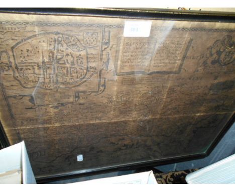
![Joan Blaeu (1596-1673), after, a two-page map, Darbiensis Comitatus, Vernacule Darbie Shire [Derbyshire] (sic), later hand-co](https://cdn.globalauctionplatform.com/5964c851-bc4f-4197-9a6b-a4f801191b59/622c3907-cc9e-45d2-9e52-25ba7d9a9ef8/468x382.jpg)
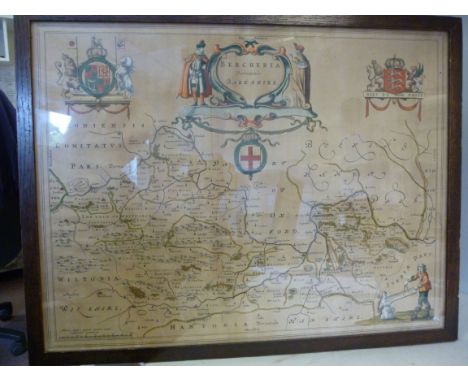
![Johann Christian Harenberg (1696-1774), by, a two-page map, Palestine seu Terra olim Sancta [La Palestine ou La Terre Sainte]](https://cdn.globalauctionplatform.com/5964c851-bc4f-4197-9a6b-a4f801191b59/5a5cdac7-77f6-45ed-b91c-e257034168b7/468x382.jpg)
Lot 3448
Johann Christian Harenberg (1696-1774), by, a two-page map, Palestine seu Terra olim Sancta [La Palestine ou La Terre Sainte], titled in the bottom-right corner within a architectural cartouche, surmounted by a ewer, open writing tablets, books and a crown and other devices emblematic of ancient learning, flanked by a man in stylized traditional dress and a half-prostrate peasant, copperplate engraving and etching, delineations and elevations in land picked out in colour, Nürnberg 1744, 52cm x 62cm

Lot 3449
Johann Christoph Harenberg (1696-1774), a two-page map, Imperii Turcicie Europaei Terra, in primis Graecia, commissioned by Charles Wilhelm Ferdinand of Brunswick-Lüneburg (later known as Charles I, Duke of Brunswick-Wolfenbüttel), Nürnberg 1741, copperplate engraving and etching, delineated in colour, 51cm x 62cm
![Johann Matthias Haas (1684-1742), after, a two-fold map, Carte d' Hongrie [Hungary] (sic), for the Homann Heirs, Nürnberg 174](https://cdn.globalauctionplatform.com/5964c851-bc4f-4197-9a6b-a4f801191b59/f3fb15a2-190f-4479-fdd8-4e63c85bcec1/468x382.jpg)


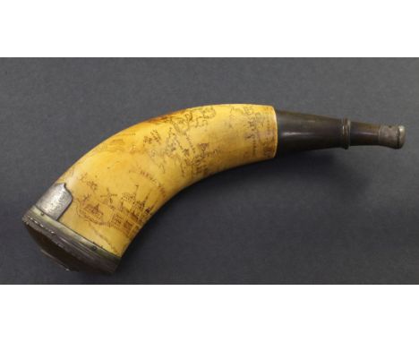
Lot 1
An American Revolution scrimshaw horn powder flask, decorated with a map of towns and forts along the Hudson River including New York, Alverley, Lake Ontario, Fort Edward, Fort Miller, Stillwater etc., also decorated with the British coat of arms, buildings and ships, later converted to a snuff mull with a silver mounted circular horn lid inset with central stone, and a presentation cartouche inscribed and dated 1844, 11in.


Lot 1076
The Championships Wimbledon 1991 Rolled condition 20 x 30 inch colour poster including prices of admission, court details etc. plus three posters in rolled condition 20 x 30 inch from 1996 for The Magic Flute at the Royal Festival Hall, and four posters the same size from 1996 for Summer in the City of London Festival at the Barbican centre x 4, plus a rolled condition poster of the south east view of Mannorbeer Castle, Pembroke and a view of Picton, Pembroke measuring 11 x 17 inch and a smaller map of Wales. A summer Dawna Barton Watercolours rolled poster measuring 20 x 35 inch. Plus three Romeo and Juliet rolled posters from 1996 Battersea Park, Circus theatre and five rolled condition posters for the 6th Barclays new stages festival of Independent theatre from 1996. twenty posters. Excellent condition.

Lot 1109
A collection of New York / American posters including A Metroploitan transportation authority poster for New York Harbour, The Gateway to Manhattan by Richard Bosman (29 x 45 inch) - excellent folded condition. Plus New York V & A Photography poster Park Avenue New York by Garry Winogrand (1959 gelatine silver print 1996 poster) x 2 - excellent folded condition. Plus rolled New York City Charter (30 x 46 inch) road map of the city from 1988 by Patrick Merrell - excellent condition. Plus And I love New York poster 1982 Rolnik publishers (folded, tear, paper snag). Plus an American Express foriegn exchange large poster (excellent condition). A Harlem MTA 29 x 45 inch transit poster,. and 3 x Heathrow Underground terminal posters in excellent folded condition. 10 posters.


-
109182 item(s)/page